Property Information
mobile view
| Serial Number: 03:067:0025 |
Serial Life: 2008... |
|
|
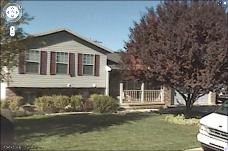 Total Photos: 2
|
| |
|
|
| Property Address: 483 N 100 WEST - PLEASANT GROVE |
|
| Mailing Address: 483 N 100 W PLEASANT GROVE, UT 84062-2110 |
|
| Acreage: 0.222182 |
|
| Last Document:
32248-2014
|
|
| Subdivision Map Filing |
|
| Taxing Description:
(ROTATED TO S BLK LINE PER BLA SURVEY); COM N 88 DEG 55' 13" W 10 FT & N 1 DEG 4' 47" E 245 FT FR SE COR. LOT 1, BLK. 66, PLAT A, PLEASANT GROVE CITY SURVEY; N 88 DEG 55' 13" W 114.96 FT; N 2 DEG 33' 42" E 85.03 FT; S 88 DEG 55' 13" E 112.76 FT; S 1 DEG 4' 47" W 85 FT TO BEG. AREA 0.222 AC.
*Taxing description NOT FOR LEGAL DOCUMENTS
|
|
- Owner Names
- Value History
- Tax History
- Location
- Photos
- Documents
- Aerial Image
| 2020... |
|
JENSEN FAMILY REVOCABLE TRUST 09-14-2018 THE |
|
| 2020... |
|
JENSEN FAMILY REVOCABLE TRUST 09-14-2018 THE |
|
| 2020... |
|
JENSEN, JONI S |
|
| 2020... |
|
JENSEN, JONI S |
|
| 2020... |
|
JENSEN, PERRY DEAN |
|
| 2020... |
|
JENSEN, PERRY DEAN |
|
| 2019 |
|
JENSEN FAMILY REVOCABLE TRUST 09-14-2018 THE |
|
| 2019 |
|
JENSEN, JONI S |
|
| 2019 |
|
JENSEN, JONI S |
|
| 2019 |
|
JENSEN, PERRY DEAN |
|
| 2015-2018 |
|
JENSEN, JONI S |
|
| 2015-2018 |
|
JENSEN, PERRY DEAN |
|
| 2008-2014 |
|
JENSEN, JONI S |
|
| 2008-2014 |
|
JENSEN, PERRY DEAN |
|
| |
----- Real Estate Values ----- |
---Improvements--- |
---Greenbelt--- |
Total |
| Year |
Com |
Res |
Agr |
Tot |
Com |
Res |
Agr |
Tot |
Land |
Homesite |
Tot |
Market Value |
| 2024 |
$0 |
$197,500 |
$0 |
$197,500 |
$0 |
$261,300 |
$0 |
$261,300 |
$0 |
$0 |
$0 |
$458,800 |
| 2023 |
$0 |
$197,400 |
$0 |
$197,400 |
$0 |
$261,300 |
$0 |
$261,300 |
$0 |
$0 |
$0 |
$458,700 |
| 2022 |
$0 |
$208,300 |
$0 |
$208,300 |
$0 |
$289,500 |
$0 |
$289,500 |
$0 |
$0 |
$0 |
$497,800 |
| 2021 |
$0 |
$148,800 |
$0 |
$148,800 |
$0 |
$211,300 |
$0 |
$211,300 |
$0 |
$0 |
$0 |
$360,100 |
| 2020 |
$0 |
$132,900 |
$0 |
$132,900 |
$0 |
$192,100 |
$0 |
$192,100 |
$0 |
$0 |
$0 |
$325,000 |
| 2019 |
$0 |
$122,100 |
$0 |
$122,100 |
$0 |
$168,000 |
$0 |
$168,000 |
$0 |
$0 |
$0 |
$290,100 |
| 2018 |
$0 |
$111,300 |
$0 |
$111,300 |
$0 |
$146,100 |
$0 |
$146,100 |
$0 |
$0 |
$0 |
$257,400 |
| 2017 |
$0 |
$93,400 |
$0 |
$93,400 |
$0 |
$141,300 |
$0 |
$141,300 |
$0 |
$0 |
$0 |
$234,700 |
| 2016 |
$0 |
$79,000 |
$0 |
$79,000 |
$0 |
$145,400 |
$0 |
$145,400 |
$0 |
$0 |
$0 |
$224,400 |
| 2015 |
$0 |
$79,000 |
$0 |
$79,000 |
$0 |
$126,400 |
$0 |
$126,400 |
$0 |
$0 |
$0 |
$205,400 |
| 2014 |
$0 |
$76,900 |
$0 |
$76,900 |
$0 |
$126,400 |
$0 |
$126,400 |
$0 |
$0 |
$0 |
$203,300 |
| 2013 |
$0 |
$50,900 |
$0 |
$50,900 |
$0 |
$126,400 |
$0 |
$126,400 |
$0 |
$0 |
$0 |
$177,300 |
| 2012 |
$0 |
$48,300 |
$0 |
$48,300 |
$0 |
$124,700 |
$0 |
$124,700 |
$0 |
$0 |
$0 |
$173,000 |
| 2011 |
$0 |
$45,000 |
$0 |
$45,000 |
$0 |
$135,100 |
$0 |
$135,100 |
$0 |
$0 |
$0 |
$180,100 |
| 2010 |
$0 |
$50,000 |
$0 |
$50,000 |
$0 |
$145,377 |
$0 |
$145,377 |
$0 |
$0 |
$0 |
$195,377 |
| 2009 |
$0 |
$77,200 |
$0 |
$77,200 |
$0 |
$122,200 |
$0 |
$122,200 |
$0 |
$0 |
$0 |
$199,400 |
| 2008 |
$0 |
$86,700 |
$0 |
$86,700 |
$0 |
$166,400 |
$0 |
$166,400 |
$0 |
$0 |
$0 |
$253,100 |
| Year |
General Taxes |
Adjustments |
Net Taxes |
Fees |
Payments |
Tax Balance* |
Balance Due |
Tax District |
| 2025 |
$0.00 |
$0.00 |
$0.00 |
$0.00 |
|
$0.00
|
$0.00 |
070 - PLEASANT GROVE CITY |
| 2024 |
$2,162.30 |
$0.00 |
$2,162.30 |
$0.00 |
|
$0.00
|
$0.00 |
070 - PLEASANT GROVE CITY |
| 2023 |
$2,064.95 |
($47.93) |
$2,017.02 |
$0.00 |
|
$0.00
|
$0.00 |
070 - PLEASANT GROVE CITY |
| 2022 |
$2,252.20 |
$0.00 |
$2,252.20 |
$0.00 |
|
$0.00
|
$0.00 |
070 - PLEASANT GROVE CITY |
| 2021 |
$1,945.49 |
$0.00 |
$1,945.49 |
$0.00 |
|
$0.00
|
$0.00 |
070 - PLEASANT GROVE CITY |
| 2020 |
$1,791.08 |
$0.00 |
$1,791.08 |
$0.00 |
|
$0.00
|
$0.00 |
070 - PLEASANT GROVE CITY |
| 2019 |
$1,545.93 |
$0.00 |
$1,545.93 |
$0.00 |
|
$0.00
|
$0.00 |
070 - PLEASANT GROVE CITY |
| 2018 |
$1,450.67 |
$0.00 |
$1,450.67 |
$0.00 |
|
$0.00
|
$0.00 |
070 - PLEASANT GROVE CITY |
| 2017 |
$1,366.49 |
$0.00 |
$1,366.49 |
$0.00 |
|
$0.00
|
$0.00 |
070 - PLEASANT GROVE CITY |
| 2016 |
$1,353.30 |
$0.00 |
$1,353.30 |
$0.00 |
|
$0.00
|
$0.00 |
070 - PLEASANT GROVE CITY |
| 2015 |
$1,308.08 |
$0.00 |
$1,308.08 |
$0.00 |
|
$0.00
|
$0.00 |
070 - PLEASANT GROVE CITY |
| 2014 |
$1,307.01 |
$0.00 |
$1,307.01 |
$0.00 |
|
$0.00
|
$0.00 |
070 - PLEASANT GROVE CITY |
| 2013 |
$1,235.42 |
$0.00 |
$1,235.42 |
$0.00 |
|
$0.00
|
$0.00 |
070 - PLEASANT GROVE CITY |
| 2012 |
$1,232.29 |
$0.00 |
$1,232.29 |
$0.00 |
|
$0.00
|
$0.00 |
070 - PLEASANT GROVE CITY |
| 2011 |
$1,275.23 |
$0.00 |
$1,275.23 |
$0.00 |
|
$0.00
|
$0.00 |
070 - PLEASANT GROVE CITY |
| 2010 |
$1,294.43 |
$0.00 |
$1,294.43 |
$0.00 |
|
$0.00
|
$0.00 |
070 - PLEASANT GROVE CITY |
| 2009 |
$1,218.54 |
$0.00 |
$1,218.54 |
$0.00 |
|
$0.00
|
$0.00 |
070 - PLEASANT GROVE CITY |
| 2008 |
$1,430.47 |
$0.00 |
$1,430.47 |
$0.00 |
|
$0.00
|
$0.00 |
070 - PLEASANT GROVE CITY |
* Note: Original tax amount (Does not include applicable interest and/or fees).
| Entry # |
Date |
Recorded |
Type |
Party1 (Grantor) |
Party2 (Grantee) |
| 52894-2019 |
|
06/12/2019 |
T FN ST |
CAPITAL COMMUNITY BANK |
JENSEN, PERRY DEAN & JONI S |
| 38825-2019 |
05/03/2019 |
05/03/2019 |
BLA |
JENSEN, PERRY DEAN & JONI S |
PUSEY, JEFFREY D & JENNY L |
| 38824-2019 |
05/03/2019 |
05/03/2019 |
BLA |
JENSEN, PERRY DEAN & JONI S |
JENSEN, PERRY DEAN & JONI S |
| 23928-2019 |
03/22/2019 |
03/25/2019 |
CSPWD W |
JENSEN, JONI S |
JENSEN, PERRY DEAN & JONI S TEE (ET AL) |
| 92751-2018 |
09/14/2018 |
09/27/2018 |
SP WD |
JENSEN, PERRY DEAN & JONI S |
JENSEN, PERRY DEAN & JONI S TEE (ET AL) |
| 92750-2018 |
09/14/2018 |
09/27/2018 |
SP WD |
JENSEN, PERRY DEAN |
JENSEN, PERRY DEAN & JONI S TEE (ET AL) |
| 228-2017 |
|
01/03/2017 |
FN ST |
JENSEN, PERRY DEAN & JONI (ET AL) |
CAPITAL COMMUNITY BANK |
| 61826-2014 |
08/25/2014 |
08/29/2014 |
REC |
RIVERS, ROD TEE |
JENSEN, PERRY DEAN & JONI S |
| 61825-2014 |
08/21/2014 |
08/29/2014 |
SUB TEE |
MORTGAGE ELECTRONIC REGISTRATION SYSTEMS INC |
RIVERS, ROD SUCTEE |
| 32249-2014 |
05/09/2014 |
05/14/2014 |
D TR |
JENSEN, PERRY DEAN & JONI S |
COLE TAYLOR BANK |
| 32248-2014 |
05/09/2014 |
05/14/2014 |
WD |
JENSEN, PERRY DEAN & JONI S |
JENSEN, PERRY DEAN & JONI S |
| 158420-2007 |
10/30/2007 |
11/07/2007 |
REC |
RICHARDS, BRUCE L TEE |
YOUNG, MIKE J & CANDICE C |
| 26350-2007 |
02/21/2007 |
02/21/2007 |
MOD AGR |
YOUNG, MIKE J & CANDICE C |
WHOM OF INTEREST |
| 17854-2007 |
09/21/2007 |
02/05/2007 |
BLA |
YOUNG, MIKE J & CANDICE C |
JENSEN, PERRY D & PERY DEAN AKA (ET AL) |
Main Menu Comments or Concerns on Value/Appraisal - Assessor's Office
Documents/Owner/Parcel information - Recorder's Office
Address Change for Tax Notice
This page was created on 3/8/2025 8:02:55 AM |
