Property Information
mobile view
| Serial Number: 49:573:0003 |
Serial Life: 2005... |
|
|
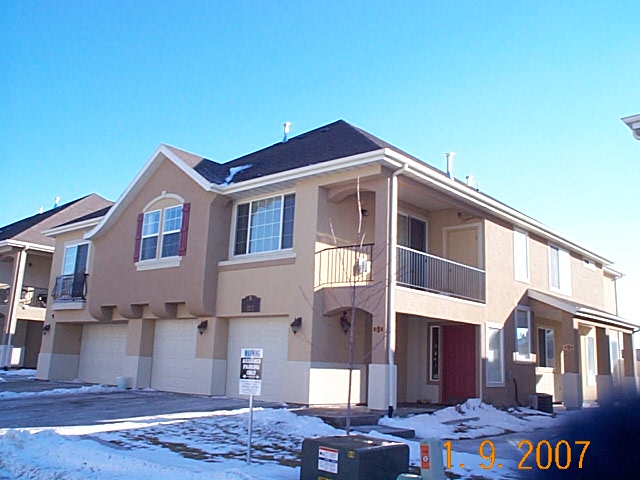 Total Photos: 2
|
| |
|
|
| Property Address: 1671 W 3180 NORTH Unit#3 - LEHI |
|
| Mailing Address: 4176 W SANDALWOOD DR CEDAR HILLS, UT 84062-8514 |
|
| Acreage: 0.029 |
|
| Last Document:
43901-2016
|
|
| Subdivision Map Filing |
|
| Taxing Description:
UNIT 3, BUILDING R, PROVENCE WEST AT PHEASANT POINTE CONDO PHASE 8. AREA 0.029 AC.
*Taxing description NOT FOR LEGAL DOCUMENTS
|
|
- Owner Names
- Value History
- Tax History
- Location
- Photos
- Documents
- Aerial Image
| 2021... |
|
RIVERFRONT PROPERTIES LLC |
|
| 2021NV |
|
LUTJEMEIER, ALISON |
|
| 2020 |
|
RIVERFRONT PROPERTIES LLC |
|
| 2020NV |
|
LUTJEMEIER, ALISON |
|
| 2017-2019 |
|
TRINNAMAN, NICHOLAS L |
|
| 2017-2019 |
|
WILLIAMSON, KATHRYN E |
|
| 2011-2016 |
|
BARRY, STEPHEN JOHN |
|
| 2008-2010 |
|
ENSLOW, MACKENZI |
|
| 2008-2010 |
|
ENSLOW, MARC |
|
| 2007 |
|
CALL, PORTIA |
|
| 2006 |
|
CRM INVESTMENTS 4 LC |
|
| 2006NV |
|
CRM INVESTMENTS 4 LC |
|
| 2005 |
|
CRM INVESTMENTS 4 LC |
|
| 2005 |
|
RICKS, ARTEL |
|
| 2005 |
|
RICKS, FOCHA B |
|
| 2005NV |
|
CRM INVESTMENTS 4 LC |
|
| |
----- Real Estate Values ----- |
---Improvements--- |
---Greenbelt--- |
Total |
| Year |
Com |
Res |
Agr |
Tot |
Com |
Res |
Agr |
Tot |
Land |
Homesite |
Tot |
Market Value |
| 2024 |
$0 |
$36,700 |
$0 |
$36,700 |
$0 |
$293,300 |
$0 |
$293,300 |
$0 |
$0 |
$0 |
$330,000 |
| 2023 |
$0 |
$35,900 |
$0 |
$35,900 |
$0 |
$287,000 |
$0 |
$287,000 |
$0 |
$0 |
$0 |
$322,900 |
| 2022 |
$0 |
$31,000 |
$0 |
$31,000 |
$0 |
$279,000 |
$0 |
$279,000 |
$0 |
$0 |
$0 |
$310,000 |
| 2021 |
$0 |
$28,400 |
$0 |
$28,400 |
$0 |
$208,200 |
$0 |
$208,200 |
$0 |
$0 |
$0 |
$236,600 |
| 2020 |
$0 |
$26,500 |
$0 |
$26,500 |
$0 |
$194,600 |
$0 |
$194,600 |
$0 |
$0 |
$0 |
$221,100 |
| 2019 |
$0 |
$23,600 |
$0 |
$23,600 |
$0 |
$181,200 |
$0 |
$181,200 |
$0 |
$0 |
$0 |
$204,800 |
| 2018 |
$0 |
$21,500 |
$0 |
$21,500 |
$0 |
$157,500 |
$0 |
$157,500 |
$0 |
$0 |
$0 |
$179,000 |
| 2017 |
$0 |
$19,100 |
$0 |
$19,100 |
$0 |
$139,900 |
$0 |
$139,900 |
$0 |
$0 |
$0 |
$159,000 |
| 2016 |
$0 |
$18,000 |
$0 |
$18,000 |
$0 |
$127,000 |
$0 |
$127,000 |
$0 |
$0 |
$0 |
$145,000 |
| 2015 |
$0 |
$18,000 |
$0 |
$18,000 |
$0 |
$127,000 |
$0 |
$127,000 |
$0 |
$0 |
$0 |
$145,000 |
| 2014 |
$0 |
$18,000 |
$0 |
$18,000 |
$0 |
$121,000 |
$0 |
$121,000 |
$0 |
$0 |
$0 |
$139,000 |
| 2013 |
$0 |
$15,200 |
$0 |
$15,200 |
$0 |
$111,600 |
$0 |
$111,600 |
$0 |
$0 |
$0 |
$126,800 |
| 2012 |
$0 |
$15,200 |
$0 |
$15,200 |
$0 |
$111,600 |
$0 |
$111,600 |
$0 |
$0 |
$0 |
$126,800 |
| 2011 |
$0 |
$15,200 |
$0 |
$15,200 |
$0 |
$111,600 |
$0 |
$111,600 |
$0 |
$0 |
$0 |
$126,800 |
| 2010 |
$0 |
$22,000 |
$0 |
$22,000 |
$0 |
$121,400 |
$0 |
$121,400 |
$0 |
$0 |
$0 |
$143,400 |
| 2009 |
$0 |
$22,000 |
$0 |
$22,000 |
$0 |
$124,900 |
$0 |
$124,900 |
$0 |
$0 |
$0 |
$146,900 |
| 2008 |
$0 |
$33,600 |
$0 |
$33,600 |
$0 |
$134,400 |
$0 |
$134,400 |
$0 |
$0 |
$0 |
$168,000 |
| 2007 |
$0 |
$16,000 |
$0 |
$16,000 |
$0 |
$124,000 |
$0 |
$124,000 |
$0 |
$0 |
$0 |
$140,000 |
| 2006 |
$0 |
$16,000 |
$0 |
$16,000 |
$0 |
$96,000 |
$0 |
$96,000 |
$0 |
$0 |
$0 |
$112,000 |
| 2005 |
$0 |
$10,000 |
$0 |
$10,000 |
$0 |
$0 |
$0 |
$0 |
$0 |
$0 |
$0 |
$10,000 |
| Year |
General Taxes |
Adjustments |
Net Taxes |
Fees |
Payments |
Tax Balance* |
Balance Due |
Tax District |
| 2025 |
$0.00 |
$0.00 |
$0.00 |
$0.00 |
|
$0.00
|
$0.00 |
010 - LEHI CITY |
| 2024 |
$1,550.92 |
$0.00 |
$1,550.92 |
$0.00 |
|
$0.00
|
$0.00 |
010 - LEHI CITY |
| 2023 |
$1,397.67 |
$0.00 |
$1,397.67 |
$0.00 |
|
$0.00
|
$0.00 |
010 - LEHI CITY |
| 2022 |
$1,384.12 |
$0.00 |
$1,384.12 |
$0.00 |
|
$0.00
|
$0.00 |
010 - LEHI CITY |
| 2021 |
$1,270.46 |
$0.00 |
$1,270.46 |
$0.00 |
|
$0.00
|
$0.00 |
010 - LEHI CITY |
| 2020 |
$1,201.09 |
$0.00 |
$1,201.09 |
$0.00 |
|
$0.00
|
$0.00 |
010 - LEHI CITY |
| 2019 |
$1,070.19 |
$0.00 |
$1,070.19 |
$0.00 |
|
$0.00
|
$0.00 |
010 - LEHI CITY |
| 2018 |
$989.42 |
$0.00 |
$989.42 |
$0.00 |
|
$0.00
|
$0.00 |
010 - LEHI CITY |
| 2017 |
$909.22 |
$0.00 |
$909.22 |
$0.00 |
|
$0.00
|
$0.00 |
010 - LEHI CITY |
| 2016 |
$893.68 |
$0.00 |
$893.68 |
$0.00 |
|
$0.00
|
$0.00 |
010 - LEHI CITY |
| 2015 |
$941.45 |
($576.35) |
$365.10 |
$0.00 |
|
$0.00
|
$0.00 |
010 - LEHI CITY |
| 2014 |
$907.84 |
($561.13) |
$346.71 |
$0.00 |
|
$0.00
|
$0.00 |
010 - LEHI CITY |
| 2013 |
$897.97 |
($897.97) |
$0.00 |
$0.00 |
|
$0.00
|
$0.00 |
010 - LEHI CITY |
| 2012 |
$922.94 |
($922.94) |
$0.00 |
$0.00 |
|
$0.00
|
$0.00 |
010 - LEHI CITY |
| 2011 |
$917.08 |
($917.08) |
$0.00 |
$0.00 |
|
$0.00
|
$0.00 |
010 - LEHI CITY |
| 2010 |
$973.49 |
$0.00 |
$973.49 |
$0.00 |
|
$0.00
|
$0.00 |
010 - LEHI CITY |
| 2009 |
$886.00 |
$0.00 |
$886.00 |
$0.00 |
|
$0.00
|
$0.00 |
010 - LEHI CITY |
| 2008 |
$959.02 |
$0.00 |
$959.02 |
$0.00 |
|
$0.00
|
$0.00 |
010 - LEHI CITY |
| 2007 |
$777.93 |
$0.00 |
$777.93 |
$0.00 |
|
$0.00
|
$0.00 |
010 - LEHI CITY |
| 2006 |
$686.53 |
$0.00 |
$686.53 |
$0.00 |
|
$0.00
|
$0.00 |
010 - LEHI CITY |
| 2005 |
$125.80 |
$0.00 |
$125.80 |
$0.00 |
|
$0.00
|
$0.00 |
010 - LEHI CITY |
* Note: Original tax amount (Does not include applicable interest and/or fees).
| Entry # |
Date |
Recorded |
Type |
Party1 (Grantor) |
Party2 (Grantee) |
| 19061-2021 |
01/21/2021 |
02/01/2021 |
RSUBTEE |
MORTGAGE ELECTRONIC REGISTRATION SYSTEMS INC (ET AL) |
LUTJEMEIER, ALISON |
| 198378-2020 |
12/11/2020 |
12/14/2020 |
WD |
LUTJEMEIER, ALISON |
RIVERFRONT PROPERTIES LLC |
| 198377-2020 |
12/11/2020 |
12/14/2020 |
D TR |
JEMEIER, ALISON LUT |
SECURITY HOME MORTGAGE LLC |
| 193975-2020 |
11/04/2020 |
12/07/2020 |
WD |
RIVERFRONT PROPERTIES LLC |
LUTJEMEIER, ALISON |
| 66510-2019 |
07/12/2019 |
07/18/2019 |
REC |
MORAN, KEVIN P SUBTEE |
WILLIAMSON, KATHRYN E (ET AL) |
| 66509-2019 |
07/04/2019 |
07/18/2019 |
SUB TEE |
MORTGAGE ELECTRONIC REGISTRATION SYSTEMS INC |
MORAN, KEVIN P SUBTEE |
| 60716-2019 |
06/28/2019 |
07/01/2019 |
WD |
LUTJEMEIER, ALISON |
RIVERFRONT PROPERTIES LLC |
| 60715-2019 |
06/28/2019 |
07/01/2019 |
D TR |
LUTJEMEIER, ALISON |
SECURITY HOME MORTGAGE LLC |
| 60691-2019 |
06/28/2019 |
07/01/2019 |
WD |
WILLIAMSON, KATHRYN E (ET AL) |
LUTJEMEIER, ALISON |
| 43902-2016 |
05/17/2016 |
05/18/2016 |
D TR |
WILLIAMSON, KATHRYN E (ET AL) |
MOUNTAIN AMERICA FEDERAL CREDIT UNION |
| 43901-2016 |
05/17/2016 |
05/18/2016 |
WD |
BARRY, STEPHEN JOHN |
WILLIAMSON, KATHRYN E (ET AL) |
| 76871-2010 |
09/13/2010 |
09/13/2010 |
RSUBTEE |
MORTGAGE ELECTRONIC REGISTRATION SYSTEMS INC (ET AL) |
ENSLOW, MARC & MACKENZI |
| 69927-2010 |
08/18/2010 |
08/19/2010 |
CAN ND |
HALLIDAY, PAUL M JR SUCTEE |
ENSLOW, MACKENZI & MARC |
| 67804-2010 |
08/12/2010 |
08/12/2010 |
WD |
ENSLOW, MARC & MACKENZI |
BARRY, STEPHEN JOHN |
| 44359-2010 |
05/28/2010 |
05/28/2010 |
N |
PROVENCE AT PHEASANT POINTE HOMEOWNERS ASSOCIATION INC |
WHOM OF INTEREST |
| 10161-2010 |
01/28/2010 |
02/04/2010 |
AS |
MORTGAGE ELECTRONIC REGISTRATION SYSTEMS INC |
NATIONSTAR MORTGAGE LLC |
| 3708-2010 |
01/14/2010 |
01/14/2010 |
ND |
HALLIDAY, PAUL M JR SUCTEE |
ENSLOW, MACKENZI & MARC |
| 3707-2010 |
01/14/2010 |
01/14/2010 |
SUB TEE |
NATIONSTAR MORTGAGE LLC |
HALLIDAY, PAUL M JR SUCTEE |
| 114949-2008 |
10/20/2008 |
10/22/2008 |
CT |
STATE OF UTAH |
WHOM OF INTEREST |
| 107508-2008 |
09/30/2008 |
09/30/2008 |
RESOL |
BOARD OF COUNTY COMMISSIONERS UTAH COUNTY |
WHOM OF INTEREST |
| 125099-2007 |
08/17/2007 |
08/24/2007 |
REC |
MORAN, KEVIN P TEE |
CALL, PORTIA |
| 125098-2007 |
08/17/2007 |
08/24/2007 |
SUB TEE |
MORTGAGE ELECTRONIC REGISTRATION SYSTEMS INC |
MORAN, KEVIN P SUCTEE |
| 112186-2007 |
07/31/2007 |
08/02/2007 |
D TR |
ENSLOW, MARC & MACKENZI |
BONAVISTA MORTGAGE LLC |
| 112171-2007 |
07/26/2007 |
08/02/2007 |
WD |
CALL, PORTIA |
ENSLOW, MARC & MACKENZI |
| 141552-2006 |
10/13/2006 |
10/24/2006 |
REC |
US BANK NATIONAL ASSOCIATION TEE |
C R M INVESTMENTS 4 LC (ET AL) |
| 56227-2006 |
05/01/2006 |
05/08/2006 |
ADECCON |
PHEASANT POINTE DEVELOPMENT LC |
WHOM OF INTEREST |
| 14616-2006 |
02/03/2006 |
02/06/2006 |
D TR |
CALL, PORTIA |
AMERICAN HERITAGE MORTGAGE LLC |
| 14615-2006 |
02/03/2006 |
02/06/2006 |
WD |
CRM INVESTMENTS 4 LC |
CALL, PORTIA |
| 111621-2005 |
09/30/2005 |
10/03/2005 |
A AGR |
STATE OF UTAH DEPARTMENT OF ENVIRONMENTAL QUALITY (ET AL) |
WHOM OF INTEREST |
| 11198-2005 |
09/08/2004 |
02/02/2005 |
DECLSUP |
PROVENCE DEVELOPMENT LC |
WHOM OF INTEREST |
| 2582-2005 |
01/05/2005 |
01/07/2005 |
WD |
RICKS, ARTEL & FOCHA B TEE (ET AL) |
CRM INVESTMENTS 4 LC |
| 2581-2005 |
01/05/2005 |
01/07/2005 |
R OPT |
TROPHY HOMES LC |
WHOM OF INTEREST |
| 118996-2004 |
10/18/2004 |
10/19/2004 |
CONSENT |
CRM INVESTMENTS 4 |
WHOM OF INTEREST |
| 117103-2004 |
|
10/14/2004 |
AGR |
PROVENCE DEVELOPMENT LC |
LEHI CITY |
| 115234-2004 |
08/10/2004 |
10/08/2004 |
C PLAT |
PHEASANT POINTE DEVELOPMENT LC (ET AL) |
PROVENCE WEST AT PHEASANT POINTE CONDOMINIUMS PH 8 |
Main Menu Comments or Concerns on Value/Appraisal - Assessor's Office
Documents/Owner/Parcel information - Recorder's Office
Address Change for Tax Notice
This page was created on 2/27/2025 6:18:37 PM |
