Property Information
mobile view
| Serial Number: 11:037:0184 |
Serial Life: 1994... |
|
|
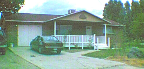
 Total Photos: 2
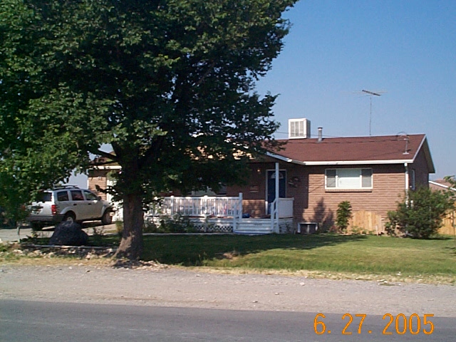
|
| |
|
|
| Property Address: 10545 N 6000 WEST - HIGHLAND |
|
| Mailing Address: 6090 W 10400 N HIGHLAND, UT 84003-9279 |
|
| Acreage: 0.499802 |
|
| Last Document:
32494-2011
|
|
| Subdivision Map Filing |
|
| Taxing Description:
COM N 861.87 FT FR S 1/4 COR. SEC. 35, T4S, R1E, SLB&M.; N 99.97 FT; W 217.99 FT; S 100 FT; N 89 DEG 56' 0" E 217.99 FT TO BEG (DEFECTIVE DESCRIPTION). AREA 0.500 AC.
*Taxing description NOT FOR LEGAL DOCUMENTS
|
|
- Owner Names
- Value History
- Tax History
- Location
- Photos
- Documents
- Aerial Image
| 2019... |
|
10545 N 6000 W PROPERTY LLC |
|
| 2018 |
|
GARRETT, BRIAN |
|
| 2018 |
|
GARRETT, LISA |
|
| 2014-2017 |
|
BRUNSON, BRIAN D |
|
| 2014-2017 |
|
BRUNSON, TRINA D |
|
| 2014NV |
|
BRUNSON, BRIAN D |
|
| 2014NV |
|
BRUNSON, TRINA D |
|
| 2012-2013 |
|
BRUNSON, BRIAN D |
|
| 2012-2013 |
|
BRUNSON, TRINA D |
|
| 2008-2011 |
|
BRUNSON, BRIAN D |
|
| 2008-2011 |
|
BRUNSON, TRINA D |
|
| 2001-2007 |
|
BISHOP, LLOYD K |
|
| 2001-2007 |
|
BISHOP, ROSE |
|
| 1999-2000 |
|
COOK, JACQUETTA RAMONA |
|
| 1999-2000 |
|
COOK, JOHN C |
|
| 1999NV |
|
BROOKS, MARIE C |
|
| 1999NV |
|
BROOKS, NOLAN T |
|
| 1994-1998 |
|
BROOKS, MARIE C |
|
| 1994-1998 |
|
BROOKS, NOLAN T |
|
| |
----- Real Estate Values ----- |
---Improvements--- |
---Greenbelt--- |
Total |
| Year |
Com |
Res |
Agr |
Tot |
Com |
Res |
Agr |
Tot |
Land |
Homesite |
Tot |
Market Value |
| 2024 |
$0 |
$321,500 |
$0 |
$321,500 |
$0 |
$211,800 |
$0 |
$211,800 |
$0 |
$0 |
$0 |
$533,300 |
| 2023 |
$0 |
$292,300 |
$0 |
$292,300 |
$0 |
$234,400 |
$0 |
$234,400 |
$0 |
$0 |
$0 |
$526,700 |
| 2022 |
$0 |
$306,400 |
$0 |
$306,400 |
$0 |
$208,100 |
$0 |
$208,100 |
$0 |
$0 |
$0 |
$514,500 |
| 2021 |
$0 |
$191,500 |
$0 |
$191,500 |
$0 |
$162,600 |
$0 |
$162,600 |
$0 |
$0 |
$0 |
$354,100 |
| 2020 |
$0 |
$166,500 |
$0 |
$166,500 |
$0 |
$156,300 |
$0 |
$156,300 |
$0 |
$0 |
$0 |
$322,800 |
| 2019 |
$0 |
$166,500 |
$0 |
$166,500 |
$0 |
$135,900 |
$0 |
$135,900 |
$0 |
$0 |
$0 |
$302,400 |
| 2018 |
$0 |
$162,400 |
$0 |
$162,400 |
$0 |
$130,700 |
$0 |
$130,700 |
$0 |
$0 |
$0 |
$293,100 |
| 2017 |
$0 |
$146,200 |
$0 |
$146,200 |
$0 |
$119,500 |
$0 |
$119,500 |
$0 |
$0 |
$0 |
$265,700 |
| 2016 |
$0 |
$109,600 |
$0 |
$109,600 |
$0 |
$108,200 |
$0 |
$108,200 |
$0 |
$0 |
$0 |
$217,800 |
| 2015 |
$0 |
$101,500 |
$0 |
$101,500 |
$0 |
$94,100 |
$0 |
$94,100 |
$0 |
$0 |
$0 |
$195,600 |
| 2014 |
$0 |
$99,900 |
$0 |
$99,900 |
$0 |
$94,100 |
$0 |
$94,100 |
$0 |
$0 |
$0 |
$194,000 |
| 2013 |
$0 |
$92,200 |
$0 |
$92,200 |
$0 |
$81,800 |
$0 |
$81,800 |
$0 |
$0 |
$0 |
$174,000 |
| 2012 |
$0 |
$92,200 |
$0 |
$92,200 |
$0 |
$71,100 |
$0 |
$71,100 |
$0 |
$0 |
$0 |
$163,300 |
| 2011 |
$0 |
$73,000 |
$0 |
$73,000 |
$0 |
$96,200 |
$0 |
$96,200 |
$0 |
$0 |
$0 |
$169,200 |
| 2010 |
$0 |
$89,610 |
$0 |
$89,610 |
$0 |
$80,495 |
$0 |
$80,495 |
$0 |
$0 |
$0 |
$170,105 |
| 2009 |
$0 |
$96,500 |
$0 |
$96,500 |
$0 |
$88,900 |
$0 |
$88,900 |
$0 |
$0 |
$0 |
$185,400 |
| 2008 |
$0 |
$128,300 |
$0 |
$128,300 |
$0 |
$75,500 |
$0 |
$75,500 |
$0 |
$0 |
$0 |
$203,800 |
| 2007 |
$0 |
$141,000 |
$0 |
$141,000 |
$0 |
$83,000 |
$0 |
$83,000 |
$0 |
$0 |
$0 |
$224,000 |
| 2006 |
$0 |
$117,500 |
$0 |
$117,500 |
$0 |
$83,000 |
$0 |
$83,000 |
$0 |
$0 |
$0 |
$200,500 |
| 2005 |
$0 |
$59,819 |
$0 |
$59,819 |
$0 |
$70,477 |
$0 |
$70,477 |
$0 |
$0 |
$0 |
$130,296 |
| 2004 |
$0 |
$59,819 |
$0 |
$59,819 |
$0 |
$70,477 |
$0 |
$70,477 |
$0 |
$0 |
$0 |
$130,296 |
| 2003 |
$0 |
$59,819 |
$0 |
$59,819 |
$0 |
$70,477 |
$0 |
$70,477 |
$0 |
$0 |
$0 |
$130,296 |
| 2002 |
$0 |
$59,819 |
$0 |
$59,819 |
$0 |
$70,477 |
$0 |
$70,477 |
$0 |
$0 |
$0 |
$130,296 |
| 2001 |
$0 |
$59,819 |
$0 |
$59,819 |
$0 |
$70,477 |
$0 |
$70,477 |
$0 |
$0 |
$0 |
$130,296 |
| 2000 |
$0 |
$55,906 |
$0 |
$55,906 |
$0 |
$65,897 |
$0 |
$65,897 |
$0 |
$0 |
$0 |
$121,803 |
| 1999 |
$0 |
$55,906 |
$0 |
$55,906 |
$0 |
$65,897 |
$0 |
$65,897 |
$0 |
$0 |
$0 |
$121,803 |
| 1998 |
$0 |
$49,474 |
$0 |
$49,474 |
$0 |
$58,316 |
$0 |
$58,316 |
$0 |
$0 |
$0 |
$107,790 |
| 1997 |
$0 |
$49,474 |
$0 |
$49,474 |
$0 |
$58,316 |
$0 |
$58,316 |
$0 |
$0 |
$0 |
$107,790 |
| 1996 |
$0 |
$44,447 |
$0 |
$44,447 |
$0 |
$52,391 |
$0 |
$52,391 |
$0 |
$0 |
$0 |
$96,838 |
| 1995 |
$0 |
$40,406 |
$0 |
$40,406 |
$0 |
$52,391 |
$0 |
$52,391 |
$0 |
$0 |
$0 |
$92,797 |
| 1994 |
$0 |
$23,629 |
$0 |
$23,629 |
$0 |
$42,251 |
$0 |
$42,251 |
$0 |
$0 |
$0 |
$65,880 |
| Year |
General Taxes |
Adjustments |
Net Taxes |
Fees |
Payments |
Tax Balance* |
Balance Due |
Tax District |
| 2025 |
$0.00 |
$0.00 |
$0.00 |
$0.00 |
|
$0.00
|
$0.00 |
045 - HIGHLAND CITY |
| 2024 |
$2,374.68 |
$0.00 |
$2,374.68 |
$0.00 |
|
$0.00
|
$0.00 |
045 - HIGHLAND CITY |
| 2023 |
$2,174.09 |
$0.00 |
$2,174.09 |
$0.00 |
|
$0.00
|
$0.00 |
045 - HIGHLAND CITY |
| 2022 |
$2,190.23 |
$0.00 |
$2,190.23 |
$0.00 |
|
$0.00
|
$0.00 |
045 - HIGHLAND CITY |
| 2021 |
$1,840.05 |
$0.00 |
$1,840.05 |
$0.00 |
|
$0.00
|
$0.00 |
045 - HIGHLAND CITY |
| 2020 |
$1,710.42 |
$0.00 |
$1,710.42 |
$0.00 |
|
$0.00
|
$0.00 |
045 - HIGHLAND CITY |
| 2019 |
$1,531.64 |
$0.00 |
$1,531.64 |
$0.00 |
|
$0.00
|
$0.00 |
045 - HIGHLAND CITY |
| 2018 |
$1,562.08 |
$0.00 |
$1,562.08 |
$0.00 |
|
$0.00
|
$0.00 |
045 - HIGHLAND CITY |
| 2017 |
$1,459.16 |
$0.00 |
$1,459.16 |
$0.00 |
|
$0.00
|
$0.00 |
045 - HIGHLAND CITY |
| 2016 |
$1,279.84 |
$0.00 |
$1,279.84 |
$0.00 |
|
$0.00
|
$0.00 |
045 - HIGHLAND CITY |
| 2015 |
$1,212.64 |
$0.00 |
$1,212.64 |
$0.00 |
|
$0.00
|
$0.00 |
045 - HIGHLAND CITY |
| 2014 |
$1,213.50 |
$0.00 |
$1,213.50 |
$0.00 |
|
$0.00
|
$0.00 |
045 - HIGHLAND CITY |
| 2013 |
$1,178.83 |
$0.00 |
$1,178.83 |
$0.00 |
|
$0.00
|
$0.00 |
045 - HIGHLAND CITY |
| 2012 |
$1,135.35 |
$0.00 |
$1,135.35 |
$0.00 |
|
$0.00
|
$0.00 |
045 - HIGHLAND CITY |
| 2011 |
$1,174.60 |
$0.00 |
$1,174.60 |
$0.00 |
|
$0.00
|
$0.00 |
045 - HIGHLAND CITY |
| 2010 |
$1,114.18 |
$0.00 |
$1,114.18 |
$0.00 |
|
$0.00
|
$0.00 |
045 - HIGHLAND CITY |
| 2009 |
$1,118.81 |
$0.00 |
$1,118.81 |
$0.00 |
|
$0.00
|
$0.00 |
045 - HIGHLAND CITY |
| 2008 |
$1,124.82 |
$0.00 |
$1,124.82 |
$0.00 |
|
$0.00
|
$0.00 |
045 - HIGHLAND CITY |
| 2007 |
$1,192.70 |
$0.00 |
$1,192.70 |
$0.00 |
|
$0.00
|
$0.00 |
045 - HIGHLAND CITY |
| 2006 |
$1,093.93 |
$0.00 |
$1,093.93 |
$0.00 |
|
$0.00
|
$0.00 |
045 - HIGHLAND CITY |
| 2005 |
$814.44 |
$0.00 |
$814.44 |
$0.00 |
|
$0.00
|
$0.00 |
045 - HIGHLAND CITY |
| 2004 |
$815.30 |
$0.00 |
$815.30 |
$0.00 |
|
$0.00
|
$0.00 |
045 - HIGHLAND CITY |
| 2003 |
$798.96 |
$0.00 |
$798.96 |
$0.00 |
|
$0.00
|
$0.00 |
045 - HIGHLAND CITY |
| 2002 |
$728.30 |
$0.00 |
$728.30 |
$0.00 |
|
$0.00
|
$0.00 |
045 - HIGHLAND CITY |
| 2001 |
$719.49 |
$0.00 |
$719.49 |
$0.00 |
|
$0.00
|
$0.00 |
045 - HIGHLAND CITY |
| 2000 |
$695.43 |
$0.00 |
$695.43 |
$0.00 |
|
$0.00
|
$0.00 |
045 - HIGHLAND CITY |
| 1999 |
$691.41 |
$0.00 |
$691.41 |
$0.00 |
|
$0.00
|
$0.00 |
045 - HIGHLAND CITY |
| 1998 |
$590.78 |
$0.00 |
$590.78 |
$0.00 |
|
$0.00
|
$0.00 |
045 - HIGHLAND CITY |
| 1997 |
$587.81 |
$0.00 |
$587.81 |
$0.00 |
|
$0.00
|
$0.00 |
045 - HIGHLAND CITY |
| 1996 |
$496.61 |
$0.00 |
$496.61 |
$0.00 |
|
$0.00
|
$0.00 |
045 - HIGHLAND CITY |
| 1995 |
$536.36 |
$0.00 |
$536.36 |
$0.00 |
|
$0.00
|
$0.00 |
045 - HIGHLAND CITY |
| 1994 |
$609.13 |
$0.00 |
$609.13 |
$0.00 |
|
$0.00
|
$0.00 |
045 - HIGHLAND CITY |
* Note: Original tax amount (Does not include applicable interest and/or fees).
| Entry # |
Date |
Recorded |
Type |
Party1 (Grantor) |
Party2 (Grantee) |
| 108016-2018 |
11/09/2018 |
11/13/2018 |
WD |
GARRETT, BRIAN & LISA |
10545 N 6000 W PROPERTY LLC |
| 37047-2017 |
04/05/2017 |
04/18/2017 |
REC |
MORAN, KEVIN P TEE |
BRUNSON, BRIAN D & TRINA D |
| 37046-2017 |
03/23/2017 |
04/18/2017 |
SUB TEE |
MORTGAGE ELECTRONIC REGISTRATION SYSTEMS INC |
MORAN, KEVIN P SUBTEE |
| 25335-2017 |
03/15/2017 |
03/15/2017 |
D TR |
GARRETT, BRIAN & LISA |
GUARANTEED RATE INC |
| 25334-2017 |
03/14/2017 |
03/15/2017 |
WD |
BRUNSON, BRIAN D & TRINA D TEE (ET AL) |
GARRETT, BRIAN & LISA |
| 28635-2013 |
03/14/2013 |
03/26/2013 |
RSUBTEE |
BANK OF AMERICA (ET AL) |
BRUNSON, BRIAN D & TRINA D |
| 3787-2013 |
01/10/2013 |
01/11/2013 |
WD |
BRUNSON, BRIAN D & TRINA D |
BRUNSON, BRIAN D & TRINA D TEE |
| 3786-2013 |
01/10/2013 |
01/11/2013 |
D TR |
BRUNSON, BRIAN D & TRINA D |
MOUNTAIN AMERICA FEDERAL CREDIT UNION |
| 3785-2013 |
01/10/2013 |
01/11/2013 |
WD |
BRUNSON, BRIAN D & TRINA D TEE (ET AL) |
BRUNSON, BRIAN D & TRINA D |
| 32494-2011 |
04/28/2011 |
04/28/2011 |
SP WD |
BRUNSON, BRIAN D & TRINA D |
BRUNSON, BRIAN D & TRINA D TEE |
| 32493-2011 |
04/28/2011 |
04/28/2011 |
N |
BRUNSON, BRIAN D & TRINA D |
WHOM OF INTEREST |
| 25312-2010 |
03/22/2010 |
03/30/2010 |
RSUBTEE |
MORTGAGE ELECTRONIC REGISTRATION SYSTEMS INC (ET AL) |
BRUNSON, BRIAN D & TRINA D |
| 9195-2010 |
02/01/2010 |
02/01/2010 |
D TR |
BRUNSON, BRIAN D & TRINA D |
BANK OF AMERICA |
| 9194-2010 |
02/01/2010 |
02/01/2010 |
REC |
SELECT TITLE INSURANCE AGENCY INC TEE |
BRUNSON, BRIAN D & TRINA D |
| 14919-2009 |
02/11/2009 |
02/12/2009 |
TR D |
BRUNSON, BRIAN D & TRINA D |
BRUNSON, SHAUN M |
| 114949-2008 |
10/20/2008 |
10/22/2008 |
CT |
STATE OF UTAH |
WHOM OF INTEREST |
| 107508-2008 |
09/30/2008 |
09/30/2008 |
RESOL |
BOARD OF COUNTY COMMISSIONERS UTAH COUNTY |
WHOM OF INTEREST |
| 113450-2007 |
07/19/2007 |
08/06/2007 |
RSUBTEE |
MORTGAGE ELECTRONIC REGISTRATION SYSTEMS INC (ET AL) |
BISHOP, LLOYD K & ROSE |
| 91351-2007 |
06/21/2007 |
06/22/2007 |
D TR |
BRUNSON, BRIAN C & TRINA D |
COUNTRYWIDE HOME LOANS INC |
| 91350-2007 |
06/19/2007 |
06/22/2007 |
WD |
BISHOP, LLOYD K |
BRUNSON, BRIAN D & TRINA D |
| 91349-2007 |
06/19/2007 |
06/22/2007 |
AF DC |
BISHOP, ROSE DE MARION & ROSE AKA |
WHOM OF INTEREST |
| 15521-2004 |
01/26/2004 |
02/11/2004 |
REC |
RIVERS, ROD TEE |
BISHOP, LLOYD K & ROSE |
| 15520-2004 |
11/25/2003 |
02/11/2004 |
SUB TEE |
MORTGAGE ELECTRONIC REGISTRATION SYSTEMS INC |
RIVERS, ROD SUCTEE |
| 168821-2003 |
10/09/2003 |
10/21/2003 |
D TR |
BISHOP, LLOYD K |
NATIONWIDE ADVANTAGE MORTGAGE COMPANY |
| 74191-2000 |
09/14/2000 |
09/21/2000 |
R NI |
HIGHLAND CITY |
WHOM OF INTEREST |
| 70983-2000 |
09/07/2000 |
09/08/2000 |
D TR |
BISHOP, LLOYD K & ROSE BY ATY |
MORTGAGE ELECTRONIC REGISTRATION SYSTEMS INC |
| 70982-2000 |
09/07/2000 |
09/08/2000 |
WD |
COOK, JOHN C & JACQUETTA RAMONA |
BISHOP, LLOYD K & ROSE |
| 70436-1999 |
06/14/1999 |
06/16/1999 |
REC |
TITLE WEST TITLE CO TEE |
BROOKS, NOLAN T & MARIE C |
| 54029-1999 |
03/17/1999 |
05/10/1999 |
REC |
CHICAGO TITLE INSURANCE COMPANY SUCTEE |
BROOKS, NOLAN T & MARICE C |
| 54028-1999 |
03/17/1999 |
05/10/1999 |
SUB TEE |
LIFE BANK FKA (ET AL) |
CHICAGO TITLE INSURANCE COMPANY SUBTEE |
| 86694-1998 |
08/27/1998 |
08/28/1998 |
TEE D |
LUNDBERG, SCOTT SUCTEE (ET AL) |
COOK, JOHN C & JACQUETTA RAMONA |
| 81600-1998 |
08/14/1998 |
08/14/1998 |
TEE D |
ACTION TITLE COMPANY TEE (ET AL) |
ABBOTT, KATHERINE K TEE |
| 38655-1998 |
04/16/1998 |
04/21/1998 |
ND |
LUNDBERG, SCOTT TEE |
BROOKS, NOLAN T & MARIE C |
| 38654-1998 |
04/13/1998 |
04/21/1998 |
SUB TEE |
FIRST NATIONAL BANK OF CHICAGO THE TEE |
LUNDBERG, SCOTT SUCTEE |
| 36550-1998 |
04/14/1998 |
04/15/1998 |
ND |
ACTION TITLE COMPANY TEE |
BROOKS, NOLAN T & MARIE C |
| 3693-1998 |
01/13/1998 |
01/14/1998 |
CAN ND |
ACTION TITLE COMPANY TEE |
BROOKS, NOLAN T & MARIE C |
| 2315-1998 |
12/19/1997 |
01/09/1998 |
NI |
HIGHLAND CITY |
WHOM OF INTEREST |
| 96088-1997 |
12/03/1997 |
12/04/1997 |
ND |
ACTION TITLE COMPANY TEE |
BROOKS, NOLAN T & MARIE C |
| 30430-1997 |
08/09/1996 |
04/23/1997 |
AS |
LIFE SAVINGS BANK |
FIRST NATIONAL BANK OF CHICAGO THE TEE |
| 9543-1997 |
07/03/1996 |
02/07/1997 |
AS |
COM UNITY LENDING INC |
LIFE SAVINGS BANK |
| 8416-1997 |
01/20/1997 |
02/04/1997 |
REC |
ACTION TITLE COMPANY TEE |
BROOKS, NOLAN T & MARIE C |
| 4296-1997 |
11/05/1996 |
01/17/1997 |
RC |
CAPITAL MORTGAGE INC |
WHOM OF INTEREST |
| 95222-1996 |
11/05/1996 |
11/25/1996 |
AS |
CAPITOL MORTGAGE COMPANY INC |
ABBOTT, KATHERINE K TEE |
| 93483-1996 |
11/05/1996 |
11/18/1996 |
AS |
CAPITOL MORTGAGE INC |
ABBOTT, KATHERINE K TEE |
| 93482-1996 |
11/05/1996 |
11/18/1996 |
AS |
CAPITOL MORTGAGE INC |
ABBOTT, KATHERINE K TEE |
| 59848-1996 |
07/22/1996 |
07/22/1996 |
REC |
SECURITY TITLE AND ABSTRACT COMPANY TEE |
BROOKS, NOLAN T & MARIE C |
| 59847-1996 |
07/22/1996 |
07/22/1996 |
REC |
SECURITY TITLE AND ABSTRACT COMPANY TEE |
BROOKS, NOLAN T & MARIE C |
| 58345-1996 |
07/08/1996 |
07/16/1996 |
TR D |
BROOKS, NOLAN T & MARIE C |
CAPITAL MORTGAGE INC |
| 58344-1996 |
07/05/1996 |
07/16/1996 |
D TR |
BROOKS, NOLAN T & MARIE C |
COM UNITY LENDING INC |
| 51638-1996 |
06/20/1996 |
06/21/1996 |
TR D |
BROOKS, NOLAN T & MARIE C |
CAPITOL MORTGAGE INC |
| 51637-1996 |
06/20/1996 |
06/21/1996 |
QCD |
BROOKS, NOLAN T & MARIE C |
BROOKS, NOLAN T & MARIE C |
| 46273-1996 |
05/28/1996 |
06/04/1996 |
RESOL |
UTAH COUNTY |
WHOM OF INTEREST |
| 15233-1995 |
03/08/1995 |
03/13/1995 |
TR D |
BROOKS, NOLAN T & MARIE C |
BENEFICIAL MORTGAGE CO OF UTAH |
| 3-1995 |
12/22/1994 |
01/03/1995 |
REC |
SECURITY TITLE AND ABSTRACT COMPANY TEE |
NELSON, VERNON J & CAROL LYN |
| 2-1995 |
11/29/1994 |
01/03/1995 |
SUB TEE |
FLEET MORTGAGE CORP |
SECURITY TITLE AND ABSTRACT COMPANY SUBTEE |
| 83030-1994 |
10/27/1994 |
10/27/1994 |
TR D |
BROOKS, NOLAN T & MARIE C |
BENEFICIAL MORTGAGE CO OF UTAH |
| 72159-1994 |
09/13/1994 |
09/13/1994 |
REC |
SECURITY TITLE AND ABSTRACT COMPANY TEE |
BROOKS, NOLAN T & MARIE C |
| 49570-1994 |
06/14/1994 |
06/14/1994 |
TR D |
BROOKS, NOLAN T & MARIE C |
WESTERN FINANCIAL MORTGAGE |
| 43296-1994 |
05/24/1994 |
05/24/1994 |
TR D |
BROOKS, NOLAN & MARIE |
BENEFICIAL UTAH INC |
| 27492-1993 |
04/21/1993 |
05/04/1993 |
QCD |
NELSON, VERNON J & CAROL LYN |
BROOKS, NOLAN T & MARIE C |
Main Menu Comments or Concerns on Value/Appraisal - Assessor's Office
Documents/Owner/Parcel information - Recorder's Office
Address Change for Tax Notice
This page was created on 4/23/2025 4:42:22 AM |