Property Information
mobile view
| Serial Number: 14:035:0249 |
Serial Life: 2010-2015 |
|
|
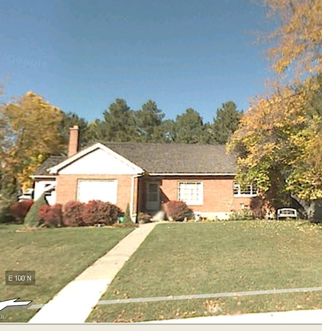 Total Photos: 1
|
| |
|
|
| Property Address: 921 E 100 NORTH - PLEASANT GROVE |
|
| Mailing Address: 921 E 100 N PLEASANT GROVE, UT 84062-2507 |
|
| Acreage: 0.356728 |
|
| Last Document:
47934-2009
|
|
| Subdivision Map Filing |
|
| Taxing Description:
COM N 938.94 FT & E 1221.56 FT FR S 1/4 COR. SEC. 21, T5S, R2E, SLB&M.; E 110.22 FT; S 141.54 FT; N 89 DEG 24' 52" W 110.23 FT; N 140.42 FT TO BEG. AREA 0.357 AC.
*Taxing description NOT FOR LEGAL DOCUMENTS
|
|
- Owner Names
- Value History
- Tax History
- Location
- Photos
- Documents
- Aerial Image
| |
----- Real Estate Values ----- |
---Improvements--- |
---Greenbelt--- |
Total |
| Year |
Com |
Res |
Agr |
Tot |
Com |
Res |
Agr |
Tot |
Land |
Homesite |
Tot |
Market Value |
| 2015 |
$0 |
$98,000 |
$0 |
$98,000 |
$0 |
$129,000 |
$0 |
$129,000 |
$0 |
$0 |
$0 |
$227,000 |
| 2014 |
$0 |
$98,000 |
$0 |
$98,000 |
$0 |
$129,000 |
$0 |
$129,000 |
$0 |
$0 |
$0 |
$227,000 |
| 2013 |
$0 |
$90,300 |
$0 |
$90,300 |
$0 |
$113,500 |
$0 |
$113,500 |
$0 |
$0 |
$0 |
$203,800 |
| 2012 |
$0 |
$59,700 |
$0 |
$59,700 |
$0 |
$126,100 |
$0 |
$126,100 |
$0 |
$0 |
$0 |
$185,800 |
| 2011 |
$0 |
$53,500 |
$0 |
$53,500 |
$0 |
$140,100 |
$0 |
$140,100 |
$0 |
$0 |
$0 |
$193,600 |
| 2010 |
$0 |
$63,936 |
$0 |
$63,936 |
$0 |
$146,012 |
$0 |
$146,012 |
$0 |
$0 |
$0 |
$209,948 |
| Year |
General Taxes |
Adjustments |
Net Taxes |
Fees |
Payments |
Tax Balance* |
Balance Due |
Tax District |
| 2015 |
$1,445.64 |
$0.00 |
$1,445.64 |
$0.00 |
|
$0.00
|
$0.00 |
070 - PLEASANT GROVE CITY |
| 2014 |
$1,459.37 |
$0.00 |
$1,459.37 |
$0.00 |
|
$0.00
|
$0.00 |
070 - PLEASANT GROVE CITY |
| 2013 |
$1,420.07 |
$0.00 |
$1,420.07 |
$0.00 |
|
$0.00
|
$0.00 |
070 - PLEASANT GROVE CITY |
| 2012 |
$1,323.46 |
$0.00 |
$1,323.46 |
$0.00 |
|
$0.00
|
$0.00 |
070 - PLEASANT GROVE CITY |
| 2011 |
$1,370.82 |
$0.00 |
$1,370.82 |
$0.00 |
|
$0.00
|
$0.00 |
070 - PLEASANT GROVE CITY |
| 2010 |
$1,390.98 |
$0.00 |
$1,390.98 |
$0.00 |
|
$0.00
|
$0.00 |
070 - PLEASANT GROVE CITY |
* Note: Original tax amount (Does not include applicable interest and/or fees).
| Entry # |
Date |
Recorded |
Type |
Party1 (Grantor) |
Party2 (Grantee) |
| 41537-2015 |
05/13/2015 |
05/14/2015 |
BLA |
MONSON ACRES SUBDIVISION LLC |
MONSON ACRES SUBDIVISION LLC |
| 38602-2015 |
05/05/2015 |
05/05/2015 |
WD |
MONSON, THOMAS J SUCTEE (ET AL) |
MONSON ACRES SUBDIVISION LLC |
| 11382-2015 |
02/13/2015 |
02/13/2015 |
WD |
MONSON, THOMAS J SUCTEE (ET AL) |
MONSON ACRES SUBDIVISION LLC |
| 11381-2015 |
02/13/2015 |
02/13/2015 |
AF DC |
MONSON, JESSE HORACE & JESSE H AKA |
WHOM OF INTEREST |
| 11380-2015 |
02/13/2015 |
02/13/2015 |
AF DC |
MONSON, JUNE CRANNEY & JUNE C AKA |
WHOM OF INTEREST |
| 47934-2009 |
04/24/2009 |
05/01/2009 |
QCD |
MONSON, JUNE C TEE (ET AL) |
MONSON, JUNE C TEE |
| 47930-2009 |
04/24/2009 |
05/01/2009 |
QCD |
MONSON, JUNE C TEE (ET AL) |
PLEASANT GROVE CITY |
Main Menu Comments or Concerns on Value/Appraisal - Assessor's Office
Documents/Owner/Parcel information - Recorder's Office
Address Change for Tax Notice
This page was created on 1/10/2025 11:33:01 PM |