Property Information
mobile view
| Serial Number: 17:010:0188 |
Serial Life: 2006-2011 |
|
|
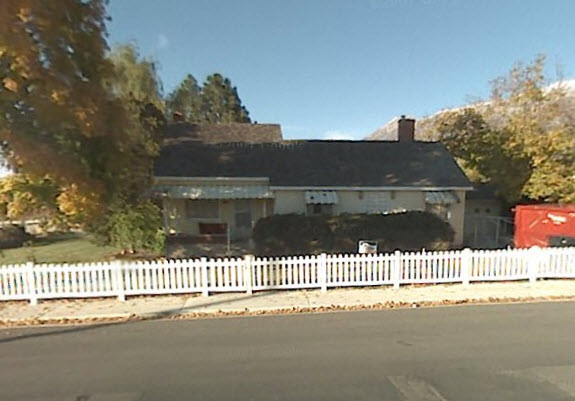
Total Photos: 1
|
| |
|
|
| Property Address: 536 W 1200 NORTH - OREM |
|
| Mailing Address: 536 W 1200 N OREM, UT 84057-2949 |
|
| Acreage: 2.206 |
|
| Last Document:
50719-2005
|
|
| Subdivision Map Filing |
|
| Taxing Description:
COM N 13.44 FT & W 1335.89 FT FR S 1/4 COR. SEC. 3, T6S, R2E, SLB&M.; N 1 DEG 18' 13" W 137.4 FT; N 1 DEG 18' 13" W 62.46 FT; N 89 DEG 35' 15" E 520.4 FT; S 76.95 FT; N 89 DEG 12' 24" E 15.82 FT; S 0 DEG 4' 56" E 117.83 FT; S 89 DEG 14' 50" W 16.35 FT; S 0 DEG 45' 10" E 6.2 FT; S 89 DEG 14' 50" W 317.22 FT; N 0 DEG 45' 10" W 101.72 FT; S 89 DEG 14' 50" W 101 FT; S 0 DEG 45' 10" E 97.68 FT; S 89 DEG 20' 10" W 97.33 FT TO BEG. AREA 2.206 AC.
*Taxing description NOT FOR LEGAL DOCUMENTS
|
|
- Owner Names
- Value History
- Tax History
- Location
- Photos
- Documents
- Aerial Image
| |
----- Real Estate Values ----- |
---Improvements--- |
---Greenbelt--- |
Total |
| Year |
Com |
Res |
Agr |
Tot |
Com |
Res |
Agr |
Tot |
Land |
Homesite |
Tot |
Market Value |
| 2011 |
$0 |
$118,200 |
$39,700 |
$157,900 |
$0 |
$129,600 |
$0 |
$129,600 |
$1,309 |
$50,000 |
$51,309 |
$287,500 |
| 2010 |
$0 |
$118,200 |
$39,700 |
$157,900 |
$0 |
$129,600 |
$0 |
$129,600 |
$1,303 |
$50,000 |
$51,303 |
$287,500 |
| 2009 |
$0 |
$118,200 |
$39,700 |
$157,900 |
$0 |
$129,600 |
$0 |
$129,600 |
$1,274 |
$50,000 |
$51,274 |
$287,500 |
| 2008 |
$0 |
$155,500 |
$52,300 |
$207,800 |
$0 |
$129,600 |
$0 |
$129,600 |
$1,264 |
$50,000 |
$51,264 |
$337,400 |
| 2007 |
$0 |
$162,000 |
$54,500 |
$216,500 |
$0 |
$135,000 |
$0 |
$135,000 |
$1,264 |
$50,000 |
$51,264 |
$351,500 |
| 2006 |
$0 |
$63,000 |
$72,600 |
$135,600 |
$0 |
$83,200 |
$0 |
$83,200 |
$1,245 |
$50,000 |
$51,245 |
$218,800 |
| Year |
General Taxes |
Adjustments |
Net Taxes |
Fees |
Payments |
Tax Balance* |
Balance Due |
Tax District |
| 2011 |
$1,251.91 |
$0.00 |
$1,251.91 |
$0.00 |
|
$0.00
|
$0.00 |
090 - OREM CITY |
| 2010 |
$1,171.97 |
$0.00 |
$1,171.97 |
$0.00 |
|
$0.00
|
$0.00 |
090 - OREM CITY |
| 2009 |
$1,086.09 |
$0.00 |
$1,086.09 |
$0.00 |
|
$0.00
|
$0.00 |
090 - OREM CITY |
| 2008 |
$1,006.34 |
$0.00 |
$1,006.34 |
$0.00 |
|
$0.00
|
$0.00 |
090 - OREM CITY |
| 2007 |
$1,024.37 |
$0.00 |
$1,024.37 |
$0.00 |
|
$0.00
|
$0.00 |
090 - OREM CITY |
| 2006 |
$788.93 |
$0.00 |
$788.93 |
$0.00 |
|
$0.00
|
$0.00 |
090 - OREM CITY |
* Note: Original tax amount (Does not include applicable interest and/or fees).
| Entry # |
Date |
Recorded |
Type |
Party1 (Grantor) |
Party2 (Grantee) |
| 32145-2011 |
04/14/2110 |
04/27/2011 |
QCD |
LOLA'S FAMILY LLC |
CITY OF OREM |
| 32144-2011 |
04/14/2011 |
04/27/2011 |
QCD |
FOWLKE, WILLIAM H & LORIE D |
CITY OF OREM |
| 32143-2011 |
04/21/2011 |
04/27/2011 |
QCD |
CITY OF OREM |
LOLA'S FAMILY LLC |
| 126390-2007 |
08/22/2007 |
08/28/2007 |
RESOL |
OREM CITY CORPORATION |
WHOM OF INTEREST |
| 30776-2007 |
03/01/2007 |
03/01/2007 |
FARM |
LOLAS FAMILY LLC (ET AL) |
WHOM OF INTEREST |
| 117818-2005 |
08/09/2005 |
10/17/2005 |
FARM |
LOLAS FAMILY LLC |
WHOM OF INTEREST |
| 50719-2005 |
05/03/2005 |
05/11/2005 |
QCD |
LOLAS FAMILY LLC |
CITY OF OREM THE |
Main Menu Comments or Concerns on Value/Appraisal - Assessor's Office
Documents/Owner/Parcel information - Recorder's Office
Address Change for Tax Notice
This page was created on 7/29/2024 3:20:05 AM |