Property Information
mobile view
| Serial Number: 17:035:0108 |
Serial Life: 2014... |
|
|
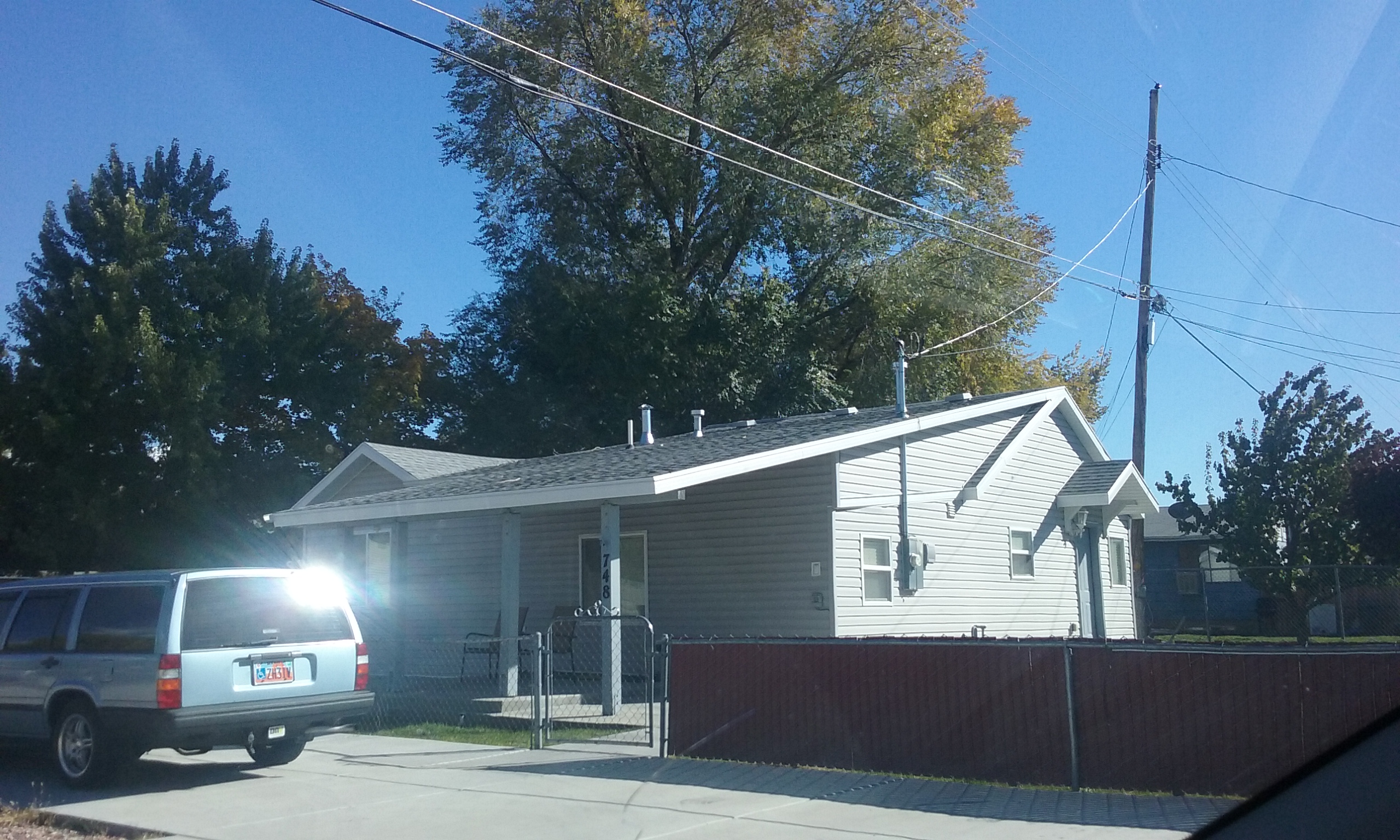
Total Photos: 1
|
| |
|
|
| Property Address: 748 N 600 WEST - OREM |
|
| Mailing Address: 750 N 600 W OREM, UT 84057-3750 |
|
| Acreage: 0.223883 |
|
| Last Document:
67689-2014
|
|
| Subdivision Map Filing |
|
| Taxing Description:
COM S 447 FT & E 1349.98 FT FR W 1/4 COR. SEC. 10, T6S, R2E, SLB&M.; N 1 DEG 10' 56" W 12 FT; E 138.14 FT; E 61.71 FT; S 0 DEG 45' 24" E 91.85 FT; N 89 DEG 40' 34" W 92.2 FT; N 1 DEG 10' 56" W 79.35 FT; W 107 FT TO BEG. AREA 0.224 AC.
*Taxing description NOT FOR LEGAL DOCUMENTS
|
|
- Owner Names
- Value History
- Tax History
- Location
- Photos
- Documents
- Aerial Image
| |
----- Real Estate Values ----- |
---Improvements--- |
---Greenbelt--- |
Total |
| Year |
Com |
Res |
Agr |
Tot |
Com |
Res |
Agr |
Tot |
Land |
Homesite |
Tot |
Market Value |
| 2024 |
$0 |
$186,400 |
$0 |
$186,400 |
$0 |
$134,400 |
$0 |
$134,400 |
$0 |
$0 |
$0 |
$320,800 |
| 2023 |
$0 |
$186,400 |
$0 |
$186,400 |
$0 |
$125,700 |
$0 |
$125,700 |
$0 |
$0 |
$0 |
$312,100 |
| 2022 |
$0 |
$198,700 |
$0 |
$198,700 |
$0 |
$127,700 |
$0 |
$127,700 |
$0 |
$0 |
$0 |
$326,400 |
| 2021 |
$0 |
$116,900 |
$0 |
$116,900 |
$0 |
$118,200 |
$0 |
$118,200 |
$0 |
$0 |
$0 |
$235,100 |
| 2020 |
$0 |
$93,500 |
$0 |
$93,500 |
$0 |
$114,800 |
$0 |
$114,800 |
$0 |
$0 |
$0 |
$208,300 |
| 2019 |
$0 |
$93,500 |
$0 |
$93,500 |
$0 |
$99,800 |
$0 |
$99,800 |
$0 |
$0 |
$0 |
$193,300 |
| 2018 |
$0 |
$89,900 |
$0 |
$89,900 |
$0 |
$86,800 |
$0 |
$86,800 |
$0 |
$0 |
$0 |
$176,700 |
| 2017 |
$0 |
$79,100 |
$0 |
$79,100 |
$0 |
$86,800 |
$0 |
$86,800 |
$0 |
$0 |
$0 |
$165,900 |
| 2016 |
$0 |
$57,600 |
$0 |
$57,600 |
$0 |
$91,000 |
$0 |
$91,000 |
$0 |
$0 |
$0 |
$148,600 |
| 2015 |
$0 |
$56,100 |
$0 |
$56,100 |
$0 |
$79,100 |
$0 |
$79,100 |
$0 |
$0 |
$0 |
$135,200 |
| 2014 |
$0 |
$55,400 |
$0 |
$55,400 |
$0 |
$68,300 |
$0 |
$68,300 |
$0 |
$0 |
$0 |
$123,700 |
| Year |
General Taxes |
Adjustments |
Net Taxes |
Fees |
Payments |
Tax Balance* |
Balance Due |
Tax District |
| 2025 |
$0.00 |
$0.00 |
$0.00 |
$0.00 |
|
$0.00
|
$0.00 |
090 - OREM CITY |
| 2024 |
$0.00 |
$0.00 |
$0.00 |
$0.00 |
|
$0.00
|
$0.00 |
090 - OREM CITY |
| 2023 |
$1,306.12 |
$0.00 |
$1,306.12 |
$0.00 |
|
$0.00
|
$0.00 |
090 - OREM CITY |
| 2022 |
$1,409.95 |
$0.00 |
$1,409.95 |
$0.00 |
|
$0.00
|
$0.00 |
090 - OREM CITY |
| 2021 |
$1,219.09 |
$0.00 |
$1,219.09 |
$0.00 |
|
$0.00
|
$0.00 |
090 - OREM CITY |
| 2020 |
$1,099.02 |
$0.00 |
$1,099.02 |
$0.00 |
|
$0.00
|
$0.00 |
090 - OREM CITY |
| 2019 |
$980.76 |
$0.00 |
$980.76 |
$0.00 |
|
$0.00
|
$0.00 |
090 - OREM CITY |
| 2018 |
$938.32 |
$0.00 |
$938.32 |
$0.00 |
|
$0.00
|
$0.00 |
090 - OREM CITY |
| 2017 |
$904.51 |
$0.00 |
$904.51 |
$0.00 |
|
$0.00
|
$0.00 |
090 - OREM CITY |
| 2016 |
$878.60 |
$0.00 |
$878.60 |
$0.00 |
|
$0.00
|
$0.00 |
090 - OREM CITY |
| 2015 |
$845.25 |
$0.00 |
$845.25 |
$0.00 |
|
$0.00
|
$0.00 |
090 - OREM CITY |
| 2014 |
$776.89 |
$0.00 |
$776.89 |
$0.00 |
|
$0.00
|
$0.00 |
090 - OREM CITY |
* Note: Original tax amount (Does not include applicable interest and/or fees).
| Entry # |
Date |
Recorded |
Type |
Party1 (Grantor) |
Party2 (Grantee) |
| 73197-2014 |
09/22/2014 |
10/13/2014 |
REC |
UNITED WEST TITLE INSURANCE AGENCY INC TEE |
PRESTWICH, SCOTT |
| 67690-2014 |
09/19/2014 |
09/22/2014 |
D TR |
BAXLEY, LESLIE A & JANE N |
USAA FEDERAL SAVINGS BANK |
| 67689-2014 |
09/19/2014 |
09/22/2014 |
WD |
PRESTWICH, SCOTT |
BAXLEY, LESLIE A & JANE N |
| 37549-2014 |
05/30/2014 |
06/03/2014 |
TR D |
PRESTWICH, SCOTT |
JOHNSON, PAUL |
| 3097-2014 |
01/14/2014 |
01/15/2014 |
SP WD |
FEDERAL NATIONAL MORTGAGE ASSOCIATION BY (ET AL) |
PRESTWICH, SCOTT |
| 51961-2013 |
05/28/2013 |
05/28/2013 |
TEE D |
HALLIDAY, PAUL M JR SUCTEE (ET AL) |
FEDERAL NATIONAL MORTGAGE ASSOCIATION |
| 44044-2013 |
05/06/2013 |
05/06/2013 |
QCD |
SOUTHWICK, TRACY & VICKIE |
SOUTHWICK, TRACY & VICKIE |
Main Menu Comments or Concerns on Value/Appraisal - Assessor's Office
Documents/Owner/Parcel information - Recorder's Office
Address Change for Tax Notice
This page was created on 7/27/2024 5:47:57 AM |