Property Information
mobile view
| Serial Number: 17:042:0043 |
Serial Life: 1981... |
|
|
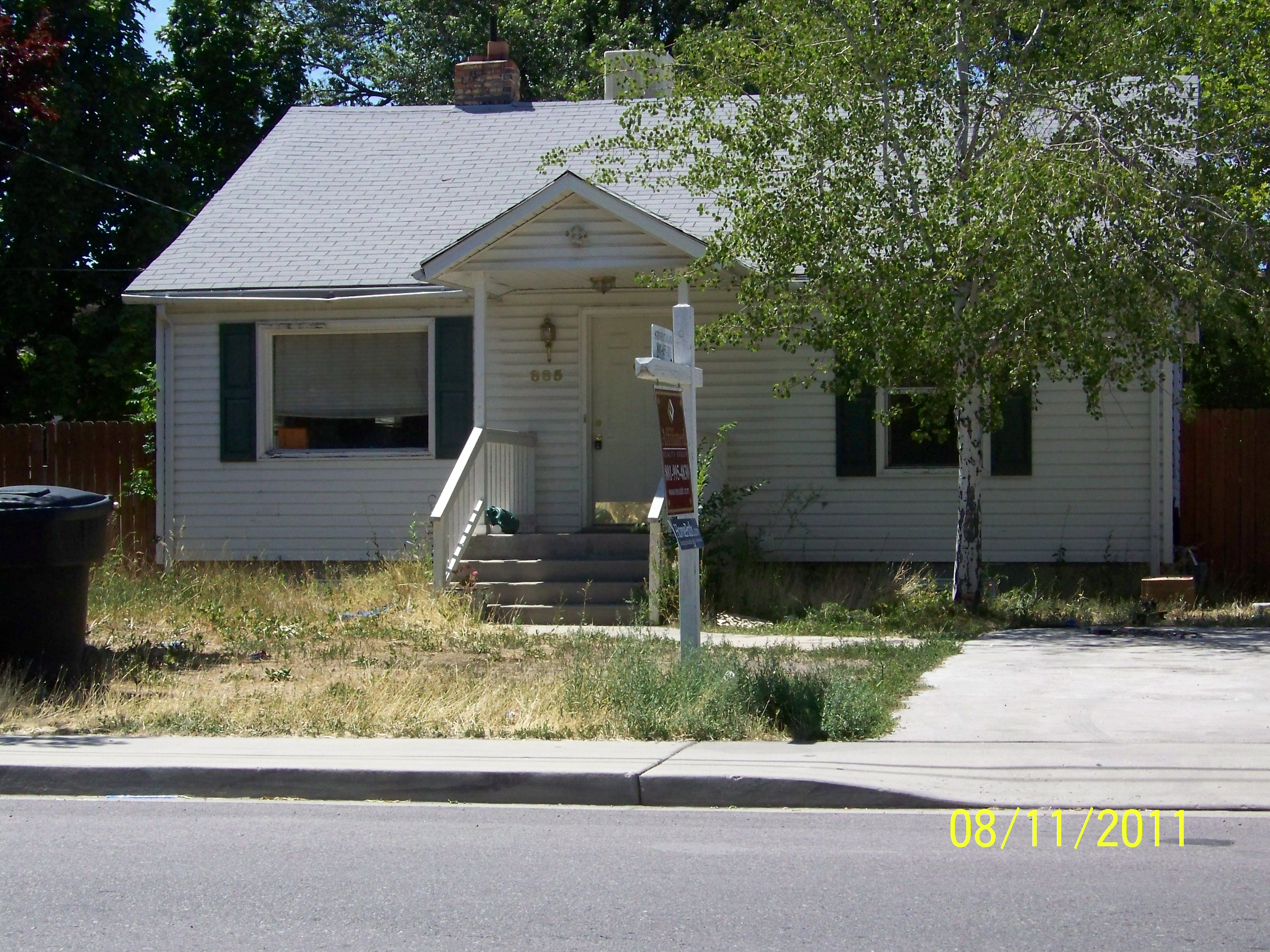 Total Photos: 2
|
| |
|
|
| Property Address: 885 N 100 WEST - OREM |
|
| Mailing Address: 885 N 100 W OREM, UT 84057-3102 |
|
| Acreage: 0.17 |
|
| Last Document:
26541-2014
|
|
| Subdivision Map Filing |
|
| Taxing Description:
COM N 38'10"W 607.75 FT & W 694.41 FT FR E1/4 COR SEC 10, T6S, R2E, SLM; S 34'11"E 57.70 FT; S 89 DEG 44'42"W 130.66 FT; N 34'11"W 57.34 FT; N 89 DEG 35'15"E 130.70 FT TO BEG. AREA .17 ACRE.
*Taxing description NOT FOR LEGAL DOCUMENTS
|
|
- Owner Names
- Value History
- Tax History
- Location
- Photos
- Documents
- Aerial Image
| 2023... |
|
CRUZ, FRANCISCO CONTRERAS |
|
| 2023... |
|
MARTINEZ, BLANCA R TORRES |
|
| 2023NV |
|
CRUZ, FRANCISCO CONTRERAS |
|
| 2015-2022 |
|
BLACK, LAURA |
|
| 2015-2022 |
|
BLACK, PETER |
|
| 2012-2014 |
|
SHEPHERD, CHELSEA |
|
| 2012NV |
|
FANNIE MAE |
|
| 2012NV |
|
FEDERAL DEPOSIT INSURANCE CORPORATION |
|
| 2008-2011 |
|
BRUNO, ADALID |
|
| 2006-2007 |
|
MORENO, OLINDA |
|
| 2005 |
|
HAGLER, BRANDON |
|
| 2005 |
|
HAGLER, RASHELL |
|
| 2004 |
|
HAGLER, BRANDON |
|
| 2004 |
|
HAGLER, MYKAL |
|
| 2004 |
|
HAGLER, TERRI |
|
| 2003 |
|
SECRETARY OF HOUSING AND URBAN DEVELOPMENT THE |
|
| 2003NV |
|
BANK OF AMERICA |
|
| 2001-2002 |
|
GULL, CODY J |
|
| 2001NV |
|
GUNSAY, MELANIE |
|
| 2000 |
|
MC CONKIE, KATHLEEN |
|
| 2000NV |
|
GUNSAY, MELANIE |
|
| 1996-1999 |
|
GUNSAY, MELANIE |
|
| 1996-1999 |
|
GUNSAY, METIN |
|
| 1995 |
|
DURRANT & PETERSON LLC |
|
| 1995NV |
|
PARCELL, HAZEL ALICE |
|
| 1992-1994 |
|
PARCELL, HAZEL S |
|
| 1986-1991 |
|
PARCELL, HAZEL S |
|
| 1981-1985 |
|
PARCELL, HAZEL S |
|
| |
----- Real Estate Values ----- |
---Improvements--- |
---Greenbelt--- |
Total |
| Year |
Com |
Res |
Agr |
Tot |
Com |
Res |
Agr |
Tot |
Land |
Homesite |
Tot |
Market Value |
| 2024 |
$0 |
$197,100 |
$0 |
$197,100 |
$0 |
$223,700 |
$0 |
$223,700 |
$0 |
$0 |
$0 |
$420,800 |
| 2023 |
$0 |
$197,100 |
$0 |
$197,100 |
$0 |
$220,900 |
$0 |
$220,900 |
$0 |
$0 |
$0 |
$418,000 |
| 2022 |
$0 |
$210,100 |
$0 |
$210,100 |
$0 |
$188,900 |
$0 |
$188,900 |
$0 |
$0 |
$0 |
$399,000 |
| 2021 |
$0 |
$131,300 |
$0 |
$131,300 |
$0 |
$156,100 |
$0 |
$156,100 |
$0 |
$0 |
$0 |
$287,400 |
| 2020 |
$0 |
$105,000 |
$0 |
$105,000 |
$0 |
$153,000 |
$0 |
$153,000 |
$0 |
$0 |
$0 |
$258,000 |
| 2019 |
$0 |
$94,800 |
$0 |
$94,800 |
$0 |
$134,700 |
$0 |
$134,700 |
$0 |
$0 |
$0 |
$229,500 |
| 2018 |
$0 |
$84,600 |
$0 |
$84,600 |
$0 |
$117,100 |
$0 |
$117,100 |
$0 |
$0 |
$0 |
$201,700 |
| 2017 |
$0 |
$77,900 |
$0 |
$77,900 |
$0 |
$102,500 |
$0 |
$102,500 |
$0 |
$0 |
$0 |
$180,400 |
| 2016 |
$0 |
$50,800 |
$0 |
$50,800 |
$0 |
$89,100 |
$0 |
$89,100 |
$0 |
$0 |
$0 |
$139,900 |
| 2015 |
$0 |
$50,800 |
$0 |
$50,800 |
$0 |
$77,500 |
$0 |
$77,500 |
$0 |
$0 |
$0 |
$128,300 |
| 2014 |
$0 |
$50,800 |
$0 |
$50,800 |
$0 |
$64,600 |
$0 |
$64,600 |
$0 |
$0 |
$0 |
$115,400 |
| 2013 |
$0 |
$44,100 |
$0 |
$44,100 |
$0 |
$59,900 |
$0 |
$59,900 |
$0 |
$0 |
$0 |
$104,000 |
| 2012 |
$0 |
$41,200 |
$0 |
$41,200 |
$0 |
$77,800 |
$0 |
$77,800 |
$0 |
$0 |
$0 |
$119,000 |
| 2011 |
$0 |
$46,400 |
$0 |
$46,400 |
$0 |
$76,800 |
$0 |
$76,800 |
$0 |
$0 |
$0 |
$123,200 |
| 2010 |
$0 |
$63,908 |
$0 |
$63,908 |
$0 |
$66,995 |
$0 |
$66,995 |
$0 |
$0 |
$0 |
$130,903 |
| 2009 |
$0 |
$72,000 |
$0 |
$72,000 |
$0 |
$61,000 |
$0 |
$61,000 |
$0 |
$0 |
$0 |
$133,000 |
| 2008 |
$0 |
$72,000 |
$0 |
$72,000 |
$0 |
$84,500 |
$0 |
$84,500 |
$0 |
$0 |
$0 |
$156,500 |
| 2007 |
$0 |
$75,000 |
$0 |
$75,000 |
$0 |
$84,500 |
$0 |
$84,500 |
$0 |
$0 |
$0 |
$159,500 |
| 2006 |
$0 |
$55,600 |
$0 |
$55,600 |
$0 |
$61,200 |
$0 |
$61,200 |
$0 |
$0 |
$0 |
$116,800 |
| 2005 |
$0 |
$52,938 |
$0 |
$52,938 |
$0 |
$58,272 |
$0 |
$58,272 |
$0 |
$0 |
$0 |
$111,210 |
| 2004 |
$0 |
$52,938 |
$0 |
$52,938 |
$0 |
$58,272 |
$0 |
$58,272 |
$0 |
$0 |
$0 |
$111,210 |
| 2003 |
$0 |
$52,938 |
$0 |
$52,938 |
$0 |
$58,272 |
$0 |
$58,272 |
$0 |
$0 |
$0 |
$111,210 |
| 2002 |
$0 |
$52,938 |
$0 |
$52,938 |
$0 |
$58,272 |
$0 |
$58,272 |
$0 |
$0 |
$0 |
$111,210 |
| 2001 |
$0 |
$52,938 |
$0 |
$52,938 |
$0 |
$58,272 |
$0 |
$58,272 |
$0 |
$0 |
$0 |
$111,210 |
| 2000 |
$0 |
$49,475 |
$0 |
$49,475 |
$0 |
$52,210 |
$0 |
$52,210 |
$0 |
$0 |
$0 |
$101,685 |
| 1999 |
$0 |
$46,238 |
$0 |
$46,238 |
$0 |
$48,794 |
$0 |
$48,794 |
$0 |
$0 |
$0 |
$95,032 |
| 1998 |
$0 |
$46,238 |
$0 |
$46,238 |
$0 |
$48,794 |
$0 |
$48,794 |
$0 |
$0 |
$0 |
$95,032 |
| 1997 |
$0 |
$46,238 |
$0 |
$46,238 |
$0 |
$48,794 |
$0 |
$48,794 |
$0 |
$0 |
$0 |
$95,032 |
| 1996 |
$0 |
$37,708 |
$0 |
$37,708 |
$0 |
$39,793 |
$0 |
$39,793 |
$0 |
$0 |
$0 |
$77,501 |
| 1995 |
$0 |
$34,280 |
$0 |
$34,280 |
$0 |
$39,793 |
$0 |
$39,793 |
$0 |
$0 |
$0 |
$74,073 |
| 1994 |
$0 |
$20,047 |
$0 |
$20,047 |
$0 |
$32,091 |
$0 |
$32,091 |
$0 |
$0 |
$0 |
$52,138 |
| 1993 |
$0 |
$20,047 |
$0 |
$20,047 |
$0 |
$32,091 |
$0 |
$32,091 |
$0 |
$0 |
$0 |
$52,138 |
| 1992 |
$0 |
$18,392 |
$0 |
$18,392 |
$0 |
$29,441 |
$0 |
$29,441 |
$0 |
$0 |
$0 |
$47,833 |
| 1991 |
$0 |
$16,133 |
$0 |
$16,133 |
$0 |
$21,199 |
$0 |
$21,199 |
$0 |
$0 |
$0 |
$37,332 |
| 1990 |
$0 |
$16,133 |
$0 |
$16,133 |
$0 |
$21,199 |
$0 |
$21,199 |
$0 |
$0 |
$0 |
$37,332 |
| 1989 |
$0 |
$16,133 |
$0 |
$16,133 |
$0 |
$21,199 |
$0 |
$21,199 |
$0 |
$0 |
$0 |
$37,332 |
| 1988 |
$0 |
$16,133 |
$0 |
$16,133 |
$0 |
$26,573 |
$0 |
$26,573 |
$0 |
$0 |
$0 |
$42,706 |
| 1987 |
$0 |
$16,133 |
$0 |
$16,133 |
$0 |
$25,900 |
$0 |
$25,900 |
$0 |
$0 |
$0 |
$42,033 |
| 1986 |
$0 |
$16,134 |
$0 |
$16,134 |
$0 |
$25,901 |
$0 |
$25,901 |
$0 |
$0 |
$0 |
$42,035 |
| 1985 |
$0 |
$16,133 |
$0 |
$16,133 |
$0 |
$25,900 |
$0 |
$25,900 |
$0 |
$0 |
$0 |
$42,033 |
| 1984 |
$0 |
$16,300 |
$0 |
$16,300 |
$0 |
$26,158 |
$0 |
$26,158 |
$0 |
$0 |
$0 |
$42,458 |
| Year |
General Taxes |
Adjustments |
Net Taxes |
Fees |
Payments |
Tax Balance* |
Balance Due |
Tax District |
| 2025 |
$0.00 |
$0.00 |
$0.00 |
$0.00 |
|
$0.00
|
$0.00 |
090 - OREM CITY |
| 2024 |
$1,892.72 |
$0.00 |
$1,892.72 |
$0.00 |
|
$0.00
|
$0.00 |
090 - OREM CITY |
| 2023 |
$1,749.31 |
$0.00 |
$1,749.31 |
$0.00 |
|
$0.00
|
$0.00 |
090 - OREM CITY |
| 2022 |
$1,723.56 |
$0.00 |
$1,723.56 |
$0.00 |
|
$0.00
|
$0.00 |
090 - OREM CITY |
| 2021 |
$1,490.28 |
$0.00 |
$1,490.28 |
$0.00 |
|
$0.00
|
$0.00 |
090 - OREM CITY |
| 2020 |
$1,361.25 |
$0.00 |
$1,361.25 |
$0.00 |
|
$0.00
|
$0.00 |
090 - OREM CITY |
| 2019 |
$1,164.43 |
$0.00 |
$1,164.43 |
$0.00 |
|
$0.00
|
$0.00 |
090 - OREM CITY |
| 2018 |
$1,071.08 |
$0.00 |
$1,071.08 |
$0.00 |
|
$0.00
|
$0.00 |
090 - OREM CITY |
| 2017 |
$983.57 |
$0.00 |
$983.57 |
$0.00 |
|
$0.00
|
$0.00 |
090 - OREM CITY |
| 2016 |
$827.16 |
$0.00 |
$827.16 |
$0.00 |
|
$0.00
|
$0.00 |
090 - OREM CITY |
| 2015 |
$802.11 |
$0.00 |
$802.11 |
$0.00 |
|
$0.00
|
$0.00 |
090 - OREM CITY |
| 2014 |
$724.76 |
$0.00 |
$724.76 |
$0.00 |
|
$0.00
|
$0.00 |
090 - OREM CITY |
| 2013 |
$704.36 |
$0.00 |
$704.36 |
$0.00 |
|
$0.00
|
$0.00 |
090 - OREM CITY |
| 2012 |
$822.58 |
$0.00 |
$822.58 |
$0.00 |
|
$0.00
|
$0.00 |
090 - OREM CITY |
| 2011 |
$847.54 |
$0.00 |
$847.54 |
$0.00 |
|
$0.00
|
$0.00 |
090 - OREM CITY |
| 2010 |
$843.07 |
$0.00 |
$843.07 |
$0.00 |
|
$0.00
|
$0.00 |
090 - OREM CITY |
| 2009 |
$794.04 |
$0.00 |
$794.04 |
$0.00 |
|
$0.00
|
$0.00 |
090 - OREM CITY |
| 2008 |
$865.83 |
$0.00 |
$865.83 |
$0.00 |
|
$0.00
|
$0.00 |
090 - OREM CITY |
| 2007 |
$872.34 |
$0.00 |
$872.34 |
$0.00 |
|
$0.00
|
$0.00 |
090 - OREM CITY |
| 2006 |
$680.24 |
$0.00 |
$680.24 |
$0.00 |
|
$0.00
|
$0.00 |
090 - OREM CITY |
| 2005 |
$731.06 |
$0.00 |
$731.06 |
$0.00 |
|
$0.00
|
$0.00 |
090 - OREM CITY |
| 2004 |
$718.09 |
$0.00 |
$718.09 |
$0.00 |
|
$0.00
|
$0.00 |
090 - OREM CITY |
| 2003 |
$696.80 |
$0.00 |
$696.80 |
$0.00 |
|
$0.00
|
$0.00 |
090 - OREM CITY |
| 2002 |
$636.80 |
$0.00 |
$636.80 |
$0.00 |
|
$0.00
|
$0.00 |
090 - OREM CITY |
| 2001 |
$630.68 |
$0.00 |
$630.68 |
$0.00 |
|
$0.00
|
$0.00 |
090 - OREM CITY |
| 2000 |
$596.24 |
$0.00 |
$596.24 |
$0.00 |
|
$0.00
|
$0.00 |
090 - OREM CITY |
| 1999 |
$573.69 |
$0.00 |
$573.69 |
$0.00 |
|
$0.00
|
$0.00 |
090 - OREM CITY |
| 1998 |
$541.71 |
$0.00 |
$541.71 |
$0.00 |
|
$0.00
|
$0.00 |
090 - OREM CITY |
| 1997 |
$539.46 |
$0.00 |
$539.46 |
$0.00 |
|
$0.00
|
$0.00 |
090 - OREM CITY |
| 1996 |
$401.91 |
$0.00 |
$401.91 |
$0.00 |
|
$0.00
|
$0.00 |
090 - OREM CITY |
| 1995 |
$434.70 |
$0.00 |
$434.70 |
$0.00 |
|
$0.00
|
$0.00 |
090 - OREM CITY |
| 1994 |
$487.49 |
($481.24) |
$6.25 |
$0.00 |
|
$0.00
|
$0.00 |
090 - OREM CITY |
| 1993 |
$431.42 |
($431.42) |
$0.00 |
$0.00 |
|
$0.00
|
$0.00 |
090 - OREM CITY |
| 1992 |
$399.06 |
($399.06) |
$0.00 |
$0.00 |
|
$0.00
|
$0.00 |
090 - OREM CITY |
| 1991 |
$325.64 |
($275.32) |
$50.32 |
$0.00 |
|
$0.00
|
$0.00 |
090 - OREM CITY |
| 1990 |
$313.03 |
$0.00 |
$313.03 |
$0.00 |
|
$0.00
|
$0.00 |
090 - OREM CITY |
| 1989 |
$319.03 |
$0.00 |
$319.03 |
$0.00 |
|
$0.00
|
$0.00 |
090 - OREM CITY |
| 1988 |
$364.09 |
$0.00 |
$364.09 |
$0.00 |
|
$0.00
|
$0.00 |
090 - OREM CITY |
| 1987 |
$352.42 |
$0.00 |
$352.42 |
$0.00 |
|
$0.00
|
$0.00 |
090 - OREM CITY |
| 1986 |
$347.68 |
$0.00 |
$347.68 |
$0.00 |
|
$0.00
|
$0.00 |
090 - OREM CITY |
| 1985 |
$349.75 |
$0.00 |
$349.75 |
$0.00 |
|
$0.00
|
$0.00 |
090 - OREM CITY |
| 1984 |
$346.51 |
$0.00 |
$346.51 |
$0.00 |
|
$0.00
|
$0.00 |
090 - OREM CITY |
* Note: Original tax amount (Does not include applicable interest and/or fees).
| Entry # |
Date |
Recorded |
Type |
Party1 (Grantor) |
Party2 (Grantee) |
| 98501-2022 |
07/11/2022 |
09/08/2022 |
REC |
ANDREWS INVESTORS INC |
BLACK, PETER & LAURA |
| 98500-2022 |
07/11/2022 |
09/08/2022 |
SUB TEE |
ANDREWS INVESTORS INC |
ANDREWS INVESTORS INC TEE |
| 97458-2022 |
09/01/2022 |
09/02/2022 |
WD |
CRUZ, FRANCISCO CONTRERAS |
CRUZ, FRANCISCO CONTRERAS (ET AL) |
| 97457-2022 |
09/01/2022 |
09/02/2022 |
D TR |
CRUZ, FRANCISCO CONTRERAS |
ROCKET MORTGAGE LLC FKA (ET AL) |
| 97272-2022 |
07/27/2022 |
09/02/2022 |
WD |
BLACK, PETER & LAURA |
CRUZ, FRANCISCO CONTRERAS |
| 40935-2014 |
06/12/2014 |
06/16/2014 |
RSUBTEE |
MORTGAGE ELECTRONIC REGISTRATION SYSTEMS INC (ET AL) |
SHEPHERD, CHELSEA |
| 40934-2014 |
06/12/2014 |
06/16/2014 |
RSUBTEE |
MORTGAGE ELECTRONIC REGISTRATION SYSTEMS INC (ET AL) |
SHEPHERD, CHELSEA |
| 26542-2014 |
04/22/2014 |
04/22/2014 |
TR D |
BLACK, PETER & LAURA |
ANDREWS INVESTORS INC |
| 26541-2014 |
04/21/2014 |
04/22/2014 |
WD |
SHEPHERD, CHELSEA |
BLACK, PETER & LAURA |
| 58221-2011 |
08/12/2011 |
08/17/2011 |
D TR |
SHEPHERD, CHELSEA |
SECURITY HOME MORTGAGE LLC |
| 58220-2011 |
08/12/2011 |
08/17/2011 |
D TR |
SHEPHERD, CHELSEA |
SECURITY HOME MORTGAGE LLC |
| 58219-2011 |
08/15/2011 |
08/17/2011 |
SP WD |
FANNIE MAE AKA (ET AL) |
SHEPHERD, CHELSEA |
| 58086-2011 |
08/16/2011 |
08/17/2011 |
R NOT |
CITY OF OREM |
WHOM OF INTEREST |
| 15529-2011 |
02/19/2011 |
02/22/2011 |
TEE D |
WOODALL, JAMES H SUCTEE (ET AL) |
FANNIE MAE AKA (ET AL) |
| 116009-2009 |
11/05/2009 |
11/06/2009 |
ND |
WOODALL, JAMES H TEE |
BRUNO, ADALID |
| 116008-2009 |
11/05/2009 |
11/06/2009 |
SUB TEE |
BANK OF AMERICA |
WOODALL, JAMES H SUCTEE |
| 62631-2008 |
05/08/2008 |
05/29/2008 |
N |
CITY OF OREM |
WHOM OF INTEREST |
| 170978-2007 |
12/06/2007 |
12/11/2007 |
RSUBTEE |
BANK OF AMERICA (ET AL) |
BRUNO, ADALID |
| 159809-2007 |
11/07/2007 |
11/09/2007 |
D TR |
BRUNO, ADALID |
BANK OF AMERICA |
| 69896-2007 |
04/20/2007 |
05/11/2007 |
REC |
HALLIDAY, PAUL M TEE |
MORENO, OLINDA |
| 69895-2007 |
04/20/2007 |
05/11/2007 |
SUB TEE |
EMC MORTGAGE CORPORATION |
HALLIDAY, PAUL M SUCTEE |
| 59123-2007 |
04/20/2007 |
04/23/2007 |
CAN ND |
FIRST SOUTHWESTERN TITLE AGENCY OF UTAH INC SUCTEE |
WHOM OF INTEREST |
| 58092-2007 |
04/11/2007 |
04/20/2007 |
RSUBTEE |
OCWEN FINANCIAL SERVICES INC (ET AL) |
MORENO, OLINDA |
| 58091-2007 |
04/11/2007 |
04/20/2007 |
LOSTDOC |
OCWEN FINANCIAL SERVICES INC |
WHOM OF INTEREST |
| 57728-2007 |
04/10/2007 |
04/19/2007 |
SUB TEE |
HSBC BANK |
FIRST SOUTHWESTERN TITLE AGENCY SUCTEE |
| 49370-2007 |
04/03/2007 |
04/04/2007 |
CAN ND |
HALLIDAY, PAUL M JR SUCTEE |
MORENO, OLINDA |
| 48644-2007 |
03/23/2007 |
04/03/2007 |
D TR |
BRUNO, ADALID |
BANK OF AMERICA |
| 48512-2007 |
03/27/2007 |
04/03/2007 |
WD |
MORENO, OLINDA |
BRUNO, ADALID |
| 40303-2007 |
03/20/2007 |
03/20/2007 |
ND |
FIRST SOUTHWESTERN TITLE AGENCY OF UTAH INC SUCTEE |
MORENO, OLINDA |
| 20794-2007 |
01/30/2007 |
02/09/2007 |
SUB TEE |
EMC MORTGAGE CORPORATION |
HALLIDAY, PAUL M JR SUCTEE |
| 14361-2007 |
01/29/2007 |
01/29/2007 |
ND |
HALLIDAY, PAUL M JR SUCTEE |
MORENO, OLINDA |
| 17300-2006 |
11/02/2005 |
02/13/2006 |
AS |
RESIDENTIAL MORTGAGE & INVESTMENT INC |
LONG BEACH MORTGAGE COMPANY |
| 17299-2006 |
11/02/2005 |
02/13/2006 |
AS |
RESIDENTIAL MORTGAGE & INVESTMENT INC |
LONG BEACH MORTGAGE COMPANY |
| 147887-2005 |
12/05/2005 |
12/22/2005 |
RSUBTEE |
COUNTRYWIDE HOME LOANS INC |
RECON TRUST COMPANY |
| 147886-2005 |
12/23/2004 |
12/22/2005 |
AS |
FIRST FRANKLIN FINANCIAL CORPORATION |
WHOM OF INTEREST |
| 127532-2005 |
11/01/2005 |
11/04/2005 |
D TR |
MORENO, OLINDA |
RESIDENTIAL MORTGAGE & INVESTMENT INC |
| 127531-2005 |
11/01/2005 |
11/04/2005 |
D TR |
MORENO, OLINDA |
RESIDENTIAL MORTGAGE & INVESTMENT INC |
| 127485-2005 |
10/20/2005 |
11/04/2005 |
WD |
HAGLER, RASHELL & BRANDON |
MORENO, OLINDA |
| 127484-2005 |
10/01/2005 |
11/04/2005 |
PA |
HAGLER, BRANDON M |
HAGLER, RASHELL L |
| 1016-2005 |
12/29/2004 |
01/04/2005 |
REC |
PRINCIPAL LIFE INS CO TEE |
HAGLER, BRANDON & MYKAL (ET AL) |
| 1015-2005 |
12/29/2004 |
01/04/2005 |
SUB TEE |
MORTGAGE ELECTRONIC REGISTRATION SYSTEMS INC |
PRINCIPAL LIFE INS CO SUCTEE |
| 140615-2004 |
12/10/2004 |
12/15/2004 |
D TR |
HAGLER, RASHELL & BRANDON |
FIRST FRANKLIN FINANCIAL CORP |
| 140614-2004 |
12/10/2004 |
12/15/2004 |
QCD |
HAGLER, MYKAL & TERRI |
HAGLER, RASHELL & BRANDON |
| 131766-2003 |
08/14/2003 |
08/15/2003 |
D TR |
HAGLER, BRANDON & MYKAL (ET AL) |
AMERICAN HERITAGE MORTGAGE LLC |
| 131765-2003 |
08/11/2003 |
08/15/2003 |
DEED |
SECRETARY OF HOUSING AND URBAN DEVELOPMENT THE |
HAGLER, BRANDON & MYKAL (ET AL) |
| 133073-2002 |
11/05/2002 |
11/06/2002 |
SP WD |
BANK OF AMERICA |
SECRETARY OF HOUSING AND URBAN DEVELOPMENT THE |
| 85280-2002 |
07/23/2002 |
07/26/2002 |
TEE D |
LUNDBERG, SCOTT TEE (ET AL) |
BANK OF AMERICA |
| 33691-2002 |
03/19/2002 |
03/26/2002 |
ND |
LUNDBERG, SCOTT TEE |
GULL, CODY J |
| 33690-2002 |
03/19/2002 |
03/26/2002 |
SUB TEE |
BANK OF AMERICA |
LUNDBERG, SCOTT SUCTEE |
| 25322-2000 |
03/24/2000 |
03/31/2000 |
REC |
CHICAGO TITLE INSURANCE COMPANY SUCTEE |
GUNSAY, METIN & MELANIE |
| 25321-2000 |
03/17/2000 |
03/31/2000 |
SUB TEE |
COUNTRYWIDE HOME LOANS INC FKA (ET AL) |
CHICAGO TITLE INSURANCE COMPANY SUCTEE |
| 24255-2000 |
03/16/2000 |
03/28/2000 |
AS |
ZIONS MORTGAGE COMPANY |
BANK OF AMERICA |
| 15891-2000 |
02/28/2000 |
02/29/2000 |
D TR |
GULL, CODY J |
ZIONS MORTGAGE COMPANY |
| 15890-2000 |
02/25/2000 |
02/29/2000 |
WD |
GUNSAY, MELANIE |
GULL, CODY J |
| 11271-2000 |
02/08/2000 |
02/11/2000 |
QCD |
MC CONKIE, KATHLEEN |
GUNSAY, MELANIE |
| 126363-1999 |
12/06/1999 |
12/06/1999 |
QCD |
GUNSAY, MELANIE |
MC CONKIE, KATHLEEN |
| 86006-1999 |
07/30/1999 |
07/30/1999 |
QCD |
GUNSAY, METIN |
GUNSAY, MELANIE |
| 67306-1995 |
03/30/1995 |
10/05/1995 |
AS |
COM UNITY LENDING INC |
COUNTRYWIDE FUNDING CORPORATION |
| 20521-1995 |
03/31/1995 |
04/04/1995 |
D TR |
GUNSAY, METIN & MELANIE |
COM UNITY LENDING INC |
| 20520-1995 |
03/31/1995 |
04/04/1995 |
WD |
DURRANT & PETERSON LLC |
GUNSAY, METIN & MELANIE |
| 96818-1994 |
12/22/1994 |
12/27/1994 |
WD |
PARACELL HAZEL ALICE TRUST (ET AL) |
DURRANT & PETERSON LLC |
| 86582-1994 |
10/07/1994 |
11/10/1994 |
QCD |
PARCELL, HAZEL S |
PARCELL, HAZEL ALICE TEE |
| 50610-1991 |
11/26/1991 |
12/23/1991 |
QCD |
OREM CITY OF |
PARCELL, HAZEL S |
| 49201-1991 |
11/26/1991 |
12/12/1991 |
QCD |
OREM CITY OF |
PARCELL, HAZEL S |
| 5929-1985 |
02/12/1985 |
03/06/1985 |
BLA |
CONDIE, MIKE (ET AL) |
WILBERG, CHAL B (ET AL) |
Main Menu Comments or Concerns on Value/Appraisal - Assessor's Office
Documents/Owner/Parcel information - Recorder's Office
Address Change for Tax Notice
This page was created on 4/6/2025 6:01:53 PM |
