Property Information
mobile view
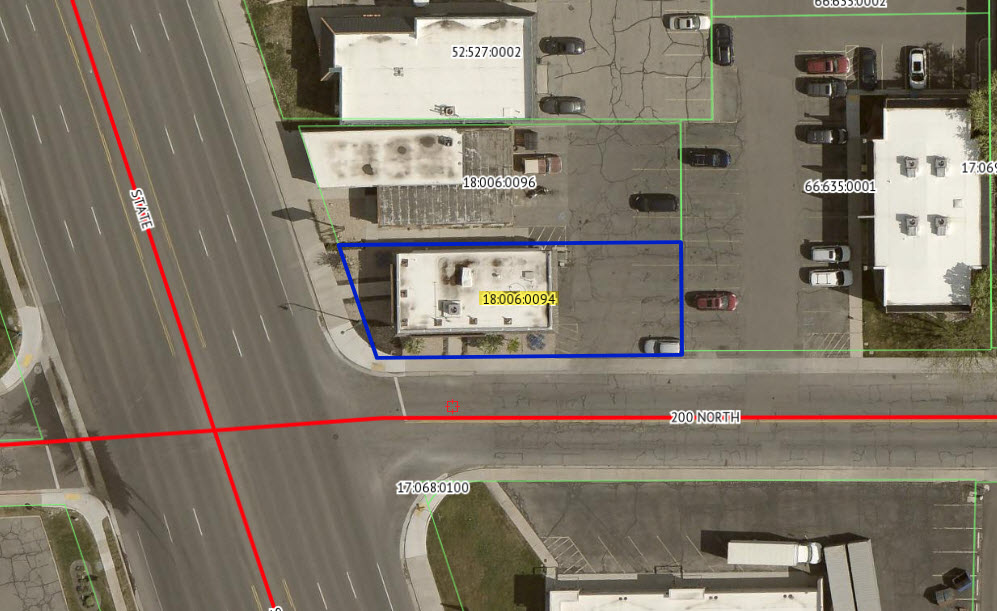
| Serial Number: 18:006:0094 |
Serial Life: 2017... |
|
|
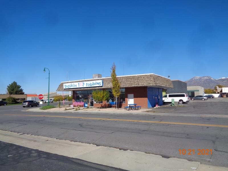
 Total Photos: 8
|
| |
|
|
| Property Address: 10 W 200 NORTH - OREM |
|
| Mailing Address: 1756 S CARSON WAY SALEM, UT 84653 |
|
| Acreage: 0.121838 |
|
| Last Document:
49360-2016
|
|
| Subdivision Map Filing |
|
| Taxing Description:
COM S 1327.7 FT & W 81.95 FT FR NE COR. SEC. 15, T6S, R2E, SLB&M.; S 89 DEG 41' 0" W 116.59 FT; N 18 DEG 33' 30" W 45.2 FT; N 89 DEG 41' 0" E 130.81 FT; S 0 DEG 13' 35" E 42.93 FT TO BEG. AREA 0.122 AC.
*Taxing description NOT FOR LEGAL DOCUMENTS
|
|
- Owner Names
- Value History
- Tax History
- Location
- Photos
- Documents
- Aerial Image
| |
----- Real Estate Values ----- |
---Improvements--- |
---Greenbelt--- |
Total |
| Year |
Com |
Res |
Agr |
Tot |
Com |
Res |
Agr |
Tot |
Land |
Homesite |
Tot |
Market Value |
| 2024 |
$115,400 |
$0 |
$0 |
$115,400 |
$68,900 |
$0 |
$0 |
$68,900 |
$0 |
$0 |
$0 |
$184,300 |
| 2023 |
$109,200 |
$0 |
$0 |
$109,200 |
$65,500 |
$0 |
$0 |
$65,500 |
$0 |
$0 |
$0 |
$174,700 |
| 2022 |
$108,100 |
$0 |
$0 |
$108,100 |
$67,200 |
$0 |
$0 |
$67,200 |
$0 |
$0 |
$0 |
$175,300 |
| 2021 |
$103,200 |
$0 |
$0 |
$103,200 |
$69,100 |
$0 |
$0 |
$69,100 |
$0 |
$0 |
$0 |
$172,300 |
| 2020 |
$103,200 |
$0 |
$0 |
$103,200 |
$60,900 |
$0 |
$0 |
$60,900 |
$0 |
$0 |
$0 |
$164,100 |
| 2019 |
$93,800 |
$0 |
$0 |
$93,800 |
$61,600 |
$0 |
$0 |
$61,600 |
$0 |
$0 |
$0 |
$155,400 |
| 2018 |
$88,500 |
$0 |
$0 |
$88,500 |
$49,700 |
$0 |
$0 |
$49,700 |
$0 |
$0 |
$0 |
$138,200 |
| 2017 |
$84,300 |
$0 |
$0 |
$84,300 |
$49,700 |
$0 |
$0 |
$49,700 |
$0 |
$0 |
$0 |
$134,000 |
| Year |
General Taxes |
Adjustments |
Net Taxes |
Fees |
Payments |
Tax Balance* |
Balance Due |
Tax District |
| 2025 |
$0.00 |
$0.00 |
$0.00 |
$0.00 |
|
$0.00
|
$0.00 |
090 - OREM CITY |
| 2024 |
$1,507.21 |
$0.00 |
$1,507.21 |
$0.00 |
|
|
Click for Payoff
|
090 - OREM CITY |
| 2023 |
$1,329.29 |
$0.00 |
$1,329.29 |
$0.00 |
|
$0.00
|
$0.00 |
090 - OREM CITY |
| 2022 |
$1,376.81 |
$0.00 |
$1,376.81 |
$0.00 |
|
$0.00
|
$0.00 |
090 - OREM CITY |
| 2021 |
$1,624.44 |
$0.00 |
$1,624.44 |
$0.00 |
|
$0.00
|
$0.00 |
090 - OREM CITY |
| 2020 |
$1,574.21 |
$0.00 |
$1,574.21 |
$0.00 |
|
$0.00
|
$0.00 |
090 - OREM CITY |
| 2019 |
$1,433.57 |
$0.00 |
$1,433.57 |
$0.00 |
|
$0.00
|
$0.00 |
090 - OREM CITY |
| 2018 |
$1,334.32 |
$0.00 |
$1,334.32 |
$0.00 |
|
$0.00
|
$0.00 |
090 - OREM CITY |
| 2017 |
$1,328.34 |
$0.00 |
$1,328.34 |
$0.00 |
|
$0.00
|
$0.00 |
090 - OREM CITY |
* Note: Original tax amount (Does not include applicable interest and/or fees).
| Entry # |
Date |
Recorded |
Type |
Party1 (Grantor) |
Party2 (Grantee) |
| 162059-2021 |
09/16/2021 |
09/20/2021 |
REC |
WELLS FARGO TRUST COMPANY TEE |
WHOSHH PROPERTIES LLC |
| 139655-2019 |
12/09/2019 |
12/31/2019 |
EAS |
200 BLOCK PROPERTIES LLC |
UTAH DEPARTMENT OF TRANSPORTATION |
| 53357-2016 |
06/10/2016 |
06/13/2016 |
SUB AGR |
HOME CARE MANAGEMENT LLC (ET AL) |
WELLS FARGO BANK |
| 53356-2016 |
06/10/2016 |
06/13/2016 |
D TR |
WHOSHH PROPERTIES LLC |
WELLS FARGO BANK |
| 53355-2016 |
06/10/2016 |
06/13/2016 |
SP WD |
DODGE FAMILY PROPERTIES LLC |
WHOSHH PROPERTIES LLC |
| 49360-2016 |
05/26/2016 |
06/01/2016 |
QCD |
200 BLOCK PROPERTIES LLC |
DODGE FAMILY PROPERTIES LLC |
Main Menu Comments or Concerns on Value/Appraisal - Assessor's Office
Documents/Owner/Parcel information - Recorder's Office
Address Change for Tax Notice
This page was created on 10/20/2024 1:47:30 PM |