Property Information
mobile view
| Serial Number: 19:010:0026 |
Serial Life: 1981-2005 |
|
|
 Total Photos: 2
|
| |
|
|
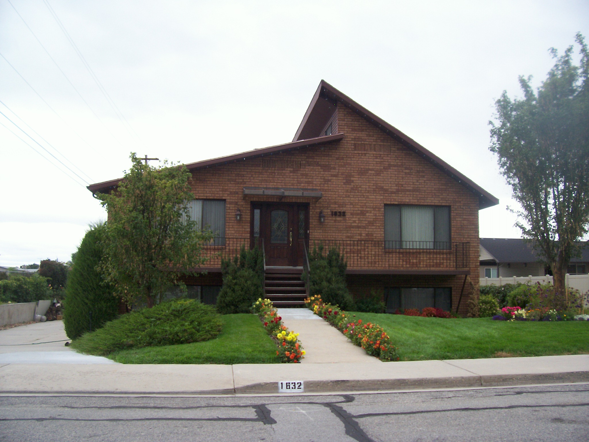
| Property Address: 1632 S 200 EAST - OREM |
|
| Mailing Address: 1632 S 200 E OREM, UT 84058-7805 |
|
| Acreage: 0.27 |
|
| Last Document:
42991-2004
|
|
| Subdivision Map Filing |
|
| Taxing Description:
COM E 1158.79 FT & S 163.43 FT FR W1/4 COR SEC 26, T6S, R2E, SLM; S 89-10'10"E 145 FT; S 45'22"E 80 FT; N 89-16'10"W 145 FT; N 45'22"W 80 FT TO BEG. AREA .27 ACRES.
*Taxing description NOT FOR LEGAL DOCUMENTS
|
|
- Owner Names
- Value History
- Tax History
- Location
- Photos
- Documents
- Aerial Image
| 2005 |
|
BLACKHAM, ANGUS U |
|
| 2005 |
|
BLACKHAM, LULABELLE BAMGARTNER |
|
| 2005NV |
|
BLACKHAM, ANGUS U |
|
| 2005NV |
|
BLACKHAM, LULABELLE BAMGARTNER |
|
| 1994-2004 |
|
BLACKHAM, ANGUS U |
|
| 1994-2004 |
|
BLACKHAM, LULABELLE BAMGARTNER |
|
| 1983-1993 |
|
BLACKHAM, ANGUS U |
|
| 1983-1993 |
|
BLACKHAM, L B |
|
| 1981-1982 |
|
BLACKHAM, ANGUS U |
|
| 1981-1982 |
|
BLACKHAM, L B |
|
| |
----- Real Estate Values ----- |
---Improvements--- |
---Greenbelt--- |
Total |
| Year |
Com |
Res |
Agr |
Tot |
Com |
Res |
Agr |
Tot |
Land |
Homesite |
Tot |
Market Value |
| 2005 |
$0 |
$49,588 |
$0 |
$49,588 |
$0 |
$193,011 |
$0 |
$193,011 |
$0 |
$0 |
$0 |
$242,599 |
| 2004 |
$0 |
$49,588 |
$0 |
$49,588 |
$0 |
$193,011 |
$0 |
$193,011 |
$0 |
$0 |
$0 |
$242,599 |
| 2003 |
$0 |
$49,588 |
$0 |
$49,588 |
$0 |
$193,011 |
$0 |
$193,011 |
$0 |
$0 |
$0 |
$242,599 |
| 2002 |
$0 |
$49,588 |
$0 |
$49,588 |
$0 |
$193,011 |
$0 |
$193,011 |
$0 |
$0 |
$0 |
$242,599 |
| 2001 |
$0 |
$49,588 |
$0 |
$49,588 |
$0 |
$193,011 |
$0 |
$193,011 |
$0 |
$0 |
$0 |
$242,599 |
| 2000 |
$0 |
$46,344 |
$0 |
$46,344 |
$0 |
$180,468 |
$0 |
$180,468 |
$0 |
$0 |
$0 |
$226,812 |
| 1999 |
$0 |
$43,312 |
$0 |
$43,312 |
$0 |
$168,662 |
$0 |
$168,662 |
$0 |
$0 |
$0 |
$211,974 |
| 1998 |
$0 |
$43,312 |
$0 |
$43,312 |
$0 |
$168,662 |
$0 |
$168,662 |
$0 |
$0 |
$0 |
$211,974 |
| 1997 |
$0 |
$43,312 |
$0 |
$43,312 |
$0 |
$168,662 |
$0 |
$168,662 |
$0 |
$0 |
$0 |
$211,974 |
| 1996 |
$0 |
$40,033 |
$0 |
$40,033 |
$0 |
$155,894 |
$0 |
$155,894 |
$0 |
$0 |
$0 |
$195,927 |
| 1995 |
$0 |
$36,394 |
$0 |
$36,394 |
$0 |
$155,894 |
$0 |
$155,894 |
$0 |
$0 |
$0 |
$192,288 |
| 1994 |
$0 |
$21,283 |
$0 |
$21,283 |
$0 |
$125,721 |
$0 |
$125,721 |
$0 |
$0 |
$0 |
$147,004 |
| 1993 |
$0 |
$21,283 |
$0 |
$21,283 |
$0 |
$125,721 |
$0 |
$125,721 |
$0 |
$0 |
$0 |
$147,004 |
| 1992 |
$0 |
$19,526 |
$0 |
$19,526 |
$0 |
$115,340 |
$0 |
$115,340 |
$0 |
$0 |
$0 |
$134,866 |
| 1991 |
$0 |
$17,128 |
$0 |
$17,128 |
$0 |
$103,265 |
$0 |
$103,265 |
$0 |
$0 |
$0 |
$120,393 |
| 1990 |
$0 |
$17,128 |
$0 |
$17,128 |
$0 |
$103,265 |
$0 |
$103,265 |
$0 |
$0 |
$0 |
$120,393 |
| 1989 |
$0 |
$17,128 |
$0 |
$17,128 |
$0 |
$103,265 |
$0 |
$103,265 |
$0 |
$0 |
$0 |
$120,393 |
| 1988 |
$0 |
$17,128 |
$0 |
$17,128 |
$0 |
$103,265 |
$0 |
$103,265 |
$0 |
$0 |
$0 |
$120,393 |
| 1987 |
$0 |
$17,658 |
$0 |
$17,658 |
$0 |
$106,458 |
$0 |
$106,458 |
$0 |
$0 |
$0 |
$124,116 |
| 1986 |
$0 |
$17,659 |
$0 |
$17,659 |
$0 |
$106,460 |
$0 |
$106,460 |
$0 |
$0 |
$0 |
$124,119 |
| 1985 |
$0 |
$17,658 |
$0 |
$17,658 |
$0 |
$106,458 |
$0 |
$106,458 |
$0 |
$0 |
$0 |
$124,116 |
| 1984 |
$0 |
$17,833 |
$0 |
$17,833 |
$0 |
$107,533 |
$0 |
$107,533 |
$0 |
$0 |
$0 |
$125,366 |
| Year |
General Taxes |
Adjustments |
Net Taxes |
Fees |
Payments |
Tax Balance* |
Balance Due |
Tax District |
| 2005 |
$1,594.74 |
$0.00 |
$1,594.74 |
$0.00 |
|
$0.00
|
$0.00 |
090 - OREM CITY |
| 2004 |
$1,566.46 |
$0.00 |
$1,566.46 |
$0.00 |
|
$0.00
|
$0.00 |
090 - OREM CITY |
| 2003 |
$1,520.02 |
$0.00 |
$1,520.02 |
$0.00 |
|
$0.00
|
$0.00 |
090 - OREM CITY |
| 2002 |
$1,389.13 |
$0.00 |
$1,389.13 |
$0.00 |
|
$0.00
|
$0.00 |
090 - OREM CITY |
| 2001 |
$1,375.79 |
$0.00 |
$1,375.79 |
$0.00 |
|
$0.00
|
$0.00 |
090 - OREM CITY |
| 2000 |
$1,329.92 |
$0.00 |
$1,329.92 |
$0.00 |
|
$0.00
|
$0.00 |
090 - OREM CITY |
| 1999 |
$1,279.65 |
$0.00 |
$1,279.65 |
$0.00 |
|
$0.00
|
$0.00 |
090 - OREM CITY |
| 1998 |
$1,208.30 |
$0.00 |
$1,208.30 |
$0.00 |
|
$0.00
|
$0.00 |
090 - OREM CITY |
| 1997 |
$1,203.28 |
$0.00 |
$1,203.28 |
$0.00 |
|
$0.00
|
$0.00 |
090 - OREM CITY |
| 1996 |
$1,016.07 |
$0.00 |
$1,016.07 |
$0.00 |
|
$0.00
|
$0.00 |
090 - OREM CITY |
| 1995 |
$1,128.45 |
$0.00 |
$1,128.45 |
$0.00 |
|
$0.00
|
$0.00 |
090 - OREM CITY |
| 1994 |
$1,374.48 |
$0.00 |
$1,374.48 |
$0.00 |
|
$0.00
|
$0.00 |
090 - OREM CITY |
| 1993 |
$1,216.42 |
$0.00 |
$1,216.42 |
$0.00 |
|
$0.00
|
$0.00 |
090 - OREM CITY |
| 1992 |
$1,125.17 |
$0.00 |
$1,125.17 |
$0.00 |
|
$0.00
|
$0.00 |
090 - OREM CITY |
| 1991 |
$1,050.14 |
$0.00 |
$1,050.14 |
$0.00 |
|
$0.00
|
$0.00 |
090 - OREM CITY |
| 1990 |
$1,009.50 |
$0.00 |
$1,009.50 |
$0.00 |
|
$0.00
|
$0.00 |
090 - OREM CITY |
| 1989 |
$1,028.86 |
$0.00 |
$1,028.86 |
$0.00 |
|
$0.00
|
$0.00 |
090 - OREM CITY |
| 1988 |
$1,026.40 |
$0.00 |
$1,026.40 |
$0.00 |
|
$0.00
|
$0.00 |
090 - OREM CITY |
| 1987 |
$1,040.64 |
$0.00 |
$1,040.64 |
$0.00 |
|
$0.00
|
$0.00 |
090 - OREM CITY |
| 1986 |
$1,026.64 |
$0.00 |
$1,026.64 |
$0.00 |
|
$0.00
|
$0.00 |
090 - OREM CITY |
| 1985 |
$1,032.75 |
$0.00 |
$1,032.75 |
$0.00 |
|
$0.00
|
$0.00 |
090 - OREM CITY |
| 1984 |
$1,023.14 |
$0.00 |
$1,023.14 |
$0.00 |
|
$0.00
|
$0.00 |
090 - OREM CITY |
* Note: Original tax amount (Does not include applicable interest and/or fees).
| Entry # |
Date |
Recorded |
Type |
Party1 (Grantor) |
Party2 (Grantee) |
| 21492-2005 |
02/01/2005 |
03/01/2005 |
S PLAT |
BLACKHAM, ANGUS U & LULABELLE BAMGARTNER TEE (ET AL) |
EMILS ORCHARD PLAT A |
| 42991-2004 |
03/01/2004 |
04/15/2004 |
WD |
BLACKHAM, ANGUS U & LULABELLE BAMGARTNER |
BLACKHAM, ANGUS U & LULABELLE BAMGARTNER TEE |
| 42990-2004 |
04/12/2004 |
04/15/2004 |
D TR |
BLACKHAM, ANGUS U & LULA BELLE BAMGARTNER |
UTAH COMMUNITY CREDIT UNION |
| 42989-2004 |
03/01/2004 |
04/15/2004 |
WD |
BLACKHAM, ANGUS U & LULABELLE BAMGARTNER TEE (ET AL) |
BLACKHAM, ANGUS U & LULABELLE BAMGARTNER |
| 22100-2004 |
01/30/2004 |
02/27/2004 |
EAS AGR |
BLACKHAM, ANGUS U & LULA BELLE B |
QWEST COMMUNICATIONS |
| 20406-1993 |
04/06/1993 |
04/06/1993 |
WD |
BLACKHAM, ANGUS U & LULA BELLE (ET AL) |
BLACKHAM, ANGUS U & LULABELLE BAMGARTNER TEE |
| 19743-1982 |
03/25/1982 |
08/11/1982 |
C WD |
BAMGARTNER, EMIL & LORETTA |
BLACKHAM, ANGUS U & LULA BELLE |
Main Menu Comments or Concerns on Value/Appraisal - Assessor's Office
Documents/Owner/Parcel information - Recorder's Office
Address Change for Tax Notice
This page was created on 10/19/2024 8:49:11 PM |
