Property Information
mobile view
| Serial Number: 19:019:0006 |
Serial Life: 1981... |
|
|
 Total Photos: 6
|
| |
|
|
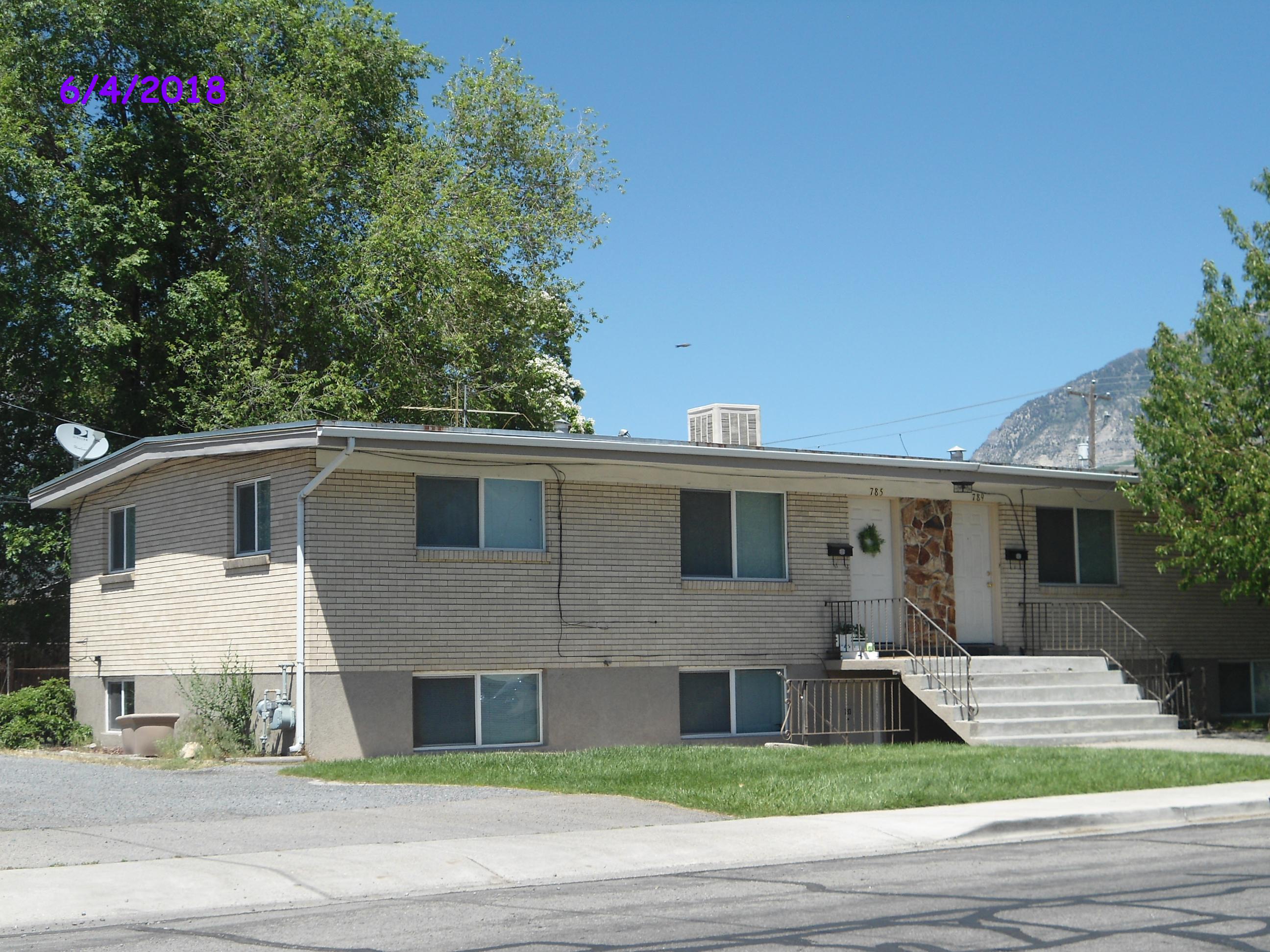
| Property Address: 783 E 1400 SOUTH - OREM
more see "Addrs" tab below..
|
|
| Mailing Address: 253 W 200 N VERNAL, UT 84078-1909 |
|
| Acreage: 0.22 |
|
| Last Document:
68415-2000
|
|
| Subdivision Map Filing |
|
| Taxing Description:
BEG. 1215.2 FT S ALONG SEC LINE & 24.75 FT W FROM NE COR OF SEC 26, T 6 S, R 2 E, SLBM; W 132 FT; S 71 FT; S 88 41' E 132 FT; N 74 FT TO BEG. AREA .22 OF AN ACRE M OR L.
*Taxing description NOT FOR LEGAL DOCUMENTS
|
|
- Owner Names
- Value History
- Tax History
- Location
- Photos
- Documents
- Aerial Image
- Addrs
| 2001... |
|
SORENSEN, BRAD A |
|
| 2001... |
|
SORENSEN, GAIL G |
|
| 1995-2000 |
|
BRIGHTON, LINDA P |
|
| 1995-2000 |
|
BRIGHTON, THOMAS B |
|
| 1993-1994 |
|
PETERSON, VIRGINIA T |
|
| 1992 |
|
PETERSON, ROBERT E |
|
| 1992 |
|
PETERSON, VIRGINIA T |
|
| 1988-1991 |
|
MC EWAN, BARBARA S |
|
| 1988-1991 |
|
MC EWAN, LLOYD C |
|
| 1981-1987 |
|
BRAITHWAITE, WAYNE |
|
| 1981-1987 |
|
MEHLHOFF, DONALD F |
|
| |
----- Real Estate Values ----- |
---Improvements--- |
---Greenbelt--- |
Total |
| Year |
Com |
Res |
Agr |
Tot |
Com |
Res |
Agr |
Tot |
Land |
Homesite |
Tot |
Market Value |
| 2024 |
$0 |
$187,000 |
$0 |
$187,000 |
$0 |
$561,000 |
$0 |
$561,000 |
$0 |
$0 |
$0 |
$748,000 |
| 2023 |
$0 |
$185,100 |
$0 |
$185,100 |
$0 |
$555,400 |
$0 |
$555,400 |
$0 |
$0 |
$0 |
$740,500 |
| 2022 |
$0 |
$195,000 |
$0 |
$195,000 |
$0 |
$487,500 |
$0 |
$487,500 |
$0 |
$0 |
$0 |
$682,500 |
| 2021 |
$0 |
$150,000 |
$0 |
$150,000 |
$0 |
$375,000 |
$0 |
$375,000 |
$0 |
$0 |
$0 |
$525,000 |
| 2020 |
$0 |
$139,900 |
$0 |
$139,900 |
$0 |
$344,200 |
$0 |
$344,200 |
$0 |
$0 |
$0 |
$484,100 |
| 2019 |
$0 |
$130,100 |
$0 |
$130,100 |
$0 |
$320,200 |
$0 |
$320,200 |
$0 |
$0 |
$0 |
$450,300 |
| 2018 |
$0 |
$256,200 |
$0 |
$256,200 |
$0 |
$165,600 |
$0 |
$165,600 |
$0 |
$0 |
$0 |
$421,800 |
| 2017 |
$0 |
$92,500 |
$0 |
$92,500 |
$0 |
$277,500 |
$0 |
$277,500 |
$0 |
$0 |
$0 |
$370,000 |
| 2016 |
$0 |
$98,200 |
$0 |
$98,200 |
$0 |
$294,400 |
$0 |
$294,400 |
$0 |
$0 |
$0 |
$392,600 |
| 2015 |
$0 |
$92,100 |
$0 |
$92,100 |
$0 |
$276,400 |
$0 |
$276,400 |
$0 |
$0 |
$0 |
$368,500 |
| 2014 |
$0 |
$81,600 |
$0 |
$81,600 |
$0 |
$244,800 |
$0 |
$244,800 |
$0 |
$0 |
$0 |
$326,400 |
| 2013 |
$0 |
$61,000 |
$0 |
$61,000 |
$0 |
$242,400 |
$0 |
$242,400 |
$0 |
$0 |
$0 |
$303,400 |
| 2012 |
$0 |
$61,000 |
$0 |
$61,000 |
$0 |
$242,400 |
$0 |
$242,400 |
$0 |
$0 |
$0 |
$303,400 |
| 2011 |
$0 |
$61,000 |
$0 |
$61,000 |
$0 |
$240,600 |
$0 |
$240,600 |
$0 |
$0 |
$0 |
$301,600 |
| 2010 |
$0 |
$66,346 |
$0 |
$66,346 |
$0 |
$253,239 |
$0 |
$253,239 |
$0 |
$0 |
$0 |
$319,585 |
| 2009 |
$0 |
$67,700 |
$0 |
$67,700 |
$0 |
$272,300 |
$0 |
$272,300 |
$0 |
$0 |
$0 |
$340,000 |
| 2008 |
$0 |
$67,700 |
$0 |
$67,700 |
$0 |
$272,300 |
$0 |
$272,300 |
$0 |
$0 |
$0 |
$340,000 |
| 2007 |
$0 |
$67,700 |
$0 |
$67,700 |
$0 |
$272,300 |
$0 |
$272,300 |
$0 |
$0 |
$0 |
$340,000 |
| 2006 |
$0 |
$67,700 |
$0 |
$67,700 |
$0 |
$100,800 |
$0 |
$100,800 |
$0 |
$0 |
$0 |
$168,500 |
| 2005 |
$0 |
$64,454 |
$0 |
$64,454 |
$0 |
$95,962 |
$0 |
$95,962 |
$0 |
$0 |
$0 |
$160,416 |
| 2004 |
$0 |
$64,454 |
$0 |
$64,454 |
$0 |
$95,962 |
$0 |
$95,962 |
$0 |
$0 |
$0 |
$160,416 |
| 2003 |
$0 |
$64,454 |
$0 |
$64,454 |
$0 |
$95,962 |
$0 |
$95,962 |
$0 |
$0 |
$0 |
$160,416 |
| 2002 |
$0 |
$64,454 |
$0 |
$64,454 |
$0 |
$95,962 |
$0 |
$95,962 |
$0 |
$0 |
$0 |
$160,416 |
| 2001 |
$0 |
$64,454 |
$0 |
$64,454 |
$0 |
$92,271 |
$0 |
$92,271 |
$0 |
$0 |
$0 |
$156,725 |
| 2000 |
$0 |
$60,237 |
$0 |
$60,237 |
$0 |
$82,385 |
$0 |
$82,385 |
$0 |
$0 |
$0 |
$142,622 |
| 1999 |
$0 |
$56,296 |
$0 |
$56,296 |
$0 |
$76,995 |
$0 |
$76,995 |
$0 |
$0 |
$0 |
$133,291 |
| 1998 |
$0 |
$56,296 |
$0 |
$56,296 |
$0 |
$76,995 |
$0 |
$76,995 |
$0 |
$0 |
$0 |
$133,291 |
| 1997 |
$0 |
$56,296 |
$0 |
$56,296 |
$0 |
$76,995 |
$0 |
$76,995 |
$0 |
$0 |
$0 |
$133,291 |
| 1996 |
$0 |
$55,431 |
$0 |
$55,431 |
$0 |
$75,812 |
$0 |
$75,812 |
$0 |
$0 |
$0 |
$131,243 |
| 1995 |
$0 |
$50,392 |
$0 |
$50,392 |
$0 |
$75,812 |
$0 |
$75,812 |
$0 |
$0 |
$0 |
$126,204 |
| 1994 |
$0 |
$29,469 |
$0 |
$29,469 |
$0 |
$61,139 |
$0 |
$61,139 |
$0 |
$0 |
$0 |
$90,608 |
| 1993 |
$0 |
$29,469 |
$0 |
$29,469 |
$0 |
$61,139 |
$0 |
$61,139 |
$0 |
$0 |
$0 |
$90,608 |
| 1992 |
$0 |
$27,036 |
$0 |
$27,036 |
$0 |
$56,091 |
$0 |
$56,091 |
$0 |
$0 |
$0 |
$83,127 |
| 1991 |
$0 |
$23,716 |
$0 |
$23,716 |
$0 |
$49,203 |
$0 |
$49,203 |
$0 |
$0 |
$0 |
$72,919 |
| 1990 |
$0 |
$23,716 |
$0 |
$23,716 |
$0 |
$49,203 |
$0 |
$49,203 |
$0 |
$0 |
$0 |
$72,919 |
| 1989 |
$0 |
$23,716 |
$0 |
$23,716 |
$0 |
$49,203 |
$0 |
$49,203 |
$0 |
$0 |
$0 |
$72,919 |
| 1988 |
$0 |
$23,717 |
$0 |
$23,717 |
$0 |
$49,203 |
$0 |
$49,203 |
$0 |
$0 |
$0 |
$72,920 |
| 1987 |
$0 |
$24,450 |
$0 |
$24,450 |
$0 |
$50,725 |
$0 |
$50,725 |
$0 |
$0 |
$0 |
$75,175 |
| 1986 |
$0 |
$24,450 |
$0 |
$24,450 |
$0 |
$50,726 |
$0 |
$50,726 |
$0 |
$0 |
$0 |
$75,176 |
| 1985 |
$0 |
$24,450 |
$0 |
$24,450 |
$0 |
$50,725 |
$0 |
$50,725 |
$0 |
$0 |
$0 |
$75,175 |
| 1984 |
$0 |
$24,700 |
$0 |
$24,700 |
$0 |
$59,675 |
$0 |
$59,675 |
$0 |
$0 |
$0 |
$84,375 |
| Year |
General Taxes |
Adjustments |
Net Taxes |
Fees |
Payments |
Tax Balance* |
Balance Due |
Tax District |
| 2025 |
$0.00 |
$0.00 |
$0.00 |
$0.00 |
|
($993.00)
|
($993.00) |
090 - OREM CITY |
| 2024 |
$3,364.43 |
$0.00 |
$3,364.43 |
$0.00 |
|
$0.00
|
$0.00 |
090 - OREM CITY |
| 2023 |
$3,098.96 |
$0.00 |
$3,098.96 |
$0.00 |
|
$0.00
|
$0.00 |
090 - OREM CITY |
| 2022 |
$2,948.20 |
$0.00 |
$2,948.20 |
$0.00 |
|
$0.00
|
$0.00 |
090 - OREM CITY |
| 2021 |
$2,722.34 |
$0.00 |
$2,722.34 |
$0.00 |
|
$0.00
|
$0.00 |
090 - OREM CITY |
| 2020 |
$2,554.18 |
$0.00 |
$2,554.18 |
$0.00 |
|
$0.00
|
$0.00 |
090 - OREM CITY |
| 2019 |
$2,284.71 |
$0.00 |
$2,284.71 |
$0.00 |
|
$0.00
|
$0.00 |
090 - OREM CITY |
| 2018 |
$2,239.86 |
$0.00 |
$2,239.86 |
$0.00 |
|
$0.00
|
$0.00 |
090 - OREM CITY |
| 2017 |
$2,017.30 |
$0.00 |
$2,017.30 |
$0.00 |
|
$0.00
|
$0.00 |
090 - OREM CITY |
| 2016 |
$2,321.25 |
$0.00 |
$2,321.25 |
$0.00 |
|
$0.00
|
$0.00 |
090 - OREM CITY |
| 2015 |
$2,303.81 |
$0.00 |
$2,303.81 |
$0.00 |
|
$0.00
|
$0.00 |
090 - OREM CITY |
| 2014 |
$2,049.94 |
$0.00 |
$2,049.94 |
$0.00 |
|
$0.00
|
$0.00 |
090 - OREM CITY |
| 2013 |
$2,054.84 |
$0.00 |
$2,054.84 |
$0.00 |
|
$0.00
|
$0.00 |
090 - OREM CITY |
| 2012 |
$2,097.22 |
$0.00 |
$2,097.22 |
$0.00 |
|
$0.00
|
$0.00 |
090 - OREM CITY |
| 2011 |
$2,074.83 |
$0.00 |
$2,074.83 |
$0.00 |
|
$0.00
|
$0.00 |
090 - OREM CITY |
| 2010 |
$2,058.28 |
$0.00 |
$2,058.28 |
$0.00 |
|
$0.00
|
$0.00 |
090 - OREM CITY |
| 2009 |
$2,029.89 |
$0.00 |
$2,029.89 |
$0.00 |
|
$0.00
|
$0.00 |
090 - OREM CITY |
| 2008 |
$1,881.03 |
$0.00 |
$1,881.03 |
$0.00 |
|
$0.00
|
$0.00 |
090 - OREM CITY |
| 2007 |
$1,867.48 |
$0.00 |
$1,867.48 |
$0.00 |
|
$0.00
|
$0.00 |
090 - OREM CITY |
| 2006 |
$989.81 |
$0.00 |
$989.81 |
$0.00 |
|
$0.00
|
$0.00 |
090 - OREM CITY |
| 2005 |
$1,064.07 |
$0.00 |
$1,064.07 |
$0.00 |
|
$0.00
|
$0.00 |
090 - OREM CITY |
| 2004 |
$1,045.20 |
$0.00 |
$1,045.20 |
$0.00 |
|
$0.00
|
$0.00 |
090 - OREM CITY |
| 2003 |
$1,014.22 |
$0.00 |
$1,014.22 |
$0.00 |
|
$0.00
|
$0.00 |
090 - OREM CITY |
| 2002 |
$926.88 |
$0.00 |
$926.88 |
$0.00 |
|
$0.00
|
$0.00 |
090 - OREM CITY |
| 2001 |
$897.05 |
$0.00 |
$897.05 |
$0.00 |
|
$0.00
|
$0.00 |
090 - OREM CITY |
| 2000 |
$844.80 |
$0.00 |
$844.80 |
$0.00 |
|
$0.00
|
$0.00 |
090 - OREM CITY |
| 1999 |
$813.43 |
$0.00 |
$813.43 |
$0.00 |
|
$0.00
|
$0.00 |
090 - OREM CITY |
| 1998 |
$768.08 |
$0.00 |
$768.08 |
$0.00 |
|
$0.00
|
$0.00 |
090 - OREM CITY |
| 1997 |
$764.89 |
$0.00 |
$764.89 |
$0.00 |
|
$0.00
|
$0.00 |
090 - OREM CITY |
| 1996 |
$688.17 |
$0.00 |
$688.17 |
$0.00 |
|
$0.00
|
$0.00 |
090 - OREM CITY |
| 1995 |
$749.17 |
$0.00 |
$749.17 |
$0.00 |
|
$0.00
|
$0.00 |
090 - OREM CITY |
| 1994 |
$858.19 |
$0.00 |
$858.19 |
$0.00 |
|
$0.00
|
$0.00 |
090 - OREM CITY |
| 1993 |
$759.65 |
$0.00 |
$759.65 |
$0.00 |
|
$0.00
|
$0.00 |
090 - OREM CITY |
| 1992 |
$703.52 |
$0.00 |
$703.52 |
$0.00 |
|
$0.00
|
$0.00 |
090 - OREM CITY |
| 1991 |
$646.49 |
$0.00 |
$646.49 |
$0.00 |
|
$0.00
|
$0.00 |
090 - OREM CITY |
| 1990 |
$622.61 |
$0.00 |
$622.61 |
$0.00 |
|
$0.00
|
$0.00 |
090 - OREM CITY |
| 1989 |
$634.55 |
$0.00 |
$634.55 |
$0.00 |
|
$0.00
|
$0.00 |
090 - OREM CITY |
| 1988 |
$633.04 |
$0.00 |
$633.04 |
$0.00 |
|
$0.00
|
$0.00 |
090 - OREM CITY |
| 1987 |
$641.48 |
$0.00 |
$641.48 |
$0.00 |
|
$0.00
|
$0.00 |
090 - OREM CITY |
| 1986 |
$632.85 |
$0.00 |
$632.85 |
$0.00 |
|
$0.00
|
$0.00 |
090 - OREM CITY |
| 1985 |
$636.61 |
$0.00 |
$636.61 |
$0.00 |
|
$0.00
|
$0.00 |
090 - OREM CITY |
| 1984 |
$699.48 |
$0.00 |
$699.48 |
$0.00 |
|
$0.00
|
$0.00 |
090 - OREM CITY |
* Note: Original tax amount (Does not include applicable interest and/or fees).
| Entry # |
Date |
Recorded |
Type |
Party1 (Grantor) |
Party2 (Grantee) |
| 17490-2015 |
03/02/2015 |
03/04/2015 |
RSUBTEE |
MORTGAGE ELECTRONIC REGISTRATION SYSTEMS INC (ET AL) |
SORENSEN, BRAD A & GAIL G |
| 84306-2002 |
07/19/2002 |
07/25/2002 |
SCRIVAF |
TRUSTEE SERVICES INC |
WHOM OF INTEREST |
| 84305-2002 |
07/19/2002 |
07/25/2002 |
SCRIVAF |
TRUSTEE SERVICES INC |
WHOM OF INTEREST |
| 14149-2002 |
01/31/2002 |
02/05/2002 |
D TR |
SORENSEN, BRAD A & GAIL G |
FIRST UNION MORTGAGE CORPORATION |
| 6573-2001 |
01/03/2001 |
01/26/2001 |
REC |
RIVERS, ROD TEE |
BRIGHTON, THOMAS B & LINDA P |
| 6572-2001 |
11/28/2000 |
01/26/2001 |
SUB TEE |
CHASE MORTGAGE SERVICES INC FKA (ET AL) |
RIVERS, ROD SUBTEE |
| 93652-2000 |
11/13/2000 |
11/28/2000 |
AS |
NATIONAL CITY MORTGAGE CO DBA (ET AL) |
IMPAC FUNDING CORPORATION |
| 68417-2000 |
08/29/2000 |
08/30/2000 |
AS |
ROCKY MOUNTAIN MORTGAGE GROUP LC |
NATIONAL CITY MORTGAGE CO DBA (ET AL) |
| 68416-2000 |
08/29/2000 |
08/30/2000 |
D TR |
SORENSEN, BRAD A & GAIL G |
ROCKY MOUNTAIN MORTGAGE GROUP LC |
| 68415-2000 |
08/28/2000 |
08/30/2000 |
WD |
BRIGHTON, THOMAS B & LINDA P |
SORENSEN, BRAD A & GAIL G |
| 93503-1999 |
08/03/1999 |
08/23/1999 |
REC |
FIRST COMMERCE BANK TEE |
BRIGHTON, THOMAS B & LINDA P |
| 17640-1998 |
02/20/1998 |
02/25/1998 |
RC |
FIRST COMMERCE BANK |
WHOM OF INTEREST |
| 17639-1998 |
02/14/1998 |
02/25/1998 |
D TR |
BRIGHTON, THOMAS B & LINDA P |
FIRST COMMERCE BANK |
| 12435-1998 |
01/27/1998 |
02/10/1998 |
SP IMP |
OREM CITY |
WHOM OF INTEREST |
| 87135-1995 |
11/27/1995 |
12/15/1995 |
BLA |
WOODBURY CORPORATION (ET AL) |
BOARD OF EDUCATION OF THE ALPINE SCHOOL DISTRICT (ET AL) |
| 43782-1994 |
04/04/1994 |
05/25/1994 |
REC |
FIRST AMERICAN TITLE COMPANY OF UTAH TEE |
TOPHAM, S CHARLES & JANE RAE |
| 43781-1994 |
03/30/1994 |
05/25/1994 |
SUB TEE |
SOURCE ONE MORTGAGE SERVICES CORPORATION FKA (ET AL) |
FIRST AMERICAN TITLE COMPANY OF UTAH SUCTEE |
| 11119-1994 |
01/21/1994 |
02/07/1994 |
AS |
FIRST COLONY MORTGAGE CORP |
TROY & NICHOLS INC |
| 11118-1994 |
02/02/1994 |
02/07/1994 |
D TR |
BRIGHTON, THOMAS B & LINDA P |
FIRST COLONY MORTGAGE CORP |
| 11117-1994 |
01/27/1994 |
02/07/1994 |
WD |
PETERSON, VIRGINIA T |
BRIGHTON, THOMAS B & LINDA P |
| 11116-1994 |
10/07/1992 |
02/07/1994 |
QCD |
PETERSON, ROBERT E & ROBERT H AKA |
PETERSON, VIRGINIA T |
| 2588-1994 |
01/07/1993 |
01/10/1994 |
REC |
VTC INVESTMENTS INC DBA (ET AL) |
PETERSON, ROBERT H & VIRGINIA T |
| 54027-1992 |
10/07/1992 |
10/09/1992 |
QCD |
PETERSON, ROBERT E & ROBERT H AKA |
PETERSON, VIRGINIA T |
| 14045-1987 |
04/13/1987 |
04/13/1987 |
WD |
MEHLHOFF, DONALD E & JEANICE O (ET AL) |
MC EWAN, LLOYD C & BARBARA S |
| 1061-1987 |
01/06/1987 |
01/12/1987 |
IDORDIN |
LDS CHURCH (ET AL) |
OREM CITY |
| 38007-1985 |
12/03/1985 |
12/27/1985 |
REDEV N |
OREM CITY |
WHOM OF INTEREST |
| 17626-1980 |
04/01/1980 |
05/21/1980 |
WD |
PEAY, ROBERT E (ET AL) |
PETERSON, ROBERT E & VIRGINIA T |
| 17625-1980 |
04/01/1980 |
05/21/1980 |
WD |
TOPHAM, S CHARLES & JANE RAE |
PEAY, ROBERT E (ET AL) |
783 E 1400 SOUTH - OREM
785 E 1400 SOUTH - OREM
787 E 1400 SOUTH - OREM
789 E 1400 SOUTH - OREM
Main Menu Comments or Concerns on Value/Appraisal - Assessor's Office
Documents/Owner/Parcel information - Recorder's Office
Address Change for Tax Notice
This page was created on 4/2/2025 5:24:43 PM |


