Property Information
mobile view
| Serial Number: 24:036:0041 |
Serial Life: 2016... |
|
|
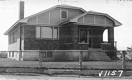
Total Photos: 1
|
| |
|
|
| Property Address: 2265 W PALMYRA DR - SPANISH FORK DISTR |
|
| Mailing Address: 348 CONCORD CT MANTECA, CA 95336 |
|
| Acreage: 5.953253 |
|
| Last Document:
60287-2015
|
|
| Subdivision Map Filing |
|
| Taxing Description:
COM N 736.23 FT & E 1507.13 FT FR W 1/4 COR. SEC. 10, T8S, R2E, SLB&M.; N 72 DEG 30' 0" W 801.11 FT; ALONG A CURVE TO R (CHORD BEARS: N 36 DEG 15' 0" W 21.29 FT, RADIUS = 18 FT); N 214.75 FT; E 2.89 FT; N 1 DEG 11' 33" W 200.77 FT; N 55 DEG 33' 40" E 31.3 FT; S 84 DEG 17' 55" E 26.42 FT; S 76 DEG 0' 0" E 175 FT; S 50 DEG 0' 0" E 90 FT; S 43 DEG 45' 2" E 750.35 FT; S 34 DEG 26' 24" W 56.27 FT TO BEG. AREA 5.953 AC.
*Taxing description NOT FOR LEGAL DOCUMENTS
|
|
- Owner Names
- Value History
- Tax History
- Location
- Photos
- Documents
- Aerial Image
| |
----- Real Estate Values ----- |
---Improvements--- |
---Greenbelt--- |
Total |
| Year |
Com |
Res |
Agr |
Tot |
Com |
Res |
Agr |
Tot |
Land |
Homesite |
Tot |
Market Value |
| 2024 |
$0 |
$175,900 |
$221,200 |
$397,100 |
$0 |
$151,000 |
$0 |
$151,000 |
$3,477 |
$112,000 |
$115,477 |
$548,100 |
| 2023 |
$0 |
$175,900 |
$221,200 |
$397,100 |
$0 |
$144,300 |
$0 |
$144,300 |
$3,192 |
$112,000 |
$115,192 |
$541,400 |
| 2022 |
$0 |
$187,500 |
$235,800 |
$423,300 |
$0 |
$139,300 |
$0 |
$139,300 |
$3,226 |
$112,000 |
$115,226 |
$562,600 |
| 2021 |
$0 |
$150,000 |
$138,700 |
$288,700 |
$0 |
$104,700 |
$0 |
$104,700 |
$3,164 |
$80,000 |
$83,164 |
$393,400 |
| 2020 |
$0 |
$125,000 |
$123,800 |
$248,800 |
$0 |
$104,700 |
$0 |
$104,700 |
$3,146 |
$28,000 |
$31,146 |
$353,500 |
| 2019 |
$0 |
$110,000 |
$84,200 |
$194,200 |
$0 |
$95,200 |
$0 |
$95,200 |
$3,158 |
$28,000 |
$31,158 |
$289,400 |
| 2018 |
$0 |
$90,000 |
$84,200 |
$174,200 |
$0 |
$86,500 |
$0 |
$86,500 |
$3,523 |
$28,000 |
$31,523 |
$260,700 |
| 2017 |
$0 |
$75,000 |
$84,200 |
$159,200 |
$0 |
$72,100 |
$0 |
$72,100 |
$3,694 |
$28,000 |
$31,694 |
$231,300 |
| 2016 |
$0 |
$55,000 |
$84,200 |
$139,200 |
$0 |
$57,700 |
$0 |
$57,700 |
$3,620 |
$28,000 |
$31,620 |
$196,900 |
| Year |
General Taxes |
Adjustments |
Net Taxes |
Fees |
Payments |
Tax Balance* |
Balance Due |
Tax District |
| 2025 |
$0.00 |
$0.00 |
$0.00 |
$0.00 |
|
$0.00
|
$0.00 |
120 - NEBO SCHOOL DIST S/A 6-7-8 |
| 2024 |
$0.00 |
$0.00 |
$0.00 |
$0.00 |
|
$0.00
|
$0.00 |
120 - NEBO SCHOOL DIST S/A 6-7-8 |
| 2023 |
$1,440.99 |
$0.00 |
$1,440.99 |
$0.00 |
|
$0.00
|
$0.00 |
120 - NEBO SCHOOL DIST S/A 6-7-8 |
| 2022 |
$1,439.73 |
$0.00 |
$1,439.73 |
$0.00 |
|
$0.00
|
$0.00 |
120 - NEBO SCHOOL DIST S/A 6-7-8 |
| 2021 |
$1,241.49 |
$0.00 |
$1,241.49 |
$0.00 |
|
$0.00
|
$0.00 |
120 - NEBO SCHOOL DIST S/A 6-7-8 |
| 2020 |
$929.33 |
$0.00 |
$929.33 |
$0.00 |
|
$0.00
|
$0.00 |
120 - NEBO SCHOOL DIST S/A 6-7-8 |
| 2019 |
$848.39 |
$0.00 |
$848.39 |
$0.00 |
|
$0.00
|
$0.00 |
120 - NEBO SCHOOL DIST S/A 6-7-8 |
| 2018 |
$831.49 |
$0.00 |
$831.49 |
$0.00 |
|
$0.00
|
$0.00 |
120 - NEBO SCHOOL DIST S/A 6-7-8 |
| 2017 |
$755.63 |
$0.00 |
$755.63 |
$0.00 |
|
$0.00
|
$0.00 |
120 - NEBO SCHOOL DIST S/A 6-7-8 |
| 2016 |
$673.32 |
$0.00 |
$673.32 |
$0.00 |
|
$0.00
|
$0.00 |
120 - NEBO SCHOOL DIST S/A 6-7-8 |
* Note: Original tax amount (Does not include applicable interest and/or fees).
| Entry # |
Date |
Recorded |
Type |
Party1 (Grantor) |
Party2 (Grantee) |
| 31766-2018 |
03/13/2018 |
04/04/2018 |
N |
UTAH COUNTY |
WHOM OF INTEREST |
| 15469-2016 |
02/11/2016 |
02/25/2016 |
FARM |
BANKS, REED J & DEE M |
WHOM OF INTEREST |
| 60287-2015 |
04/28/2015 |
07/07/2015 |
BLA |
ROACH, MARY P TEE (ET AL) |
BANKS, REED J & DEE M |
Main Menu Comments or Concerns on Value/Appraisal - Assessor's Office
Documents/Owner/Parcel information - Recorder's Office
Address Change for Tax Notice
This page was created on 7/20/2024 6:27:40 AM |