Property Information
mobile view
| Serial Number: 25:038:0031 |
Serial Life: 1981... |
|
|
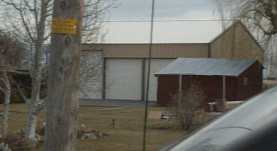
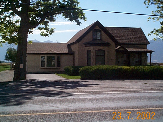 Total Photos: 2
|
| |
|
|
| Property Address: 7377 S 3200 WEST - BENJAMIN DIST |
|
| Mailing Address: 7377 S 2400 W SPANISH FORK, UT 84660 |
|
| Acreage: 1.35 |
|
| Last Document:
47490-2013
|
|
| Subdivision Map Filing |
|
| Taxing Description:
COM 1.50 CHS E & 21.25 CHS N OF SW COR OF NW 1/4, SEC 28, T8S, R2E, SLB&M; N 168.82 FT; E 3.30 CHS; S 168.82 FT; W 3.30 CHS TO BEG. ALSO COM 6.58 CHS E & 433.1 FT S OF NW COR, LOT 4, SEC 28, T8S, R2E, SLB&M; S 18..28 FT; W 1.747 CHS; N .40 CHS; W .033 CH; N 162.88 FT; E 1.78 CHS TO BEG. TOTAL AREA 1.35 ACRES.
*Taxing description NOT FOR LEGAL DOCUMENTS
|
|
- Owner Names
- Value History
- Tax History
- Location
- Photos
- Documents
- Aerial Image
| 2014... |
|
SHEPHERD, CHAD |
|
| 2014... |
|
SHEPHERD, KATIE |
|
| 2002-2013 |
|
LOSSER, JOANNE O |
|
| 2002-2013 |
|
LOSSER, NED H |
|
| 2002NV |
|
THOMAS, ELSIE S |
|
| 1997-2001 |
|
LOSSER, JOANNE O |
|
| 1997-2001 |
|
LOSSER, NED H |
|
| 1984-1996 |
|
LOSSER, JOANNE O |
|
| 1984-1996 |
|
LOSSER, NED H |
|
| 1981-1983 |
|
LOSSER, JOANNE O |
|
| 1981-1983 |
|
LOSSER, NED H |
|
| |
----- Real Estate Values ----- |
---Improvements--- |
---Greenbelt--- |
Total |
| Year |
Com |
Res |
Agr |
Tot |
Com |
Res |
Agr |
Tot |
Land |
Homesite |
Tot |
Market Value |
| 2024 |
$0 |
$175,900 |
$15,800 |
$191,700 |
$0 |
$280,500 |
$0 |
$280,500 |
$0 |
$0 |
$0 |
$472,200 |
| 2023 |
$0 |
$175,900 |
$15,800 |
$191,700 |
$0 |
$270,700 |
$0 |
$270,700 |
$0 |
$0 |
$0 |
$462,400 |
| 2022 |
$0 |
$187,500 |
$16,800 |
$204,300 |
$0 |
$188,200 |
$0 |
$188,200 |
$0 |
$0 |
$0 |
$392,500 |
| 2021 |
$0 |
$150,000 |
$9,900 |
$159,900 |
$0 |
$141,500 |
$0 |
$141,500 |
$0 |
$0 |
$0 |
$301,400 |
| 2020 |
$0 |
$125,000 |
$8,800 |
$133,800 |
$0 |
$141,500 |
$0 |
$141,500 |
$0 |
$0 |
$0 |
$275,300 |
| 2019 |
$0 |
$110,000 |
$6,000 |
$116,000 |
$0 |
$128,600 |
$0 |
$128,600 |
$0 |
$0 |
$0 |
$244,600 |
| 2018 |
$0 |
$90,000 |
$6,000 |
$96,000 |
$0 |
$124,400 |
$0 |
$124,400 |
$0 |
$0 |
$0 |
$220,400 |
| 2017 |
$0 |
$75,000 |
$6,000 |
$81,000 |
$0 |
$103,700 |
$0 |
$103,700 |
$0 |
$0 |
$0 |
$184,700 |
| 2016 |
$0 |
$55,000 |
$6,000 |
$61,000 |
$0 |
$86,800 |
$0 |
$86,800 |
$0 |
$0 |
$0 |
$147,800 |
| 2015 |
$0 |
$50,000 |
$6,000 |
$56,000 |
$0 |
$81,900 |
$0 |
$81,900 |
$0 |
$0 |
$0 |
$137,900 |
| 2014 |
$0 |
$50,000 |
$6,000 |
$56,000 |
$0 |
$81,900 |
$0 |
$81,900 |
$0 |
$0 |
$0 |
$137,900 |
| 2013 |
$0 |
$48,700 |
$17,100 |
$65,800 |
$0 |
$74,661 |
$0 |
$74,661 |
$0 |
$0 |
$0 |
$140,461 |
| 2012 |
$0 |
$48,700 |
$17,100 |
$65,800 |
$0 |
$74,661 |
$0 |
$74,661 |
$0 |
$0 |
$0 |
$140,461 |
| 2011 |
$0 |
$48,700 |
$17,100 |
$65,800 |
$0 |
$74,661 |
$0 |
$74,661 |
$0 |
$0 |
$0 |
$140,461 |
| 2010 |
$0 |
$48,700 |
$17,100 |
$65,800 |
$0 |
$74,661 |
$0 |
$74,661 |
$0 |
$0 |
$0 |
$140,461 |
| 2009 |
$0 |
$48,700 |
$17,100 |
$65,800 |
$0 |
$76,800 |
$0 |
$76,800 |
$0 |
$0 |
$0 |
$142,600 |
| 2008 |
$0 |
$48,700 |
$17,100 |
$65,800 |
$0 |
$76,800 |
$0 |
$76,800 |
$0 |
$0 |
$0 |
$142,600 |
| 2007 |
$0 |
$48,700 |
$17,100 |
$65,800 |
$0 |
$76,800 |
$0 |
$76,800 |
$0 |
$0 |
$0 |
$142,600 |
| 2006 |
$0 |
$42,373 |
$14,830 |
$57,203 |
$0 |
$69,821 |
$0 |
$69,821 |
$0 |
$0 |
$0 |
$127,024 |
| 2005 |
$0 |
$42,373 |
$14,830 |
$57,203 |
$0 |
$69,821 |
$0 |
$69,821 |
$0 |
$0 |
$0 |
$127,024 |
| 2004 |
$0 |
$42,373 |
$14,830 |
$57,203 |
$0 |
$69,821 |
$0 |
$69,821 |
$0 |
$0 |
$0 |
$127,024 |
| 2003 |
$0 |
$42,373 |
$14,830 |
$57,203 |
$0 |
$69,821 |
$0 |
$69,821 |
$0 |
$0 |
$0 |
$127,024 |
| 2002 |
$0 |
$42,373 |
$14,830 |
$57,203 |
$0 |
$69,821 |
$0 |
$69,821 |
$0 |
$0 |
$0 |
$127,024 |
| 2001 |
$0 |
$42,373 |
$14,830 |
$57,203 |
$0 |
$69,821 |
$0 |
$69,821 |
$0 |
$0 |
$0 |
$127,024 |
| 2000 |
$0 |
$39,601 |
$13,860 |
$53,461 |
$0 |
$60,735 |
$0 |
$60,735 |
$0 |
$0 |
$0 |
$114,196 |
| 1999 |
$0 |
$45,541 |
$7,920 |
$53,461 |
$0 |
$60,735 |
$0 |
$60,735 |
$0 |
$0 |
$0 |
$114,196 |
| 1998 |
$0 |
$45,541 |
$7,920 |
$53,461 |
$0 |
$60,735 |
$0 |
$60,735 |
$0 |
$0 |
$0 |
$114,196 |
| 1997 |
$0 |
$42,679 |
$10,782 |
$53,461 |
$0 |
$60,735 |
$0 |
$60,735 |
$0 |
$0 |
$0 |
$114,196 |
| 1996 |
$0 |
$30,965 |
$10,782 |
$41,747 |
$0 |
$44,065 |
$0 |
$44,065 |
$0 |
$0 |
$0 |
$85,812 |
| 1995 |
$0 |
$28,150 |
$9,802 |
$37,952 |
$0 |
$44,065 |
$0 |
$44,065 |
$0 |
$0 |
$0 |
$82,017 |
| 1994 |
$0 |
$16,462 |
$5,732 |
$22,194 |
$0 |
$35,536 |
$0 |
$35,536 |
$0 |
$0 |
$0 |
$57,730 |
| 1993 |
$0 |
$16,462 |
$5,732 |
$22,194 |
$0 |
$35,536 |
$0 |
$35,536 |
$0 |
$0 |
$0 |
$57,730 |
| 1992 |
$0 |
$15,103 |
$5,259 |
$20,362 |
$0 |
$32,602 |
$0 |
$32,602 |
$0 |
$0 |
$0 |
$52,964 |
| 1991 |
$0 |
$13,248 |
$4,613 |
$17,861 |
$0 |
$28,598 |
$0 |
$28,598 |
$0 |
$0 |
$0 |
$46,459 |
| 1990 |
$0 |
$13,248 |
$4,613 |
$17,861 |
$0 |
$28,598 |
$0 |
$28,598 |
$0 |
$0 |
$0 |
$46,459 |
| 1989 |
$0 |
$13,248 |
$4,613 |
$17,861 |
$0 |
$28,598 |
$0 |
$28,598 |
$0 |
$0 |
$0 |
$46,459 |
| 1988 |
$0 |
$13,248 |
$4,614 |
$17,862 |
$0 |
$28,598 |
$0 |
$28,598 |
$0 |
$0 |
$0 |
$46,460 |
| 1987 |
$0 |
$13,658 |
$4,756 |
$18,414 |
$0 |
$29,483 |
$0 |
$29,483 |
$0 |
$0 |
$0 |
$47,897 |
| 1986 |
$0 |
$13,659 |
$4,756 |
$18,415 |
$0 |
$29,484 |
$0 |
$29,484 |
$0 |
$0 |
$0 |
$47,899 |
| 1985 |
$0 |
$13,658 |
$4,756 |
$18,414 |
$0 |
$29,483 |
$0 |
$29,483 |
$0 |
$0 |
$0 |
$47,897 |
| 1984 |
$0 |
$13,800 |
$4,806 |
$18,606 |
$0 |
$29,783 |
$0 |
$29,783 |
$0 |
$0 |
$0 |
$48,389 |
| Year |
General Taxes |
Adjustments |
Net Taxes |
Fees |
Payments |
Tax Balance* |
Balance Due |
Tax District |
| 2025 |
$0.00 |
$0.00 |
$0.00 |
$0.00 |
|
$0.00
|
$0.00 |
160 - BENJAMIN CEMETERY S/A 6-7-8 |
| 2024 |
$2,689.01 |
$0.00 |
$2,689.01 |
$0.00 |
|
$0.00
|
$0.00 |
160 - BENJAMIN CEMETERY S/A 6-7-8 |
| 2023 |
$2,632.60 |
$0.00 |
$2,632.60 |
$0.00 |
|
$0.00
|
$0.00 |
160 - BENJAMIN CEMETERY S/A 6-7-8 |
| 2022 |
$2,292.44 |
$0.00 |
$2,292.44 |
$0.00 |
|
$0.00
|
$0.00 |
160 - BENJAMIN CEMETERY S/A 6-7-8 |
| 2021 |
$2,035.21 |
$0.00 |
$2,035.21 |
$0.00 |
|
$0.00
|
$0.00 |
160 - BENJAMIN CEMETERY S/A 6-7-8 |
| 2020 |
$1,914.06 |
$0.00 |
$1,914.06 |
$0.00 |
|
$0.00
|
$0.00 |
160 - BENJAMIN CEMETERY S/A 6-7-8 |
| 2019 |
$1,658.29 |
$0.00 |
$1,658.29 |
$0.00 |
|
$0.00
|
$0.00 |
160 - BENJAMIN CEMETERY S/A 6-7-8 |
| 2018 |
$1,565.98 |
$0.00 |
$1,565.98 |
$0.00 |
|
$0.00
|
$0.00 |
160 - BENJAMIN CEMETERY S/A 6-7-8 |
| 2017 |
$1,356.96 |
$0.00 |
$1,356.96 |
$0.00 |
|
$0.00
|
$0.00 |
160 - BENJAMIN CEMETERY S/A 6-7-8 |
| 2016 |
$1,128.07 |
$0.00 |
$1,128.07 |
$0.00 |
|
$0.00
|
$0.00 |
160 - BENJAMIN CEMETERY S/A 6-7-8 |
| 2015 |
$1,063.89 |
$0.00 |
$1,063.89 |
$0.00 |
|
$0.00
|
$0.00 |
160 - BENJAMIN CEMETERY S/A 6-7-8 |
| 2014 |
$1,063.11 |
$0.00 |
$1,063.11 |
$0.00 |
|
$0.00
|
$0.00 |
160 - BENJAMIN CEMETERY S/A 6-7-8 |
| 2013 |
$1,196.00 |
$0.00 |
$1,196.00 |
$0.00 |
|
$0.00
|
$0.00 |
160 - BENJAMIN CEMETERY S/A 6-7-8 |
| 2012 |
$1,210.78 |
$0.00 |
$1,210.78 |
$0.00 |
|
$0.00
|
$0.00 |
160 - BENJAMIN CEMETERY S/A 6-7-8 |
| 2011 |
$1,188.95 |
$0.00 |
$1,188.95 |
$0.00 |
|
$0.00
|
$0.00 |
160 - BENJAMIN CEMETERY S/A 6-7-8 |
| 2010 |
$1,161.85 |
$0.00 |
$1,161.85 |
$0.00 |
|
$0.00
|
$0.00 |
160 - BENJAMIN CEMETERY S/A 6-7-8 |
| 2009 |
$1,127.72 |
$0.00 |
$1,127.72 |
$0.00 |
|
$0.00
|
$0.00 |
160 - BENJAMIN CEMETERY S/A 6-7-8 |
| 2008 |
$1,010.25 |
$0.00 |
$1,010.25 |
$0.00 |
|
$0.00
|
$0.00 |
160 - BENJAMIN CEMETERY S/A 6-7-8 |
| 2007 |
$1,000.26 |
$0.00 |
$1,000.26 |
$0.00 |
|
$0.00
|
$0.00 |
160 - BENJAMIN CEMETERY S/A 6-7-8 |
| 2006 |
$975.92 |
$0.00 |
$975.92 |
$0.00 |
|
$0.00
|
$0.00 |
160 - BENJAMIN CEMETERY S/A 6-7-8 |
| 2005 |
$1,031.57 |
$0.00 |
$1,031.57 |
$0.00 |
|
$0.00
|
$0.00 |
160 - BENJAMIN CEMETERY S/A 6-7-8 |
| 2004 |
$1,031.57 |
$0.00 |
$1,031.57 |
$0.00 |
|
$0.00
|
$0.00 |
160 - BENJAMIN CEMETERY S/A 6-7-8 |
| 2003 |
$947.91 |
$0.00 |
$947.91 |
$0.00 |
|
$0.00
|
$0.00 |
160 - BENJAMIN CEMETERY S/A 6-7-8 |
| 2002 |
$924.64 |
$0.00 |
$924.64 |
$0.00 |
|
$0.00
|
$0.00 |
160 - BENJAMIN CEMETERY S/A 6-7-8 |
| 2001 |
$939.19 |
$0.00 |
$939.19 |
$0.00 |
|
$0.00
|
$0.00 |
160 - BENJAMIN CEMETERY S/A 6-7-8 |
| 2000 |
$830.06 |
$0.00 |
$830.06 |
$0.00 |
|
$0.00
|
$0.00 |
160 - BENJAMIN CEMETERY S/A 6-7-8 |
| 1999 |
$759.23 |
$0.00 |
$759.23 |
$0.00 |
|
$0.00
|
$0.00 |
160 - BENJAMIN CEMETERY S/A 6-7-8 |
| 1998 |
$749.61 |
$0.00 |
$749.61 |
$0.00 |
|
$0.00
|
$0.00 |
160 - BENJAMIN CEMETERY S/A 6-7-8 |
| 1997 |
$831.53 |
$0.00 |
$831.53 |
$0.00 |
|
$0.00
|
$0.00 |
160 - BENJAMIN CEMETERY S/A 6-7-8 |
| 1996 |
$558.33 |
$0.00 |
$558.33 |
$0.00 |
|
$0.00
|
$0.00 |
165 - BENJAMIN CEMETERY S/A 6-9 |
| 1995 |
$530.96 |
$0.00 |
$530.96 |
$0.00 |
|
$0.00
|
$0.00 |
165 - BENJAMIN CEMETERY S/A 6-9 |
| 1994 |
$548.47 |
$0.00 |
$548.47 |
$0.00 |
|
$0.00
|
$0.00 |
165 - BENJAMIN CEMETERY S/A 6-9 |
| 1993 |
$492.26 |
$0.00 |
$492.26 |
$0.00 |
|
$0.00
|
$0.00 |
165 - BENJAMIN CEMETERY S/A 6-9 |
| 1992 |
$436.88 |
$0.00 |
$436.88 |
$0.00 |
|
$0.00
|
$0.00 |
165 - BENJAMIN CEMETERY S/A 6-9 |
| 1991 |
$400.11 |
$0.00 |
$400.11 |
$0.00 |
|
$0.00
|
$0.00 |
165 - BENJAMIN CEMETERY S/A 6-9 |
| 1990 |
$383.82 |
$0.00 |
$383.82 |
$0.00 |
|
$0.00
|
$0.00 |
165 - BENJAMIN CEMETERY S/A 6-9 |
| 1989 |
$394.56 |
$0.00 |
$394.56 |
$0.00 |
|
$0.00
|
$0.00 |
165 - BENJAMIN CEMETARY S/A 6-9 |
| 1988 |
$391.70 |
$0.00 |
$391.70 |
$0.00 |
|
$0.00
|
$0.00 |
165 - BENJAMIN CEMETARY S/A 6-9 |
| 1987 |
$394.40 |
$0.00 |
$394.40 |
$0.00 |
|
$0.00
|
$0.00 |
165 - BENJAMIN CEMETARY S/A 6-9 |
| 1986 |
$374.66 |
$0.00 |
$374.66 |
$0.00 |
|
$0.00
|
$0.00 |
165 - BENJAMIN CEMETARY S/A 6-9 |
| 1985 |
$347.55 |
$0.00 |
$347.55 |
$0.00 |
|
$0.00
|
$0.00 |
165 - BENJAMIN CEMETARY S/A 6-9 |
| 1984 |
$341.34 |
$0.00 |
$341.34 |
$0.00 |
|
$0.00
|
$0.00 |
165 - BENJAMIN CEMETARY S/A 6-9 |
* Note: Original tax amount (Does not include applicable interest and/or fees).
| Entry # |
Date |
Recorded |
Type |
Party1 (Grantor) |
Party2 (Grantee) |
| 181563-2021 |
09/21/2021 |
10/26/2021 |
REC |
UTAH COMMUNITY CREDIT UNION TEE |
SHEPHERD, CHAD & KATIE |
| 157091-2021 |
08/28/2021 |
09/09/2021 |
RSUBTEE |
MORTGAGE ELECTRONIC REGISTRATION SYSTEMS INC (ET AL) |
SHEPHERD, CHAD & KATIE |
| 141832-2021 |
08/09/2021 |
08/13/2021 |
D TR |
SHEPHERD, CHAD & KATIE |
HOME POINT FINANCIAL CORPORATION |
| 75931-2019 |
08/05/2019 |
08/09/2019 |
D TR |
SHEPHERD, CHAD & KATIE |
UTAH COMMUNITY CREDIT UNION |
| 3187-2015 |
12/04/2014 |
01/14/2015 |
QCD |
UNITED STATES OF AMERICA |
SOUTH UTAH VALLEY ELECTRIC SERVICE DISTRICT |
| 47491-2013 |
05/13/2013 |
05/15/2013 |
D TR |
SHEPHERD, CHAD & KATIE |
PACIFIC UNION FINANCIAL |
| 47490-2013 |
05/13/2013 |
05/15/2013 |
WD |
LOSSER, NED H & JOANNE O |
SHEPHERD, CHAD & KATIE |
| 74606-2011 |
10/12/2011 |
10/19/2011 |
EAS |
SPANISH FORK IRRIGATION COMPANY |
WHOM OF INTEREST |
| 50963-2009 |
05/04/2009 |
05/08/2009 |
CT |
STATE OF UTAH |
WHOM OF INTEREST |
| 42373-2009 |
04/21/2009 |
04/21/2009 |
RESOL |
BOARD OF COUNTY COMMISSIONERS UTAH COUNTY |
WHOM OF INTEREST |
| 114949-2008 |
10/20/2008 |
10/22/2008 |
CT |
STATE OF UTAH |
WHOM OF INTEREST |
| 107508-2008 |
09/30/2008 |
09/30/2008 |
RESOL |
BOARD OF COUNTY COMMISSIONERS UTAH COUNTY |
WHOM OF INTEREST |
| 16150-1990 |
|
05/23/1990 |
S ORDIN |
UTAH COUNTY COMMISSIONERS |
WHOM OF INTEREST |
| 16149-1990 |
05/14/1990 |
05/23/1990 |
S ORDIN |
UTAH COUNTY COMMISSIONERS |
WHOM OF INTEREST |
| 16144-1990 |
|
05/23/1990 |
Z MAP |
UTAH COUNTY COMMISSIONERS |
WHOM OF INTEREST |
| 16143-1990 |
|
05/23/1990 |
Z ORDIN |
UTAH COUNTY COMMISSIONERS |
WHOM OF INTEREST |
| 16142-1990 |
05/14/1990 |
05/23/1990 |
Z ORDIN |
UTAH COUNTY COMMISSIONERS |
WHOM OF INTEREST |
Main Menu Comments or Concerns on Value/Appraisal - Assessor's Office
Documents/Owner/Parcel information - Recorder's Office
Address Change for Tax Notice
This page was created on 4/2/2025 5:04:06 PM |