Property Information
mobile view
| Serial Number: 26:008:0033 |
Serial Life: 2000 |
|
|
Total Photos: 1
|
| |
|
|
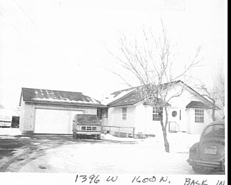
| Property Address: 1396 W 1600 NORTH - MAPLETON |
|
| Mailing Address: 1396 W 1600 N MAPLETON, UT 84664-3332 |
|
| Acreage: 0 |
|
| Last Document:
125150-1999
|
|
| Subdivision Map Filing |
|
| Taxing Description:
COM N 18.8 FT & E 660 FT FR SW COR. SEC. 3 T8S R3E SLB&M.; N 509.19 FT; E 272.5 FT; S 103.5 FT; W 121.76 FT; S 135.74 FT; W 125.74 FT; S 269.95 FT; W 25 FT TO BEG. AREA 1.272 AC.
*Taxing description NOT FOR LEGAL DOCUMENTS
|
|
- Owner Names
- Value History
- Tax History
- Location
- Photos
- Documents
- Aerial Image
| |
----- Real Estate Values ----- |
---Improvements--- |
---Greenbelt--- |
Total |
| Year |
Com |
Res |
Agr |
Tot |
Com |
Res |
Agr |
Tot |
Land |
Homesite |
Tot |
Market Value |
| 2000 |
$0 |
$45,912 |
$12,396 |
$58,308 |
$0 |
$106,847 |
$0 |
$106,847 |
$0 |
$0 |
$0 |
$165,155 |
| Year |
General Taxes |
Adjustments |
Net Taxes |
Fees |
Payments |
Tax Balance* |
Balance Due |
Tax District |
| 2000 |
$1,165.36 |
$0.00 |
$1,165.36 |
$0.00 |
|
$0.00
|
$0.00 |
140 - MAPLETON CITY |
* Note: Original tax amount (Does not include applicable interest and/or fees).
| Entry # |
Date |
Recorded |
Type |
Party1 (Grantor) |
Party2 (Grantee) |
| 21507-2000 |
02/12/2000 |
03/17/2000 |
FLA |
WEIGHT, BARRY A & BARRY ALFRED AKA (ET AL) |
RALPH H PEAY REVOCABLE TRUST AGREEMENT THE (ET AL) |
| 8868-2000 |
02/02/2000 |
02/02/2000 |
NI |
PALMER, T BRUCE |
WHOM OF INTEREST |
| 125150-1999 |
02/03/1999 |
02/03/1999 |
CORR |
JENSEN, JOHN E |
|
Main Menu Comments or Concerns on Value/Appraisal - Assessor's Office
Documents/Owner/Parcel information - Recorder's Office
Address Change for Tax Notice
This page was created on 7/22/2024 12:53:35 PM |