Property Information
mobile view
| Serial Number: 26:059:0094 |
Serial Life: 2020... |
|
|
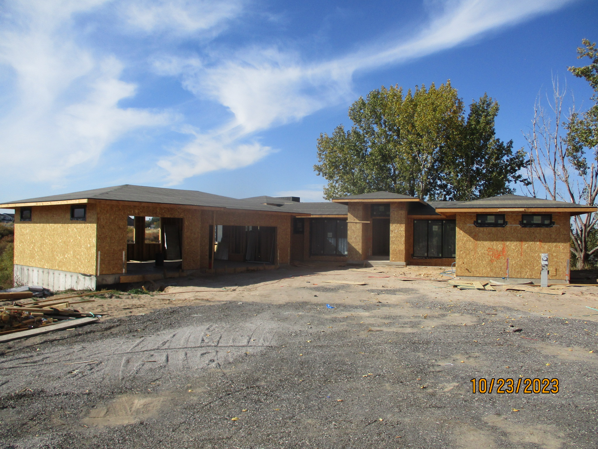 Total Photos: 1
|
| |
|
|
| Property Address: 2025 W 800 NORTH - MAPLETON |
|
| Mailing Address: 1607 E 1510 S SPANISH FORK, UT 84660-6446 |
|
| Acreage: 4.173846 |
|
| Last Document:
20373-2021
|
|
| Subdivision Map Filing |
|
| Taxing Description:
COM S 2677.2 FT & E 613.78 FT FR N 1/4 COR. SEC. 9, T8S, R3E, SLB&M.; N 88 DEG 48' 26" E 710.1 FT; N 6.51 FT; N 89 DEG 32' 55" E 4.29 FT; S 3 DEG 22' 59" E 26.15 FT; S 89 DEG 31' 0" E 129.9 FT; N 28 DEG 52' 49" E 10.19 FT; S 5 DEG 41' 0" W 421.37 FT; N 62 DEG 48' 36" W 909.35 FT; N .73 FT TO BEG. AREA 4.174 AC.
*Taxing description NOT FOR LEGAL DOCUMENTS
|
|
- Owner Names
- Value History
- Tax History
- Location
- Photos
- Documents
- Aerial Image
| |
----- Real Estate Values ----- |
---Improvements--- |
---Greenbelt--- |
Total |
| Year |
Com |
Res |
Agr |
Tot |
Com |
Res |
Agr |
Tot |
Land |
Homesite |
Tot |
Market Value |
| 2024 |
$0 |
$324,500 |
$299,600 |
$624,100 |
$0 |
$458,700 |
$58,700 |
$517,400 |
$51 |
$192,000 |
$192,051 |
$1,141,500 |
| 2023 |
$0 |
$324,500 |
$299,600 |
$624,100 |
$0 |
$245,000 |
$52,900 |
$297,900 |
$47 |
$192,000 |
$192,047 |
$922,000 |
| 2022 |
$0 |
$346,000 |
$319,400 |
$665,400 |
$0 |
$301,500 |
$52,700 |
$354,200 |
$47 |
$192,000 |
$192,047 |
$1,019,600 |
| 2021 |
$0 |
$203,500 |
$255,500 |
$459,000 |
$0 |
$231,900 |
$45,400 |
$277,300 |
$47 |
$120,000 |
$120,047 |
$736,300 |
| 2020 |
$0 |
$185,000 |
$222,200 |
$407,200 |
$0 |
$225,100 |
$45,400 |
$270,500 |
$47 |
$50,000 |
$50,047 |
$677,700 |
| Year |
General Taxes |
Adjustments |
Net Taxes |
Fees |
Payments |
Tax Balance* |
Balance Due |
Tax District |
| 2025 |
$0.00 |
$0.00 |
$0.00 |
$0.00 |
|
$0.00
|
$0.00 |
140 - MAPLETON CITY |
| 2024 |
$0.00 |
$0.00 |
$0.00 |
$0.00 |
|
$0.00
|
$0.00 |
140 - MAPLETON CITY |
| 2023 |
$6,753.11 |
$0.00 |
$6,753.11 |
$0.00 |
|
$0.00
|
$0.00 |
140 - MAPLETON CITY |
| 2022 |
$3,325.68 |
$0.00 |
$3,325.68 |
$0.00 |
|
$0.00
|
$0.00 |
140 - MAPLETON CITY |
| 2021 |
$2,903.51 |
$0.00 |
$2,903.51 |
$0.00 |
|
$0.00
|
$0.00 |
140 - MAPLETON CITY |
| 2020 |
$2,471.21 |
$0.00 |
$2,471.21 |
$0.00 |
|
$0.00
|
$0.00 |
140 - MAPLETON CITY |
* Note: Original tax amount (Does not include applicable interest and/or fees).
| Entry # |
Date |
Recorded |
Type |
Party1 (Grantor) |
Party2 (Grantee) |
| 11595-2024 |
02/19/2024 |
02/26/2024 |
EAS |
WILSON, BROCK & CHANTELL |
MAPLETON CITY |
| 48195-2023 |
07/25/2023 |
07/26/2023 |
D TR |
WILSON, BROCK & CHANTELL |
CENTRAL BANK |
| 17168-2023 |
03/21/2023 |
03/21/2023 |
R FARM |
UTAH COUNTY TREASURER |
DAYBELL, GRANT (ET AL) |
| 1718-2023 |
01/10/2023 |
01/10/2023 |
W FARM |
UTAH COUNTY ASSESSOR |
WHOM OF INTEREST |
| 104559-2022 |
09/27/2022 |
09/27/2022 |
WD |
LANDTEK LLC BY (ET AL) |
WILSON, BROCK & CHANTELL |
| 201427-2021 |
11/29/2021 |
12/03/2021 |
AGR |
MAPLETON CITY CORPORATION |
SUNRISE NORTH LLC |
| 23175-2021 |
02/05/2021 |
02/05/2021 |
REC |
PRO-TITLE AND ESCROW INC TEE |
LANDTEK LLC |
| 20374-2021 |
02/02/2021 |
02/02/2021 |
TR D |
LANDTEK LLC |
BINGHAM FAMILY ALASKA LLC |
| 20373-2021 |
02/01/2021 |
02/02/2021 |
WD |
SUNRISE NORTH LLC (ET AL) |
LANDTEK LLC N |
| 205450-2020 |
02/18/2020 |
12/22/2020 |
DECLCOV |
SUNRISE RANCH MAPLETON LLC (ET AL) |
WHOM OF INTEREST |
| 17334-2020 |
01/23/2020 |
02/11/2020 |
FARM |
SUNRISE NORTH LLC (ET AL) |
WHOM OF INTEREST |
| 124293-2019 |
11/18/2019 |
11/25/2019 |
C WD |
SUNRISE NORTH LLC (ET AL) |
SUNRISE RANCH MAPLETON LLC |
Main Menu Comments or Concerns on Value/Appraisal - Assessor's Office
Documents/Owner/Parcel information - Recorder's Office
Address Change for Tax Notice
This page was created on 8/22/2024 5:38:57 PM |