Property Information
mobile view
| Serial Number: 26:064:0270 |
Serial Life: 1999-2013 |
|
|

Total Photos: 3
|
| |
|
|
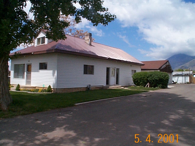
| Property Address: 685 E MAPLE ST - MAPLETON |
|
| Mailing Address: 685 E MAPLE ST MAPLETON, UT 84664-4610 |
|
| Acreage: 1.171284 |
|
| Last Document:
137804-1998
|
|
| Subdivision Map Filing |
|
| Taxing Description:
COM E 2211 FT FR SW COR. SEC. 11 T8S R3E SLB&M.; N 280.5 FT; E 265.76 FT; S 0 DEG 39' 45" W 68.76 FT; S 89 DEG 3' 10" W 19.82 FT; S 0 DEG 18' 3" E 13.41 FT; W 96.71 FT; S 198 FT; W 148.5 FT TO BEG. AREA 1.171 AC.
*Taxing description NOT FOR LEGAL DOCUMENTS
|
|
- Owner Names
- Value History
- Tax History
- Location
- Photos
- Documents
- Aerial Image
| |
----- Real Estate Values ----- |
---Improvements--- |
---Greenbelt--- |
Total |
| Year |
Com |
Res |
Agr |
Tot |
Com |
Res |
Agr |
Tot |
Land |
Homesite |
Tot |
Market Value |
| 2013 |
$0 |
$105,000 |
$6,000 |
$111,000 |
$0 |
$55,900 |
$0 |
$55,900 |
$0 |
$0 |
$0 |
$166,900 |
| 2012 |
$0 |
$113,000 |
$6,000 |
$119,000 |
$0 |
$49,900 |
$0 |
$49,900 |
$0 |
$0 |
$0 |
$168,900 |
| 2011 |
$0 |
$98,000 |
$6,000 |
$104,000 |
$0 |
$66,500 |
$0 |
$66,500 |
$0 |
$0 |
$0 |
$170,500 |
| 2010 |
$0 |
$104,377 |
$2,822 |
$107,199 |
$0 |
$70,451 |
$0 |
$70,451 |
$0 |
$0 |
$0 |
$177,650 |
| 2009 |
$0 |
$102,900 |
$4,300 |
$107,200 |
$0 |
$83,800 |
$0 |
$83,800 |
$0 |
$0 |
$0 |
$191,000 |
| 2008 |
$0 |
$102,900 |
$4,300 |
$107,200 |
$0 |
$83,800 |
$0 |
$83,800 |
$0 |
$0 |
$0 |
$191,000 |
| 2007 |
$0 |
$102,900 |
$4,300 |
$107,200 |
$0 |
$83,800 |
$0 |
$83,800 |
$0 |
$0 |
$0 |
$191,000 |
| 2006 |
$0 |
$98,000 |
$4,100 |
$102,100 |
$0 |
$83,800 |
$0 |
$83,800 |
$0 |
$0 |
$0 |
$185,900 |
| 2005 |
$0 |
$58,850 |
$10,005 |
$68,855 |
$0 |
$51,190 |
$0 |
$51,190 |
$0 |
$0 |
$0 |
$120,045 |
| 2004 |
$0 |
$58,850 |
$10,005 |
$68,855 |
$0 |
$51,190 |
$0 |
$51,190 |
$0 |
$0 |
$0 |
$120,045 |
| 2003 |
$0 |
$58,850 |
$10,005 |
$68,855 |
$0 |
$51,190 |
$0 |
$51,190 |
$0 |
$0 |
$0 |
$120,045 |
| 2002 |
$0 |
$58,850 |
$10,005 |
$68,855 |
$0 |
$51,190 |
$0 |
$51,190 |
$0 |
$0 |
$0 |
$120,045 |
| 2001 |
$0 |
$58,850 |
$10,005 |
$68,855 |
$0 |
$51,190 |
$0 |
$51,190 |
$0 |
$0 |
$0 |
$120,045 |
| 2000 |
$0 |
$55,000 |
$9,350 |
$64,350 |
$0 |
$44,544 |
$0 |
$44,544 |
$0 |
$0 |
$0 |
$108,894 |
| 1999 |
$0 |
$55,000 |
$9,350 |
$64,350 |
$0 |
$44,544 |
$0 |
$44,544 |
$0 |
$0 |
$0 |
$108,894 |
| Year |
General Taxes |
Adjustments |
Net Taxes |
Fees |
Payments |
Tax Balance* |
Balance Due |
Tax District |
| 2013 |
$1,388.79 |
$0.00 |
$1,388.79 |
$0.00 |
|
$0.00
|
$0.00 |
140 - MAPLETON CITY |
| 2012 |
$1,437.08 |
$0.00 |
$1,437.08 |
$0.00 |
|
$0.00
|
$0.00 |
140 - MAPLETON CITY |
| 2011 |
$1,419.92 |
$0.00 |
$1,419.92 |
$0.00 |
|
$0.00
|
$0.00 |
140 - MAPLETON CITY |
| 2010 |
$1,415.77 |
$0.00 |
$1,415.77 |
$0.00 |
|
$0.00
|
$0.00 |
140 - MAPLETON CITY |
| 2009 |
$1,432.42 |
$0.00 |
$1,432.42 |
$0.00 |
|
$0.00
|
$0.00 |
140 - MAPLETON CITY |
| 2008 |
$1,304.79 |
$0.00 |
$1,304.79 |
$0.00 |
|
$0.00
|
$0.00 |
140 - MAPLETON CITY |
| 2007 |
$1,220.91 |
$0.00 |
$1,220.91 |
$0.00 |
|
$0.00
|
$0.00 |
140 - MAPLETON CITY |
| 2006 |
$1,285.10 |
$0.00 |
$1,285.10 |
$0.00 |
|
$0.00
|
$0.00 |
140 - MAPLETON CITY |
| 2005 |
$957.84 |
$0.00 |
$957.84 |
$0.00 |
|
$0.00
|
$0.00 |
140 - MAPLETON CITY |
| 2004 |
$959.11 |
$0.00 |
$959.11 |
$0.00 |
|
$0.00
|
$0.00 |
140 - MAPLETON CITY |
| 2003 |
$879.41 |
$0.00 |
$879.41 |
$0.00 |
|
$0.00
|
$0.00 |
140 - MAPLETON CITY |
| 2002 |
$854.66 |
$0.00 |
$854.66 |
$0.00 |
|
$0.00
|
$0.00 |
140 - MAPLETON CITY |
| 2001 |
$861.64 |
$0.00 |
$861.64 |
$0.00 |
|
$0.00
|
$0.00 |
140 - MAPLETON CITY |
| 2000 |
$774.76 |
$0.00 |
$774.76 |
$0.00 |
|
$0.00
|
$0.00 |
140 - MAPLETON CITY |
| 1999 |
$736.05 |
$0.00 |
$736.05 |
$0.00 |
|
$0.00
|
$0.00 |
140 - MAPLETON CITY |
* Note: Original tax amount (Does not include applicable interest and/or fees).
| Entry # |
Date |
Recorded |
Type |
Party1 (Grantor) |
Party2 (Grantee) |
| 86838-2013 |
09/10/2013 |
09/11/2013 |
BLA |
JACKSON, JOHN N & JULIA B TEE (ET AL) |
CANTO, RON (ET AL) |
| 101895-2007 |
07/11/2007 |
07/13/2007 |
QCD |
JACKSON, JOHN N & JULIA B |
JACKSON, JOHN N & JULIA B TEE |
| 62638-2004 |
05/28/2004 |
06/02/2004 |
REC |
CENTRAL BANK TEE |
JACKSON, JOHN N & JULIA B |
| 137804-1998 |
|
12/31/1998 |
QCD |
JACKSON, JOHN N & JULIA B |
JACKSON, JOHN N & JULIA B |
Main Menu Comments or Concerns on Value/Appraisal - Assessor's Office
Documents/Owner/Parcel information - Recorder's Office
Address Change for Tax Notice
This page was created on 7/22/2024 11:21:21 PM |