Property Information
mobile view
| Serial Number: 26:064:0313 |
Serial Life: 2011... |
|
|
Total Photos: 1
|
| |
|
|
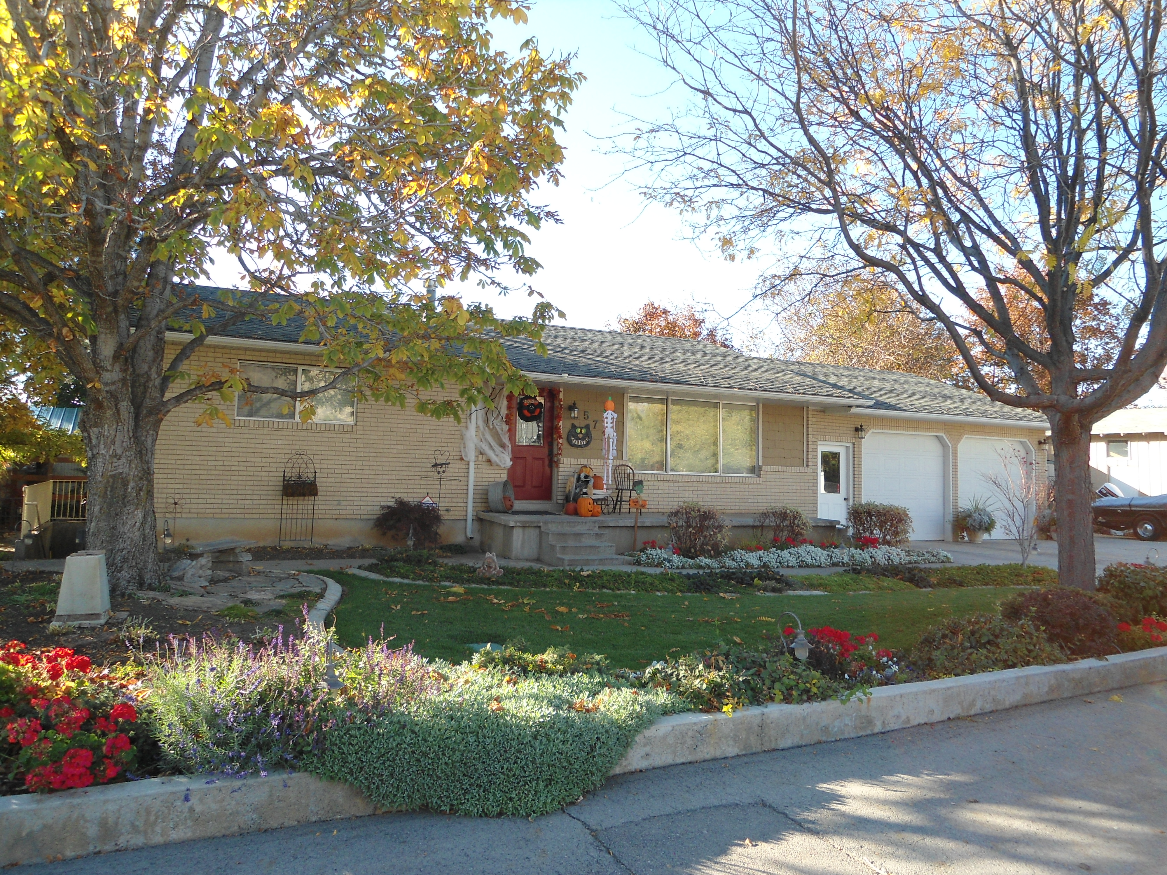
| Property Address: 571 N 400 EAST - MAPLETON |
|
| Mailing Address: 571 N 400 E MAPLETON, UT 84664-3651 |
|
| Acreage: 0.29133 |
|
| Last Document:
46728-2010
|
|
| Subdivision Map Filing |
|
| Taxing Description:
COM S 0 DEG 1' 55" W 796.58 FT & E 1173.44 FT FR W 1/4 COR. SEC. 11, T8S, R3E, SLB&M.; N 0 DEG 4' 24" E 109.48 FT; S 89 DEG 31' 59" E 117.67 FT; S 0 DEG 44' 0" W 107.49 FT; S 89 DEG 29' 8" W 116.43 FT TO BEG. AREA 0.291 AC.
*Taxing description NOT FOR LEGAL DOCUMENTS
|
|
- Owner Names
- Value History
- Tax History
- Location
- Photos
- Documents
- Aerial Image
| |
----- Real Estate Values ----- |
---Improvements--- |
---Greenbelt--- |
Total |
| Year |
Com |
Res |
Agr |
Tot |
Com |
Res |
Agr |
Tot |
Land |
Homesite |
Tot |
Market Value |
| 2024 |
$0 |
$232,000 |
$0 |
$232,000 |
$0 |
$293,800 |
$0 |
$293,800 |
$0 |
$0 |
$0 |
$525,800 |
| 2023 |
$0 |
$232,000 |
$0 |
$232,000 |
$0 |
$292,400 |
$0 |
$292,400 |
$0 |
$0 |
$0 |
$524,400 |
| 2022 |
$0 |
$247,400 |
$0 |
$247,400 |
$0 |
$320,200 |
$0 |
$320,200 |
$0 |
$0 |
$0 |
$567,600 |
| 2021 |
$0 |
$154,600 |
$0 |
$154,600 |
$0 |
$246,300 |
$0 |
$246,300 |
$0 |
$0 |
$0 |
$400,900 |
| 2020 |
$0 |
$136,800 |
$0 |
$136,800 |
$0 |
$246,300 |
$0 |
$246,300 |
$0 |
$0 |
$0 |
$383,100 |
| 2019 |
$0 |
$131,200 |
$0 |
$131,200 |
$0 |
$214,200 |
$0 |
$214,200 |
$0 |
$0 |
$0 |
$345,400 |
| 2018 |
$0 |
$110,500 |
$0 |
$110,500 |
$0 |
$178,500 |
$0 |
$178,500 |
$0 |
$0 |
$0 |
$289,000 |
| 2017 |
$0 |
$103,600 |
$0 |
$103,600 |
$0 |
$161,800 |
$0 |
$161,800 |
$0 |
$0 |
$0 |
$265,400 |
| 2016 |
$0 |
$96,700 |
$0 |
$96,700 |
$0 |
$138,200 |
$0 |
$138,200 |
$0 |
$0 |
$0 |
$234,900 |
| 2015 |
$0 |
$86,300 |
$0 |
$86,300 |
$0 |
$136,500 |
$0 |
$136,500 |
$0 |
$0 |
$0 |
$222,800 |
| 2014 |
$0 |
$82,900 |
$0 |
$82,900 |
$0 |
$124,000 |
$0 |
$124,000 |
$0 |
$0 |
$0 |
$206,900 |
| 2013 |
$0 |
$66,400 |
$0 |
$66,400 |
$0 |
$117,700 |
$0 |
$117,700 |
$0 |
$0 |
$0 |
$184,100 |
| 2012 |
$0 |
$71,400 |
$0 |
$71,400 |
$0 |
$101,500 |
$0 |
$101,500 |
$0 |
$0 |
$0 |
$172,900 |
| 2011 |
$0 |
$61,900 |
$0 |
$61,900 |
$0 |
$121,100 |
$0 |
$121,100 |
$0 |
$0 |
$0 |
$183,000 |
| Year |
General Taxes |
Adjustments |
Net Taxes |
Fees |
Payments |
Tax Balance* |
Balance Due |
Tax District |
| 2025 |
$0.00 |
$0.00 |
$0.00 |
$0.00 |
|
$0.00
|
$0.00 |
140 - MAPLETON CITY |
| 2024 |
$0.00 |
$0.00 |
$0.00 |
$0.00 |
|
$0.00
|
$0.00 |
140 - MAPLETON CITY |
| 2023 |
$2,925.73 |
$0.00 |
$2,925.73 |
$0.00 |
|
$0.00
|
$0.00 |
140 - MAPLETON CITY |
| 2022 |
$3,202.65 |
$0.00 |
$3,202.65 |
$0.00 |
|
$0.00
|
$0.00 |
140 - MAPLETON CITY |
| 2021 |
$2,678.79 |
$0.00 |
$2,678.79 |
$0.00 |
|
$0.00
|
$0.00 |
140 - MAPLETON CITY |
| 2020 |
$2,646.45 |
$0.00 |
$2,646.45 |
$0.00 |
|
$0.00
|
$0.00 |
140 - MAPLETON CITY |
| 2019 |
$2,337.58 |
$0.00 |
$2,337.58 |
$0.00 |
|
$0.00
|
$0.00 |
140 - MAPLETON CITY |
| 2018 |
$2,054.59 |
$0.00 |
$2,054.59 |
$0.00 |
|
$0.00
|
$0.00 |
140 - MAPLETON CITY |
| 2017 |
$1,955.41 |
$0.00 |
$1,955.41 |
$0.00 |
|
$0.00
|
$0.00 |
140 - MAPLETON CITY |
| 2016 |
$1,741.03 |
$0.00 |
$1,741.03 |
$0.00 |
|
$0.00
|
$0.00 |
140 - MAPLETON CITY |
| 2015 |
$1,661.40 |
$0.00 |
$1,661.40 |
$0.00 |
|
$0.00
|
$0.00 |
140 - MAPLETON CITY |
| 2014 |
$1,571.05 |
$0.00 |
$1,571.05 |
$0.00 |
|
$0.00
|
$0.00 |
140 - MAPLETON CITY |
| 2013 |
$1,488.14 |
$0.00 |
$1,488.14 |
$0.00 |
|
$0.00
|
$0.00 |
140 - MAPLETON CITY |
| 2012 |
$1,429.56 |
$0.00 |
$1,429.56 |
$0.00 |
|
$0.00
|
$0.00 |
140 - MAPLETON CITY |
| 2011 |
$1,481.37 |
$0.00 |
$1,481.37 |
$0.00 |
|
$0.00
|
$0.00 |
140 - MAPLETON CITY |
* Note: Original tax amount (Does not include applicable interest and/or fees).
| Entry # |
Date |
Recorded |
Type |
Party1 (Grantor) |
Party2 (Grantee) |
| 46728-2010 |
06/07/2010 |
06/07/2010 |
QCD |
HANSEN, ROLAND F & RHODA J (ET AL) |
SHEPPARD, ROY V & MARLENE H |
Main Menu Comments or Concerns on Value/Appraisal - Assessor's Office
Documents/Owner/Parcel information - Recorder's Office
Address Change for Tax Notice
This page was created on 7/25/2024 6:22:15 PM |