Property Information
mobile view
| Serial Number: 26:066:0021 |
Serial Life: 1981-2002 |
|
|
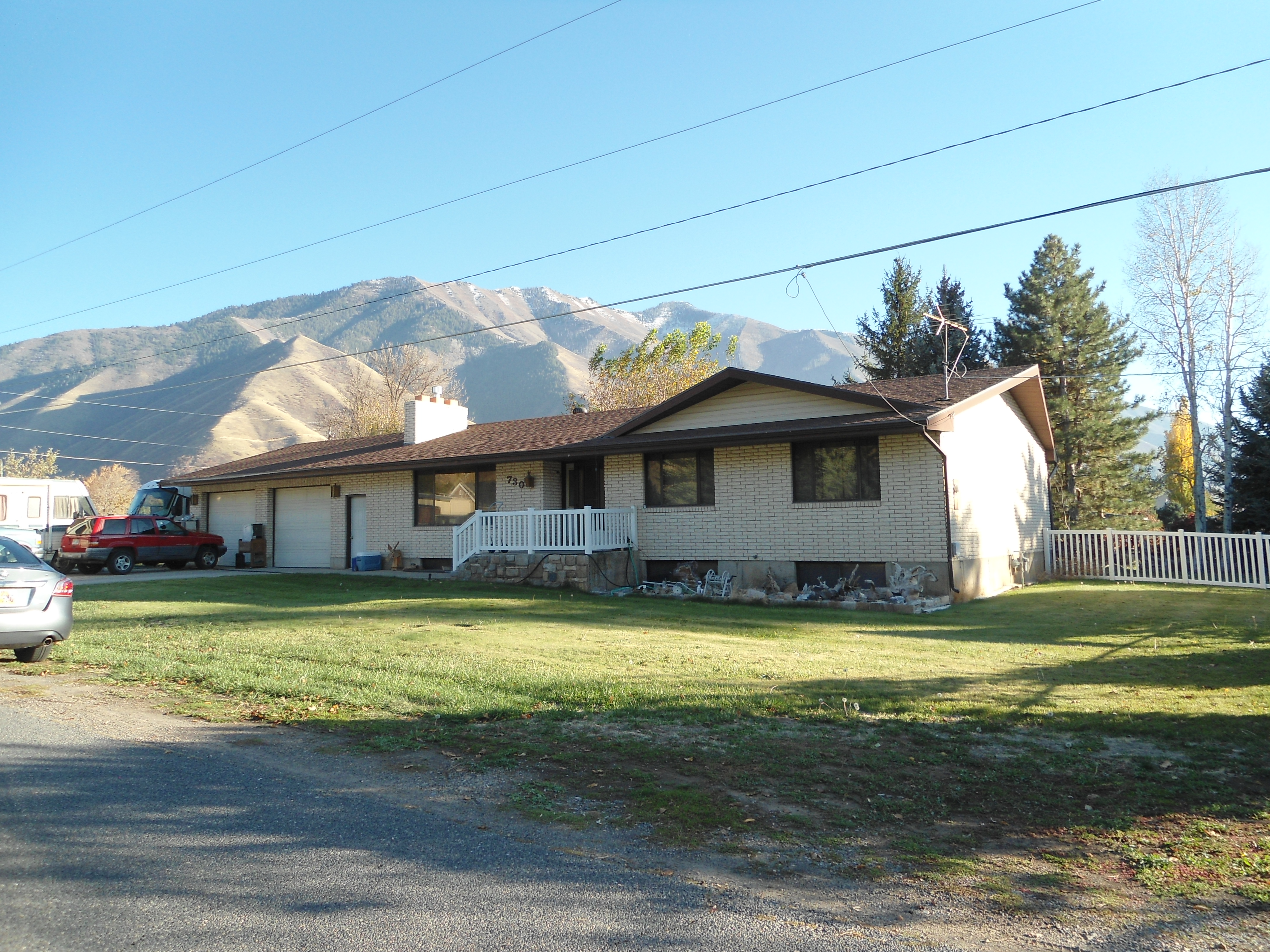 Total Photos: 1
|
| |
|
|
| Property Address: 908 E 1600 NORTH - MAPLETON |
|
| Mailing Address: 908 E 1600 N MAPLETON, UT 84664-3805 |
|
| Acreage: 2.62 |
|
| Last Document:
87934-2002
|
|
| Subdivision Map Filing |
|
| Taxing Description:
COM E 381.8 FT FR N1/4 COR SEC 11, T8S, R3E, SLM; S 16' E 46.6 !T; S 17 31' W 232.7 FT;S 7 21' W 81.1 FT; S 2 48' W 311.8 FT; S 89 40' E 122.1 FT; N 100 FT;E 99 FT; N 560 FT; W 129.60 FT TO BEG. AREA 2.62 ACRES.
*Taxing description NOT FOR LEGAL DOCUMENTS
|
|
- Owner Names
- Value History
- Tax History
- Location
- Photos
- Documents
- Aerial Image
| |
----- Real Estate Values ----- |
---Improvements--- |
---Greenbelt--- |
Total |
| Year |
Com |
Res |
Agr |
Tot |
Com |
Res |
Agr |
Tot |
Land |
Homesite |
Tot |
Market Value |
| 2002 |
$0 |
$29,615 |
$69,691 |
$99,306 |
$0 |
$122,965 |
$0 |
$122,965 |
$1,007 |
$29,615 |
$30,622 |
$222,271 |
| 2001 |
$0 |
$29,615 |
$69,691 |
$99,306 |
$0 |
$122,965 |
$0 |
$122,965 |
$948 |
$29,615 |
$30,563 |
$222,271 |
| 2000 |
$0 |
$27,678 |
$65,132 |
$92,810 |
$0 |
$110,174 |
$0 |
$110,174 |
$1,067 |
$27,678 |
$28,745 |
$202,984 |
| 1999 |
$0 |
$46,236 |
$59,101 |
$105,337 |
$0 |
$110,174 |
$0 |
$110,174 |
$948 |
$27,678 |
$28,626 |
$215,511 |
| 1998 |
$0 |
$46,236 |
$59,101 |
$105,337 |
$0 |
$110,174 |
$0 |
$110,174 |
$889 |
$27,678 |
$28,567 |
$215,511 |
| 1997 |
$0 |
$44,331 |
$61,006 |
$105,337 |
$0 |
$110,174 |
$0 |
$110,174 |
$889 |
$27,678 |
$28,567 |
$215,511 |
| 1996 |
$0 |
$37,838 |
$61,006 |
$98,844 |
$0 |
$94,037 |
$0 |
$94,037 |
$1,067 |
$27,678 |
$28,745 |
$192,881 |
| 1995 |
$0 |
$34,398 |
$55,460 |
$89,858 |
$0 |
$94,037 |
$0 |
$94,037 |
$770 |
$25,162 |
$25,932 |
$183,895 |
| 1994 |
$0 |
$20,116 |
$32,433 |
$52,549 |
$0 |
$75,836 |
$0 |
$75,836 |
$852 |
$14,715 |
$15,567 |
$128,385 |
| 1993 |
$0 |
$20,116 |
$32,433 |
$52,549 |
$0 |
$75,836 |
$0 |
$75,836 |
$852 |
$14,715 |
$15,567 |
$128,385 |
| 1992 |
$0 |
$18,455 |
$29,755 |
$48,210 |
$0 |
$69,574 |
$0 |
$69,574 |
$852 |
$13,500 |
$14,352 |
$117,784 |
| 1991 |
$0 |
$18,455 |
$29,755 |
$48,210 |
$0 |
$61,030 |
$0 |
$61,030 |
$852 |
$13,500 |
$14,352 |
$109,240 |
| 1990 |
$0 |
$18,455 |
$29,755 |
$48,210 |
$0 |
$61,030 |
$0 |
$61,030 |
$852 |
$13,500 |
$14,352 |
$109,240 |
| 1989 |
$0 |
$18,455 |
$29,755 |
$48,210 |
$0 |
$61,030 |
$0 |
$61,030 |
$850 |
$13,175 |
$14,025 |
$109,240 |
| 1988 |
$0 |
$18,455 |
$29,755 |
$48,210 |
$0 |
$61,030 |
$0 |
$61,030 |
$850 |
$13,175 |
$14,025 |
$109,240 |
| 1987 |
$0 |
$19,025 |
$30,675 |
$49,700 |
$0 |
$62,917 |
$0 |
$62,917 |
$850 |
$13,583 |
$14,433 |
$112,617 |
| 1986 |
$0 |
$19,025 |
$30,675 |
$49,700 |
$0 |
$62,918 |
$0 |
$62,918 |
$850 |
$13,584 |
$14,434 |
$112,618 |
| 1985 |
$0 |
$19,025 |
$30,675 |
$49,700 |
$0 |
$62,916 |
$0 |
$62,916 |
$170 |
$13,583 |
$13,753 |
$112,616 |
| 1984 |
$0 |
$19,217 |
$30,988 |
$50,205 |
$0 |
$63,550 |
$0 |
$63,550 |
$170 |
$13,717 |
$13,887 |
$113,755 |
| Year |
General Taxes |
Adjustments |
Net Taxes |
Fees |
Payments |
Tax Balance* |
Balance Due |
Tax District |
| 2002 |
$1,029.13 |
$0.00 |
$1,029.13 |
$0.00 |
|
$0.00
|
$0.00 |
140 - MAPLETON CITY |
| 2001 |
$1,036.82 |
$0.00 |
$1,036.82 |
$0.00 |
|
$0.00
|
$0.00 |
140 - MAPLETON CITY |
| 2000 |
$929.32 |
$0.00 |
$929.32 |
$0.00 |
|
$0.00
|
$0.00 |
140 - MAPLETON CITY |
| 1999 |
$881.52 |
$0.00 |
$881.52 |
$0.00 |
|
$0.00
|
$0.00 |
140 - MAPLETON CITY |
| 1998 |
$865.19 |
$0.00 |
$865.19 |
$0.00 |
|
$0.00
|
$0.00 |
140 - MAPLETON CITY |
| 1997 |
$859.36 |
$0.00 |
$859.36 |
$0.00 |
|
$0.00
|
$0.00 |
140 - MAPLETON CITY |
| 1996 |
$743.01 |
$0.00 |
$743.01 |
$0.00 |
|
$0.00
|
$0.00 |
140 - MAPLETON CITY |
| 1995 |
$724.71 |
$0.00 |
$724.71 |
$0.00 |
|
$0.00
|
$0.00 |
140 - MAPLETON CITY |
| 1994 |
$854.61 |
$0.00 |
$854.61 |
$0.00 |
|
$0.00
|
$0.00 |
140 - MAPLETON CITY |
| 1993 |
$775.61 |
$0.00 |
$775.61 |
$0.00 |
|
$0.00
|
$0.00 |
140 - MAPLETON CITY |
| 1992 |
$698.27 |
$0.00 |
$698.27 |
$0.00 |
|
$0.00
|
$0.00 |
140 - MAPLETON CITY |
| 1991 |
$676.52 |
$0.00 |
$676.52 |
$0.00 |
|
$0.00
|
$0.00 |
140 - MAPLETON CITY |
| 1990 |
$669.42 |
$0.00 |
$669.42 |
$0.00 |
|
$0.00
|
$0.00 |
140 - MAPLETON CITY |
| 1989 |
$686.31 |
$0.00 |
$686.31 |
$0.00 |
|
$0.00
|
$0.00 |
140 - MAPLETON CITY |
| 1988 |
$692.30 |
$0.00 |
$692.30 |
$0.00 |
|
$0.00
|
$0.00 |
140 - MAPLETON CITY |
| 1987 |
$712.47 |
$0.00 |
$712.47 |
$0.00 |
|
$0.00
|
$0.00 |
140 - MAPLETON CITY |
| 1986 |
$674.70 |
$0.00 |
$674.70 |
$0.00 |
|
$0.00
|
$0.00 |
140 - MAPLETON CITY |
| 1985 |
$679.16 |
$0.00 |
$679.16 |
$0.00 |
|
$0.00
|
$0.00 |
140 - MAPLETON CITY |
| 1984 |
$650.68 |
$0.00 |
$650.68 |
$0.00 |
|
$0.00
|
$0.00 |
140 - MAPLETON CITY |
* Note: Original tax amount (Does not include applicable interest and/or fees).
| Entry # |
Date |
Recorded |
Type |
Party1 (Grantor) |
Party2 (Grantee) |
| 87934-2002 |
07/26/2002 |
08/01/2002 |
BLA |
HILLOCK, JOSEPH H & MARY M TEE (ET AL) |
NOYES, RONNEY L & MARY P (ET AL) |
| 87933-2002 |
07/31/2002 |
08/01/2002 |
PERREPD |
EDMUNDS, ELLE MARY M & PAUL K PERREP |
EDMUNDS, ELLA MARY M |
Main Menu Comments or Concerns on Value/Appraisal - Assessor's Office
Documents/Owner/Parcel information - Recorder's Office
Address Change for Tax Notice
This page was created on 4/5/2025 1:56:05 AM |