Property Information
mobile view
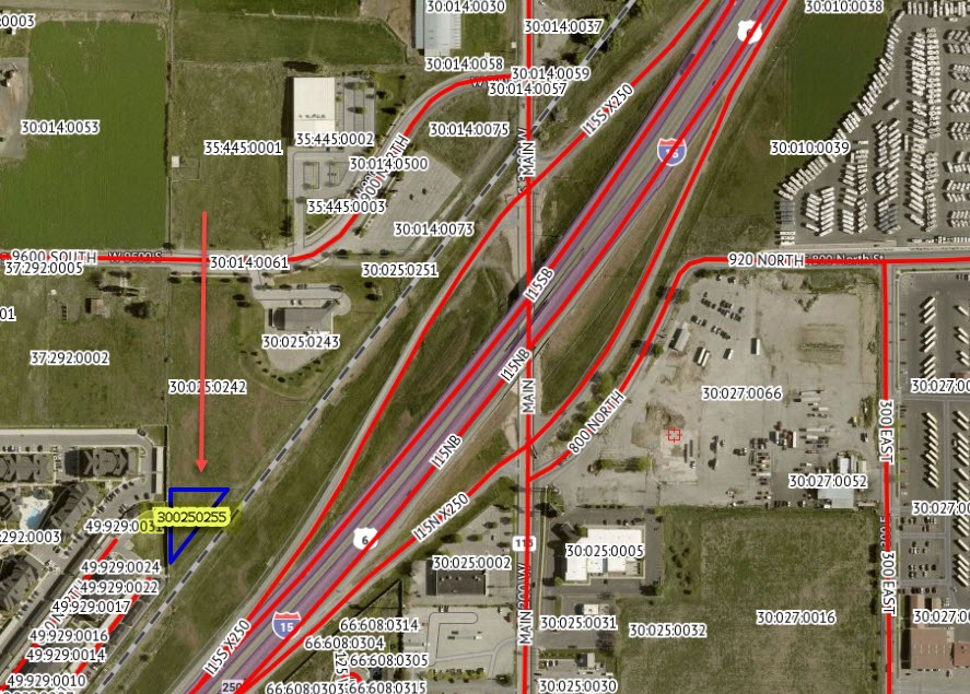
| Serial Number: 30:025:0255 |
Serial Life: 2018... |
|
|
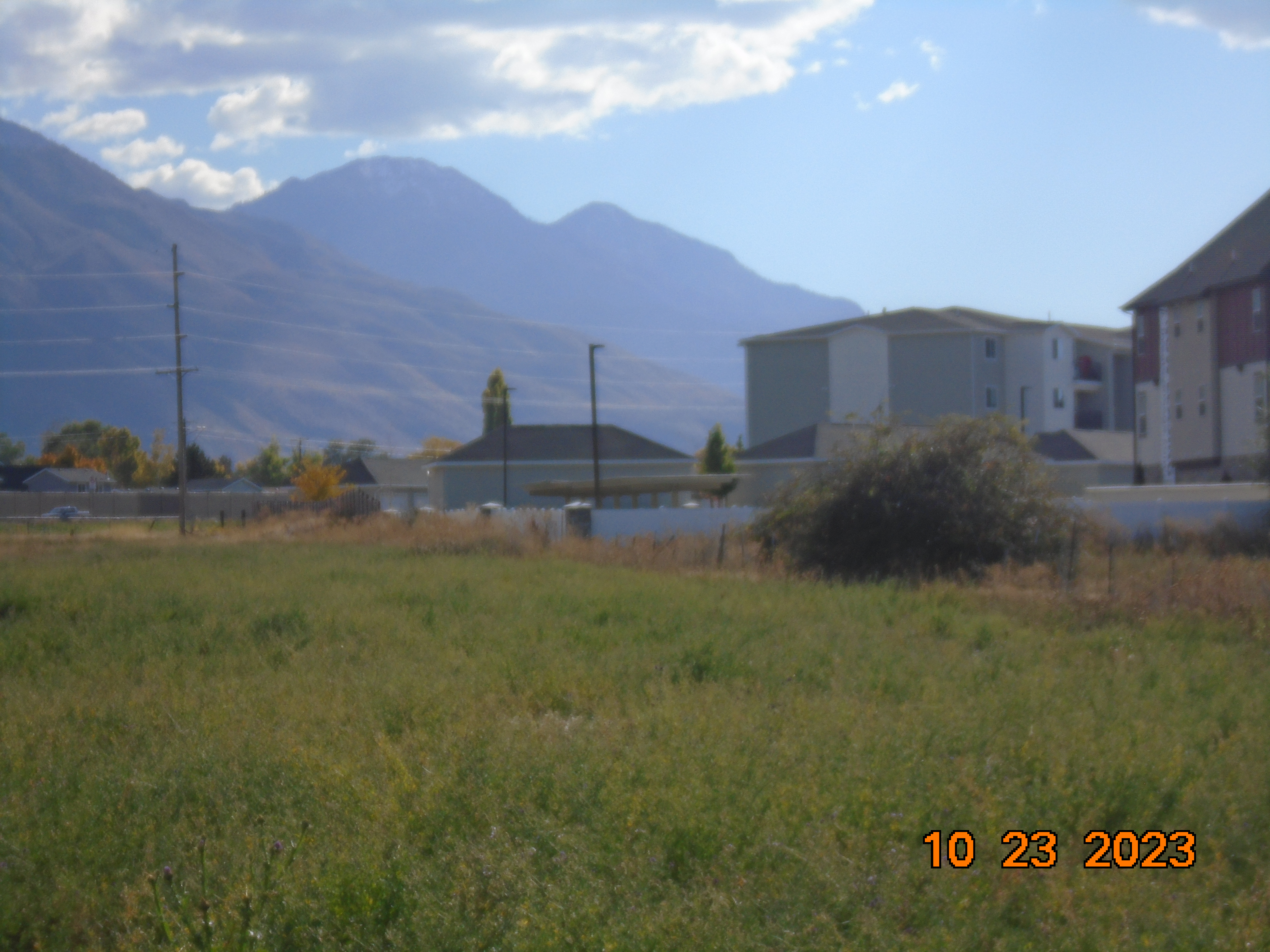 Total Photos: 5
|
| |
|
|
| Property Address: |
|
| Mailing Address: %HILL, JUSTIN 55 W LAKE VIEW DR SALEM, UT 84653 |
|
| Acreage: 0.371357 |
|
| Last Document:
13293-2017
|
|
| Subdivision Map Filing |
|
| Taxing Description:
COM S 10.09 CH & N 89 DEG 0' 0" W 23.08 CH FR NE COR. SEC. 8, T9S, R2E, SLB&M.; S 0 DEG 30' 0" W 3.05 CH; N 38 DEG 39' 0" E 3.9 CH; N 89 DEG 0' 0" W 2.35 CH TO BEG. AREA 0.371 AC.
*Taxing description NOT FOR LEGAL DOCUMENTS
|
|
- Owner Names
- Value History
- Tax History
- Location
- Photos
- Documents
- Aerial Image
| |
----- Real Estate Values ----- |
---Improvements--- |
---Greenbelt--- |
Total |
| Year |
Com |
Res |
Agr |
Tot |
Com |
Res |
Agr |
Tot |
Land |
Homesite |
Tot |
Market Value |
| 2024 |
$28,000 |
$0 |
$0 |
$28,000 |
$0 |
$0 |
$0 |
$0 |
$0 |
$0 |
$0 |
$28,000 |
| 2023 |
$22,800 |
$0 |
$0 |
$22,800 |
$0 |
$0 |
$0 |
$0 |
$0 |
$0 |
$0 |
$22,800 |
| 2022 |
$22,800 |
$0 |
$0 |
$22,800 |
$0 |
$0 |
$0 |
$0 |
$0 |
$0 |
$0 |
$22,800 |
| 2021 |
$22,800 |
$0 |
$0 |
$22,800 |
$0 |
$0 |
$0 |
$0 |
$0 |
$0 |
$0 |
$22,800 |
| 2020 |
$27,200 |
$0 |
$0 |
$27,200 |
$0 |
$0 |
$0 |
$0 |
$0 |
$0 |
$0 |
$27,200 |
| 2019 |
$26,400 |
$0 |
$0 |
$26,400 |
$0 |
$0 |
$0 |
$0 |
$0 |
$0 |
$0 |
$26,400 |
| 2018 |
$24,000 |
$0 |
$0 |
$24,000 |
$0 |
$0 |
$0 |
$0 |
$0 |
$0 |
$0 |
$24,000 |
| Year |
General Taxes |
Adjustments |
Net Taxes |
Fees |
Payments |
Tax Balance* |
Balance Due |
Tax District |
| 2025 |
$0.00 |
$0.00 |
$0.00 |
$0.00 |
|
$0.00
|
$0.00 |
170 - PAYSON CITY |
| 2024 |
$275.13 |
$0.00 |
$275.13 |
$0.00 |
|
$0.00
|
$0.00 |
170 - PAYSON CITY |
| 2023 |
$223.42 |
$0.00 |
$223.42 |
$0.00 |
|
$0.00
|
$0.00 |
170 - PAYSON CITY |
| 2022 |
$227.16 |
$0.00 |
$227.16 |
$0.00 |
|
$0.00
|
$0.00 |
170 - PAYSON CITY |
| 2021 |
$257.50 |
$0.00 |
$257.50 |
$0.00 |
|
$0.00
|
$0.00 |
170 - PAYSON CITY |
| 2020 |
$314.00 |
$0.00 |
$314.00 |
$0.00 |
|
$0.00
|
$0.00 |
170 - PAYSON CITY |
| 2019 |
$297.26 |
$0.00 |
$297.26 |
$0.00 |
|
$0.00
|
$0.00 |
170 - PAYSON CITY |
| 2018 |
$280.39 |
$0.00 |
$280.39 |
$0.00 |
|
$0.00
|
$0.00 |
170 - PAYSON CITY |
* Note: Original tax amount (Does not include applicable interest and/or fees).
| Entry # |
Date |
Recorded |
Type |
Party1 (Grantor) |
Party2 (Grantee) |
| 21741-2020 |
02/18/2020 |
02/21/2020 |
REC |
CENTRAL BANK TEE |
R & C LLC |
| 13293-2017 |
07/06/2016 |
02/08/2017 |
S PLAT |
R&C LLC |
STERLING GROVE PLAT B |
Main Menu Comments or Concerns on Value/Appraisal - Assessor's Office
Documents/Owner/Parcel information - Recorder's Office
Address Change for Tax Notice
This page was created on 4/19/2025 4:40:03 AM |