Property Information
mobile view
| Serial Number: 36:899:0021 |
Serial Life: 2012... |
|
|
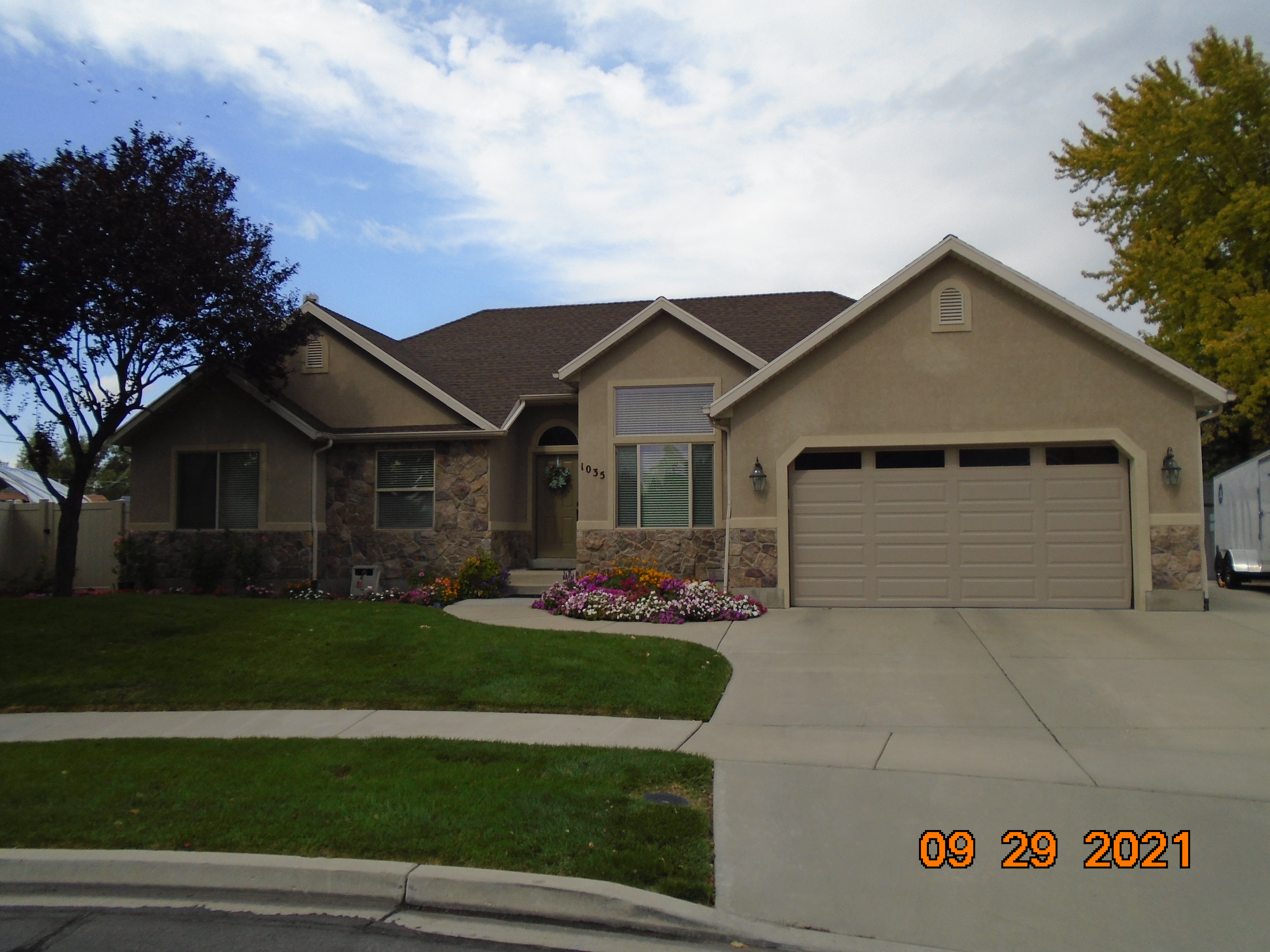 Total Photos: 1
|
| |
|
|
| Property Address: 1035 E 440 NORTH - OREM |
|
| Mailing Address: 70 KINGS PEAK LINDON, UT 84042-2223 |
|
| Acreage: 0.230887 |
|
| Last Document:
36318-2011
|
|
| Subdivision Map Filing |
|
| Taxing Description:
PART LOT 9, PLAT A, CAROLYN ESTATES SUB DESCRIBED AS FOLLOWS:; COM FR NW COR. SAID LOT 9; N 88 DEG 0' 0" E 113.49 FT; N 88 DEG 8' 0" E 8.64 FT; S 23 DEG 42' 51" E 41.68 FT ALONG A FENCE; S 13 DEG 23' 33" E 44.07 FT ALONG A FENCE; ALONG A CURVE TO L (CHORD BEARS: S 64 DEG 9' 23" W 47.6 FT, RADIUS = 40 FT); N 60 DEG 18' 36" W 121.76 FT; N 0 DEG 37' 34" W 37.23 FT TO BEG. AREA 0.231 AC.
*Taxing description NOT FOR LEGAL DOCUMENTS
|
|
- Owner Names
- Value History
- Tax History
- Location
- Photos
- Documents
- Aerial Image
| |
----- Real Estate Values ----- |
---Improvements--- |
---Greenbelt--- |
Total |
| Year |
Com |
Res |
Agr |
Tot |
Com |
Res |
Agr |
Tot |
Land |
Homesite |
Tot |
Market Value |
| 2024 |
$0 |
$245,500 |
$0 |
$245,500 |
$0 |
$310,900 |
$0 |
$310,900 |
$0 |
$0 |
$0 |
$556,400 |
| 2023 |
$0 |
$245,400 |
$0 |
$245,400 |
$0 |
$322,100 |
$0 |
$322,100 |
$0 |
$0 |
$0 |
$567,500 |
| 2022 |
$0 |
$261,600 |
$0 |
$261,600 |
$0 |
$285,600 |
$0 |
$285,600 |
$0 |
$0 |
$0 |
$547,200 |
| 2021 |
$0 |
$153,900 |
$0 |
$153,900 |
$0 |
$236,000 |
$0 |
$236,000 |
$0 |
$0 |
$0 |
$389,900 |
| 2020 |
$0 |
$123,100 |
$0 |
$123,100 |
$0 |
$231,400 |
$0 |
$231,400 |
$0 |
$0 |
$0 |
$354,500 |
| 2019 |
$0 |
$112,300 |
$0 |
$112,300 |
$0 |
$231,400 |
$0 |
$231,400 |
$0 |
$0 |
$0 |
$343,700 |
| 2018 |
$0 |
$108,700 |
$0 |
$108,700 |
$0 |
$201,200 |
$0 |
$201,200 |
$0 |
$0 |
$0 |
$309,900 |
| 2017 |
$0 |
$97,800 |
$0 |
$97,800 |
$0 |
$195,900 |
$0 |
$195,900 |
$0 |
$0 |
$0 |
$293,700 |
| 2016 |
$0 |
$72,400 |
$0 |
$72,400 |
$0 |
$180,800 |
$0 |
$180,800 |
$0 |
$0 |
$0 |
$253,200 |
| 2015 |
$0 |
$68,800 |
$0 |
$68,800 |
$0 |
$180,800 |
$0 |
$180,800 |
$0 |
$0 |
$0 |
$249,600 |
| 2014 |
$0 |
$65,200 |
$0 |
$65,200 |
$0 |
$160,600 |
$0 |
$160,600 |
$0 |
$0 |
$0 |
$225,800 |
| 2013 |
$0 |
$64,400 |
$0 |
$64,400 |
$0 |
$144,400 |
$0 |
$144,400 |
$0 |
$0 |
$0 |
$208,800 |
| 2012 |
$0 |
$75,100 |
$0 |
$75,100 |
$0 |
$140,000 |
$0 |
$140,000 |
$0 |
$0 |
$0 |
$215,100 |
| Year |
General Taxes |
Adjustments |
Net Taxes |
Fees |
Payments |
Tax Balance* |
Balance Due |
Tax District |
| 2025 |
$0.00 |
$0.00 |
$0.00 |
$0.00 |
|
$0.00
|
$0.00 |
090 - OREM CITY |
| 2024 |
$0.00 |
$0.00 |
$0.00 |
$0.00 |
|
$0.00
|
$0.00 |
090 - OREM CITY |
| 2023 |
$4,318.11 |
$0.00 |
$4,318.11 |
$0.00 |
|
$0.00
|
$0.00 |
090 - OREM CITY |
| 2022 |
$4,297.71 |
$0.00 |
$4,297.71 |
$0.00 |
|
$0.00
|
$0.00 |
090 - OREM CITY |
| 2021 |
$2,021.79 |
$0.00 |
$2,021.79 |
$0.00 |
|
$0.00
|
$0.00 |
090 - OREM CITY |
| 2020 |
$1,870.40 |
$0.00 |
$1,870.40 |
$0.00 |
|
$0.00
|
$0.00 |
090 - OREM CITY |
| 2019 |
$1,743.85 |
$0.00 |
$1,743.85 |
$0.00 |
|
$0.00
|
$0.00 |
090 - OREM CITY |
| 2018 |
$1,645.65 |
$0.00 |
$1,645.65 |
$0.00 |
|
$0.00
|
$0.00 |
090 - OREM CITY |
| 2017 |
$1,601.30 |
$0.00 |
$1,601.30 |
$0.00 |
|
$0.00
|
$0.00 |
090 - OREM CITY |
| 2016 |
$1,497.05 |
$0.00 |
$1,497.05 |
$0.00 |
|
$0.00
|
$0.00 |
090 - OREM CITY |
| 2015 |
$1,560.46 |
$0.00 |
$1,560.46 |
$0.00 |
|
$0.00
|
$0.00 |
090 - OREM CITY |
| 2014 |
$1,418.13 |
$0.00 |
$1,418.13 |
$0.00 |
|
$0.00
|
$0.00 |
090 - OREM CITY |
| 2013 |
$1,414.14 |
$0.00 |
$1,414.14 |
$0.00 |
|
$0.00
|
$0.00 |
090 - OREM CITY |
| 2012 |
$1,486.86 |
$0.00 |
$1,486.86 |
$0.00 |
|
$0.00
|
$0.00 |
090 - OREM CITY |
* Note: Original tax amount (Does not include applicable interest and/or fees).
| Entry # |
Date |
Recorded |
Type |
Party1 (Grantor) |
Party2 (Grantee) |
| 36318-2011 |
05/12/2011 |
05/16/2011 |
WD |
WESTCO PROPERTIES LC |
WESTCO PROPERTIES LC |
Main Menu Comments or Concerns on Value/Appraisal - Assessor's Office
Documents/Owner/Parcel information - Recorder's Office
Address Change for Tax Notice
This page was created on 8/20/2024 8:46:18 AM |