Property Information
mobile view
| Serial Number: 39:011:0022 |
Serial Life: 1980-2001 |
|
|
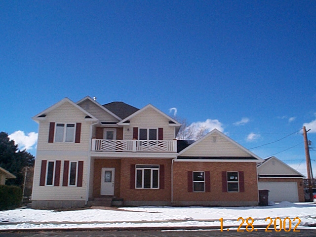 Total Photos: 1
|
| |
|
|
| Property Address: 286 S PALISADE - OREM |
|
| Mailing Address: %MCGRAW, TAMERA 463 E 200 N MAPLETON, UT 84664-3600 |
|
| Acreage: 0.08 |
|
| Last Document:
11270-1969
|
|
| Subdivision Map Filing |
|
| Taxing Description:
THE N1/2 LOT 22, PLAT A, FROD SUB.
*Taxing description NOT FOR LEGAL DOCUMENTS
|
|
- Owner Names
- Value History
- Tax History
- Location
- Photos
- Documents
- Aerial Image
| |
----- Real Estate Values ----- |
---Improvements--- |
---Greenbelt--- |
Total |
| Year |
Com |
Res |
Agr |
Tot |
Com |
Res |
Agr |
Tot |
Land |
Homesite |
Tot |
Market Value |
| 2001 |
$0 |
$0 |
$3,683 |
$3,683 |
$0 |
$0 |
$0 |
$0 |
$0 |
$0 |
$0 |
$3,683 |
| 2000 |
$0 |
$0 |
$3,442 |
$3,442 |
$0 |
$0 |
$0 |
$0 |
$0 |
$0 |
$0 |
$3,442 |
| 1999 |
$0 |
$0 |
$3,442 |
$3,442 |
$0 |
$0 |
$0 |
$0 |
$0 |
$0 |
$0 |
$3,442 |
| 1998 |
$0 |
$0 |
$3,442 |
$3,442 |
$0 |
$0 |
$0 |
$0 |
$0 |
$0 |
$0 |
$3,442 |
| 1997 |
$0 |
$0 |
$3,442 |
$3,442 |
$0 |
$0 |
$0 |
$0 |
$0 |
$0 |
$0 |
$3,442 |
| 1996 |
$0 |
$0 |
$3,442 |
$3,442 |
$0 |
$0 |
$0 |
$0 |
$0 |
$0 |
$0 |
$3,442 |
| 1995 |
$0 |
$0 |
$3,129 |
$3,129 |
$0 |
$0 |
$0 |
$0 |
$0 |
$0 |
$0 |
$3,129 |
| 1994 |
$0 |
$0 |
$1,830 |
$1,830 |
$0 |
$0 |
$0 |
$0 |
$0 |
$0 |
$0 |
$1,830 |
| 1993 |
$0 |
$0 |
$1,830 |
$1,830 |
$0 |
$0 |
$0 |
$0 |
$0 |
$0 |
$0 |
$1,830 |
| 1992 |
$0 |
$0 |
$1,679 |
$1,679 |
$0 |
$0 |
$0 |
$0 |
$0 |
$0 |
$0 |
$1,679 |
| 1991 |
$0 |
$0 |
$1,473 |
$1,473 |
$0 |
$0 |
$0 |
$0 |
$0 |
$0 |
$0 |
$1,473 |
| 1990 |
$0 |
$0 |
$1,473 |
$1,473 |
$0 |
$0 |
$0 |
$0 |
$0 |
$0 |
$0 |
$1,473 |
| 1989 |
$0 |
$0 |
$1,473 |
$1,473 |
$0 |
$0 |
$0 |
$0 |
$0 |
$0 |
$0 |
$1,473 |
| 1988 |
$0 |
$0 |
$1,474 |
$1,474 |
$0 |
$0 |
$0 |
$0 |
$0 |
$0 |
$0 |
$1,474 |
| 1987 |
$0 |
$0 |
$1,519 |
$1,519 |
$0 |
$0 |
$0 |
$0 |
$0 |
$0 |
$0 |
$1,519 |
| 1986 |
$0 |
$0 |
$1,519 |
$1,519 |
$0 |
$0 |
$0 |
$0 |
$0 |
$0 |
$0 |
$1,519 |
| 1985 |
$0 |
$0 |
$1,519 |
$1,519 |
$0 |
$0 |
$0 |
$0 |
$0 |
$0 |
$0 |
$1,519 |
| 1984 |
$0 |
$0 |
$1,531 |
$1,531 |
$0 |
$0 |
$0 |
$0 |
$0 |
$0 |
$0 |
$1,531 |
| Year |
General Taxes |
Adjustments |
Net Taxes |
Fees |
Payments |
Tax Balance* |
Balance Due |
Tax District |
| 2001 |
$37.98 |
$0.00 |
$37.98 |
$0.00 |
|
$0.00
|
$0.00 |
090 - OREM CITY |
| 2000 |
$36.70 |
$0.00 |
$36.70 |
$0.00 |
|
$0.00
|
$0.00 |
090 - OREM CITY |
| 1999 |
$37.78 |
$0.00 |
$37.78 |
$0.00 |
|
$0.00
|
$0.00 |
090 - OREM CITY |
| 1998 |
$35.67 |
$0.00 |
$35.67 |
$0.00 |
|
$0.00
|
$0.00 |
090 - OREM CITY |
| 1997 |
$35.52 |
$0.00 |
$35.52 |
$0.00 |
|
$0.00
|
$0.00 |
090 - OREM CITY |
| 1996 |
$32.45 |
$0.00 |
$32.45 |
$0.00 |
|
$0.00
|
$0.00 |
090 - OREM CITY |
| 1995 |
$33.39 |
$0.00 |
$33.39 |
$0.00 |
|
$0.00
|
$0.00 |
090 - OREM CITY |
| 1994 |
$25.16 |
$0.00 |
$25.16 |
$0.00 |
|
$0.00
|
$0.00 |
090 - OREM CITY |
| 1993 |
$21.49 |
$0.00 |
$21.49 |
$0.00 |
|
$0.00
|
$0.00 |
090 - OREM CITY |
| 1992 |
$19.94 |
$0.00 |
$19.94 |
$0.00 |
|
$0.00
|
$0.00 |
090 - OREM CITY |
| 1991 |
$18.28 |
$0.00 |
$18.28 |
$0.00 |
|
$0.00
|
$0.00 |
090 - OREM CITY |
| 1990 |
$16.46 |
$0.00 |
$16.46 |
$0.00 |
|
$0.00
|
$0.00 |
090 - OREM CITY |
| 1989 |
$16.78 |
$0.00 |
$16.78 |
$0.00 |
|
$0.00
|
$0.00 |
090 - OREM CITY |
| 1988 |
$16.75 |
$0.00 |
$16.75 |
$0.00 |
|
$0.00
|
$0.00 |
090 - OREM CITY |
| 1987 |
$16.98 |
$0.00 |
$16.98 |
$0.00 |
|
$0.00
|
$0.00 |
090 - OREM CITY |
| 1986 |
$16.75 |
$0.00 |
$16.75 |
$0.00 |
|
$0.00
|
$0.00 |
090 - OREM CITY |
| 1985 |
$16.85 |
$0.00 |
$16.85 |
$0.00 |
|
$0.00
|
$0.00 |
090 - OREM CITY |
| 1984 |
$16.66 |
$0.00 |
$16.66 |
$0.00 |
|
$0.00
|
$0.00 |
090 - OREM CITY |
* Note: Original tax amount (Does not include applicable interest and/or fees).
| Entry # |
Date |
Recorded |
Type |
Party1 (Grantor) |
Party2 (Grantee) |
| 12746-2001 |
02/13/2001 |
02/14/2001 |
WD |
L A CLINGO TRUST (ET AL) |
MC GRAW, TAMERA |
| 91482-1997 |
11/11/1997 |
11/18/1997 |
SP WD |
ANDERSON, CARL D & ROSALIN C |
ANDERSON, CARL D & ROSALIN C TEE |
Main Menu Comments or Concerns on Value/Appraisal - Assessor's Office
Documents/Owner/Parcel information - Recorder's Office
Address Change for Tax Notice
This page was created on 7/4/2025 5:33:05 PM |