Property Information
mobile view
| Serial Number: 40:326:0001 |
Serial Life: 2003... |
|
|
Total Photos: 1
|
| |
|
|
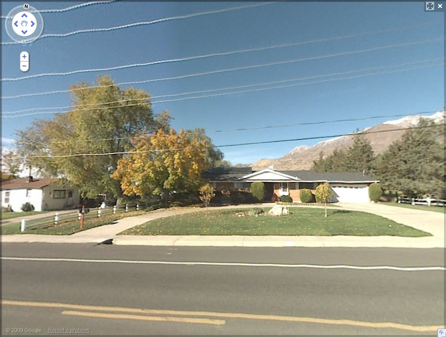
| Property Address: 157 E 1600 NORTH - OREM |
|
| Mailing Address: 157 E 1600 N OREM, UT 84057-2735 |
|
| Acreage: 0.448 |
|
| Last Document:
77678-2003
|
|
| Subdivision Map Filing |
|
| Taxing Description:
LOT 1, PLAT A, GOWAN SUBDV. AREA 0.448 AC.
*Taxing description NOT FOR LEGAL DOCUMENTS
|
|
- Owner Names
- Value History
- Tax History
- Location
- Photos
- Documents
- Aerial Image
| 2024... |
|
HAMMOND, ANNIE |
|
| 2024... |
|
HAMMOND, JONATHAN |
|
| 2024NV |
|
FLOYD H GOWANS 2023 TRUST 06-01-2023 THE |
|
| 2024NV |
|
GOWANS, JAMES |
|
| 2024NV |
|
MESSINA, CAROL |
|
| 2024NV |
|
FLOYD H GOWANS 2023 TRUST 06-01-2023 THE |
|
| 2024NV |
|
GOWANS, FLOYD H |
|
| 2024NV |
|
GOWANS, FLOYD H |
|
| 2004-2023 |
|
GOWANS, FLOYD H |
|
| 2004-2023 |
|
GOWANS, SHANNON H |
|
| 2003 |
|
EVANS, ALICE G |
|
| 2003 |
|
EVANS, JOHN W |
|
| 2003 |
|
GOWANS, FLOYD H |
|
| 2003 |
|
GOWANS, FREDERICK R |
|
| 2003 |
|
GOWANS, GLORIA R |
|
| 2003 |
|
GOWANS, SHANNON H |
|
| |
----- Real Estate Values ----- |
---Improvements--- |
---Greenbelt--- |
Total |
| Year |
Com |
Res |
Agr |
Tot |
Com |
Res |
Agr |
Tot |
Land |
Homesite |
Tot |
Market Value |
| 2024 |
$0 |
$263,100 |
$0 |
$263,100 |
$0 |
$273,300 |
$0 |
$273,300 |
$0 |
$0 |
$0 |
$536,400 |
| 2023 |
$0 |
$263,100 |
$0 |
$263,100 |
$0 |
$275,000 |
$0 |
$275,000 |
$0 |
$0 |
$0 |
$538,100 |
| 2022 |
$0 |
$280,500 |
$0 |
$280,500 |
$0 |
$234,300 |
$0 |
$234,300 |
$0 |
$0 |
$0 |
$514,800 |
| 2021 |
$0 |
$165,000 |
$0 |
$165,000 |
$0 |
$209,200 |
$0 |
$209,200 |
$0 |
$0 |
$0 |
$374,200 |
| 2020 |
$0 |
$132,000 |
$0 |
$132,000 |
$0 |
$205,100 |
$0 |
$205,100 |
$0 |
$0 |
$0 |
$337,100 |
| 2019 |
$0 |
$132,000 |
$0 |
$132,000 |
$0 |
$179,200 |
$0 |
$179,200 |
$0 |
$0 |
$0 |
$311,200 |
| 2018 |
$0 |
$124,500 |
$0 |
$124,500 |
$0 |
$179,200 |
$0 |
$179,200 |
$0 |
$0 |
$0 |
$303,700 |
| 2017 |
$0 |
$96,400 |
$0 |
$96,400 |
$0 |
$179,200 |
$0 |
$179,200 |
$0 |
$0 |
$0 |
$275,600 |
| 2016 |
$0 |
$86,300 |
$0 |
$86,300 |
$0 |
$155,800 |
$0 |
$155,800 |
$0 |
$0 |
$0 |
$242,100 |
| 2015 |
$0 |
$83,800 |
$0 |
$83,800 |
$0 |
$152,300 |
$0 |
$152,300 |
$0 |
$0 |
$0 |
$236,100 |
| 2014 |
$0 |
$81,300 |
$0 |
$81,300 |
$0 |
$138,200 |
$0 |
$138,200 |
$0 |
$0 |
$0 |
$219,500 |
| 2013 |
$0 |
$69,200 |
$0 |
$69,200 |
$0 |
$129,500 |
$0 |
$129,500 |
$0 |
$0 |
$0 |
$198,700 |
| 2012 |
$0 |
$74,100 |
$0 |
$74,100 |
$0 |
$129,100 |
$0 |
$129,100 |
$0 |
$0 |
$0 |
$203,200 |
| 2011 |
$0 |
$88,900 |
$0 |
$88,900 |
$0 |
$120,500 |
$0 |
$120,500 |
$0 |
$0 |
$0 |
$209,400 |
| 2010 |
$0 |
$105,692 |
$0 |
$105,692 |
$0 |
$116,860 |
$0 |
$116,860 |
$0 |
$0 |
$0 |
$222,552 |
| 2009 |
$0 |
$114,200 |
$0 |
$114,200 |
$0 |
$110,600 |
$0 |
$110,600 |
$0 |
$0 |
$0 |
$224,800 |
| 2008 |
$0 |
$114,200 |
$0 |
$114,200 |
$0 |
$153,400 |
$0 |
$153,400 |
$0 |
$0 |
$0 |
$267,600 |
| 2007 |
$0 |
$119,000 |
$0 |
$119,000 |
$0 |
$159,800 |
$0 |
$159,800 |
$0 |
$0 |
$0 |
$278,800 |
| 2006 |
$0 |
$51,500 |
$0 |
$51,500 |
$0 |
$124,800 |
$0 |
$124,800 |
$0 |
$0 |
$0 |
$176,300 |
| 2005 |
$0 |
$49,000 |
$0 |
$49,000 |
$0 |
$118,859 |
$0 |
$118,859 |
$0 |
$0 |
$0 |
$167,859 |
| 2004 |
$0 |
$49,000 |
$0 |
$49,000 |
$0 |
$118,859 |
$0 |
$118,859 |
$0 |
$0 |
$0 |
$167,859 |
| 2003 |
$0 |
$49,000 |
$0 |
$49,000 |
$0 |
$118,859 |
$0 |
$118,859 |
$0 |
$0 |
$0 |
$167,859 |
| Year |
General Taxes |
Adjustments |
Net Taxes |
Fees |
Payments |
Tax Balance* |
Balance Due |
Tax District |
| 2025 |
$0.00 |
$0.00 |
$0.00 |
$0.00 |
|
$0.00
|
$0.00 |
090 - OREM CITY |
| 2024 |
$0.00 |
$0.00 |
$0.00 |
$0.00 |
|
$0.00
|
$0.00 |
090 - OREM CITY |
| 2023 |
$2,251.92 |
$0.00 |
$2,251.92 |
$0.00 |
|
$0.00
|
$0.00 |
090 - OREM CITY |
| 2022 |
$2,223.78 |
$0.00 |
$2,223.78 |
$0.00 |
|
$0.00
|
$0.00 |
090 - OREM CITY |
| 2021 |
$1,940.38 |
$0.00 |
$1,940.38 |
$0.00 |
|
$0.00
|
$0.00 |
090 - OREM CITY |
| 2020 |
$1,778.59 |
$0.00 |
$1,778.59 |
$0.00 |
|
$0.00
|
$0.00 |
090 - OREM CITY |
| 2019 |
$1,578.95 |
$0.00 |
$1,578.95 |
$0.00 |
|
$0.00
|
$0.00 |
090 - OREM CITY |
| 2018 |
$1,612.72 |
$0.00 |
$1,612.72 |
$0.00 |
|
$0.00
|
$0.00 |
090 - OREM CITY |
| 2017 |
$1,502.61 |
$0.00 |
$1,502.61 |
$0.00 |
|
$0.00
|
$0.00 |
090 - OREM CITY |
| 2016 |
$1,431.42 |
$0.00 |
$1,431.42 |
$0.00 |
|
$0.00
|
$0.00 |
090 - OREM CITY |
| 2015 |
$1,476.06 |
$0.00 |
$1,476.06 |
$0.00 |
|
$0.00
|
$0.00 |
090 - OREM CITY |
| 2014 |
$1,378.56 |
$0.00 |
$1,378.56 |
$0.00 |
|
$0.00
|
$0.00 |
090 - OREM CITY |
| 2013 |
$1,345.74 |
$0.00 |
$1,345.74 |
$0.00 |
|
$0.00
|
$0.00 |
090 - OREM CITY |
| 2012 |
$1,404.60 |
$0.00 |
$1,404.60 |
$0.00 |
|
$0.00
|
$0.00 |
090 - OREM CITY |
| 2011 |
$1,440.55 |
$0.00 |
$1,440.55 |
$0.00 |
|
$0.00
|
$0.00 |
090 - OREM CITY |
| 2010 |
$1,433.35 |
$0.00 |
$1,433.35 |
$0.00 |
|
$0.00
|
$0.00 |
090 - OREM CITY |
| 2009 |
$1,342.11 |
$0.00 |
$1,342.11 |
$0.00 |
|
$0.00
|
$0.00 |
090 - OREM CITY |
| 2008 |
$1,480.48 |
$0.00 |
$1,480.48 |
$0.00 |
|
$0.00
|
$0.00 |
090 - OREM CITY |
| 2007 |
$1,524.81 |
$0.00 |
$1,524.81 |
$0.00 |
|
$0.00
|
$0.00 |
090 - OREM CITY |
| 2006 |
$1,026.76 |
$0.00 |
$1,026.76 |
$0.00 |
|
$0.00
|
$0.00 |
090 - OREM CITY |
| 2005 |
$1,103.43 |
$0.00 |
$1,103.43 |
$0.00 |
|
$0.00
|
$0.00 |
090 - OREM CITY |
| 2004 |
$1,083.86 |
$0.00 |
$1,083.86 |
$0.00 |
|
$0.00
|
$0.00 |
090 - OREM CITY |
| 2003 |
$1,051.73 |
$0.00 |
$1,051.73 |
$0.00 |
|
$0.00
|
$0.00 |
090 - OREM CITY |
* Note: Original tax amount (Does not include applicable interest and/or fees).
| Entry # |
Date |
Recorded |
Type |
Party1 (Grantor) |
Party2 (Grantee) |
| 74119-2023 |
11/09/2023 |
11/13/2023 |
D TR |
HAMMOND, ANNIE & JONATHAN BY ATY |
CMG MORTGAGE INC DBA (ET AL) |
| 74118-2023 |
11/09/2023 |
11/13/2023 |
SP PA |
HAMMOND, JONATHAN & ANNIE |
HAMMOND, HANNAH |
| 74057-2023 |
11/06/2023 |
11/13/2023 |
WD |
GOWANS, JAMES SUCTEE (ET AL) |
HAMMOND, JONATHAN & ANNIE |
| 74056-2023 |
11/06/2023 |
11/13/2023 |
AF DC |
GOWANS, FLOYD HILL & FLOYD H AKA (ET AL) |
GOWANS, JAMES SUCTEE (ET AL) |
| 42031-2023 |
06/01/2023 |
06/28/2023 |
WD |
GOWANS, FLOYD H |
GOWANS, FLOYD H TEE (ET AL) |
| 42030-2023 |
06/28/2023 |
06/28/2023 |
AF DC |
GOWANS, SHANNON H DEC |
WHOM OF INTEREST |
| 77678-2003 |
05/21/2003 |
05/22/2003 |
WD |
GOWANS, FREDERICK R & GLORIA R (ET AL) |
GOWANS, FLOYD H & SHANNON H |
| 92098-2002 |
08/08/2002 |
08/12/2002 |
S PLAT |
EVANS, ALICE G & JOHN W (ET AL) |
GOWAN PLAT A |
Main Menu Comments or Concerns on Value/Appraisal - Assessor's Office
Documents/Owner/Parcel information - Recorder's Office
Address Change for Tax Notice
This page was created on 7/26/2024 3:30:16 AM |