Property Information
mobile view
| Serial Number: 41:836:0045 |
Serial Life: 2017... |
|
|
 Total Photos: 5
|
| |
|
|
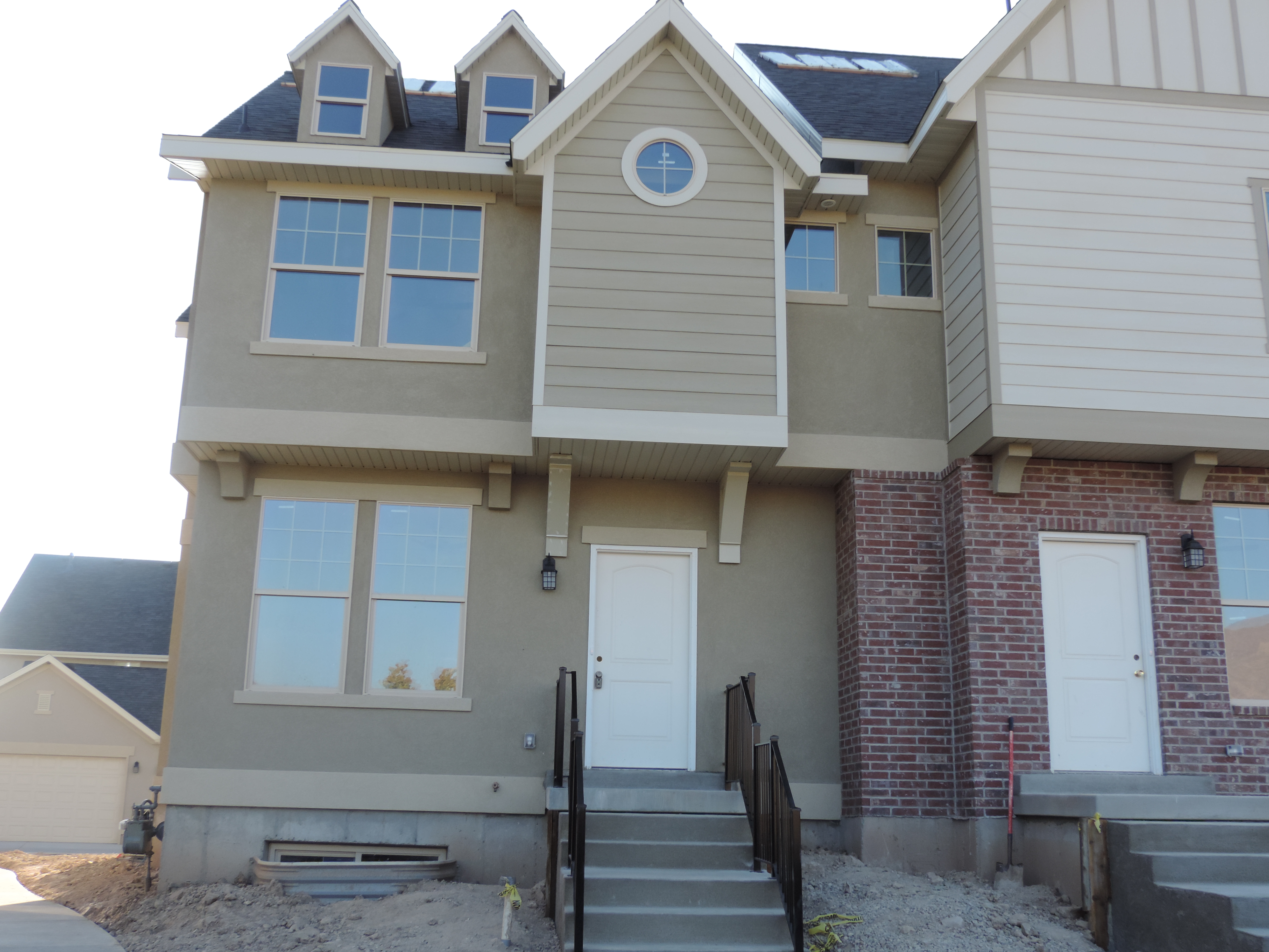
| Property Address: 2079 W CRESCENT ROW - MAPLETON |
|
| Mailing Address: 1325 W PARK MEADOWS DR MAPLETON, UT 84664-4834 |
|
| Acreage: 0.076164 |
|
| Last Document:
66558-2016
|
|
| Subdivision Map Filing |
|
| Taxing Description:
LOT M45, PLAT K, HARVEST PARK PUD SUB AREA 0.076 AC.
*Taxing description NOT FOR LEGAL DOCUMENTS
|
|
- Owner Names
- Value History
- Tax History
- Location
- Photos
- Documents
- Aerial Image
| |
----- Real Estate Values ----- |
---Improvements--- |
---Greenbelt--- |
Total |
| Year |
Com |
Res |
Agr |
Tot |
Com |
Res |
Agr |
Tot |
Land |
Homesite |
Tot |
Market Value |
| 2024 |
$0 |
$58,900 |
$0 |
$58,900 |
$0 |
$341,600 |
$0 |
$341,600 |
$0 |
$0 |
$0 |
$400,500 |
| 2023 |
$0 |
$58,600 |
$0 |
$58,600 |
$0 |
$340,200 |
$0 |
$340,200 |
$0 |
$0 |
$0 |
$398,800 |
| 2022 |
$0 |
$56,700 |
$0 |
$56,700 |
$0 |
$298,600 |
$0 |
$298,600 |
$0 |
$0 |
$0 |
$355,300 |
| 2021 |
$0 |
$42,600 |
$0 |
$42,600 |
$0 |
$241,400 |
$0 |
$241,400 |
$0 |
$0 |
$0 |
$284,000 |
| 2020 |
$0 |
$51,100 |
$0 |
$51,100 |
$0 |
$232,900 |
$0 |
$232,900 |
$0 |
$0 |
$0 |
$284,000 |
| 2019 |
$0 |
$51,100 |
$0 |
$51,100 |
$0 |
$232,900 |
$0 |
$232,900 |
$0 |
$0 |
$0 |
$284,000 |
| 2018 |
$0 |
$47,500 |
$0 |
$47,500 |
$0 |
$227,500 |
$0 |
$227,500 |
$0 |
$0 |
$0 |
$275,000 |
| 2017 |
$0 |
$45,000 |
$0 |
$45,000 |
$0 |
$0 |
$0 |
$0 |
$0 |
$0 |
$0 |
$45,000 |
| Year |
General Taxes |
Adjustments |
Net Taxes |
Fees |
Payments |
Tax Balance* |
Balance Due |
Tax District |
| 2025 |
$0.00 |
$0.00 |
$0.00 |
$0.00 |
|
$0.00
|
$0.00 |
140 - MAPLETON CITY |
| 2024 |
$2,248.57 |
$0.00 |
$2,248.57 |
$0.00 |
|
$0.00
|
$0.00 |
140 - MAPLETON CITY |
| 2023 |
$2,224.98 |
$0.00 |
$2,224.98 |
$0.00 |
|
$0.00
|
$0.00 |
140 - MAPLETON CITY |
| 2022 |
$2,004.76 |
$0.00 |
$2,004.76 |
$0.00 |
|
$0.00
|
$0.00 |
140 - MAPLETON CITY |
| 2021 |
$1,897.67 |
$0.00 |
$1,897.67 |
$0.00 |
|
$0.00
|
$0.00 |
140 - MAPLETON CITY |
| 2020 |
$1,961.87 |
$0.00 |
$1,961.87 |
$0.00 |
|
$0.00
|
$0.00 |
140 - MAPLETON CITY |
| 2019 |
$1,922.04 |
$0.00 |
$1,922.04 |
$0.00 |
|
$0.00
|
$0.00 |
140 - MAPLETON CITY |
| 2018 |
$1,955.06 |
$0.00 |
$1,955.06 |
$0.00 |
|
$0.00
|
$0.00 |
140 - MAPLETON CITY |
| 2017 |
$602.82 |
$0.00 |
$602.82 |
$0.00 |
|
$0.00
|
$0.00 |
140 - MAPLETON CITY |
* Note: Original tax amount (Does not include applicable interest and/or fees).
| Entry # |
Date |
Recorded |
Type |
Party1 (Grantor) |
Party2 (Grantee) |
| 103237-2022 |
09/23/2022 |
09/23/2022 |
WD |
LIBERTY & JUSTICE LLC |
BO & JAX LLC |
| 77756-2018 |
08/01/2018 |
08/16/2018 |
N |
MAPLETON CITY CORPORATION |
WHOM OF INTEREST |
| 105262-2017 |
10/23/2017 |
10/24/2017 |
WD |
SALISBURY, JAMES & JANIS |
LIBERTY & JUSTICE LLC |
| 10984-2017 |
12/22/2016 |
02/02/2017 |
GEO HAZ |
SAUSBURY, JIM |
MAPLETON CITY CORPORATION |
| 119608-2016 |
11/17/2016 |
11/29/2016 |
ADECCOV |
HARVEST PARK HOMEOWNERS ASSOCIATION INC |
WHOM OF INTEREST |
| 70992-2016 |
07/27/2016 |
07/29/2016 |
WD |
LAKES RESIDENY LLC (ET AL) |
SALISBURY, JAMES & JANIS AN INT (ET AL) |
| 66558-2016 |
10/08/2013 |
07/20/2016 |
S PLAT |
METLER BROTHERS CONSTRUCTION INC (ET AL) |
HARVEST PARK PLAT K |
Main Menu Comments or Concerns on Value/Appraisal - Assessor's Office
Documents/Owner/Parcel information - Recorder's Office
Address Change for Tax Notice
This page was created on 2/20/2025 9:45:58 PM |


