Property Information
mobile view
| Serial Number: 45:018:0012 |
Serial Life: 2013... |
|
|
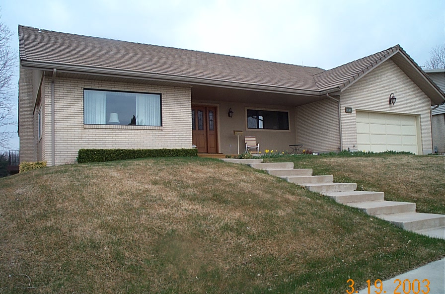 Total Photos: 1
|
| |
|
|
| Property Address: 302 W 1700 SOUTH - OREM |
|
| Mailing Address: 302 W 1700 S OREM, UT 84058-7542 |
|
| Acreage: 0.27573 |
|
| Last Document:
93705-2022
|
|
| Subdivision Map Filing |
|
| Taxing Description:
LOT 29, PLAT C, LAKEWOOD VILLAGE SUBDV. AREA 0.220 AC. ALSO COM S 529.46 FT & W 2060.76 FT FR E 1/4 COR. SEC. 27, T6S, R2E, SLB&M.; N 4 DEG 35' 49" W 38.58 FT; N 59 DEG 39' 20" E 22.2 FT; S 4 DEG 35' 48" E 48.23 FT; S 85 DEG 24' 16" W 20 FT TO BEG. AREA 0.020 AC. ALSO COM S 0 DEG 39' 35" E 529.51 FT & S 89 DEG 20' 25" W 2060.9 FT FR E 1/4 COR. SEC. 27, T6S, R2E, SLB&M.; S 84 DEG 37' 53" W 80 FT; N 58 DEG 53' 14" E 88.82 FT; S 5 DEG 21' 57" E 38.58 FT TO BEG. AREA 0.035 AC. TOTAL AREA .276 AC.
*Taxing description NOT FOR LEGAL DOCUMENTS
|
|
- Owner Names
- Value History
- Tax History
- Location
- Photos
- Documents
- Aerial Image
| |
----- Real Estate Values ----- |
---Improvements--- |
---Greenbelt--- |
Total |
| Year |
Com |
Res |
Agr |
Tot |
Com |
Res |
Agr |
Tot |
Land |
Homesite |
Tot |
Market Value |
| 2024 |
$0 |
$225,300 |
$0 |
$225,300 |
$0 |
$421,200 |
$0 |
$421,200 |
$0 |
$0 |
$0 |
$646,500 |
| 2023 |
$0 |
$225,300 |
$0 |
$225,300 |
$0 |
$406,800 |
$0 |
$406,800 |
$0 |
$0 |
$0 |
$632,100 |
| 2022 |
$0 |
$240,200 |
$0 |
$240,200 |
$0 |
$346,600 |
$0 |
$346,600 |
$0 |
$0 |
$0 |
$586,800 |
| 2021 |
$0 |
$141,300 |
$0 |
$141,300 |
$0 |
$320,900 |
$0 |
$320,900 |
$0 |
$0 |
$0 |
$462,200 |
| 2020 |
$0 |
$113,000 |
$0 |
$113,000 |
$0 |
$311,600 |
$0 |
$311,600 |
$0 |
$0 |
$0 |
$424,600 |
| 2019 |
$0 |
$97,900 |
$0 |
$97,900 |
$0 |
$292,000 |
$0 |
$292,000 |
$0 |
$0 |
$0 |
$389,900 |
| 2018 |
$0 |
$94,100 |
$0 |
$94,100 |
$0 |
$268,200 |
$0 |
$268,200 |
$0 |
$0 |
$0 |
$362,300 |
| 2017 |
$0 |
$86,600 |
$0 |
$86,600 |
$0 |
$237,600 |
$0 |
$237,600 |
$0 |
$0 |
$0 |
$324,200 |
| 2016 |
$0 |
$75,300 |
$0 |
$75,300 |
$0 |
$245,300 |
$0 |
$245,300 |
$0 |
$0 |
$0 |
$320,600 |
| 2015 |
$0 |
$75,300 |
$0 |
$75,300 |
$0 |
$223,400 |
$0 |
$223,400 |
$0 |
$0 |
$0 |
$298,700 |
| 2014 |
$0 |
$77,600 |
$0 |
$77,600 |
$0 |
$201,300 |
$0 |
$201,300 |
$0 |
$0 |
$0 |
$278,900 |
| 2013 |
$0 |
$79,500 |
$0 |
$79,500 |
$0 |
$175,000 |
$0 |
$175,000 |
$0 |
$0 |
$0 |
$254,500 |
| Year |
General Taxes |
Adjustments |
Net Taxes |
Fees |
Payments |
Tax Balance* |
Balance Due |
Tax District |
| 2025 |
$0.00 |
$0.00 |
$0.00 |
$0.00 |
|
$0.00
|
$0.00 |
090 - OREM CITY |
| 2024 |
$0.00 |
$0.00 |
$0.00 |
$0.00 |
|
$0.00
|
$0.00 |
090 - OREM CITY |
| 2023 |
$2,645.31 |
$0.00 |
$2,645.31 |
$0.00 |
|
$0.00
|
$0.00 |
090 - OREM CITY |
| 2022 |
$2,534.80 |
$0.00 |
$2,534.80 |
$0.00 |
|
$0.00
|
$0.00 |
090 - OREM CITY |
| 2021 |
$2,396.69 |
$0.00 |
$2,396.69 |
$0.00 |
|
$0.00
|
$0.00 |
090 - OREM CITY |
| 2020 |
$2,240.25 |
$0.00 |
$2,240.25 |
$0.00 |
|
$0.00
|
$0.00 |
090 - OREM CITY |
| 2019 |
$1,978.26 |
$0.00 |
$1,978.26 |
$0.00 |
|
$0.00
|
$0.00 |
090 - OREM CITY |
| 2018 |
$1,923.90 |
$0.00 |
$1,923.90 |
$0.00 |
|
$0.00
|
$0.00 |
090 - OREM CITY |
| 2017 |
$1,767.59 |
$0.00 |
$1,767.59 |
$0.00 |
|
$0.00
|
$0.00 |
090 - OREM CITY |
| 2016 |
$1,895.55 |
$0.00 |
$1,895.55 |
$0.00 |
|
$0.00
|
$0.00 |
090 - OREM CITY |
| 2015 |
$1,867.43 |
$0.00 |
$1,867.43 |
$0.00 |
|
$0.00
|
$0.00 |
090 - OREM CITY |
| 2014 |
$1,751.62 |
$0.00 |
$1,751.62 |
$0.00 |
|
$0.00
|
$0.00 |
090 - OREM CITY |
| 2013 |
$1,723.65 |
$0.00 |
$1,723.65 |
$0.00 |
|
$0.00
|
$0.00 |
090 - OREM CITY |
* Note: Original tax amount (Does not include applicable interest and/or fees).
| Entry # |
Date |
Recorded |
Type |
Party1 (Grantor) |
Party2 (Grantee) |
| 93705-2022 |
02/06/2022 |
08/24/2022 |
WD |
HIRSCHI, WILLARD MORGAN & BARBARA JO TEE (ET AL) |
WILKES, CAROLYN HIRSCHI TEE (ET AL) |
| 42431-2012 |
05/18/2012 |
05/22/2012 |
WD |
HIRSCHI, WILLARD MORGAN & BARBARA JO TEE (ET AL) |
HIRSCHI, WILLARD MORGAN & BARBARA JO TEE |
Main Menu Comments or Concerns on Value/Appraisal - Assessor's Office
Documents/Owner/Parcel information - Recorder's Office
Address Change for Tax Notice
This page was created on 8/21/2024 8:44:33 AM |