Property Information
mobile view
| Serial Number: 45:241:0026 |
Serial Life: 2015... |
|
|
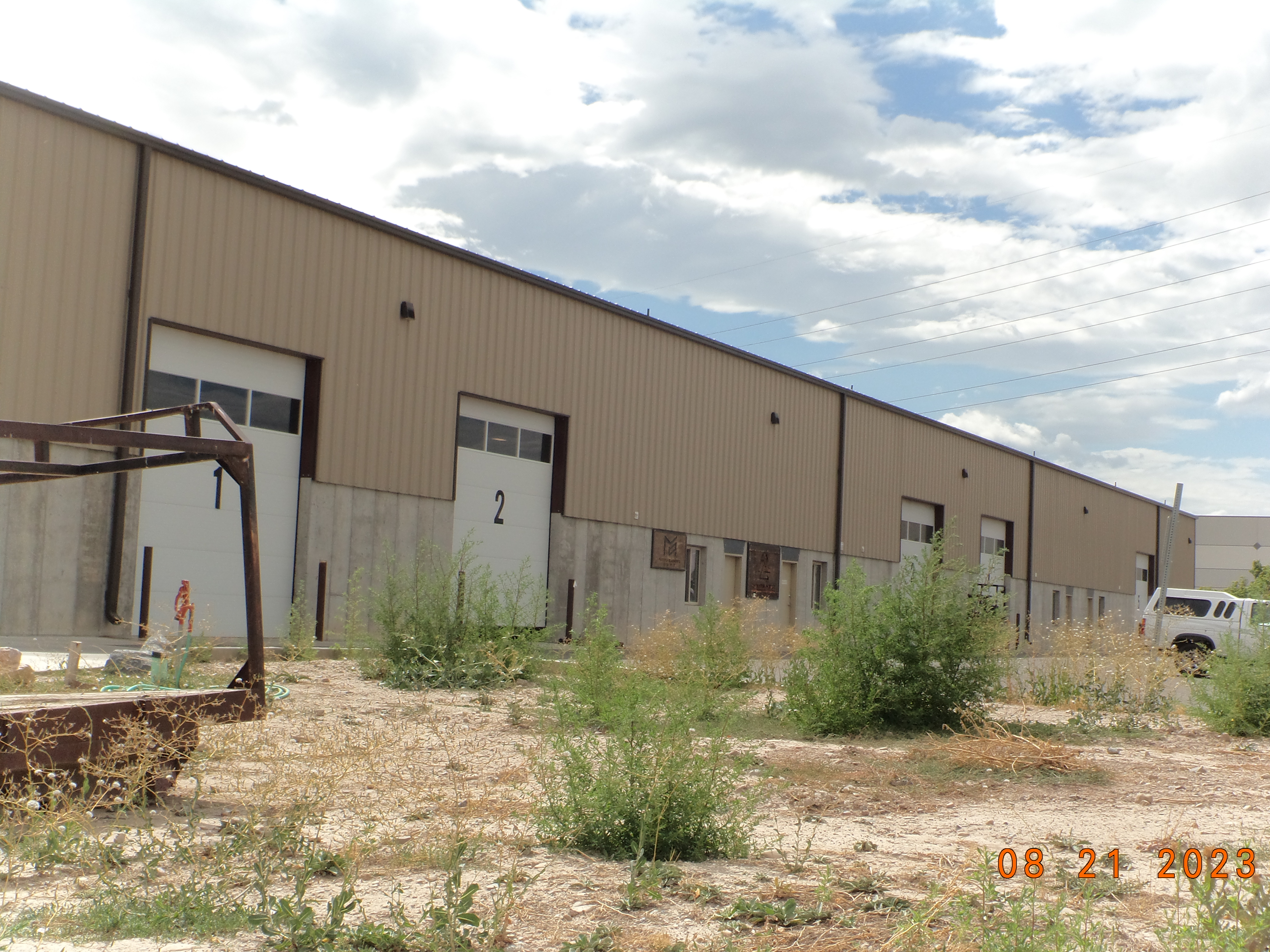 Total Photos: 9
|
| |
|
|
| Property Address: 1279 W 300 SOUTH Unit# 1-6 - LINDON |
|
| Mailing Address: 235 N 200 E LINDON, UT 84042-1404 |
|
| Acreage: 2.214419 |
|
| Last Document:
11735-2014
|
|
| Subdivision Map Filing |
|
| Taxing Description:
PART LOT 5, PLAT A, LINDON HARBOR INDUSTRIAL PARK SUB DESCRIBED AS FOLLOWS; COM S 792.83 FT & W 424.07 FT FR N 1/4 COR. SEC. 5, T6S, R2E, SLB&M.; E 200 FT; S 510.73 FT; ALONG A CURVE TO R (CHORD BEARS: N 74 DEG 41' 51" W 7.75 FT, RADIUS = 492 FT); N 74 DEG 14' 48" W 200.04 FT; N 454.37 FT TO BEG. AREA 2.214 AC.
*Taxing description NOT FOR LEGAL DOCUMENTS
|
|
- Owner Names
- Value History
- Tax History
- Location
- Photos
- Documents
- Aerial Image
| |
----- Real Estate Values ----- |
---Improvements--- |
---Greenbelt--- |
Total |
| Year |
Com |
Res |
Agr |
Tot |
Com |
Res |
Agr |
Tot |
Land |
Homesite |
Tot |
Market Value |
| 2025 |
$664,500 |
$0 |
$0 |
$664,500 |
$962,800 |
$0 |
$0 |
$962,800 |
$0 |
$0 |
$0 |
$1,627,300 |
| 2024 |
$652,600 |
$0 |
$0 |
$652,600 |
$974,800 |
$0 |
$0 |
$974,800 |
$0 |
$0 |
$0 |
$1,627,400 |
| 2023 |
$605,200 |
$0 |
$0 |
$605,200 |
$765,500 |
$0 |
$0 |
$765,500 |
$0 |
$0 |
$0 |
$1,370,700 |
| 2022 |
$480,600 |
$0 |
$0 |
$480,600 |
$724,100 |
$0 |
$0 |
$724,100 |
$0 |
$0 |
$0 |
$1,204,700 |
| 2021 |
$480,600 |
$0 |
$0 |
$480,600 |
$631,400 |
$0 |
$0 |
$631,400 |
$0 |
$0 |
$0 |
$1,112,000 |
| 2020 |
$480,600 |
$0 |
$0 |
$480,600 |
$588,600 |
$0 |
$0 |
$588,600 |
$0 |
$0 |
$0 |
$1,069,200 |
| 2019 |
$445,000 |
$0 |
$0 |
$445,000 |
$110,000 |
$0 |
$0 |
$110,000 |
$0 |
$0 |
$0 |
$555,000 |
| 2018 |
$397,400 |
$0 |
$0 |
$397,400 |
$0 |
$0 |
$0 |
$0 |
$0 |
$0 |
$0 |
$397,400 |
| 2017 |
$379,100 |
$0 |
$0 |
$379,100 |
$0 |
$0 |
$0 |
$0 |
$0 |
$0 |
$0 |
$379,100 |
| 2016 |
$357,000 |
$0 |
$0 |
$357,000 |
$0 |
$0 |
$0 |
$0 |
$0 |
$0 |
$0 |
$357,000 |
| 2015 |
$350,000 |
$0 |
$0 |
$350,000 |
$0 |
$0 |
$0 |
$0 |
$0 |
$0 |
$0 |
$350,000 |
| Year |
General Taxes |
Adjustments |
Net Taxes |
Fees |
Payments |
Tax Balance* |
Balance Due |
Tax District |
| 2025 |
$0.00 |
$0.00 |
$0.00 |
$0.00 |
|
$0.00
|
$0.00 |
085 - LINDON CITY W/WATER CONS |
| 2024 |
$13,221.00 |
$0.00 |
$13,221.00 |
$0.00 |
|
$0.00
|
$0.00 |
085 - LINDON CITY W/WATER CONS |
| 2023 |
$10,367.97 |
$0.00 |
$10,367.97 |
$0.00 |
|
$0.00
|
$0.00 |
085 - LINDON CITY W/WATER CONS |
| 2022 |
$9,432.80 |
$0.00 |
$9,432.80 |
$0.00 |
|
$0.00
|
$0.00 |
085 - LINDON CITY W/WATER CONS |
| 2021 |
$10,499.50 |
$0.00 |
$10,499.50 |
$0.00 |
|
$0.00
|
$0.00 |
085 - LINDON CITY W/WATER CONS |
| 2020 |
$10,255.77 |
$0.00 |
$10,255.77 |
$0.00 |
|
$0.00
|
$0.00 |
085 - LINDON CITY W/WATER CONS |
| 2019 |
$5,103.78 |
$0.00 |
$5,103.78 |
$0.00 |
|
$0.00
|
$0.00 |
085 - LINDON CITY W/WATER CONS |
| 2018 |
$3,876.64 |
$0.00 |
$3,876.64 |
$0.00 |
|
$0.00
|
$0.00 |
085 - LINDON CITY W/WATER CONS |
| 2017 |
$3,794.03 |
$0.00 |
$3,794.03 |
$0.00 |
|
$0.00
|
$0.00 |
085 - LINDON CITY W/WATER CONS |
| 2016 |
$4,164.62 |
($301.88) |
$3,862.74 |
$0.00 |
|
$0.00
|
$0.00 |
085 - LINDON CITY W/WATER CONS |
| 2015 |
$5,277.29 |
($1,271.54) |
$4,005.75 |
$0.00 |
|
$0.00
|
$0.00 |
085 - LINDON CITY W/WATER CONS |
* Note: Original tax amount (Does not include applicable interest and/or fees).
| Entry # |
Date |
Recorded |
Type |
Party1 (Grantor) |
Party2 (Grantee) |
| 122723-2021 |
05/14/2021 |
07/12/2021 |
REC |
ROCK CANYON BANK TEE |
L C D LAMOREAUX LLC |
| 54115-2020 |
04/24/2020 |
04/24/2020 |
D TR |
L C D LAMOREAUX LLC |
ROCK CANYON BANK |
| 11736-2014 |
10/24/2011 |
02/21/2014 |
EAS |
L C D LAMOREAUX LLC |
LINDON CITY CORPORATION |
| 11735-2014 |
10/24/2011 |
02/21/2014 |
WD |
L C D LAMOREAUX LLC |
LINDON CITY CORPORATION |
Main Menu Comments or Concerns on Value/Appraisal - Assessor's Office
Documents/Owner/Parcel information - Recorder's Office
Address Change for Tax Notice
This page was created on 5/10/2025 3:17:32 PM |


