Property Information
mobile view
| Serial Number: 47:030:0013 |
Serial Life: 1980-1991 |
|
|
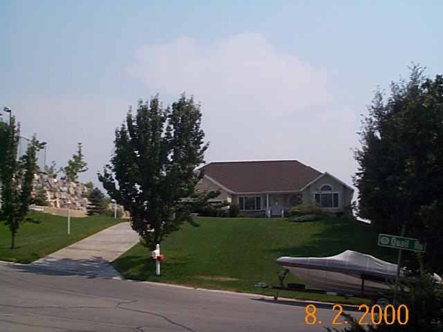 Total Photos: 1
|
| |
|
|
| Property Address: 576 E QUAIL RD - OREM |
|
| Mailing Address: 576 E 1700 N OREM, UT 84097 |
|
| Acreage: 0.41 |
|
| Last Document:
0-0
|
|
| Subdivision Map Filing |
|
| Taxing Description:
LOT 12, PLAT A, NORTH RIDGE PLANNED UNIT DEV. ALSO: COM AT NE COR LOT 12, PLAT A, NORTHRIDGE PLANNED DEV., OREM; S 1 53'53"E ALONG E LINE OF SD LOT 12, 112.92 FT; N 88 12"W ALONG S LINE OF SD LOT 12, 83 FT; S 8 42'37"E 53.47 FT S 62 26'11"E 117.77 FT; N 8 42'37"W 219.85 FT TO BEG. SUBJ TO EASEMENTS.
*Taxing description NOT FOR LEGAL DOCUMENTS
|
|
- Owner Names
- Value History
- Tax History
- Location
- Photos
- Documents
- Aerial Image
| |
----- Real Estate Values ----- |
---Improvements--- |
---Greenbelt--- |
Total |
| Year |
Com |
Res |
Agr |
Tot |
Com |
Res |
Agr |
Tot |
Land |
Homesite |
Tot |
Market Value |
| 1991 |
$0 |
$25,551 |
$0 |
$25,551 |
$0 |
$112,650 |
$0 |
$112,650 |
$0 |
$0 |
$0 |
$138,201 |
| 1990 |
$0 |
$25,551 |
$0 |
$25,551 |
$0 |
$112,650 |
$0 |
$112,650 |
$0 |
$0 |
$0 |
$138,201 |
| 1989 |
$0 |
$25,551 |
$0 |
$25,551 |
$0 |
$112,650 |
$0 |
$112,650 |
$0 |
$0 |
$0 |
$138,201 |
| 1988 |
$0 |
$25,552 |
$0 |
$25,552 |
$0 |
$112,650 |
$0 |
$112,650 |
$0 |
$0 |
$0 |
$138,202 |
| 1987 |
$0 |
$26,342 |
$0 |
$26,342 |
$0 |
$116,133 |
$0 |
$116,133 |
$0 |
$0 |
$0 |
$142,475 |
| 1986 |
$0 |
$26,342 |
$0 |
$26,342 |
$0 |
$116,136 |
$0 |
$116,136 |
$0 |
$0 |
$0 |
$142,478 |
| 1985 |
$0 |
$26,342 |
$0 |
$26,342 |
$0 |
$116,133 |
$0 |
$116,133 |
$0 |
$0 |
$0 |
$142,475 |
| 1984 |
$0 |
$26,608 |
$0 |
$26,608 |
$0 |
$117,308 |
$0 |
$117,308 |
$0 |
$0 |
$0 |
$143,916 |
| Year |
General Taxes |
Adjustments |
Net Taxes |
Fees |
Payments |
Tax Balance* |
Balance Due |
Tax District |
| 1991 |
$1,205.47 |
$0.00 |
$1,205.47 |
$0.00 |
|
$0.00
|
$0.00 |
090 - OREM CITY |
| 1990 |
$1,158.82 |
$0.00 |
$1,158.82 |
$0.00 |
|
$0.00
|
$0.00 |
090 - OREM CITY |
| 1989 |
$1,181.04 |
$0.00 |
$1,181.04 |
$0.00 |
|
$0.00
|
$0.00 |
090 - OREM CITY |
| 1988 |
$1,178.22 |
$0.00 |
$1,178.22 |
$0.00 |
|
$0.00
|
$0.00 |
090 - OREM CITY |
| 1987 |
$1,194.57 |
$0.00 |
$1,194.57 |
$0.00 |
|
$0.00
|
$0.00 |
090 - OREM CITY |
| 1986 |
$1,178.50 |
$0.00 |
$1,178.50 |
$0.00 |
|
$0.00
|
$0.00 |
090 - OREM CITY |
| 1985 |
$1,185.51 |
$0.00 |
$1,185.51 |
$0.00 |
|
$0.00
|
$0.00 |
090 - OREM CITY |
| 1984 |
$1,174.53 |
$0.00 |
$1,174.53 |
$0.00 |
|
$0.00
|
$0.00 |
090 - OREM CITY |
* Note: Original tax amount (Does not include applicable interest and/or fees).
| Entry # |
Date |
Recorded |
Type |
Party1 (Grantor) |
Party2 (Grantee) |
| 44395-1991 |
10/16/1991 |
11/07/1991 |
P PLAT |
TAYLOR, ROB M (ET AL) |
NORTH RIDGE PLANNED DEVELOPMENT PLAT F |
| 18817-1989 |
06/26/1989 |
07/05/1989 |
REC |
DESERET FEDERAL SAVINGS & LOAN ASSOCIATION TEE |
COOPER, JACK S & DIXIE |
| 41985-1987 |
11/05/1987 |
11/16/1987 |
R NI |
NORTHRIDGE HOME OWNERS ASSOCIATION |
WHOM OF INTEREST |
| 12997-1982 |
07/15/1981 |
05/25/1982 |
WD |
COOPER, JACK S |
COOPER JACK LIMITED FAMILY PARTNERSHIP |
Main Menu Comments or Concerns on Value/Appraisal - Assessor's Office
Documents/Owner/Parcel information - Recorder's Office
Address Change for Tax Notice
This page was created on 3/10/2025 11:49:47 AM |