Property Information
mobile view
| Serial Number: 47:331:0002 |
Serial Life: 2017... |
|
|
 Total Photos: 2
|
| |
|
|
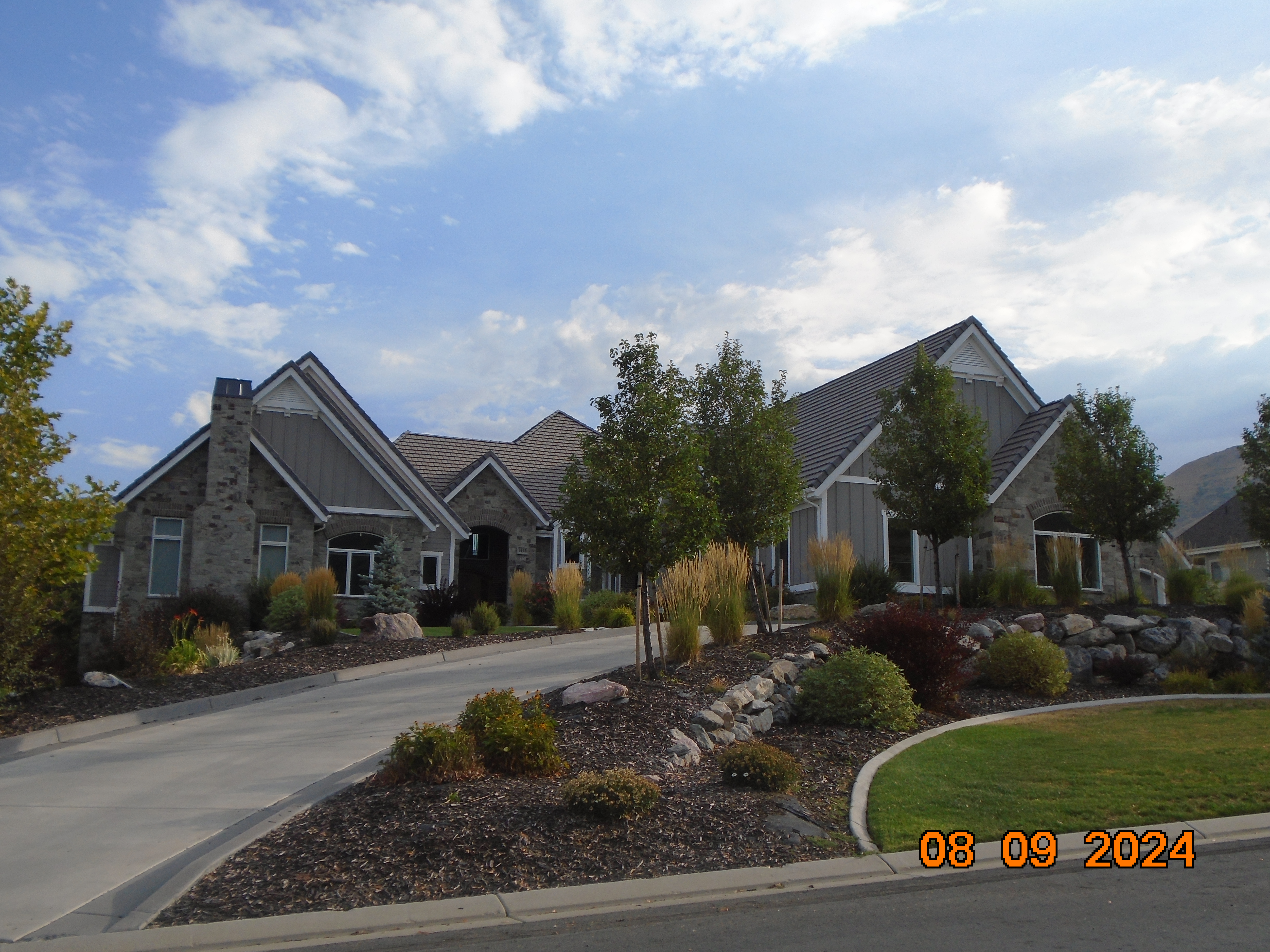
| Property Address: 1415 E 900 SOUTH - MAPLETON |
|
| Mailing Address: 1415 E 900 S MAPLETON, UT 84664 |
|
| Acreage: 1.044181 |
|
| Last Document:
33269-2020
|
|
| Subdivision Map Filing |
|
| Taxing Description:
LOT 2, NEMELKA LANE PHASE 1 SUB AREA 1.044 AC.
*Taxing description NOT FOR LEGAL DOCUMENTS
|
|
- Owner Names
- Value History
- Tax History
- Location
- Photos
- Documents
- Aerial Image
| |
----- Real Estate Values ----- |
---Improvements--- |
---Greenbelt--- |
Total |
| Year |
Com |
Res |
Agr |
Tot |
Com |
Res |
Agr |
Tot |
Land |
Homesite |
Tot |
Market Value |
| 2024 |
$0 |
$557,000 |
$4,800 |
$561,800 |
$0 |
$1,715,500 |
$0 |
$1,715,500 |
$0 |
$0 |
$0 |
$2,277,300 |
| 2023 |
$0 |
$557,000 |
$4,700 |
$561,700 |
$0 |
$1,707,300 |
$0 |
$1,707,300 |
$0 |
$0 |
$0 |
$2,269,000 |
| 2022 |
$0 |
$593,900 |
$5,000 |
$598,900 |
$0 |
$1,512,600 |
$0 |
$1,512,600 |
$0 |
$0 |
$0 |
$2,111,500 |
| 2021 |
$0 |
$321,000 |
$4,000 |
$325,000 |
$0 |
$1,163,500 |
$0 |
$1,163,500 |
$0 |
$0 |
$0 |
$1,488,500 |
| 2020 |
$0 |
$300,000 |
$3,500 |
$303,500 |
$0 |
$1,242,200 |
$0 |
$1,242,200 |
$0 |
$0 |
$0 |
$1,545,700 |
| 2019 |
$0 |
$280,000 |
$3,500 |
$283,500 |
$0 |
$0 |
$0 |
$0 |
$0 |
$0 |
$0 |
$283,500 |
| 2018 |
$0 |
$270,000 |
$2,900 |
$272,900 |
$0 |
$0 |
$0 |
$0 |
$0 |
$0 |
$0 |
$272,900 |
| 2017 |
$0 |
$240,000 |
$2,700 |
$242,700 |
$0 |
$0 |
$0 |
$0 |
$0 |
$0 |
$0 |
$242,700 |
| Year |
General Taxes |
Adjustments |
Net Taxes |
Fees |
Payments |
Tax Balance* |
Balance Due |
Tax District |
| 2025 |
$0.00 |
$0.00 |
$0.00 |
$0.00 |
|
$0.00
|
$0.00 |
140 - MAPLETON CITY |
| 2024 |
$12,807.72 |
$0.00 |
$12,807.72 |
$0.00 |
|
$0.00
|
$0.00 |
140 - MAPLETON CITY |
| 2023 |
$12,680.66 |
$0.00 |
$12,680.66 |
$0.00 |
|
$0.00
|
$0.00 |
140 - MAPLETON CITY |
| 2022 |
$11,937.12 |
$0.00 |
$11,937.12 |
$0.00 |
|
$0.00
|
$0.00 |
140 - MAPLETON CITY |
| 2021 |
$9,967.95 |
$0.00 |
$9,967.95 |
$0.00 |
|
$0.00
|
$0.00 |
140 - MAPLETON CITY |
| 2020 |
$10,697.48 |
$0.00 |
$10,697.48 |
$0.00 |
|
$0.00
|
$0.00 |
140 - MAPLETON CITY |
| 2019 |
$3,488.47 |
$0.00 |
$3,488.47 |
$0.00 |
|
$0.00
|
$0.00 |
140 - MAPLETON CITY |
| 2018 |
$3,527.51 |
$0.00 |
$3,527.51 |
$0.00 |
|
$0.00
|
$0.00 |
140 - MAPLETON CITY |
| 2017 |
$3,251.21 |
$0.00 |
$3,251.21 |
$0.00 |
|
$0.00
|
$0.00 |
140 - MAPLETON CITY |
* Note: Original tax amount (Does not include applicable interest and/or fees).
| Entry # |
Date |
Recorded |
Type |
Party1 (Grantor) |
Party2 (Grantee) |
| 33269-2020 |
03/11/2020 |
03/16/2020 |
WD |
GORDON, KEITH & DEBBIE |
FORBUSH, M DON TEE (ET AL) |
| 120080-2019 |
11/14/2019 |
11/15/2019 |
D TR |
GORDON, KEITH & DEBBIE |
CENTRAL BANK |
| 119330-2019 |
11/14/2019 |
11/14/2019 |
WD |
FORBUSH, M DON TEE (ET AL) |
GORDON, KEITH & DEBBIE |
| 118851-2019 |
11/13/2019 |
11/13/2019 |
WD |
FORBUSH, M DON TEE (ET AL) |
GORDON, KEITH & DEBBIE |
| 38849-2019 |
|
05/03/2019 |
P REC |
CENTRAL BANK TEE |
NEMELKA, INGRID F TEE (ET AL) |
| 65197-2018 |
07/12/2018 |
07/12/2018 |
WD |
NEMELKA, INGRID F TEE (ET AL) |
FORBUSH, M DON TEE (ET AL) |
| 2436-2017 |
12/28/2016 |
01/10/2017 |
REC |
CENTRAL BANK TEE |
NEMELKA, INGRID F & DAVID R TEE |
| 132220-2016 |
12/30/2016 |
12/30/2016 |
R FARM |
UTAH COUNTY TREASURER |
WHOM OF INTEREST |
| 132217-2016 |
12/30/2016 |
12/30/2016 |
R FARM |
UTAH COUNTY TREASURER |
BRAODBENT, JAY (ET AL) |
| 127747-2016 |
12/16/2016 |
12/20/2016 |
REC |
PRO-TITLE AND ESCROW INC TEE |
NEMELKA, INGRID F TEE |
| 127746-2016 |
12/13/2016 |
12/20/2016 |
SUB TEE |
AMA MANAGEMENT |
PRO-TITLE AND ESCROW INC SUCTEE |
| 125482-2016 |
12/13/2016 |
12/13/2016 |
W FARM |
NEMELKA, INGRID F (ET AL) (ET AL) |
WHOM OF INTEREST |
| 125403-2016 |
12/13/2016 |
12/13/2016 |
D TR |
NEMELKA, INGRID F TEE (ET AL) |
CENTRAL BANK |
| 123743-2016 |
07/20/2016 |
12/08/2016 |
S PLAT |
NEMELKA, INGRID F TEE (ET AL) |
NEMELKA LANE PHASE 1 |
Main Menu Comments or Concerns on Value/Appraisal - Assessor's Office
Documents/Owner/Parcel information - Recorder's Office
Address Change for Tax Notice
This page was created on 2/19/2025 3:50:55 PM |
