Property Information
mobile view
| Serial Number: 48:461:0127 |
Serial Life: 2017... |
|
|
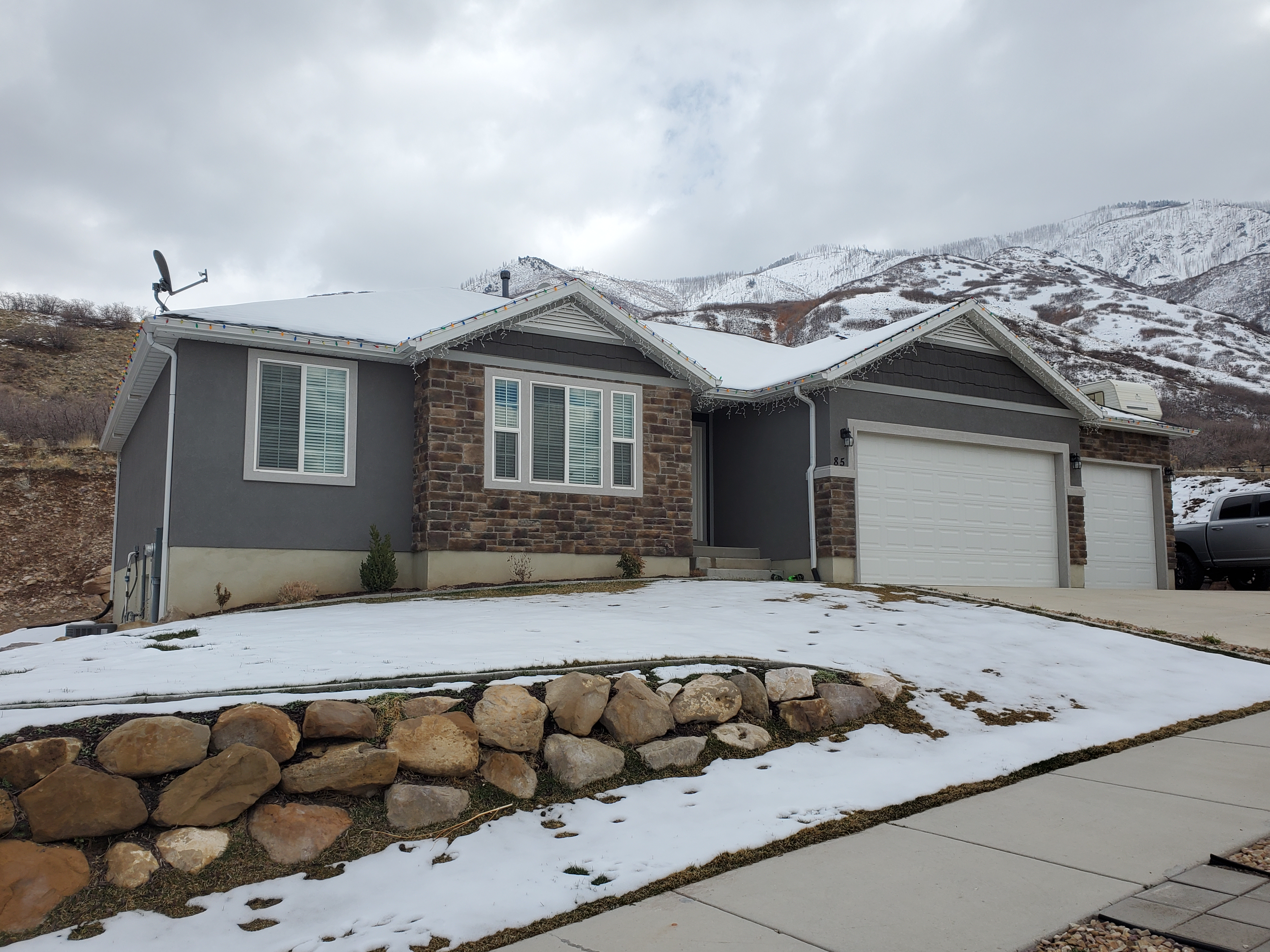 Total Photos: 3
|
| |
|
|
| Property Address: 85 S 1250 EAST - SANTAQUIN |
|
| Mailing Address: 85 S 1250 E SANTAQUIN, UT 84655 |
|
| Acreage: 0.242483 |
|
| Last Document:
8967-2020
|
|
| Subdivision Map Filing |
|
| Taxing Description:
LOT 127, PLAT G2, OAK SUMMIT PUD SUB AREA 0.242 AC.
*Taxing description NOT FOR LEGAL DOCUMENTS
|
|
- Owner Names
- Value History
- Tax History
- Location
- Photos
- Documents
- Aerial Image
| |
----- Real Estate Values ----- |
---Improvements--- |
---Greenbelt--- |
Total |
| Year |
Com |
Res |
Agr |
Tot |
Com |
Res |
Agr |
Tot |
Land |
Homesite |
Tot |
Market Value |
| 2024 |
$0 |
$174,200 |
$0 |
$174,200 |
$0 |
$353,800 |
$0 |
$353,800 |
$0 |
$0 |
$0 |
$528,000 |
| 2023 |
$0 |
$174,100 |
$0 |
$174,100 |
$0 |
$379,000 |
$0 |
$379,000 |
$0 |
$0 |
$0 |
$553,100 |
| 2022 |
$0 |
$185,600 |
$0 |
$185,600 |
$0 |
$362,100 |
$0 |
$362,100 |
$0 |
$0 |
$0 |
$547,700 |
| 2021 |
$0 |
$88,400 |
$0 |
$88,400 |
$0 |
$252,100 |
$0 |
$252,100 |
$0 |
$0 |
$0 |
$340,500 |
| 2020 |
$0 |
$76,900 |
$0 |
$76,900 |
$0 |
$240,100 |
$0 |
$240,100 |
$0 |
$0 |
$0 |
$317,000 |
| 2019 |
$0 |
$76,900 |
$0 |
$76,900 |
$0 |
$208,800 |
$0 |
$208,800 |
$0 |
$0 |
$0 |
$285,700 |
| 2018 |
$0 |
$73,200 |
$0 |
$73,200 |
$0 |
$195,900 |
$0 |
$195,900 |
$0 |
$0 |
$0 |
$269,100 |
| 2017 |
$0 |
$71,000 |
$0 |
$71,000 |
$0 |
$0 |
$0 |
$0 |
$0 |
$0 |
$0 |
$71,000 |
| Year |
General Taxes |
Adjustments |
Net Taxes |
Fees |
Payments |
Tax Balance* |
Balance Due |
Tax District |
| 2025 |
$0.00 |
$0.00 |
$0.00 |
$0.00 |
|
$0.00
|
$0.00 |
190 - SANTAQUIN CITY |
| 2024 |
$0.00 |
$0.00 |
$0.00 |
$0.00 |
|
$0.00
|
$0.00 |
190 - SANTAQUIN CITY |
| 2023 |
$3,045.09 |
$0.00 |
$3,045.09 |
$0.00 |
|
$0.00
|
$0.00 |
190 - SANTAQUIN CITY |
| 2022 |
$2,923.49 |
$0.00 |
$2,923.49 |
$0.00 |
|
$0.00
|
$0.00 |
190 - SANTAQUIN CITY |
| 2021 |
$2,131.75 |
$0.00 |
$2,131.75 |
$0.00 |
|
$0.00
|
$0.00 |
190 - SANTAQUIN CITY |
| 2020 |
$2,048.09 |
$0.00 |
$2,048.09 |
$0.00 |
|
$0.00
|
$0.00 |
190 - SANTAQUIN CITY |
| 2019 |
$1,805.01 |
$0.00 |
$1,805.01 |
$0.00 |
|
$0.00
|
$0.00 |
190 - SANTAQUIN CITY |
| 2018 |
$1,783.02 |
$0.00 |
$1,783.02 |
$0.00 |
|
$0.00
|
$0.00 |
190 - SANTAQUIN CITY |
| 2017 |
$880.47 |
$0.00 |
$880.47 |
$0.00 |
|
$0.00
|
$0.00 |
190 - SANTAQUIN CITY |
* Note: Original tax amount (Does not include applicable interest and/or fees).
| Entry # |
Date |
Recorded |
Type |
Party1 (Grantor) |
Party2 (Grantee) |
| 98440-2022 |
06/01/2022 |
09/07/2022 |
RC |
AMERICA FIRST FEDERAL CREDIT UNION |
WHOM OF INTEREST |
| 65333-2022 |
05/26/2022 |
05/31/2022 |
TR D |
PHILLIPS, TREVOR R & JESSICA |
AMERICA FIRST FEDERAL CREDIT UNION |
| 13956-2020 |
01/28/2020 |
02/03/2020 |
RSUBTEE |
MORTGAGE ELECTRONIC REGISTRATION SYSTEMS INC (ET AL) |
PHILLIPS, TREVOR R |
| 8967-2020 |
01/07/2020 |
01/23/2020 |
WD |
PHILLIPS, TREVOR R |
PHILLIPS, TREVOR R & JESSICA |
| 135534-2019 |
12/16/2019 |
12/20/2019 |
D TR |
PHILLIPS, TREVOR R |
UTAH COMMUNITY FEDERAL CREDIT UNION |
| 135533-2019 |
12/16/2019 |
12/20/2019 |
WD |
PHILLIPS, TREVOR R |
PHILLIPS, TREVOR R |
| 111954-2017 |
11/13/2017 |
11/13/2017 |
REC |
COTTONWOOD TITLE INSURANCE AGENCY INC TEE |
SALISBURY DEVELOPERS INC |
| 111953-2017 |
10/04/2017 |
11/13/2017 |
SUB TEE |
M & T BANK |
COTTONWOOD TITLE INSURANCE AGENCY INC SUCTEE |
| 78879-2017 |
08/11/2017 |
08/14/2017 |
D TR |
PHILLIPS, TREVOR R |
ACADEMY MORTGAGE CORPORATION |
| 78878-2017 |
08/04/2017 |
08/14/2017 |
WD |
SALISBURY DEVELOPERS INC |
PHILLIPS, TREVOR R |
| 48039-2017 |
01/18/2017 |
05/18/2017 |
REC |
GT TITLE SERVICES INC TEE |
SALISBURY DEVELOPERS INC |
| 48011-2017 |
03/27/2017 |
05/18/2017 |
P REC |
GT TITLE SERVICES INC TEE |
SALISBURY DEVELOPERS INC |
| 21532-2017 |
02/28/2017 |
03/03/2017 |
D TR |
SALISBURY DEVELOPERS INC |
M & T BANK |
| 60165-2016 |
06/28/2016 |
06/30/2016 |
S PLAT |
SALISBURY DEVELOPERS INC |
OAK SUMMIT PUD PLAT G2 |
Main Menu Comments or Concerns on Value/Appraisal - Assessor's Office
Documents/Owner/Parcel information - Recorder's Office
Address Change for Tax Notice
This page was created on 8/29/2024 5:12:29 AM |

