Property Information
mobile view
| Serial Number: 49:874:0056 |
Serial Life: 2018... |
|
|
 Total Photos: 3
|
| |
|
|
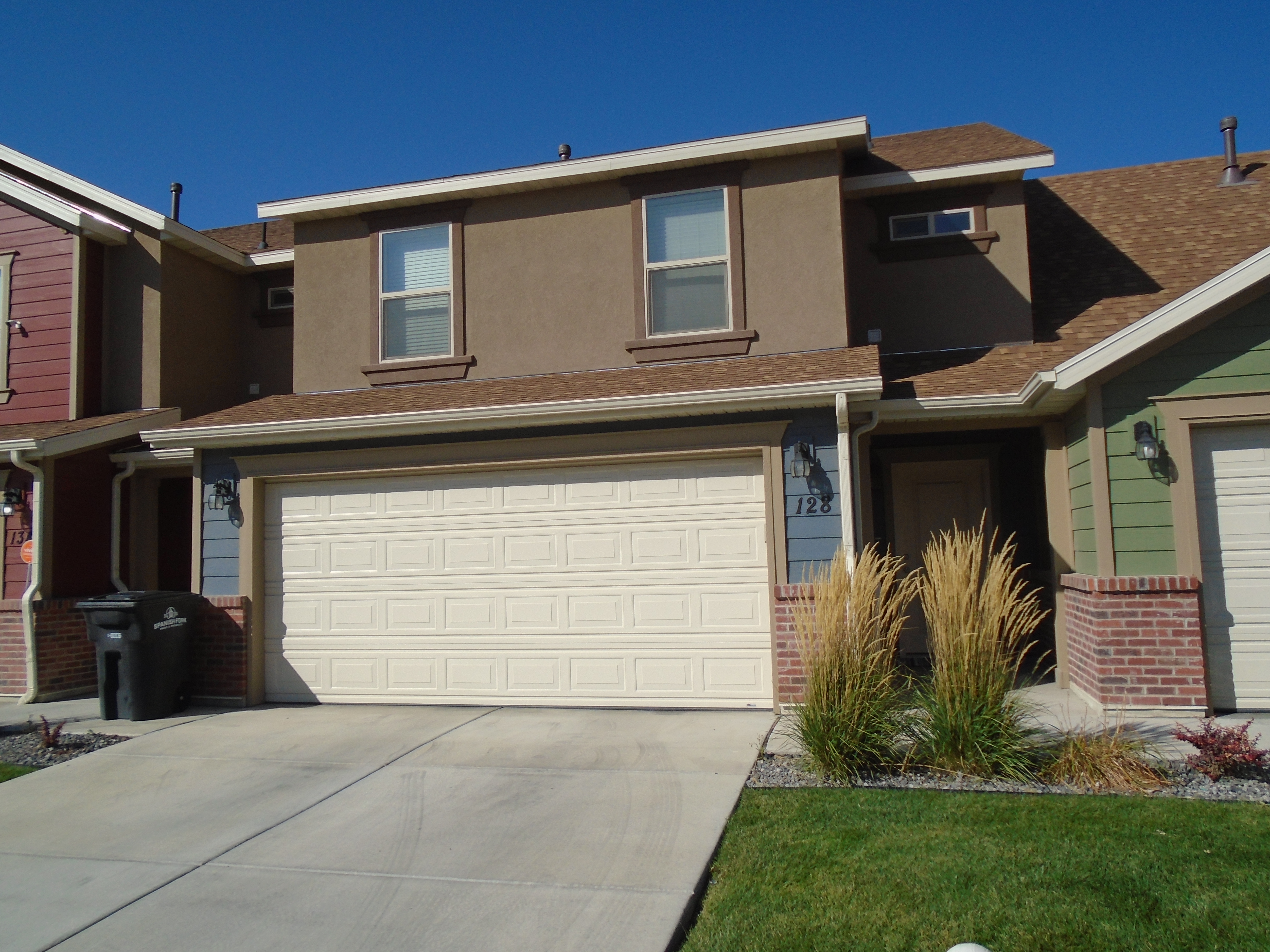
| Property Address: 128 W 700 SOUTH - SPANISH FORK |
|
| Mailing Address: 282 S 760 W OREM, UT 84058-5381 |
|
| Acreage: 0.025674 |
|
| Last Document:
53724-2018
|
|
| Subdivision Map Filing |
|
| Taxing Description:
LOT 56, PARKVIEW TOWNHOMES, PHASE 4 SUB AREA 0.026 AC.
*Taxing description NOT FOR LEGAL DOCUMENTS
|
|
- Owner Names
- Value History
- Tax History
- Location
- Photos
- Documents
- Aerial Image
| |
----- Real Estate Values ----- |
---Improvements--- |
---Greenbelt--- |
Total |
| Year |
Com |
Res |
Agr |
Tot |
Com |
Res |
Agr |
Tot |
Land |
Homesite |
Tot |
Market Value |
| 2024 |
$0 |
$53,000 |
$0 |
$53,000 |
$0 |
$307,600 |
$0 |
$307,600 |
$0 |
$0 |
$0 |
$360,600 |
| 2023 |
$0 |
$52,300 |
$0 |
$52,300 |
$0 |
$303,600 |
$0 |
$303,600 |
$0 |
$0 |
$0 |
$355,900 |
| 2022 |
$0 |
$55,600 |
$0 |
$55,600 |
$0 |
$314,900 |
$0 |
$314,900 |
$0 |
$0 |
$0 |
$370,500 |
| 2021 |
$0 |
$41,800 |
$0 |
$41,800 |
$0 |
$236,800 |
$0 |
$236,800 |
$0 |
$0 |
$0 |
$278,600 |
| 2020 |
$0 |
$40,200 |
$0 |
$40,200 |
$0 |
$219,800 |
$0 |
$219,800 |
$0 |
$0 |
$0 |
$260,000 |
| 2019 |
$0 |
$32,000 |
$0 |
$32,000 |
$0 |
$213,000 |
$0 |
$213,000 |
$0 |
$0 |
$0 |
$245,000 |
| 2018 |
$0 |
$21,000 |
$0 |
$21,000 |
$0 |
$0 |
$0 |
$0 |
$0 |
$0 |
$0 |
$21,000 |
| Year |
General Taxes |
Adjustments |
Net Taxes |
Fees |
Payments |
Tax Balance* |
Balance Due |
Tax District |
| 2025 |
$0.00 |
$0.00 |
$0.00 |
$0.00 |
|
$0.00
|
$0.00 |
150 - SPANISH FORK CITY |
| 2024 |
$0.00 |
$0.00 |
$0.00 |
$0.00 |
|
$0.00
|
$0.00 |
150 - SPANISH FORK CITY |
| 2023 |
$1,896.96 |
$0.00 |
$1,896.96 |
$0.00 |
|
$0.00
|
$0.00 |
150 - SPANISH FORK CITY |
| 2022 |
$2,013.50 |
$0.00 |
$2,013.50 |
$0.00 |
|
$0.00
|
$0.00 |
150 - SPANISH FORK CITY |
| 2021 |
$1,720.77 |
$0.00 |
$1,720.77 |
$0.00 |
|
$0.00
|
$0.00 |
150 - SPANISH FORK CITY |
| 2020 |
$1,651.79 |
$0.00 |
$1,651.79 |
$0.00 |
|
$0.00
|
$0.00 |
150 - SPANISH FORK CITY |
| 2019 |
$1,479.42 |
$0.00 |
$1,479.42 |
$0.00 |
|
$0.00
|
$0.00 |
150 - SPANISH FORK CITY |
| 2018 |
$238.52 |
$0.00 |
$238.52 |
$0.00 |
|
$0.00
|
$0.00 |
150 - SPANISH FORK CITY |
* Note: Original tax amount (Does not include applicable interest and/or fees).
| Entry # |
Date |
Recorded |
Type |
Party1 (Grantor) |
Party2 (Grantee) |
| 133656-2019 |
10/09/2019 |
12/17/2019 |
WATER D |
JJWH INVESTMENTS LLC |
STRAWBERRY WATER USER'S ASSOCIATION |
| 72776-2018 |
08/02/2018 |
08/02/2018 |
REC |
COTTONWOOD TITLE INSURANCE AGENCY INC TEE |
SALISBURY LAND DEVELOPMENT LLC |
| 62937-2018 |
06/26/2018 |
07/05/2018 |
REC |
COTTONWOOD TITLE INSURANCE AGENCY INC TEE |
SALISBURY DEVELOPERS INC |
| 53724-2018 |
06/08/2018 |
06/08/2018 |
WD |
HAIR, JOHN & JENNIFER |
JJWH INVESTMENTS LLC |
| 53703-2018 |
06/08/2018 |
06/08/2018 |
WD |
SALISBURY LAND DEVELOPMENT LLC |
HAIR, JOHN & JENNIFER |
| 42625-2018 |
04/23/2018 |
05/08/2018 |
REC |
COTTONWOOD TITLE INSURANCE AGENCY INC |
SALISBURY DEVELOPERS INC |
| 29089-2018 |
03/28/2018 |
03/28/2018 |
R LN |
FOUNDATION BUILDING MATERIALS LLC BY (ET AL) |
SALISBURY DEVELOPERS INC |
| 19786-2018 |
02/28/2018 |
02/28/2018 |
N LN |
SALISBURY DEVELOPERS INC |
FOUNDATION BUILDING MATERIALS LLC BY (ET AL) |
| 12385-2018 |
01/05/2018 |
02/07/2018 |
D TR |
SALISBURY LAND DEVELOPMENT LLC |
M & T BANK |
| 12384-2018 |
02/06/2018 |
02/07/2018 |
WD |
SALISBURY DEVELOPERS INC |
SALISBURY LAND DEVELOPMENT LLC |
| 111435-2017 |
04/19/2017 |
11/09/2017 |
S PLAT |
SALISBURY DEVELOPERS INC |
PARKVIEW TOWNHOMES PHASE 4 |
Main Menu Comments or Concerns on Value/Appraisal - Assessor's Office
Documents/Owner/Parcel information - Recorder's Office
Address Change for Tax Notice
This page was created on 8/30/2024 12:29:11 PM |

