Property Information
mobile view
| Serial Number: 51:518:0620 |
Serial Life: 2010... |
|
|
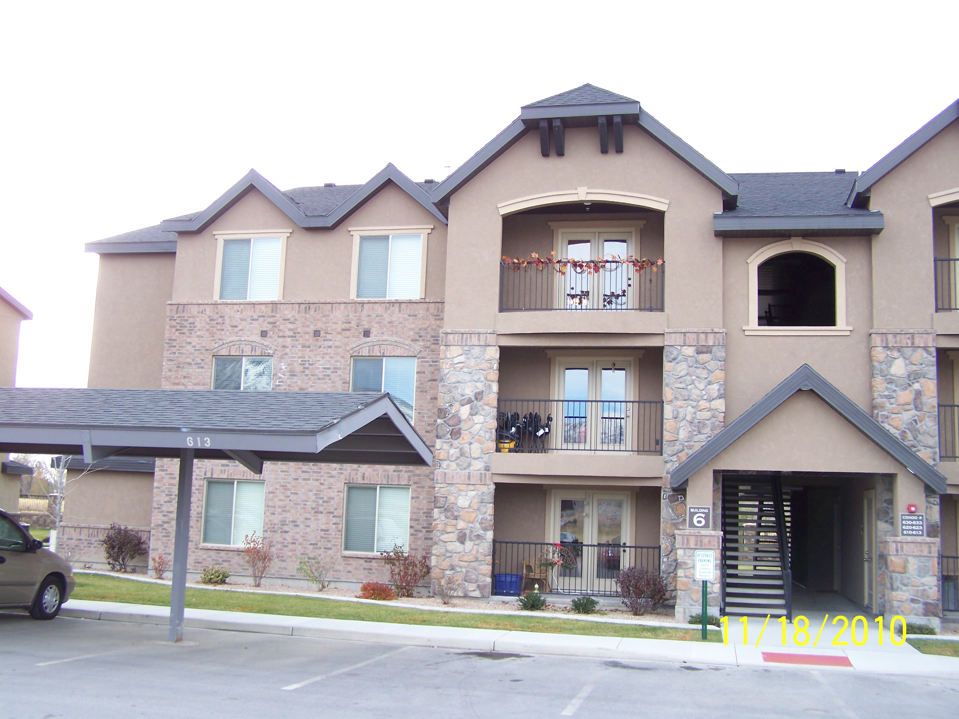 Total Photos: 1
|
| |
|
|
| Property Address: 1045 S 1700 WEST BLDG 6 Unit# 620 - PAYSON |
|
| Mailing Address: 1045 S 1700 W # 620 PAYSON, UT 84651-5528 |
|
| Acreage: 0.030057 |
|
| Last Document:
54363-2010
|
|
| Subdivision Map Filing |
|
| Taxing Description:
UNIT 620, BUILDING 6, PLAT C, RIDGESTONE CONDOMINIUMS. AREA 0.030 AC.
*Taxing description NOT FOR LEGAL DOCUMENTS
|
|
- Owner Names
- Value History
- Tax History
- Location
- Photos
- Documents
- Aerial Image
| |
----- Real Estate Values ----- |
---Improvements--- |
---Greenbelt--- |
Total |
| Year |
Com |
Res |
Agr |
Tot |
Com |
Res |
Agr |
Tot |
Land |
Homesite |
Tot |
Market Value |
| 2024 |
$0 |
$29,700 |
$0 |
$29,700 |
$0 |
$237,600 |
$0 |
$237,600 |
$0 |
$0 |
$0 |
$267,300 |
| 2023 |
$0 |
$28,600 |
$0 |
$28,600 |
$0 |
$228,700 |
$0 |
$228,700 |
$0 |
$0 |
$0 |
$257,300 |
| 2022 |
$0 |
$25,400 |
$0 |
$25,400 |
$0 |
$228,900 |
$0 |
$228,900 |
$0 |
$0 |
$0 |
$254,300 |
| 2021 |
$0 |
$22,400 |
$0 |
$22,400 |
$0 |
$164,600 |
$0 |
$164,600 |
$0 |
$0 |
$0 |
$187,000 |
| 2020 |
$0 |
$21,400 |
$0 |
$21,400 |
$0 |
$156,700 |
$0 |
$156,700 |
$0 |
$0 |
$0 |
$178,100 |
| 2019 |
$0 |
$20,000 |
$0 |
$20,000 |
$0 |
$149,600 |
$0 |
$149,600 |
$0 |
$0 |
$0 |
$169,600 |
| 2018 |
$0 |
$20,000 |
$0 |
$20,000 |
$0 |
$138,500 |
$0 |
$138,500 |
$0 |
$0 |
$0 |
$158,500 |
| 2017 |
$0 |
$16,000 |
$0 |
$16,000 |
$0 |
$121,000 |
$0 |
$121,000 |
$0 |
$0 |
$0 |
$137,000 |
| 2016 |
$0 |
$16,000 |
$0 |
$16,000 |
$0 |
$112,000 |
$0 |
$112,000 |
$0 |
$0 |
$0 |
$128,000 |
| 2015 |
$0 |
$15,000 |
$0 |
$15,000 |
$0 |
$109,000 |
$0 |
$109,000 |
$0 |
$0 |
$0 |
$124,000 |
| 2014 |
$0 |
$15,000 |
$0 |
$15,000 |
$0 |
$104,000 |
$0 |
$104,000 |
$0 |
$0 |
$0 |
$119,000 |
| 2013 |
$0 |
$15,000 |
$0 |
$15,000 |
$0 |
$104,000 |
$0 |
$104,000 |
$0 |
$0 |
$0 |
$119,000 |
| 2012 |
$0 |
$15,000 |
$0 |
$15,000 |
$0 |
$104,000 |
$0 |
$104,000 |
$0 |
$0 |
$0 |
$119,000 |
| 2011 |
$0 |
$15,000 |
$0 |
$15,000 |
$0 |
$105,000 |
$0 |
$105,000 |
$0 |
$0 |
$0 |
$120,000 |
| 2010 |
$0 |
$10,000 |
$0 |
$10,000 |
$0 |
$0 |
$0 |
$0 |
$0 |
$0 |
$0 |
$10,000 |
| Year |
General Taxes |
Adjustments |
Net Taxes |
Fees |
Payments |
Tax Balance* |
Balance Due |
Tax District |
| 2025 |
$0.00 |
$0.00 |
$0.00 |
$0.00 |
|
$0.00
|
$0.00 |
170 - PAYSON CITY |
| 2024 |
$1,444.57 |
$0.00 |
$1,444.57 |
$0.00 |
|
$0.00
|
$0.00 |
170 - PAYSON CITY |
| 2023 |
$1,386.71 |
$0.00 |
$1,386.71 |
$0.00 |
|
$0.00
|
$0.00 |
170 - PAYSON CITY |
| 2022 |
$1,393.47 |
$0.00 |
$1,393.47 |
$0.00 |
|
$0.00
|
$0.00 |
170 - PAYSON CITY |
| 2021 |
$1,161.59 |
$0.00 |
$1,161.59 |
$0.00 |
|
$0.00
|
$0.00 |
170 - PAYSON CITY |
| 2020 |
$1,130.79 |
$0.00 |
$1,130.79 |
$0.00 |
|
$0.00
|
$0.00 |
170 - PAYSON CITY |
| 2019 |
$1,050.33 |
$0.00 |
$1,050.33 |
$0.00 |
|
$0.00
|
$0.00 |
170 - PAYSON CITY |
| 2018 |
$1,018.47 |
$0.00 |
$1,018.47 |
$0.00 |
|
$0.00
|
$0.00 |
170 - PAYSON CITY |
| 2017 |
$900.21 |
$0.00 |
$900.21 |
$0.00 |
|
$0.00
|
$0.00 |
170 - PAYSON CITY |
| 2016 |
$846.63 |
$0.00 |
$846.63 |
$0.00 |
|
$0.00
|
$0.00 |
170 - PAYSON CITY |
| 2015 |
$825.83 |
$0.00 |
$825.83 |
$0.00 |
|
$0.00
|
$0.00 |
170 - PAYSON CITY |
| 2014 |
$786.84 |
$0.00 |
$786.84 |
$0.00 |
|
$0.00
|
$0.00 |
170 - PAYSON CITY |
| 2013 |
$823.62 |
$0.00 |
$823.62 |
$0.00 |
|
$0.00
|
$0.00 |
170 - PAYSON CITY |
| 2012 |
$836.06 |
$0.00 |
$836.06 |
$0.00 |
|
$0.00
|
$0.00 |
170 - PAYSON CITY |
| 2011 |
$823.09 |
$0.00 |
$823.09 |
$0.00 |
|
$0.00
|
$0.00 |
170 - PAYSON CITY |
| 2010 |
$121.60 |
$0.00 |
$121.60 |
$0.00 |
|
$0.00
|
$0.00 |
170 - PAYSON CITY |
* Note: Original tax amount (Does not include applicable interest and/or fees).
| Entry # |
Date |
Recorded |
Type |
Party1 (Grantor) |
Party2 (Grantee) |
| 83090-2024 |
11/25/2024 |
11/25/2024 |
COVLAND |
RIDGESTONE HOMEOWNERS ASSOCIATION INC BY ATY |
WHOM OF INTEREST |
| 82715-2024 |
11/01/2024 |
11/22/2024 |
ADECCON |
RIDGESTONE HOMEOWNERS ASSOCIATION INC |
WHOM OF INTEREST |
| 13162-2024 |
02/29/2024 |
03/01/2024 |
R LN |
RIDGESTONE HOMEOWNERS ASSOCIATION BY ATY |
RUSSELL, SPENCER |
| 72216-2023 |
11/01/2023 |
11/02/2023 |
ND |
JENKINS, BRUCE C TEE |
RUSSELL, SPENCER |
| 72203-2023 |
08/10/2023 |
11/02/2023 |
SUB TEE |
RIDGESTONE HOMEOWNERS ASSOCIATION |
JENKINS, BRUCE C TEE |
| 50304-2023 |
08/02/2023 |
08/02/2023 |
N LN |
RUSSELL, SPENCER |
RIDGESTONE HOMEOWNERS ASSOCIATION BY ATY |
| 13420-2022 |
01/26/2022 |
01/31/2022 |
REC |
CENTRAL BANK PAYSON TEE |
RIDGE STONE DEVELOPMENT LLC |
| 152266-2021 |
08/31/2021 |
09/01/2021 |
RSUBTEE |
MORTGAGE ELECTRONIC REGISTRATION SYSTEMS INC (ET AL) |
RUSSELL, SPENCER & SCOTT |
| 148192-2021 |
08/20/2021 |
08/25/2021 |
D TR |
RUSSELL, SPENCER |
EVERLEND MORTGAGE COMPANY |
| 148191-2021 |
08/20/2021 |
08/25/2021 |
SP WD |
RUSSELL, SPENCER & SCOTT |
RUSSELL, SPENCER |
| 27535-2018 |
03/07/2018 |
03/23/2018 |
ORDIN |
PAYSON CITY CORPORATION |
WHOM OF INTEREST |
| 2652-2018 |
11/27/2017 |
01/09/2018 |
REC |
RIVERS, ROD TEE |
BIGGS, THOMAS MATTHEW & AMBER M |
| 2651-2018 |
11/16/2017 |
01/09/2018 |
SUB TEE |
MORTGAGE ELECTRONIC REGISTRATION SYSTEMS INC |
RIVERS, ROD SUCTEE |
| 111294-2017 |
11/08/2017 |
11/08/2017 |
D TR |
RUSSELL, SPENCER & SCOTT |
SECURITYNATIONAL MORTGAGE COMPANY |
| 111243-2017 |
11/07/2017 |
11/08/2017 |
WD |
BIGGS, THOMAS MATTHEW & AMBER M |
RUSSELL, SPENCER & SCOTT |
| 61961-2016 |
07/06/2016 |
07/06/2016 |
REC |
WELLS FARGO FINANCIAL NATIONAL BANK TEE |
BIGGS, THOMAS MATTHEW & AMBER M |
| 61960-2016 |
07/06/2016 |
07/06/2016 |
SUB TEE |
MORTGAGE ELECTRONIC REGISTRATION SYSTEMS INC |
WELLS FARGO FINANCIAL NATIONAL BANK SUCTEE |
| 52808-2016 |
06/06/2016 |
06/10/2016 |
D TR |
BIGGS, THOMAS MATTHEW & AMBER M |
SECURITY HOME MORTGAGE LLC |
| 36689-2016 |
04/19/2016 |
04/27/2016 |
REC |
CENTRAL BANK COMPANY TEE |
RIDGE STONE DEVELOPMENT LLC |
| 104608-2015 |
11/06/2015 |
11/19/2015 |
REC |
CENTRAL BANK TEE |
RIDGE STONE DEVELOPMENT LLC (ET AL) |
| 38615-2015 |
03/03/2015 |
05/05/2015 |
ADD |
PAYSON CITY CORPORATION |
RIDGE STONE DEVELOPMENT LLC |
| 38614-2015 |
02/18/2015 |
05/05/2015 |
ADECCON |
RIDGE STONE DEVELOPMENT LLC |
WHOM OF INTEREST |
| 3187-2015 |
12/04/2014 |
01/14/2015 |
QCD |
UNITED STATES OF AMERICA |
SOUTH UTAH VALLEY ELECTRIC SERVICE DISTRICT |
| 85207-2013 |
03/13/2013 |
09/05/2013 |
WATERAG |
RIDGESTONE CONDOMINIUMS LLC |
STRAWBERRY WATER USERS ASSOCIATION (ET AL) |
| 71070-2013 |
07/10/2013 |
07/25/2013 |
ADECCON |
RIDGE STONE DEVELOPMENT LLC |
WHOM OF INTEREST |
| 60815-2012 |
06/27/2012 |
07/23/2012 |
ADECCON |
RIDGE STONE DEVELOPMENT LLC |
WHOM OF INTEREST |
| 54364-2010 |
06/25/2010 |
06/30/2010 |
D TR |
BIGGS, THOMAS MATTHEW & AMBER M |
SECURITY HOME MORTGAGE LLC |
| 54363-2010 |
06/24/2010 |
06/30/2010 |
WD |
RIDGESTONE DEVELOPMENT LLC |
BIGGS, THOMAS MATTHEW & AMBER M |
| 42009-2010 |
05/14/2010 |
05/21/2010 |
REC |
HESS, PAUL W TEE |
RIDGE STONE DEVELOPMENT LLC |
| 40541-2010 |
05/12/2010 |
05/17/2010 |
P REC |
CENTRAL BANK COMPANY TEE |
RIDGE STONE DEVELOPMENT LLC |
| 40540-2010 |
05/12/2010 |
05/17/2010 |
P REC |
CENTRAL BANK COMPANY TEE |
RIDGE STONE DEVELOPMENT LLC |
| 21539-2010 |
03/05/2010 |
03/17/2010 |
ADECCON |
RIDGESTONE CONDOS LLC |
WHOM OF INTEREST |
| 118929-2009 |
11/10/2009 |
11/16/2009 |
D TR |
RIDGE STONE DEVELOPMENT LLC |
CENTRAL BANK |
| 118786-2009 |
11/16/2009 |
11/16/2009 |
ADECCON |
RIDGE STONE DEVELOPMENT LLC |
WHOM OF INTEREST |
| 118785-2009 |
02/01/2006 |
11/16/2009 |
C PLAT |
REMKES, RYAN (ET AL) |
RIDGESTONE CONDOMINIUMS PLAT C |
Main Menu Comments or Concerns on Value/Appraisal - Assessor's Office
Documents/Owner/Parcel information - Recorder's Office
Address Change for Tax Notice
This page was created on 3/25/2025 6:11:32 PM |