Property Information
mobile view
| Serial Number: 52:030:0002 |
Serial Life: 1977... |
|
|
 Total Photos: 3
|
| |
|
|
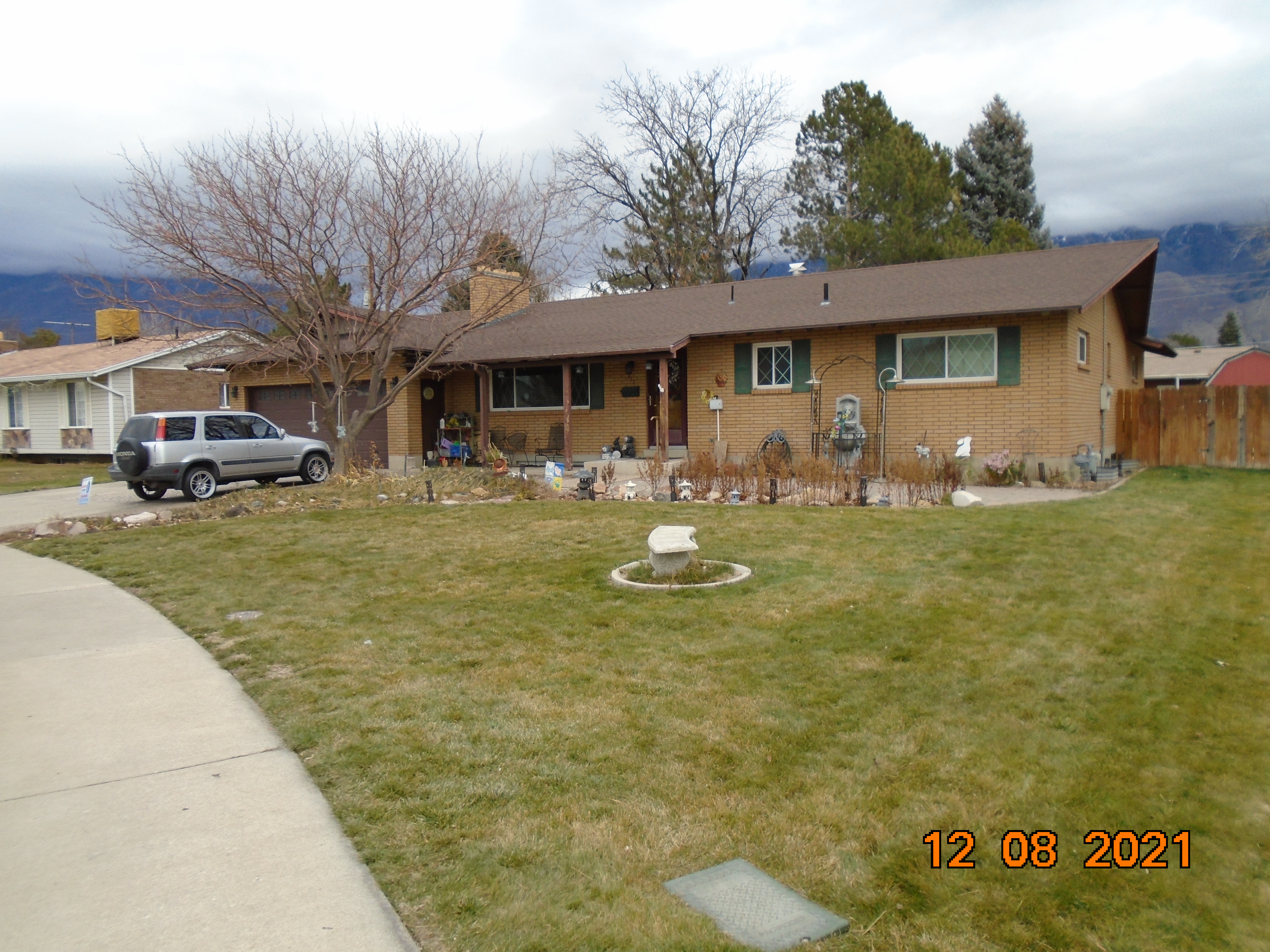
| Property Address: 351 S 300 EAST - OREM |
|
| Mailing Address: 351 S 300 E OREM, UT 84058-5504 |
|
| Acreage: 0.22 |
|
| Last Document:
19780-2004
|
|
| Subdivision Map Filing |
|
| Taxing Description:
LOT 2, PLAT A, SHERWOOD MEADOWS SUB AREA 0.209 AC.
*Taxing description NOT FOR LEGAL DOCUMENTS
|
|
- Owner Names
- Value History
- Tax History
- Location
- Photos
- Documents
- Aerial Image
| 2019... |
|
BARNEY, TOSHIKO |
|
| 2011-2018 |
|
BARNEY, MICHAEL D |
|
| 2011-2018 |
|
BARNEY, TOSHIKO |
|
| 2005-2010 |
|
BARNEY, MICHAEL D |
|
| 2005-2010 |
|
BARNEY, TOSHIKO |
|
| 2005NV |
|
SEARLE, ESTHER KNIGHT |
|
| 2005NV |
|
SEARLE, TEXAL ELIJAH |
|
| 1989-2004 |
|
SEARLE, ESTHER |
|
| 1989-2004 |
|
SEARLE, TEX E |
|
| 1983-1988 |
|
SEARLE, ESTHER |
|
| 1983-1988 |
|
SEARLE, TEX E |
|
| 1977-1982 |
|
SEARLE, ESTHER |
|
| 1977-1982 |
|
SEARLE, TEX E |
|
| |
----- Real Estate Values ----- |
---Improvements--- |
---Greenbelt--- |
Total |
| Year |
Com |
Res |
Agr |
Tot |
Com |
Res |
Agr |
Tot |
Land |
Homesite |
Tot |
Market Value |
| 2024 |
$0 |
$174,500 |
$0 |
$174,500 |
$0 |
$327,700 |
$0 |
$327,700 |
$0 |
$0 |
$0 |
$502,200 |
| 2023 |
$0 |
$174,500 |
$0 |
$174,500 |
$0 |
$320,600 |
$0 |
$320,600 |
$0 |
$0 |
$0 |
$495,100 |
| 2022 |
$0 |
$186,100 |
$0 |
$186,100 |
$0 |
$294,400 |
$0 |
$294,400 |
$0 |
$0 |
$0 |
$480,500 |
| 2021 |
$0 |
$132,900 |
$0 |
$132,900 |
$0 |
$243,300 |
$0 |
$243,300 |
$0 |
$0 |
$0 |
$376,200 |
| 2020 |
$0 |
$106,300 |
$0 |
$106,300 |
$0 |
$238,500 |
$0 |
$238,500 |
$0 |
$0 |
$0 |
$344,800 |
| 2019 |
$0 |
$99,200 |
$0 |
$99,200 |
$0 |
$208,700 |
$0 |
$208,700 |
$0 |
$0 |
$0 |
$307,900 |
| 2018 |
$0 |
$95,700 |
$0 |
$95,700 |
$0 |
$193,800 |
$0 |
$193,800 |
$0 |
$0 |
$0 |
$289,500 |
| 2017 |
$0 |
$88,600 |
$0 |
$88,600 |
$0 |
$184,500 |
$0 |
$184,500 |
$0 |
$0 |
$0 |
$273,100 |
| 2016 |
$0 |
$65,900 |
$0 |
$65,900 |
$0 |
$192,700 |
$0 |
$192,700 |
$0 |
$0 |
$0 |
$258,600 |
| 2015 |
$0 |
$65,900 |
$0 |
$65,900 |
$0 |
$181,400 |
$0 |
$181,400 |
$0 |
$0 |
$0 |
$247,300 |
| 2014 |
$0 |
$62,400 |
$0 |
$62,400 |
$0 |
$163,600 |
$0 |
$163,600 |
$0 |
$0 |
$0 |
$226,000 |
| 2013 |
$0 |
$46,900 |
$0 |
$46,900 |
$0 |
$142,300 |
$0 |
$142,300 |
$0 |
$0 |
$0 |
$189,200 |
| 2012 |
$0 |
$52,900 |
$0 |
$52,900 |
$0 |
$128,600 |
$0 |
$128,600 |
$0 |
$0 |
$0 |
$181,500 |
| 2011 |
$0 |
$58,500 |
$0 |
$58,500 |
$0 |
$128,600 |
$0 |
$128,600 |
$0 |
$0 |
$0 |
$187,100 |
| 2010 |
$0 |
$72,000 |
$0 |
$72,000 |
$0 |
$126,878 |
$0 |
$126,878 |
$0 |
$0 |
$0 |
$198,878 |
| 2009 |
$0 |
$72,000 |
$0 |
$72,000 |
$0 |
$135,200 |
$0 |
$135,200 |
$0 |
$0 |
$0 |
$207,200 |
| 2008 |
$0 |
$72,000 |
$0 |
$72,000 |
$0 |
$168,900 |
$0 |
$168,900 |
$0 |
$0 |
$0 |
$240,900 |
| 2007 |
$0 |
$75,000 |
$0 |
$75,000 |
$0 |
$175,900 |
$0 |
$175,900 |
$0 |
$0 |
$0 |
$250,900 |
| 2006 |
$0 |
$61,200 |
$0 |
$61,200 |
$0 |
$125,900 |
$0 |
$125,900 |
$0 |
$0 |
$0 |
$187,100 |
| 2005 |
$0 |
$58,249 |
$0 |
$58,249 |
$0 |
$119,920 |
$0 |
$119,920 |
$0 |
$0 |
$0 |
$178,169 |
| 2004 |
$0 |
$58,249 |
$0 |
$58,249 |
$0 |
$119,920 |
$0 |
$119,920 |
$0 |
$0 |
$0 |
$178,169 |
| 2003 |
$0 |
$58,249 |
$0 |
$58,249 |
$0 |
$119,920 |
$0 |
$119,920 |
$0 |
$0 |
$0 |
$178,169 |
| 2002 |
$0 |
$58,249 |
$0 |
$58,249 |
$0 |
$119,920 |
$0 |
$119,920 |
$0 |
$0 |
$0 |
$178,169 |
| 2001 |
$0 |
$58,249 |
$0 |
$58,249 |
$0 |
$119,920 |
$0 |
$119,920 |
$0 |
$0 |
$0 |
$178,169 |
| 2000 |
$0 |
$54,438 |
$0 |
$54,438 |
$0 |
$112,127 |
$0 |
$112,127 |
$0 |
$0 |
$0 |
$166,565 |
| 1999 |
$0 |
$50,877 |
$0 |
$50,877 |
$0 |
$104,792 |
$0 |
$104,792 |
$0 |
$0 |
$0 |
$155,669 |
| 1998 |
$0 |
$50,877 |
$0 |
$50,877 |
$0 |
$104,792 |
$0 |
$104,792 |
$0 |
$0 |
$0 |
$155,669 |
| 1997 |
$0 |
$50,877 |
$0 |
$50,877 |
$0 |
$104,792 |
$0 |
$104,792 |
$0 |
$0 |
$0 |
$155,669 |
| 1996 |
$0 |
$46,193 |
$0 |
$46,193 |
$0 |
$95,144 |
$0 |
$95,144 |
$0 |
$0 |
$0 |
$141,337 |
| 1995 |
$0 |
$41,994 |
$0 |
$41,994 |
$0 |
$95,144 |
$0 |
$95,144 |
$0 |
$0 |
$0 |
$137,138 |
| 1994 |
$0 |
$24,558 |
$0 |
$24,558 |
$0 |
$76,729 |
$0 |
$76,729 |
$0 |
$0 |
$0 |
$101,287 |
| 1993 |
$0 |
$24,558 |
$0 |
$24,558 |
$0 |
$76,729 |
$0 |
$76,729 |
$0 |
$0 |
$0 |
$101,287 |
| 1992 |
$0 |
$22,530 |
$0 |
$22,530 |
$0 |
$70,394 |
$0 |
$70,394 |
$0 |
$0 |
$0 |
$92,924 |
| 1991 |
$0 |
$19,763 |
$0 |
$19,763 |
$0 |
$54,031 |
$0 |
$54,031 |
$0 |
$0 |
$0 |
$73,794 |
| 1990 |
$0 |
$19,763 |
$0 |
$19,763 |
$0 |
$54,031 |
$0 |
$54,031 |
$0 |
$0 |
$0 |
$73,794 |
| 1989 |
$0 |
$19,763 |
$0 |
$19,763 |
$0 |
$54,031 |
$0 |
$54,031 |
$0 |
$0 |
$0 |
$73,794 |
| 1988 |
$0 |
$19,763 |
$0 |
$19,763 |
$0 |
$77,212 |
$0 |
$77,212 |
$0 |
$0 |
$0 |
$96,975 |
| 1987 |
$0 |
$20,375 |
$0 |
$20,375 |
$0 |
$79,600 |
$0 |
$79,600 |
$0 |
$0 |
$0 |
$99,975 |
| 1986 |
$0 |
$20,375 |
$0 |
$20,375 |
$0 |
$79,602 |
$0 |
$79,602 |
$0 |
$0 |
$0 |
$99,977 |
| 1985 |
$0 |
$20,375 |
$0 |
$20,375 |
$0 |
$79,600 |
$0 |
$79,600 |
$0 |
$0 |
$0 |
$99,975 |
| 1984 |
$0 |
$20,583 |
$0 |
$20,583 |
$0 |
$80,400 |
$0 |
$80,400 |
$0 |
$0 |
$0 |
$100,983 |
| Year |
General Taxes |
Adjustments |
Net Taxes |
Fees |
Payments |
Tax Balance* |
Balance Due |
Tax District |
| 2025 |
$0.00 |
$0.00 |
$0.00 |
$0.00 |
|
$0.00
|
$0.00 |
090 - OREM CITY |
| 2024 |
$2,258.85 |
$0.00 |
$2,258.85 |
$0.00 |
|
$0.00
|
$0.00 |
090 - OREM CITY |
| 2023 |
$2,071.97 |
$0.00 |
$2,071.97 |
$0.00 |
|
$0.00
|
$0.00 |
090 - OREM CITY |
| 2022 |
$2,075.62 |
$0.00 |
$2,075.62 |
$0.00 |
|
$0.00
|
$0.00 |
090 - OREM CITY |
| 2021 |
$1,950.75 |
$0.00 |
$1,950.75 |
$0.00 |
|
$0.00
|
$0.00 |
090 - OREM CITY |
| 2020 |
$1,819.22 |
$0.00 |
$1,819.22 |
$0.00 |
|
$0.00
|
$0.00 |
090 - OREM CITY |
| 2019 |
$1,562.21 |
$0.00 |
$1,562.21 |
$0.00 |
|
$0.00
|
$0.00 |
090 - OREM CITY |
| 2018 |
$1,537.32 |
$0.00 |
$1,537.32 |
$0.00 |
|
$0.00
|
$0.00 |
090 - OREM CITY |
| 2017 |
$1,488.98 |
$0.00 |
$1,488.98 |
$0.00 |
|
$0.00
|
$0.00 |
090 - OREM CITY |
| 2016 |
$1,528.97 |
$0.00 |
$1,528.97 |
$0.00 |
|
$0.00
|
$0.00 |
090 - OREM CITY |
| 2015 |
$1,546.08 |
$0.00 |
$1,546.08 |
$0.00 |
|
$0.00
|
$0.00 |
090 - OREM CITY |
| 2014 |
$1,419.38 |
$0.00 |
$1,419.38 |
$0.00 |
|
$0.00
|
$0.00 |
090 - OREM CITY |
| 2013 |
$1,281.39 |
$0.00 |
$1,281.39 |
$0.00 |
|
$0.00
|
$0.00 |
090 - OREM CITY |
| 2012 |
$1,254.60 |
$0.00 |
$1,254.60 |
$0.00 |
|
$0.00
|
$0.00 |
090 - OREM CITY |
| 2011 |
$1,287.14 |
$0.00 |
$1,287.14 |
$0.00 |
|
$0.00
|
$0.00 |
090 - OREM CITY |
| 2010 |
$1,280.87 |
$0.00 |
$1,280.87 |
$0.00 |
|
$0.00
|
$0.00 |
090 - OREM CITY |
| 2009 |
$1,237.04 |
$0.00 |
$1,237.04 |
$0.00 |
|
$0.00
|
$0.00 |
090 - OREM CITY |
| 2008 |
$1,332.77 |
$0.00 |
$1,332.77 |
$0.00 |
|
$0.00
|
$0.00 |
090 - OREM CITY |
| 2007 |
$1,372.22 |
$0.00 |
$1,372.22 |
$0.00 |
|
$0.00
|
$0.00 |
090 - OREM CITY |
| 2006 |
$1,089.66 |
$0.00 |
$1,089.66 |
$0.00 |
|
$0.00
|
$0.00 |
090 - OREM CITY |
| 2005 |
$1,171.21 |
$0.00 |
$1,171.21 |
$0.00 |
|
$0.00
|
$0.00 |
090 - OREM CITY |
| 2004 |
$1,150.44 |
$0.00 |
$1,150.44 |
$0.00 |
|
$0.00
|
$0.00 |
090 - OREM CITY |
| 2003 |
$1,116.34 |
$0.00 |
$1,116.34 |
$0.00 |
|
$0.00
|
$0.00 |
090 - OREM CITY |
| 2002 |
$1,020.21 |
$0.00 |
$1,020.21 |
$0.00 |
|
$0.00
|
$0.00 |
090 - OREM CITY |
| 2001 |
$1,010.41 |
$0.00 |
$1,010.41 |
$0.00 |
|
$0.00
|
$0.00 |
090 - OREM CITY |
| 2000 |
$976.66 |
$0.00 |
$976.66 |
$0.00 |
|
$0.00
|
$0.00 |
090 - OREM CITY |
| 1999 |
$939.74 |
$0.00 |
$939.74 |
$0.00 |
|
$0.00
|
$0.00 |
090 - OREM CITY |
| 1998 |
$887.34 |
$0.00 |
$887.34 |
$0.00 |
|
$0.00
|
$0.00 |
090 - OREM CITY |
| 1997 |
$883.66 |
$0.00 |
$883.66 |
$0.00 |
|
$0.00
|
$0.00 |
090 - OREM CITY |
| 1996 |
$732.96 |
$0.00 |
$732.96 |
$0.00 |
|
$0.00
|
$0.00 |
090 - OREM CITY |
| 1995 |
$804.80 |
$0.00 |
$804.80 |
$0.00 |
|
$0.00
|
$0.00 |
090 - OREM CITY |
| 1994 |
$947.03 |
$0.00 |
$947.03 |
$0.00 |
|
$0.00
|
$0.00 |
090 - OREM CITY |
| 1993 |
$838.13 |
$0.00 |
$838.13 |
$0.00 |
|
$0.00
|
$0.00 |
090 - OREM CITY |
| 1992 |
$775.25 |
$0.00 |
$775.25 |
$0.00 |
|
$0.00
|
$0.00 |
090 - OREM CITY |
| 1991 |
$643.67 |
$0.00 |
$643.67 |
$0.00 |
|
$0.00
|
$0.00 |
090 - OREM CITY |
| 1990 |
$618.77 |
$0.00 |
$618.77 |
$0.00 |
|
$0.00
|
$0.00 |
090 - OREM CITY |
| 1989 |
$630.64 |
$0.00 |
$630.64 |
$0.00 |
|
$0.00
|
$0.00 |
090 - OREM CITY |
| 1988 |
$826.75 |
$0.00 |
$826.75 |
$0.00 |
|
$0.00
|
$0.00 |
090 - OREM CITY |
| 1987 |
$838.23 |
$0.00 |
$838.23 |
$0.00 |
|
$0.00
|
$0.00 |
090 - OREM CITY |
| 1986 |
$826.95 |
$0.00 |
$826.95 |
$0.00 |
|
$0.00
|
$0.00 |
090 - OREM CITY |
| 1985 |
$831.87 |
$0.00 |
$831.87 |
$0.00 |
|
$0.00
|
$0.00 |
090 - OREM CITY |
| 1984 |
$824.15 |
$0.00 |
$824.15 |
$0.00 |
|
$0.00
|
$0.00 |
090 - OREM CITY |
* Note: Original tax amount (Does not include applicable interest and/or fees).
| Entry # |
Date |
Recorded |
Type |
Party1 (Grantor) |
Party2 (Grantee) |
| 97674-2018 |
07/20/2018 |
10/11/2018 |
D TR |
BARNEY, TOSHIKO |
ZB NA DBA (ET AL) |
| 97673-2018 |
07/20/2018 |
10/11/2018 |
AF DC |
BARNEY, MICHAEL DEAN & MICHAEL D AKA |
WHOM OF INTEREST |
| 102728-2008 |
09/15/2008 |
09/17/2008 |
REC |
HALLIDAY, PAUL M SUCTEE |
BARNEY, TOSHIKO & MICHAEL D |
| 102727-2008 |
08/25/2008 |
09/17/2008 |
SUB TEE |
MORTGAGE ELECTRONIC REGISTRATION SYSTEMS INC |
HALLIDAY, PAUL M SUCTEE |
| 2797-2008 |
12/21/2007 |
01/08/2008 |
REC |
ZIONS FIRST NATIONAL BANK TEE |
BARNEY, MICHAEL D & TOHIKO |
| 168857-2007 |
11/29/2007 |
12/04/2007 |
D TR |
BARNEY, TOSHIKO & MICHAEL D |
ZIONS FIRST NATIONAL BANK |
| 168856-2007 |
11/29/2007 |
12/04/2007 |
WD |
BARNEY, MICHAEL D & TOSHIKO |
BARNEY, TOSHIKO & MICHAEL D |
| 29586-2004 |
03/09/2004 |
03/16/2004 |
REC |
ZIONS FIRST NATIONAL BANK TEE |
BARNEY, MICHAEL D & TOSHIKO |
| 19782-2004 |
02/19/2004 |
02/23/2004 |
D TR |
BARNEY, MICHAEL D & TOSHIKO |
ZIONS FIRST NATIONAL BANK |
| 19781-2004 |
02/19/2004 |
02/23/2004 |
D TR |
BARNEY, MICHAEL D & TOSHIKO |
ZIONS FIRST NATIONAL BANK |
| 19780-2004 |
02/19/2004 |
02/23/2004 |
WD |
SEARLE, TEXAL ELIJAH & ESTHER KNIGHT TEE (ET AL) |
BARNEY, MICHAEL D & TOSHIKO |
| 4638-2004 |
01/12/2004 |
01/14/2004 |
SP WD |
SEARLE, TEX E & ESTHER |
SEARLE, TEXAL ELIJAH & ESTHER KNIGHT TEE |
| 71806-1996 |
08/27/1996 |
09/03/1996 |
SP IMPR |
OREM CITY OF |
WHOM OF INTEREST |
| 85418-1994 |
11/02/1994 |
11/07/1994 |
REC |
BANK ONE FKA (ET AL) |
SEARLE, TEXAL E & ESTHER K |
| 12727-1992 |
02/19/1992 |
03/19/1992 |
D TR |
SEARLE, TEXAL E & ESTHER K |
VALLEY BANK AND TRUST COMPANY |
| 9597-1985 |
04/09/1985 |
04/09/1985 |
REC |
SECURITY TITLE AND ABSTRACT COMPANY TEE |
SEARLE, TEX E & ESTHER |
| 28279-1984 |
07/27/1984 |
09/21/1984 |
AS |
FIRST SECURITY STATE BANK |
FIRST SECURITY BANK OF UTAH |
Main Menu Comments or Concerns on Value/Appraisal - Assessor's Office
Documents/Owner/Parcel information - Recorder's Office
Address Change for Tax Notice
This page was created on 3/9/2025 9:02:40 PM |

