Property Information
mobile view
| Serial Number: 55:817:0068 |
Serial Life: 2017... |
|
|
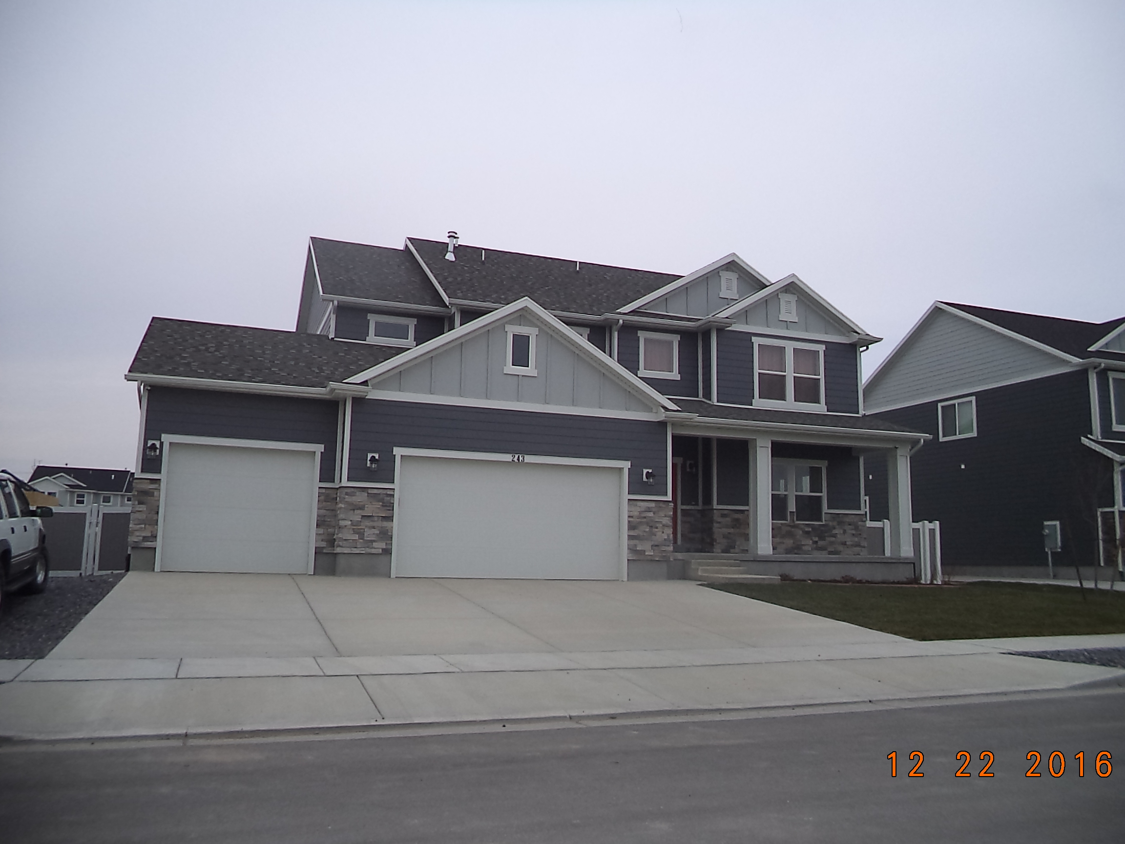
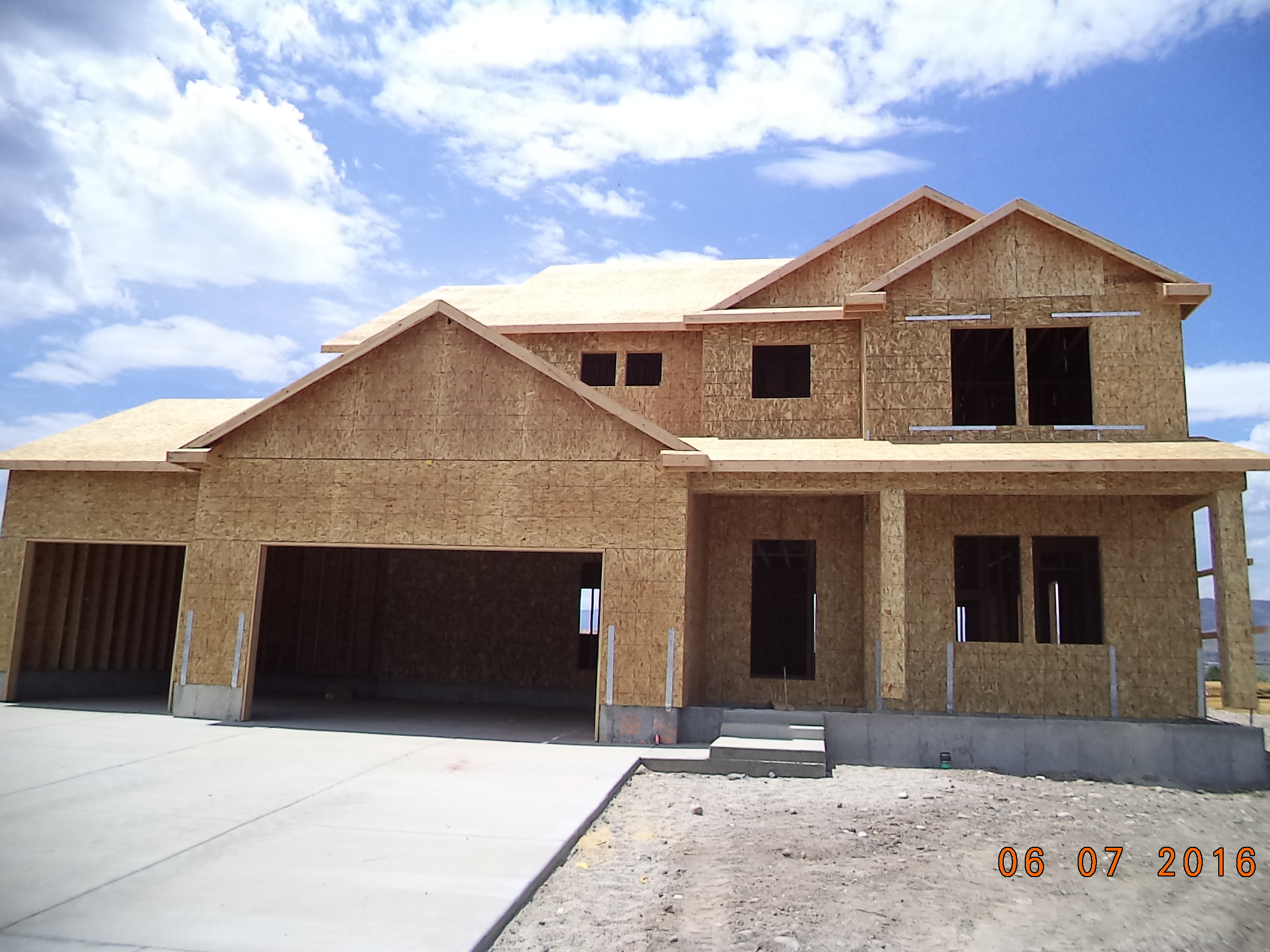
Total Photos: 2
|
| |
|
|
| Property Address: 243 N 2500 WEST - LEHI |
|
| Mailing Address: 243 N 2500 W LEHI, UT 84043 |
|
| Acreage: 0.219999 |
|
| Last Document:
21335-2016
|
|
| Subdivision Map Filing |
|
| Taxing Description:
LOT 68, PLAT C, WILLOW PARK RIVER SUB AREA 0.220 AC.
*Taxing description NOT FOR LEGAL DOCUMENTS
|
|
- Owner Names
- Value History
- Tax History
- Location
- Photos
- Documents
- Aerial Image
| |
----- Real Estate Values ----- |
---Improvements--- |
---Greenbelt--- |
Total |
| Year |
Com |
Res |
Agr |
Tot |
Com |
Res |
Agr |
Tot |
Land |
Homesite |
Tot |
Market Value |
| 2024 |
$0 |
$250,800 |
$0 |
$250,800 |
$0 |
$509,700 |
$0 |
$509,700 |
$0 |
$0 |
$0 |
$760,500 |
| 2023 |
$0 |
$243,500 |
$0 |
$243,500 |
$0 |
$530,400 |
$0 |
$530,400 |
$0 |
$0 |
$0 |
$773,900 |
| 2022 |
$0 |
$248,500 |
$0 |
$248,500 |
$0 |
$486,100 |
$0 |
$486,100 |
$0 |
$0 |
$0 |
$734,600 |
| 2021 |
$0 |
$155,300 |
$0 |
$155,300 |
$0 |
$396,200 |
$0 |
$396,200 |
$0 |
$0 |
$0 |
$551,500 |
| 2020 |
$0 |
$143,800 |
$0 |
$143,800 |
$0 |
$370,300 |
$0 |
$370,300 |
$0 |
$0 |
$0 |
$514,100 |
| 2019 |
$0 |
$143,800 |
$0 |
$143,800 |
$0 |
$322,000 |
$0 |
$322,000 |
$0 |
$0 |
$0 |
$465,800 |
| 2018 |
$0 |
$123,300 |
$0 |
$123,300 |
$0 |
$280,000 |
$0 |
$280,000 |
$0 |
$0 |
$0 |
$403,300 |
| 2017 |
$0 |
$116,400 |
$0 |
$116,400 |
$0 |
$244,700 |
$0 |
$244,700 |
$0 |
$0 |
$0 |
$361,100 |
| Year |
General Taxes |
Adjustments |
Net Taxes |
Fees |
Payments |
Tax Balance* |
Balance Due |
Tax District |
| 2025 |
$0.00 |
$0.00 |
$0.00 |
$0.00 |
|
$0.00
|
$0.00 |
010 - LEHI CITY |
| 2024 |
$0.00 |
$0.00 |
$0.00 |
$0.00 |
|
$0.00
|
$0.00 |
010 - LEHI CITY |
| 2023 |
$3,349.83 |
$0.00 |
$3,349.83 |
$0.00 |
|
$0.00
|
$0.00 |
010 - LEHI CITY |
| 2022 |
$3,279.92 |
$0.00 |
$3,279.92 |
$0.00 |
|
$0.00
|
$0.00 |
010 - LEHI CITY |
| 2021 |
$2,961.36 |
$0.00 |
$2,961.36 |
$0.00 |
|
$0.00
|
$0.00 |
010 - LEHI CITY |
| 2020 |
$2,792.77 |
$0.00 |
$2,792.77 |
$0.00 |
|
$0.00
|
$0.00 |
010 - LEHI CITY |
| 2019 |
$2,434.06 |
$0.00 |
$2,434.06 |
$0.00 |
|
$0.00
|
$0.00 |
010 - LEHI CITY |
| 2018 |
$2,229.24 |
$0.00 |
$2,229.24 |
$0.00 |
|
$0.00
|
$0.00 |
010 - LEHI CITY |
| 2017 |
$2,064.90 |
$0.00 |
$2,064.90 |
$0.00 |
|
$0.00
|
$0.00 |
010 - LEHI CITY |
* Note: Original tax amount (Does not include applicable interest and/or fees).
| Entry # |
Date |
Recorded |
Type |
Party1 (Grantor) |
Party2 (Grantee) |
| 86806-2016 |
09/07/2016 |
09/07/2016 |
RSUBTEE |
CENTRAL BANK (ET AL) |
WILLOW PARK DEVELOPMENT INC |
| 77895-2016 |
08/17/2016 |
08/17/2016 |
P REC |
ZB NA DBA (ET AL) |
FIELDSTONE UTAH INVESTORS LLC |
| 74461-2016 |
08/05/2016 |
08/08/2016 |
D TR |
LEABERRY, DANIEL H & LISA L |
CITYWIDE HOME LOANS |
| 71994-2016 |
08/01/2016 |
08/02/2016 |
D TR |
LEABERRY, DANIEL H & LISA L |
CITYWIDE HOME LOANS |
| 71993-2016 |
08/01/2016 |
08/02/2016 |
SP WD |
FIELDSTONE UTAH INVESTORS LLC |
LEABERRY, DANIEL H & LISA L |
| 44350-2016 |
05/06/2016 |
05/19/2016 |
TR D |
FIELDSTONE UTAH INVESTORS LLC |
ZB N A DBA (ET AL) |
| 39506-2016 |
05/04/2016 |
05/05/2016 |
WD |
FIELDSTONE UTAH INVESTORS LLC ATA (ET AL) |
FIELDSTONE UTAH INVESTORS LLC |
| 34157-2016 |
04/19/2016 |
04/20/2016 |
WD |
WILLOW PARK DEVELOPMENT INC |
FIELDSTONE UTAH INVESTORS LLC |
| 28180-2016 |
04/01/2016 |
04/01/2016 |
R FARM |
UTAH COUNTY TREASURER |
R W DAVIS LIVESTOCK (ET AL) |
| 21335-2016 |
05/12/2015 |
03/14/2016 |
S PLAT |
WILLOW PARK DEVELOPMENT INC |
WILLOW PARK RIVER PLAT C |
Main Menu Comments or Concerns on Value/Appraisal - Assessor's Office
Documents/Owner/Parcel information - Recorder's Office
Address Change for Tax Notice
This page was created on 7/5/2024 12:26:33 PM |