Property Information
mobile view
| Serial Number: 65:245:0004 |
Serial Life: 2008... |
|
|
Total Photos: 1
|
| |
|
|
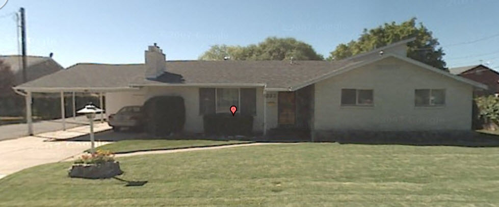
| Property Address: 293 N 1000 EAST - OREM |
|
| Mailing Address: 293 N 1000 E OREM, UT 84057 |
|
| Acreage: 0.522 |
|
| Last Document:
18564-2007
|
|
| Subdivision Map Filing |
|
| Taxing Description:
LOT 4, PLAT C, CANYON BREEZE SUBDV. AREA 0.522 AC.
*Taxing description NOT FOR LEGAL DOCUMENTS
|
|
- Owner Names
- Value History
- Tax History
- Location
- Photos
- Documents
- Aerial Image
| |
----- Real Estate Values ----- |
---Improvements--- |
---Greenbelt--- |
Total |
| Year |
Com |
Res |
Agr |
Tot |
Com |
Res |
Agr |
Tot |
Land |
Homesite |
Tot |
Market Value |
| 2024 |
$0 |
$293,700 |
$0 |
$293,700 |
$0 |
$304,700 |
$0 |
$304,700 |
$0 |
$0 |
$0 |
$598,400 |
| 2023 |
$0 |
$293,600 |
$0 |
$293,600 |
$0 |
$284,800 |
$0 |
$284,800 |
$0 |
$0 |
$0 |
$578,400 |
| 2022 |
$0 |
$313,000 |
$0 |
$313,000 |
$0 |
$242,700 |
$0 |
$242,700 |
$0 |
$0 |
$0 |
$555,700 |
| 2021 |
$0 |
$184,100 |
$0 |
$184,100 |
$0 |
$200,600 |
$0 |
$200,600 |
$0 |
$0 |
$0 |
$384,700 |
| 2020 |
$0 |
$147,300 |
$0 |
$147,300 |
$0 |
$196,700 |
$0 |
$196,700 |
$0 |
$0 |
$0 |
$344,000 |
| 2019 |
$0 |
$134,300 |
$0 |
$134,300 |
$0 |
$196,700 |
$0 |
$196,700 |
$0 |
$0 |
$0 |
$331,000 |
| 2018 |
$0 |
$130,000 |
$0 |
$130,000 |
$0 |
$175,300 |
$0 |
$175,300 |
$0 |
$0 |
$0 |
$305,300 |
| 2017 |
$0 |
$117,000 |
$0 |
$117,000 |
$0 |
$175,300 |
$0 |
$175,300 |
$0 |
$0 |
$0 |
$292,300 |
| 2016 |
$0 |
$86,700 |
$0 |
$86,700 |
$0 |
$152,400 |
$0 |
$152,400 |
$0 |
$0 |
$0 |
$239,100 |
| 2015 |
$0 |
$82,300 |
$0 |
$82,300 |
$0 |
$132,500 |
$0 |
$132,500 |
$0 |
$0 |
$0 |
$214,800 |
| 2014 |
$0 |
$78,000 |
$0 |
$78,000 |
$0 |
$110,400 |
$0 |
$110,400 |
$0 |
$0 |
$0 |
$188,400 |
| 2013 |
$0 |
$82,300 |
$0 |
$82,300 |
$0 |
$96,000 |
$0 |
$96,000 |
$0 |
$0 |
$0 |
$178,300 |
| 2012 |
$0 |
$101,900 |
$0 |
$101,900 |
$0 |
$110,400 |
$0 |
$110,400 |
$0 |
$0 |
$0 |
$212,300 |
| 2011 |
$0 |
$117,600 |
$0 |
$117,600 |
$0 |
$83,000 |
$0 |
$83,000 |
$0 |
$0 |
$0 |
$200,600 |
| 2010 |
$0 |
$97,586 |
$0 |
$97,586 |
$0 |
$115,660 |
$0 |
$115,660 |
$0 |
$0 |
$0 |
$213,246 |
| 2009 |
$0 |
$129,600 |
$0 |
$129,600 |
$0 |
$85,800 |
$0 |
$85,800 |
$0 |
$0 |
$0 |
$215,400 |
| 2008 |
$0 |
$129,600 |
$0 |
$129,600 |
$0 |
$139,600 |
$0 |
$139,600 |
$0 |
$0 |
$0 |
$269,200 |
| Year |
General Taxes |
Adjustments |
Net Taxes |
Fees |
Payments |
Tax Balance* |
Balance Due |
Tax District |
| 2025 |
$0.00 |
$0.00 |
$0.00 |
$0.00 |
|
$0.00
|
$0.00 |
090 - OREM CITY |
| 2024 |
$0.00 |
$0.00 |
$0.00 |
$0.00 |
|
$0.00
|
$0.00 |
090 - OREM CITY |
| 2023 |
$2,420.58 |
$0.00 |
$2,420.58 |
$0.00 |
|
$0.00
|
$0.00 |
090 - OREM CITY |
| 2022 |
$2,400.46 |
$0.00 |
$2,400.46 |
$0.00 |
|
$0.00
|
$0.00 |
090 - OREM CITY |
| 2021 |
$1,994.82 |
$0.00 |
$1,994.82 |
$0.00 |
|
$0.00
|
$0.00 |
090 - OREM CITY |
| 2020 |
$1,815.00 |
$0.00 |
$1,815.00 |
$0.00 |
|
$0.00
|
$0.00 |
090 - OREM CITY |
| 2019 |
$1,679.41 |
$0.00 |
$1,679.41 |
$0.00 |
|
$0.00
|
$0.00 |
090 - OREM CITY |
| 2018 |
$1,621.22 |
$0.00 |
$1,621.22 |
$0.00 |
|
$0.00
|
$0.00 |
090 - OREM CITY |
| 2017 |
$1,593.66 |
$0.00 |
$1,593.66 |
$0.00 |
|
$0.00
|
$0.00 |
090 - OREM CITY |
| 2016 |
$1,413.68 |
$0.00 |
$1,413.68 |
$0.00 |
|
$0.00
|
$0.00 |
090 - OREM CITY |
| 2015 |
$1,342.90 |
$0.00 |
$1,342.90 |
$0.00 |
|
$0.00
|
$0.00 |
090 - OREM CITY |
| 2014 |
$1,183.24 |
$0.00 |
$1,183.24 |
$0.00 |
|
$0.00
|
$0.00 |
090 - OREM CITY |
| 2013 |
$1,207.57 |
$0.00 |
$1,207.57 |
$0.00 |
|
$0.00
|
$0.00 |
090 - OREM CITY |
| 2012 |
$1,467.50 |
$0.00 |
$1,467.50 |
$0.00 |
|
$0.00
|
$0.00 |
090 - OREM CITY |
| 2011 |
$1,380.01 |
$0.00 |
$1,380.01 |
$0.00 |
|
$0.00
|
$0.00 |
090 - OREM CITY |
| 2010 |
$1,373.41 |
$0.00 |
$1,373.41 |
$0.00 |
|
$0.00
|
$0.00 |
090 - OREM CITY |
| 2009 |
$1,285.99 |
$0.00 |
$1,285.99 |
$0.00 |
|
$0.00
|
$0.00 |
090 - OREM CITY |
| 2008 |
$1,489.34 |
$0.00 |
$1,489.34 |
$0.00 |
|
$0.00
|
$0.00 |
090 - OREM CITY |
* Note: Original tax amount (Does not include applicable interest and/or fees).
| Entry # |
Date |
Recorded |
Type |
Party1 (Grantor) |
Party2 (Grantee) |
| 115627-2017 |
11/21/2017 |
11/21/2017 |
SP WD |
BENSON, R RALPH & LINDALIE A TEE (ET AL) |
BENSON, R RALPH & LINDALIE A TEE (ET AL) |
| 18564-2007 |
01/18/2007 |
02/06/2007 |
S PLAT |
BENSON, ROBERT RALPH & LINDALIE A (ET AL) |
CANYON BREEZE PLAT C |
Main Menu Comments or Concerns on Value/Appraisal - Assessor's Office
Documents/Owner/Parcel information - Recorder's Office
Address Change for Tax Notice
This page was created on 7/29/2024 3:29:57 AM |