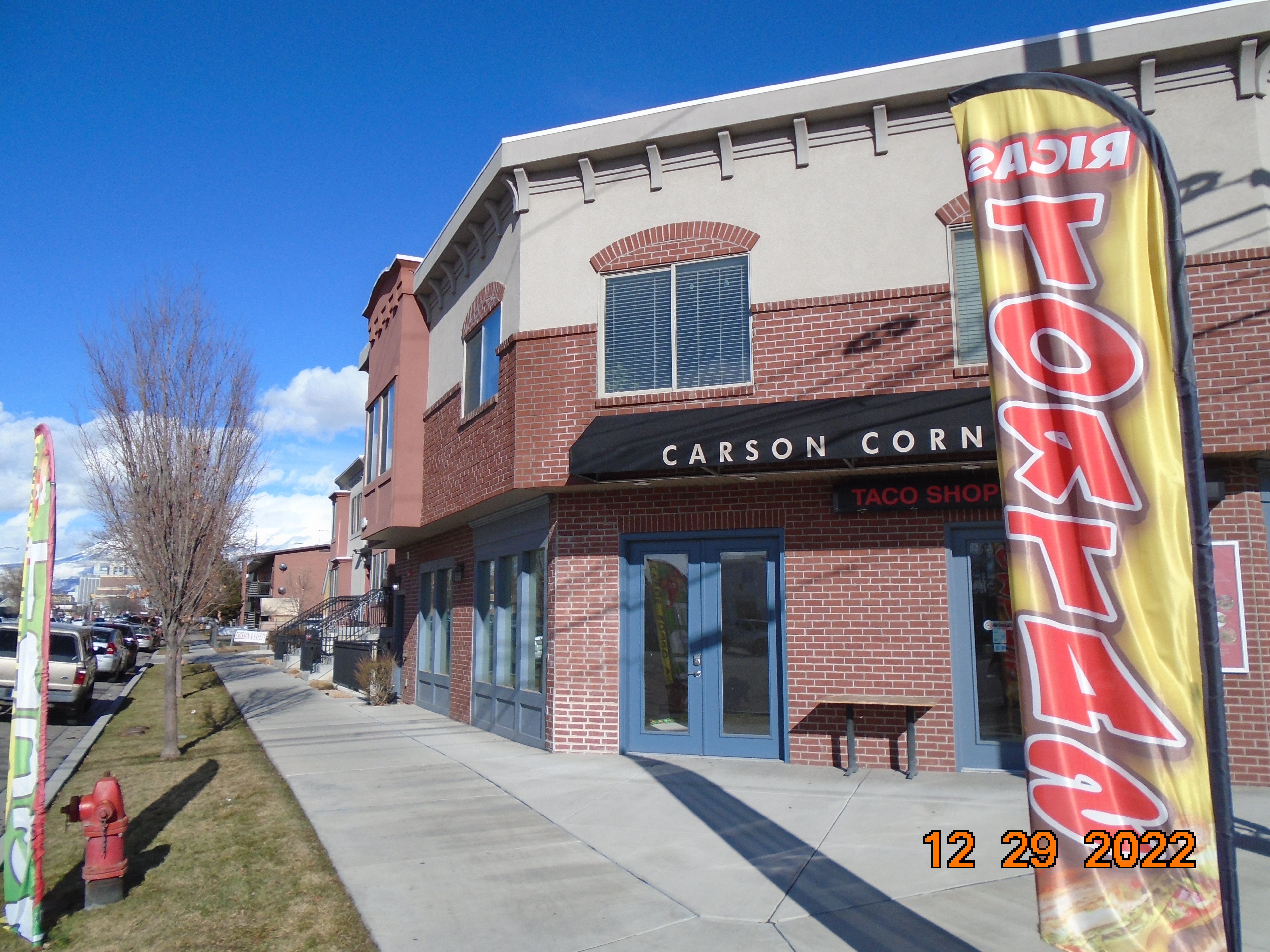
Property Information
mobile view
| Serial Number: 65:393:0005 |
Serial Life: 2014... |
|
|
 Total Photos: 11
|
| |
|
|
| Property Address: 491 S FREEDOM BLVD Unit# 105 205 - PROVO
more see "Addrs" tab below..
|
|
| Mailing Address: 2432 W VICTORIAN DR RIVERTON, UT 84065 |
|
| Acreage: 0.025715 |
|
| Last Document:
39328-2015
|
|
| Subdivision Map Filing |
|
| Taxing Description:
LOT 5, PLAT A, CARSON CORNER PUD. AREA 0.026 AC.
*Taxing description NOT FOR LEGAL DOCUMENTS
|
|
- Owner Names
- Value History
- Tax History
- Location
- Photos
- Documents
- Aerial Image
- Addrs
| |
----- Real Estate Values ----- |
---Improvements--- |
---Greenbelt--- |
Total |
| Year |
Com |
Res |
Agr |
Tot |
Com |
Res |
Agr |
Tot |
Land |
Homesite |
Tot |
Market Value |
| 2024 |
$14,200 |
$33,200 |
$0 |
$47,400 |
$164,900 |
$193,600 |
$0 |
$358,500 |
$0 |
$0 |
$0 |
$405,900 |
| 2023 |
$34,600 |
$43,400 |
$0 |
$78,000 |
$223,100 |
$280,100 |
$0 |
$503,200 |
$0 |
$0 |
$0 |
$581,200 |
| 2022 |
$34,609 |
$43,437 |
$0 |
$78,046 |
$138,289 |
$173,566 |
$0 |
$311,855 |
$0 |
$0 |
$0 |
$389,901 |
| 2021 |
$36,900 |
$35,100 |
$0 |
$72,000 |
$127,900 |
$100,500 |
$0 |
$228,400 |
$0 |
$0 |
$0 |
$300,400 |
| 2020 |
$36,900 |
$35,100 |
$0 |
$72,000 |
$127,900 |
$100,500 |
$0 |
$228,400 |
$0 |
$0 |
$0 |
$300,400 |
| 2019 |
$31,900 |
$31,900 |
$0 |
$63,800 |
$118,700 |
$93,300 |
$0 |
$212,000 |
$0 |
$0 |
$0 |
$275,800 |
| 2018 |
$31,900 |
$31,900 |
$0 |
$63,800 |
$118,700 |
$93,300 |
$0 |
$212,000 |
$0 |
$0 |
$0 |
$275,800 |
| 2017 |
$30,300 |
$28,900 |
$0 |
$59,200 |
$115,000 |
$90,400 |
$0 |
$205,400 |
$0 |
$0 |
$0 |
$264,600 |
| 2016 |
$28,900 |
$28,900 |
$0 |
$57,800 |
$90,900 |
$90,400 |
$0 |
$181,300 |
$0 |
$0 |
$0 |
$239,100 |
| 2015 |
$16,500 |
$16,900 |
$0 |
$33,400 |
$76,280 |
$76,100 |
$0 |
$152,380 |
$0 |
$0 |
$0 |
$185,780 |
| 2014 |
$0 |
$22,000 |
$0 |
$22,000 |
$0 |
$0 |
$0 |
$0 |
$0 |
$0 |
$0 |
$22,000 |
| Year |
General Taxes |
Adjustments |
Net Taxes |
Fees |
Payments |
Tax Balance* |
Balance Due |
Tax District |
| 2025 |
$0.00 |
$0.00 |
$0.00 |
$0.00 |
|
$0.00
|
$0.00 |
110 - PROVO CITY |
| 2024 |
$3,086.71 |
$0.00 |
$3,086.71 |
$0.00 |
|
$0.00
|
$0.00 |
110 - PROVO CITY |
| 2023 |
$4,489.12 |
$0.00 |
$4,489.12 |
$0.00 |
|
$0.00
|
$0.00 |
110 - PROVO CITY |
| 2022 |
$3,984.78 |
($998.00) |
$2,986.78 |
$0.00 |
|
$0.00
|
$0.00 |
110 - PROVO CITY |
| 2021 |
$2,550.35 |
$0.00 |
$2,550.35 |
$0.00 |
|
$0.00
|
$0.00 |
110 - PROVO CITY |
| 2020 |
$2,720.55 |
$0.00 |
$2,720.55 |
$0.00 |
|
$0.00
|
$0.00 |
110 - PROVO CITY |
| 2019 |
$2,398.26 |
$0.00 |
$2,398.26 |
$0.00 |
|
$0.00
|
$0.00 |
110 - PROVO CITY |
| 2018 |
$2,364.68 |
$0.00 |
$2,364.68 |
$0.00 |
|
$0.00
|
$0.00 |
110 - PROVO CITY |
| 2017 |
$2,274.72 |
$0.00 |
$2,274.72 |
$0.00 |
|
$0.00
|
$0.00 |
110 - PROVO CITY |
| 2016 |
$2,145.44 |
$0.00 |
$2,145.44 |
$0.00 |
|
$0.00
|
$0.00 |
110 - PROVO CITY |
| 2015 |
$1,883.77 |
($236.06) |
$1,647.71 |
$0.00 |
|
$0.00
|
$0.00 |
110 - PROVO CITY |
| 2014 |
$241.60 |
$0.00 |
$241.60 |
$0.00 |
|
$0.00
|
$0.00 |
110 - PROVO CITY |
* Note: Original tax amount (Does not include applicable interest and/or fees).
| Entry # |
Date |
Recorded |
Type |
Party1 (Grantor) |
Party2 (Grantee) |
| 63808-2021 |
03/31/2021 |
04/05/2021 |
REC |
UTAH COMMUNITY FEDERAL CREDIT UNION TEE |
ALG PROPERTIES LLC |
| 25624-2021 |
02/09/2021 |
02/10/2021 |
WD |
ALG CARSON CORNER 5 LLC |
MARINO, PATRICK A & LORI TEE (ET AL) |
| 182046-2020 |
11/13/2020 |
11/17/2020 |
WD |
ALG CARSON CORNER 4 LLC |
CLEGG, VEVA TEE (ET AL) |
| 5965-2019 |
01/18/2019 |
01/23/2019 |
SP WD |
ALG PROPERTIES LLC |
ALG CARSON CORNER 5 LLC |
| 39329-2015 |
05/06/2015 |
05/07/2015 |
D TR |
ALG PROPERTIES LLC |
UTAH COMMUNITY FEDERAL CREDIT UNION |
| 39328-2015 |
05/05/2015 |
05/07/2015 |
WD |
RNFH LLC |
ALG PROPERTIES LLC |
| 53145-2014 |
07/31/2014 |
07/31/2014 |
ADECCOV |
RNFH LLC |
WHOM OF INTEREST |
| 102823-2013 |
11/04/2013 |
11/05/2013 |
DECLCOV |
RNFH LLC |
WHOM OF INTEREST |
| 102820-2013 |
10/24/2013 |
11/05/2013 |
S PLAT |
RNFH LC |
CARSON CORNER PUD PLAT A |
491 S 200 WEST Unit# 105 205 - PROVO
491 S FREEDOM BLVD Unit# 105 205 - PROVO
Main Menu Comments or Concerns on Value/Appraisal - Assessor's Office
Documents/Owner/Parcel information - Recorder's Office
Address Change for Tax Notice
This page was created on 12/13/2024 2:49:06 AM |
