Property Information
mobile view
| Serial Number: 65:528:0015 |
Serial Life: 2018... |
|
|
 Total Photos: 9
|
| |
|
|
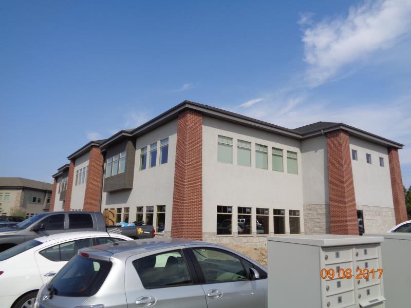
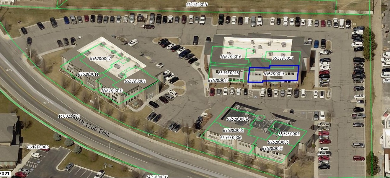
| Property Address: 240 N 1200 EAST Unit# 104 - LEHI |
|
| Mailing Address: %FLORENCE, TINA 110 BLUE RAVINE RD STE 209 FOLSOM, CA 95630 |
|
| Acreage: 0.057345 |
|
| Last Document:
110321-2017
|
|
| Subdivision Map Filing |
|
| Taxing Description:
UNIT 104, BUILDING 3, COOPER'S HOLLOW OFFICE AMENDED CONDOS. AREA 0.057 AC.
*Taxing description NOT FOR LEGAL DOCUMENTS
|
|
- Owner Names
- Value History
- Tax History
- Location
- Photos
- Documents
- Aerial Image
| |
----- Real Estate Values ----- |
---Improvements--- |
---Greenbelt--- |
Total |
| Year |
Com |
Res |
Agr |
Tot |
Com |
Res |
Agr |
Tot |
Land |
Homesite |
Tot |
Market Value |
| 2024 |
$92,300 |
$0 |
$0 |
$92,300 |
$686,400 |
$0 |
$0 |
$686,400 |
$0 |
$0 |
$0 |
$778,700 |
| 2023 |
$90,500 |
$0 |
$0 |
$90,500 |
$672,900 |
$0 |
$0 |
$672,900 |
$0 |
$0 |
$0 |
$763,400 |
| 2022 |
$90,500 |
$0 |
$0 |
$90,500 |
$550,800 |
$0 |
$0 |
$550,800 |
$0 |
$0 |
$0 |
$641,300 |
| 2021 |
$90,500 |
$0 |
$0 |
$90,500 |
$550,800 |
$0 |
$0 |
$550,800 |
$0 |
$0 |
$0 |
$641,300 |
| 2020 |
$90,500 |
$0 |
$0 |
$90,500 |
$550,800 |
$0 |
$0 |
$550,800 |
$0 |
$0 |
$0 |
$641,300 |
| 2019 |
$90,500 |
$0 |
$0 |
$90,500 |
$550,800 |
$0 |
$0 |
$550,800 |
$0 |
$0 |
$0 |
$641,300 |
| 2018 |
$90,500 |
$0 |
$0 |
$90,500 |
$535,500 |
$0 |
$0 |
$535,500 |
$0 |
$0 |
$0 |
$626,000 |
| Year |
General Taxes |
Adjustments |
Net Taxes |
Fees |
Payments |
Tax Balance* |
Balance Due |
Tax District |
| 2025 |
$0.00 |
$0.00 |
$0.00 |
$0.00 |
|
$0.00
|
$0.00 |
010 - LEHI CITY |
| 2024 |
$6,653.99 |
$0.00 |
$6,653.99 |
$0.00 |
|
$0.00
|
$0.00 |
010 - LEHI CITY |
| 2023 |
$6,007.96 |
$0.00 |
$6,007.96 |
$0.00 |
|
$0.00
|
$0.00 |
010 - LEHI CITY |
| 2022 |
$5,206.07 |
$0.00 |
$5,206.07 |
$0.00 |
|
$0.00
|
$0.00 |
010 - LEHI CITY |
| 2021 |
$6,261.01 |
$0.00 |
$6,261.01 |
$0.00 |
|
$0.00
|
$0.00 |
010 - LEHI CITY |
| 2020 |
$6,334.12 |
$0.00 |
$6,334.12 |
$0.00 |
|
$0.00
|
$0.00 |
010 - LEHI CITY |
| 2019 |
$6,092.99 |
$0.00 |
$6,092.99 |
$0.00 |
|
$0.00
|
$0.00 |
010 - LEHI CITY |
| 2018 |
$6,291.30 |
$0.00 |
$6,291.30 |
$0.00 |
|
$0.00
|
$0.00 |
010 - LEHI CITY |
* Note: Original tax amount (Does not include applicable interest and/or fees).
| Entry # |
Date |
Recorded |
Type |
Party1 (Grantor) |
Party2 (Grantee) |
| 120694-2017 |
12/06/2017 |
12/06/2017 |
REC |
ROCK CANYON BANK TEE |
COOPER HOLLOW OFFICE PARK II LLC |
| 110321-2017 |
10/17/2017 |
11/07/2017 |
WD |
COOPER'S HOLLOW OFFICE PARK II LLC |
MYRIAD CAPITAL LLC |
| 110194-2017 |
11/02/2017 |
11/06/2017 |
DECLCON |
COOPERS HOLLOW OFFICE PARK II LLC |
WHOM OF INTEREST |
| 110193-2017 |
07/11/2017 |
11/06/2017 |
C PLAT |
EXCEL PROPERTY INVESTMENTS LLC (ET AL) |
COOPER'S HOLLOW OFFICE CONDO AMENDED |
Main Menu Comments or Concerns on Value/Appraisal - Assessor's Office
Documents/Owner/Parcel information - Recorder's Office
Address Change for Tax Notice
This page was created on 3/4/2025 8:20:05 PM |