Property Information
mobile view
| Serial Number: 66:042:0004 |
Serial Life: 2013... |
|
|
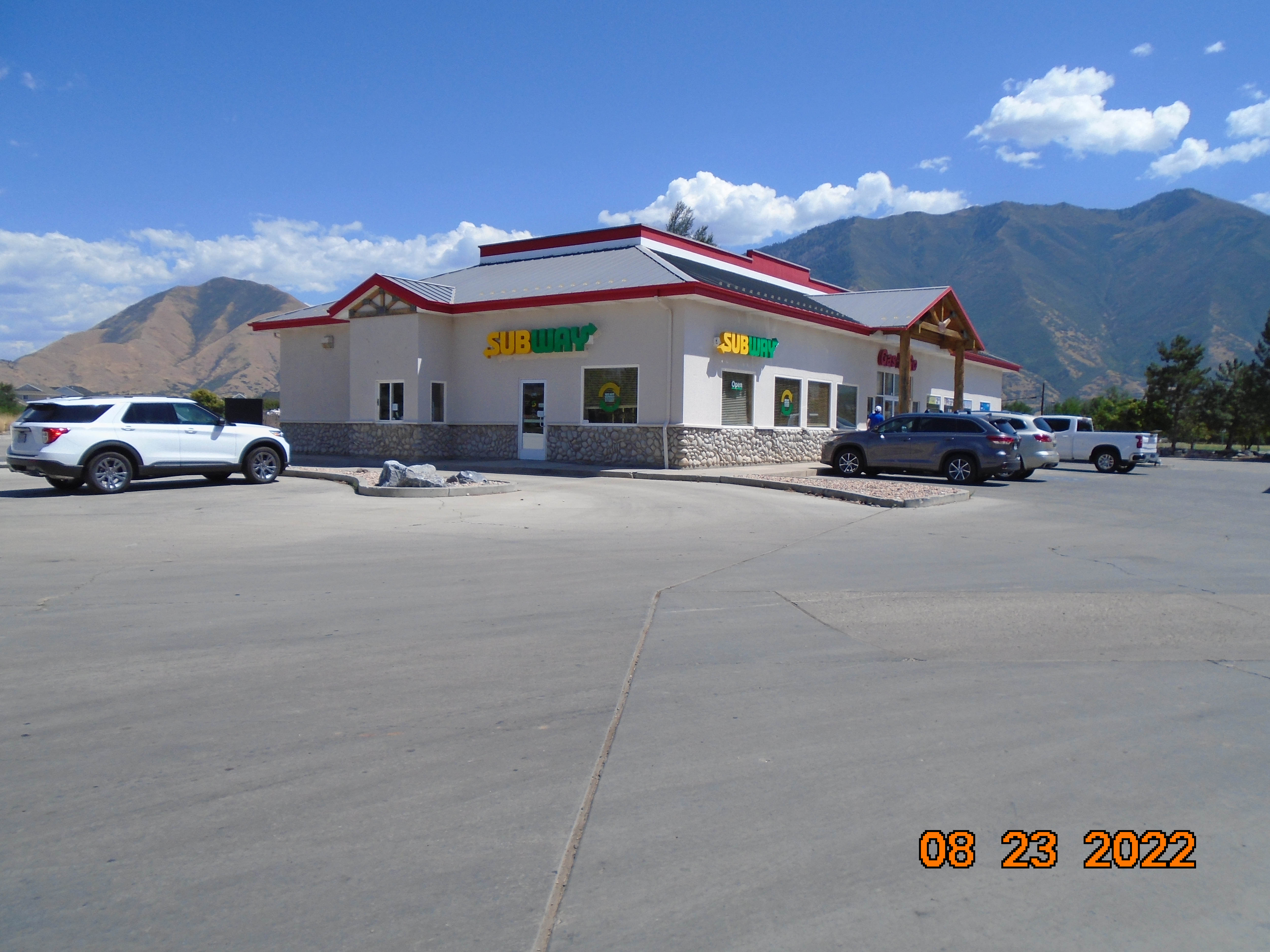
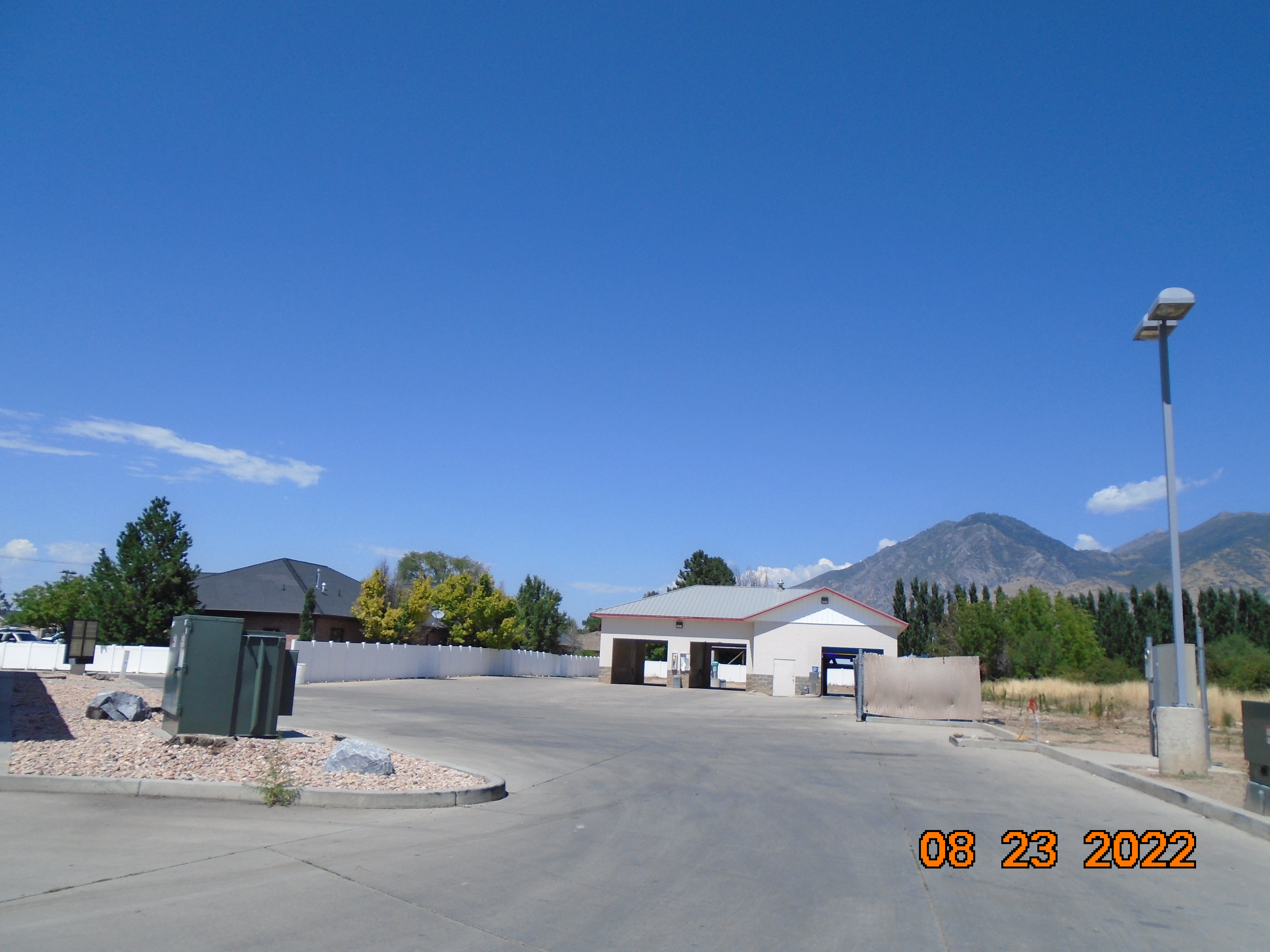
 Total Photos: 7
|
| |
|
|
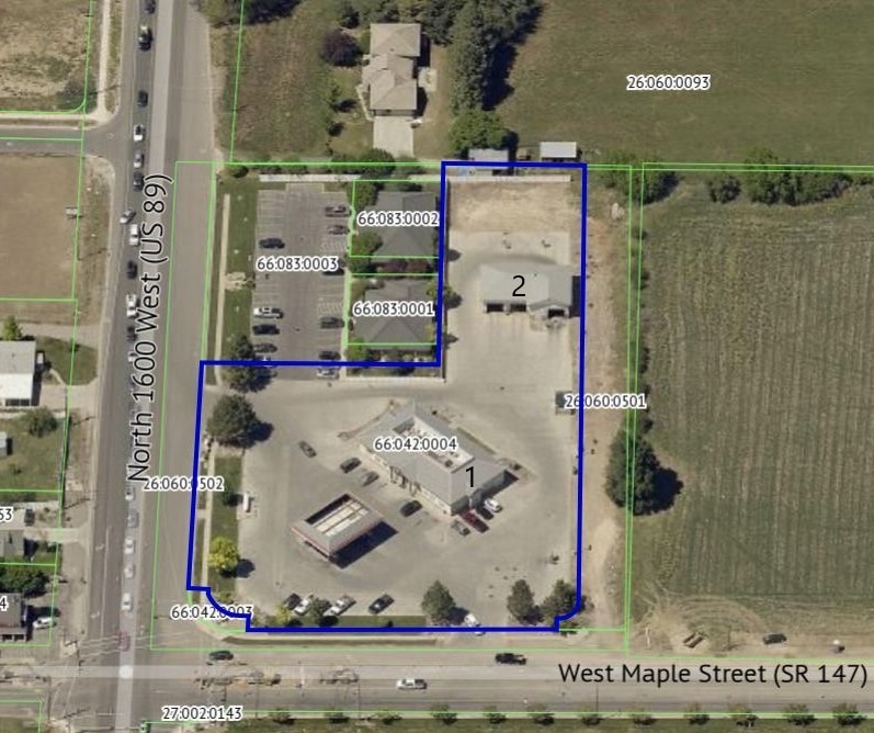
| Property Address: 48 N 1600 WEST - MAPLETON |
|
| Mailing Address: 705 SIERRA VIEW DR MAPLETON, UT 84664-5621 |
|
| Acreage: 2.176082 |
|
| Last Document:
45901-2012
|
|
| Subdivision Map Filing |
|
| Taxing Description:
PART LOT 1, PLAT A, STONEFIELD SUB DESCRIBED AS FOLLOWS; COM N 513.26 FT & E 186.1 FT FR SW COR. SEC. 10, T8S, R3E, SLB&M.; N 88 DEG 40' 2" E 101.94 FT; S 0 DEG 53' 1" E 463.49 FT; ALONG A CURVE TO R (CHORD BEARS: S 43 DEG 58' 46" W 21.16 FT, RADIUS = 14.99 FT); S 1 DEG 9' 33" E 11 FT; S 88 DEG 50' 40" W 214.43 FT; N 0 DEG 9' 3" W 14.82 FT; S 89 DEG 50' 59" W 5 FT; ALONG A CURVE TO R (CHORD BEARS: N 48 DEG 30' 46" W 32.09 FT, RADIUS = 27 FT); N 0 DEG 38' 55" E 5 FT; N 89 DEG 21' 10" W 14.12 FT; N 0 DEG 21' 24" W 234.19 FT; S 89 DEG 49' 48" E 167.88 FT; N 0 DEG 55' 13" W 216.74 FT TO BEG. AREA 2.176 AC.
*Taxing description NOT FOR LEGAL DOCUMENTS
|
|
- Owner Names
- Value History
- Tax History
- Location
- Photos
- Documents
- Aerial Image
| |
----- Real Estate Values ----- |
---Improvements--- |
---Greenbelt--- |
Total |
| Year |
Com |
Res |
Agr |
Tot |
Com |
Res |
Agr |
Tot |
Land |
Homesite |
Tot |
Market Value |
| 2024 |
$1,066,600 |
$0 |
$0 |
$1,066,600 |
$1,076,500 |
$0 |
$0 |
$1,076,500 |
$0 |
$0 |
$0 |
$2,143,100 |
| 2023 |
$804,200 |
$0 |
$0 |
$804,200 |
$1,000,900 |
$0 |
$0 |
$1,000,900 |
$0 |
$0 |
$0 |
$1,805,100 |
| 2022 |
$804,200 |
$0 |
$0 |
$804,200 |
$966,300 |
$0 |
$0 |
$966,300 |
$0 |
$0 |
$0 |
$1,770,500 |
| 2021 |
$775,900 |
$0 |
$0 |
$775,900 |
$713,000 |
$0 |
$0 |
$713,000 |
$0 |
$0 |
$0 |
$1,488,900 |
| 2020 |
$775,900 |
$0 |
$0 |
$775,900 |
$791,400 |
$0 |
$0 |
$791,400 |
$0 |
$0 |
$0 |
$1,567,300 |
| 2019 |
$646,600 |
$0 |
$0 |
$646,600 |
$808,100 |
$0 |
$0 |
$808,100 |
$0 |
$0 |
$0 |
$1,454,700 |
| 2018 |
$615,800 |
$0 |
$0 |
$615,800 |
$888,700 |
$0 |
$0 |
$888,700 |
$0 |
$0 |
$0 |
$1,504,500 |
| 2017 |
$614,200 |
$0 |
$0 |
$614,200 |
$824,900 |
$0 |
$0 |
$824,900 |
$0 |
$0 |
$0 |
$1,439,100 |
| 2016 |
$585,800 |
$0 |
$0 |
$585,800 |
$824,900 |
$0 |
$0 |
$824,900 |
$0 |
$0 |
$0 |
$1,410,700 |
| 2015 |
$456,900 |
$0 |
$0 |
$456,900 |
$824,900 |
$0 |
$0 |
$824,900 |
$0 |
$0 |
$0 |
$1,281,800 |
| 2014 |
$446,300 |
$0 |
$0 |
$446,300 |
$824,900 |
$0 |
$0 |
$824,900 |
$0 |
$0 |
$0 |
$1,271,200 |
| 2013 |
$425,000 |
$0 |
$0 |
$425,000 |
$824,900 |
$0 |
$0 |
$824,900 |
$0 |
$0 |
$0 |
$1,249,900 |
| Year |
General Taxes |
Adjustments |
Net Taxes |
Fees |
Payments |
Tax Balance* |
Balance Due |
Tax District |
| 2025 |
$0.00 |
$0.00 |
$0.00 |
$0.00 |
|
$0.00
|
$0.00 |
140 - MAPLETON CITY |
| 2024 |
$0.00 |
$0.00 |
$0.00 |
$0.00 |
|
$0.00
|
$0.00 |
140 - MAPLETON CITY |
| 2023 |
$18,310.93 |
$0.00 |
$18,310.93 |
$0.00 |
|
$0.00
|
$0.00 |
140 - MAPLETON CITY |
| 2022 |
$18,163.56 |
$0.00 |
$18,163.56 |
$0.00 |
|
$0.00
|
$0.00 |
140 - MAPLETON CITY |
| 2021 |
$18,088.65 |
$0.00 |
$18,088.65 |
$0.00 |
|
$0.00
|
$0.00 |
140 - MAPLETON CITY |
| 2020 |
$19,685.29 |
$0.00 |
$19,685.29 |
$0.00 |
|
$0.00
|
$0.00 |
140 - MAPLETON CITY |
| 2019 |
$17,900.08 |
$0.00 |
$17,900.08 |
$0.00 |
|
$0.00
|
$0.00 |
140 - MAPLETON CITY |
| 2018 |
$19,447.17 |
$0.00 |
$19,447.17 |
$0.00 |
|
$0.00
|
$0.00 |
140 - MAPLETON CITY |
| 2017 |
$19,278.18 |
$0.00 |
$19,278.18 |
$0.00 |
|
$0.00
|
$0.00 |
140 - MAPLETON CITY |
| 2016 |
$19,010.59 |
$0.00 |
$19,010.59 |
$0.00 |
|
$0.00
|
$0.00 |
140 - MAPLETON CITY |
| 2015 |
$17,378.64 |
$0.00 |
$17,378.64 |
$0.00 |
|
$0.00
|
$0.00 |
140 - MAPLETON CITY |
| 2014 |
$17,550.19 |
$0.00 |
$17,550.19 |
$0.00 |
|
$0.00
|
$0.00 |
140 - MAPLETON CITY |
| 2013 |
$18,369.78 |
$0.00 |
$18,369.78 |
$0.00 |
|
$0.00
|
$0.00 |
140 - MAPLETON CITY |
* Note: Original tax amount (Does not include applicable interest and/or fees).
| Entry # |
Date |
Recorded |
Type |
Party1 (Grantor) |
Party2 (Grantee) |
| 45901-2012 |
05/09/2012 |
06/04/2012 |
WD |
FRAMPTON, BRUCE T & CONNIE L TEE (ET AL) |
UTAH DEPARTMENT OF TRANSPORTATION |
Main Menu Comments or Concerns on Value/Appraisal - Assessor's Office
Documents/Owner/Parcel information - Recorder's Office
Address Change for Tax Notice
This page was created on 8/26/2024 7:38:41 PM |