Property Information
mobile view
| Serial Number: 66:224:0031 |
Serial Life: 2010-2014 |
|
|
 Total Photos: 2
|
| |
|
|
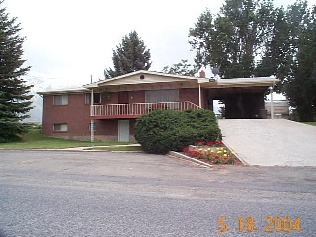
| Property Address: 1313 W 2000 NORTH - MAPLETON |
|
| Mailing Address: 711 N 800 E MAPLETON, UT 84664-5600 |
|
| Acreage: 0.679811 |
|
| Last Document:
83186-2009
|
|
| Subdivision Map Filing |
|
| Taxing Description:
LOT 21, PLAT A, SWEET IRON SUBDV. AREA 0.338 AC. ALSO COM N 1143.01 FT & E 1003.17 FT FR SW COR. SEC. 3, T8S, R3E, SLB&M.; N 89 DEG 1' 33" W 90.92 FT; N 1 DEG 14' 0" W 163.6 FT; S 89 DEG 23' 0" E 90.9 FT; S 1 DEG 14' 0" E 164.17 FT TO BEG. AREA 0.342 AC. TOTAL AREA .68 AC.
*Taxing description NOT FOR LEGAL DOCUMENTS
|
|
- Owner Names
- Value History
- Tax History
- Location
- Photos
- Documents
- Aerial Image
| |
----- Real Estate Values ----- |
---Improvements--- |
---Greenbelt--- |
Total |
| Year |
Com |
Res |
Agr |
Tot |
Com |
Res |
Agr |
Tot |
Land |
Homesite |
Tot |
Market Value |
| 2014 |
$0 |
$106,900 |
$0 |
$106,900 |
$0 |
$92,100 |
$0 |
$92,100 |
$0 |
$0 |
$0 |
$199,000 |
| 2013 |
$0 |
$91,000 |
$0 |
$91,000 |
$0 |
$87,200 |
$0 |
$87,200 |
$0 |
$0 |
$0 |
$178,200 |
| 2012 |
$0 |
$97,900 |
$0 |
$97,900 |
$0 |
$77,900 |
$0 |
$77,900 |
$0 |
$0 |
$0 |
$175,800 |
| 2011 |
$0 |
$84,900 |
$0 |
$84,900 |
$0 |
$97,200 |
$0 |
$97,200 |
$0 |
$0 |
$0 |
$182,100 |
| 2010 |
$0 |
$90,450 |
$0 |
$90,450 |
$0 |
$103,141 |
$0 |
$103,141 |
$0 |
$0 |
$0 |
$193,591 |
| Year |
General Taxes |
Adjustments |
Net Taxes |
Fees |
Payments |
Tax Balance* |
Balance Due |
Tax District |
| 2014 |
$1,511.07 |
$0.00 |
$1,511.07 |
$0.00 |
|
$0.00
|
$0.00 |
140 - MAPLETON CITY |
| 2013 |
$1,440.45 |
($919.80) |
$520.65 |
$0.00 |
|
$0.00
|
$0.00 |
140 - MAPLETON CITY |
| 2012 |
$1,453.54 |
($914.56) |
$538.98 |
$0.00 |
|
$0.00
|
$0.00 |
140 - MAPLETON CITY |
| 2011 |
$1,474.08 |
($913.03) |
$561.05 |
$0.00 |
|
$0.00
|
$0.00 |
140 - MAPLETON CITY |
| 2010 |
$1,523.03 |
($1,523.03) |
$0.00 |
$0.00 |
|
$0.00
|
$0.00 |
140 - MAPLETON CITY |
* Note: Original tax amount (Does not include applicable interest and/or fees).
| Entry # |
Date |
Recorded |
Type |
Party1 (Grantor) |
Party2 (Grantee) |
| 31030-2014 |
05/08/2014 |
05/08/2014 |
WD W |
SNYDER, RUSSELL KAY & RONLAD FRANK TEE (ET AL) |
JESSOP, SAMUEL P |
| 31029-2014 |
05/08/2014 |
05/08/2014 |
AF DC |
SNYDER, RENEE AVERETT & RENEE A AKA |
SNYDER, RANDY KENT & RUSSELL KAY SUCTEE (ET AL) |
| 13455-2012 |
06/17/2011 |
02/21/2012 |
REC |
PRO-TITLE AND ESCROW INC TEE |
SWEET IRON DEVELOPMENT LLC |
| 46113-2011 |
06/22/2011 |
06/24/2011 |
REC |
FAR WEST BANK DIV OF (ET AL) |
SWEET IRON DEVELOPMENT LLC |
| 83186-2009 |
07/30/2009 |
07/30/2009 |
N SPREC |
UTAH COUNTY RECORDER |
WHOM OF INTEREST |
Main Menu Comments or Concerns on Value/Appraisal - Assessor's Office
Documents/Owner/Parcel information - Recorder's Office
Address Change for Tax Notice
This page was created on 9/3/2024 1:26:47 PM |
