Property Information
mobile view
| Serial Number: 67:034:0009 |
Serial Life: 2019... |
|
|
 Total Photos: 3
|
| |
|
|
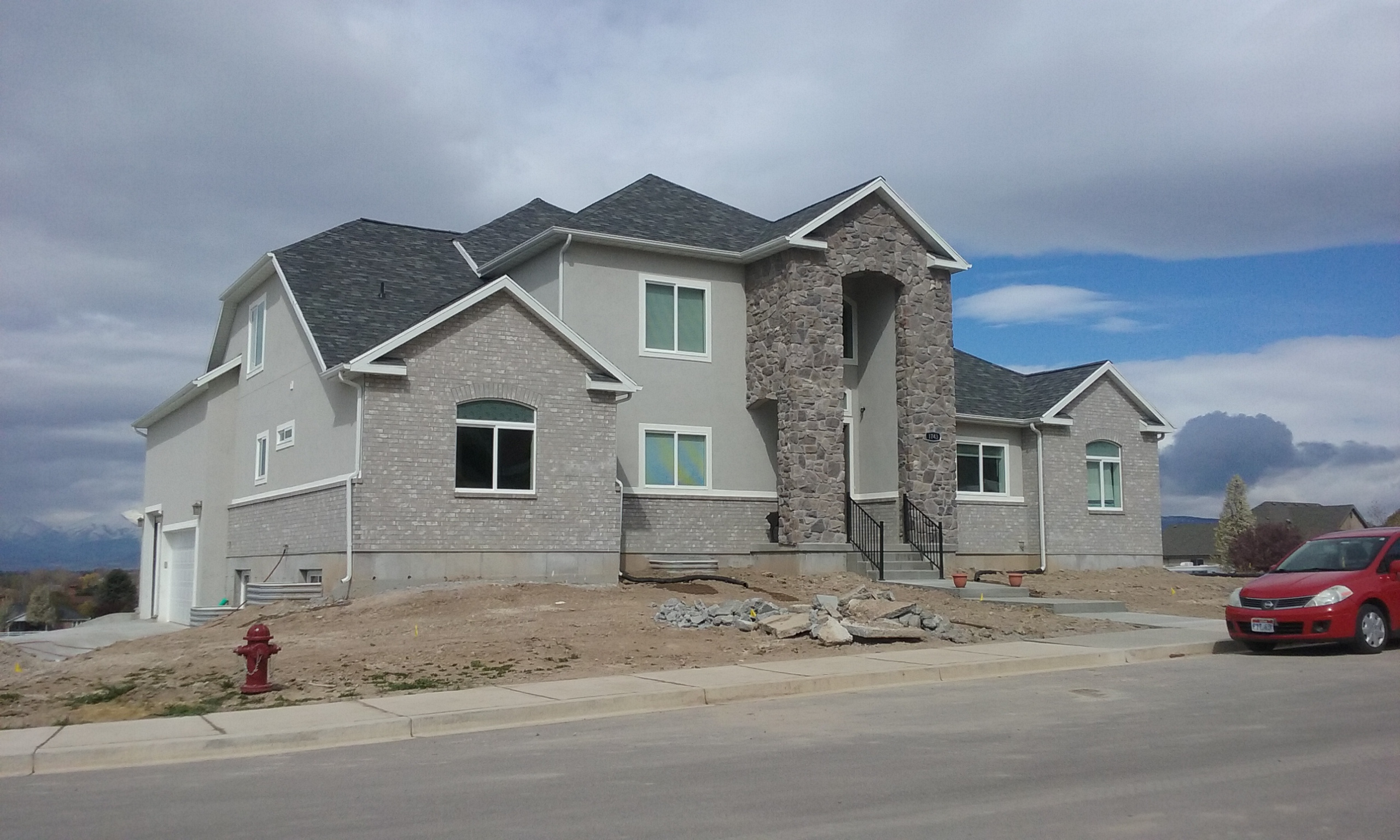
| Property Address: 1743 N 320 EAST - PLEASANT GROVE
more see "Addrs" tab below..
|
|
| Mailing Address: 1743 N 320 E PLEASANT GROVE, UT 84062 |
|
| Acreage: 0.325566 |
|
| Last Document:
100492-2018
|
|
| Subdivision Map Filing |
|
| Taxing Description:
LOT 9, PLAT A, MAHOGANY VIEW SUB AREA 0.326 AC.
*Taxing description NOT FOR LEGAL DOCUMENTS
|
|
- Owner Names
- Value History
- Tax History
- Location
- Photos
- Documents
- Aerial Image
- Addrs
| |
----- Real Estate Values ----- |
---Improvements--- |
---Greenbelt--- |
Total |
| Year |
Com |
Res |
Agr |
Tot |
Com |
Res |
Agr |
Tot |
Land |
Homesite |
Tot |
Market Value |
| 2024 |
$0 |
$395,300 |
$0 |
$395,300 |
$0 |
$943,200 |
$0 |
$943,200 |
$0 |
$0 |
$0 |
$1,338,500 |
| 2023 |
$0 |
$359,400 |
$0 |
$359,400 |
$0 |
$1,033,100 |
$0 |
$1,033,100 |
$0 |
$0 |
$0 |
$1,392,500 |
| 2022 |
$0 |
$377,900 |
$0 |
$377,900 |
$0 |
$893,400 |
$0 |
$893,400 |
$0 |
$0 |
$0 |
$1,271,300 |
| 2021 |
$0 |
$236,200 |
$0 |
$236,200 |
$0 |
$618,900 |
$0 |
$618,900 |
$0 |
$0 |
$0 |
$855,100 |
| 2020 |
$0 |
$218,700 |
$0 |
$218,700 |
$0 |
$355,800 |
$0 |
$355,800 |
$0 |
$0 |
$0 |
$574,500 |
| 2019 |
$0 |
$203,100 |
$0 |
$203,100 |
$0 |
$0 |
$0 |
$0 |
$0 |
$0 |
$0 |
$203,100 |
| Year |
General Taxes |
Adjustments |
Net Taxes |
Fees |
Payments |
Tax Balance* |
Balance Due |
Tax District |
| 2025 |
$0.00 |
$0.00 |
$0.00 |
$0.00 |
|
$0.00
|
$0.00 |
070 - PLEASANT GROVE CITY |
| 2024 |
$0.00 |
$0.00 |
$0.00 |
$0.00 |
|
($145.52)
|
($145.52) |
070 - PLEASANT GROVE CITY |
| 2023 |
$6,268.69 |
($145.52) |
$6,123.17 |
$0.00 |
|
$0.00
|
$0.00 |
070 - PLEASANT GROVE CITY |
| 2022 |
$5,751.74 |
$0.00 |
$5,751.74 |
$0.00 |
|
$0.00
|
$0.00 |
070 - PLEASANT GROVE CITY |
| 2021 |
$4,619.81 |
$0.00 |
$4,619.81 |
$0.00 |
|
$0.00
|
$0.00 |
070 - PLEASANT GROVE CITY |
| 2020 |
$3,166.07 |
$0.00 |
$3,166.07 |
$0.00 |
|
$0.00
|
$0.00 |
070 - PLEASANT GROVE CITY |
| 2019 |
$1,967.84 |
$0.00 |
$1,967.84 |
$0.00 |
|
$0.00
|
$0.00 |
070 - PLEASANT GROVE CITY |
* Note: Original tax amount (Does not include applicable interest and/or fees).
| Entry # |
Date |
Recorded |
Type |
Party1 (Grantor) |
Party2 (Grantee) |
| 173892-2020 |
08/20/2020 |
11/03/2020 |
N |
BALL, TERRY |
WHOM OF INTEREST |
| 55850-2020 |
04/21/2020 |
04/28/2020 |
MOD AGR |
BALL, TERRY B |
UTAH COMMUNITY FEDERAL CREDIT UNION |
| 79351-2019 |
08/16/2019 |
08/19/2019 |
D TR |
BALL, TERRY B |
UTAH COMMUNITY FEDERAL CREDIT UNION |
| 79350-2019 |
08/16/2019 |
08/19/2019 |
WD |
BALL, TERRY BRIGGS & DEANNA |
BALL, TERRY B |
| 51004-2019 |
05/31/2019 |
06/06/2019 |
WD |
HARRIS, JERRY & SHERYL SMITH |
BALL, TERRY BRIGGS & DEANNA |
| 358-2019 |
12/27/2018 |
01/03/2019 |
REC |
UTAH COMMUNITY FEDERAL CREDIT UNION TEE |
SMITH, CRAIG H & LINDA L |
| 357-2019 |
12/27/2018 |
01/03/2019 |
REC |
UTAH COMMUNITY FEDERAL CREDIT UNION TEE |
SMITH, CRAIG H & LINDA L (ET AL) |
| 105732-2018 |
11/02/2018 |
11/05/2018 |
R FARM |
UTAH COUNTY TREASURER |
SMITH, HARVEY E & LINDA L (ET AL) |
| 101165-2018 |
10/12/2018 |
10/22/2018 |
QCD |
SMITH, CRAIG H & LINDA L |
HARRIS, JERRY & SHERYL SMITH |
| 100492-2018 |
02/20/2018 |
10/19/2018 |
S PLAT |
SMITH, CRAIG H & LINDA L (ET AL) |
MAHOGANY VIEW PLAT A |
1743 N 320 EAST - PLEASANT GROVE
315 E 1700 NORTH - PLEASANT GROVE
Main Menu Comments or Concerns on Value/Appraisal - Assessor's Office
Documents/Owner/Parcel information - Recorder's Office
Address Change for Tax Notice
This page was created on 8/29/2024 7:07:33 AM |

