Property Information
mobile view
| Serial Number: 09:001:0003 |
Serial Life: 1981... |
|
|
 Total Photos: 1
|
| |
|
|
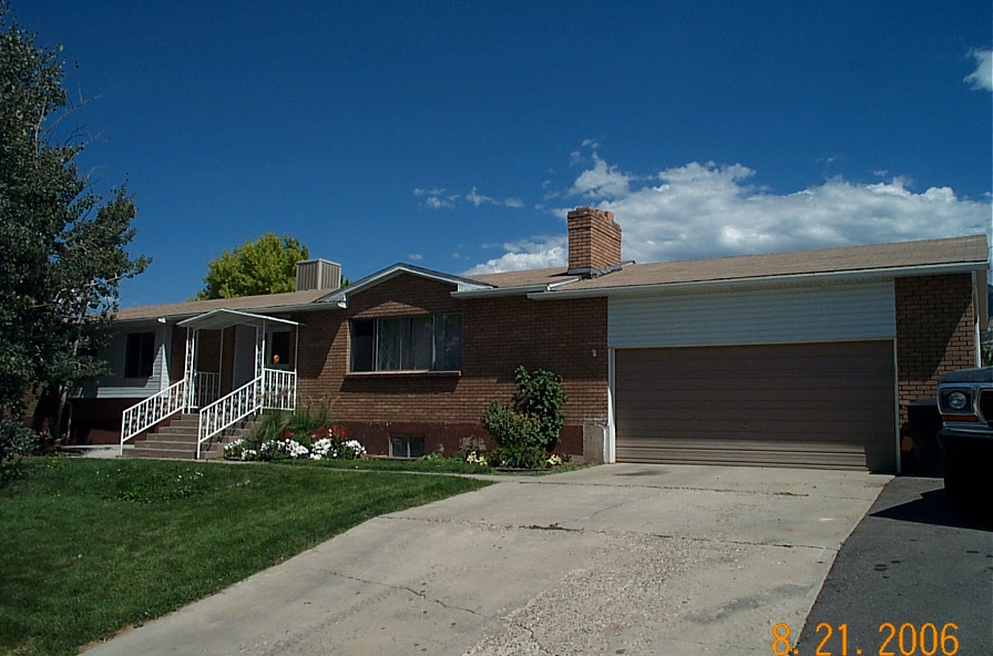
| Property Address: 325 S 450 EAST - SALEM |
|
| Mailing Address: 325 S 450 E SALEM, UT 84653-9210 |
|
| Acreage: 0.28 |
|
| Last Document:
31260-1980
|
|
| Subdivision Map Filing |
|
| Taxing Description:
COM N 2810.917 FT & W 277.126 FT FR S 1/4 COR SEC 12, T9S, R2E, SLM; S 89 49'53"E 120 FT; S 31'31"W 103 FT; N 88 49'53"W 120 FT; N 31'31"E 103 FT TO BEG. AREA .28 ACRE.
*Taxing description NOT FOR LEGAL DOCUMENTS
|
|
- Owner Names
- Value History
- Tax History
- Location
- Photos
- Documents
- Aerial Image
| 2004... |
|
COFFMAN, DAVID L |
|
| 2004... |
|
COFFMAN, NANCY A |
|
| 1994-2003 |
|
STEWART, PEGGY S |
|
| 1994-2003 |
|
STEWART, REX K JR |
|
| 1988-1993 |
|
STEWART, PEGGY S |
|
| 1988-1993 |
|
STEWART, REX K |
|
| 1987 |
|
STEWART, PEGGY S |
|
| 1987 |
|
STEWART, REX K |
|
| 1986 |
|
MOUNTAIN AMERICA CREDIT UNION |
|
| 1983-1985 |
|
MORLEY, RAY GERALD |
|
| 1983-1985 |
|
MORLEY, SANDRA C |
|
| 1981-1982 |
|
MORLEY, RAY GERALD |
|
| 1981-1982 |
|
MORLEY, SANDRA C |
|
| |
----- Real Estate Values ----- |
---Improvements--- |
---Greenbelt--- |
Total |
| Year |
Com |
Res |
Agr |
Tot |
Com |
Res |
Agr |
Tot |
Land |
Homesite |
Tot |
Market Value |
| 2024 |
$0 |
$157,100 |
$0 |
$157,100 |
$0 |
$340,500 |
$0 |
$340,500 |
$0 |
$0 |
$0 |
$497,600 |
| 2023 |
$0 |
$152,500 |
$0 |
$152,500 |
$0 |
$361,100 |
$0 |
$361,100 |
$0 |
$0 |
$0 |
$513,600 |
| 2022 |
$0 |
$153,000 |
$0 |
$153,000 |
$0 |
$365,400 |
$0 |
$365,400 |
$0 |
$0 |
$0 |
$518,400 |
| 2021 |
$0 |
$95,600 |
$0 |
$95,600 |
$0 |
$281,100 |
$0 |
$281,100 |
$0 |
$0 |
$0 |
$376,700 |
| 2020 |
$0 |
$86,900 |
$0 |
$86,900 |
$0 |
$265,200 |
$0 |
$265,200 |
$0 |
$0 |
$0 |
$352,100 |
| 2019 |
$0 |
$83,100 |
$0 |
$83,100 |
$0 |
$230,600 |
$0 |
$230,600 |
$0 |
$0 |
$0 |
$313,700 |
| 2018 |
$0 |
$75,600 |
$0 |
$75,600 |
$0 |
$217,000 |
$0 |
$217,000 |
$0 |
$0 |
$0 |
$292,600 |
| 2017 |
$0 |
$66,500 |
$0 |
$66,500 |
$0 |
$217,000 |
$0 |
$217,000 |
$0 |
$0 |
$0 |
$283,500 |
| 2016 |
$0 |
$60,500 |
$0 |
$60,500 |
$0 |
$217,000 |
$0 |
$217,000 |
$0 |
$0 |
$0 |
$277,500 |
| 2015 |
$0 |
$56,700 |
$0 |
$56,700 |
$0 |
$188,700 |
$0 |
$188,700 |
$0 |
$0 |
$0 |
$245,400 |
| 2014 |
$0 |
$56,700 |
$0 |
$56,700 |
$0 |
$181,700 |
$0 |
$181,700 |
$0 |
$0 |
$0 |
$238,400 |
| 2013 |
$0 |
$52,500 |
$0 |
$52,500 |
$0 |
$158,000 |
$0 |
$158,000 |
$0 |
$0 |
$0 |
$210,500 |
| 2012 |
$0 |
$43,400 |
$0 |
$43,400 |
$0 |
$144,700 |
$0 |
$144,700 |
$0 |
$0 |
$0 |
$188,100 |
| 2011 |
$0 |
$45,000 |
$0 |
$45,000 |
$0 |
$155,100 |
$0 |
$155,100 |
$0 |
$0 |
$0 |
$200,100 |
| 2010 |
$0 |
$53,133 |
$0 |
$53,133 |
$0 |
$159,560 |
$0 |
$159,560 |
$0 |
$0 |
$0 |
$212,693 |
| 2009 |
$0 |
$69,200 |
$0 |
$69,200 |
$0 |
$153,800 |
$0 |
$153,800 |
$0 |
$0 |
$0 |
$223,000 |
| 2008 |
$0 |
$69,200 |
$0 |
$69,200 |
$0 |
$180,800 |
$0 |
$180,800 |
$0 |
$0 |
$0 |
$250,000 |
| 2007 |
$0 |
$72,800 |
$0 |
$72,800 |
$0 |
$179,400 |
$0 |
$179,400 |
$0 |
$0 |
$0 |
$252,200 |
| 2006 |
$0 |
$34,300 |
$0 |
$34,300 |
$0 |
$125,800 |
$0 |
$125,800 |
$0 |
$0 |
$0 |
$160,100 |
| 2005 |
$0 |
$33,000 |
$0 |
$33,000 |
$0 |
$121,000 |
$0 |
$121,000 |
$0 |
$0 |
$0 |
$154,000 |
| 2004 |
$0 |
$33,000 |
$0 |
$33,000 |
$0 |
$121,000 |
$0 |
$121,000 |
$0 |
$0 |
$0 |
$154,000 |
| 2003 |
$0 |
$33,134 |
$0 |
$33,134 |
$0 |
$156,974 |
$0 |
$156,974 |
$0 |
$0 |
$0 |
$190,108 |
| 2002 |
$0 |
$33,134 |
$0 |
$33,134 |
$0 |
$156,974 |
$0 |
$156,974 |
$0 |
$0 |
$0 |
$190,108 |
| 2001 |
$0 |
$33,134 |
$0 |
$33,134 |
$0 |
$156,974 |
$0 |
$156,974 |
$0 |
$0 |
$0 |
$190,108 |
| 2000 |
$0 |
$30,966 |
$0 |
$30,966 |
$0 |
$146,773 |
$0 |
$146,773 |
$0 |
$0 |
$0 |
$177,739 |
| 1999 |
$0 |
$30,966 |
$0 |
$30,966 |
$0 |
$146,773 |
$0 |
$146,773 |
$0 |
$0 |
$0 |
$177,739 |
| 1998 |
$0 |
$30,966 |
$0 |
$30,966 |
$0 |
$146,773 |
$0 |
$146,773 |
$0 |
$0 |
$0 |
$177,739 |
| 1997 |
$0 |
$30,966 |
$0 |
$30,966 |
$0 |
$146,773 |
$0 |
$146,773 |
$0 |
$0 |
$0 |
$177,739 |
| 1996 |
$0 |
$28,215 |
$0 |
$28,215 |
$0 |
$133,734 |
$0 |
$133,734 |
$0 |
$0 |
$0 |
$161,949 |
| 1995 |
$0 |
$25,650 |
$0 |
$25,650 |
$0 |
$133,734 |
$0 |
$133,734 |
$0 |
$0 |
$0 |
$159,384 |
| 1994 |
$0 |
$15,000 |
$0 |
$15,000 |
$0 |
$107,850 |
$0 |
$107,850 |
$0 |
$0 |
$0 |
$122,850 |
| 1993 |
$0 |
$13,844 |
$0 |
$13,844 |
$0 |
$121,213 |
$0 |
$121,213 |
$0 |
$0 |
$0 |
$135,057 |
| 1992 |
$0 |
$12,701 |
$0 |
$12,701 |
$0 |
$72,349 |
$0 |
$72,349 |
$0 |
$0 |
$0 |
$85,050 |
| 1991 |
$0 |
$11,141 |
$0 |
$11,141 |
$0 |
$51,859 |
$0 |
$51,859 |
$0 |
$0 |
$0 |
$63,000 |
| 1990 |
$0 |
$11,141 |
$0 |
$11,141 |
$0 |
$51,859 |
$0 |
$51,859 |
$0 |
$0 |
$0 |
$63,000 |
| 1989 |
$0 |
$11,141 |
$0 |
$11,141 |
$0 |
$51,859 |
$0 |
$51,859 |
$0 |
$0 |
$0 |
$63,000 |
| 1988 |
$0 |
$11,142 |
$0 |
$11,142 |
$0 |
$48,858 |
$0 |
$48,858 |
$0 |
$0 |
$0 |
$60,000 |
| 1987 |
$0 |
$11,142 |
$0 |
$11,142 |
$0 |
$48,858 |
$0 |
$48,858 |
$0 |
$0 |
$0 |
$60,000 |
| 1986 |
$0 |
$11,142 |
$0 |
$11,142 |
$0 |
$48,859 |
$0 |
$48,859 |
$0 |
$0 |
$0 |
$60,001 |
| 1985 |
$0 |
$11,142 |
$0 |
$11,142 |
$0 |
$83,933 |
$0 |
$83,933 |
$0 |
$0 |
$0 |
$95,075 |
| 1984 |
$0 |
$11,258 |
$0 |
$11,258 |
$0 |
$84,783 |
$0 |
$84,783 |
$0 |
$0 |
$0 |
$96,041 |
| Year |
General Taxes |
Adjustments |
Net Taxes |
Fees |
Payments |
Tax Balance* |
Balance Due |
Tax District |
| 2025 |
$0.00 |
$0.00 |
$0.00 |
$0.00 |
|
$0.00
|
$0.00 |
180 - SALEM CITY |
| 2024 |
$2,698.48 |
$0.00 |
$2,698.48 |
$0.00 |
|
$0.00
|
$0.00 |
180 - SALEM CITY |
| 2023 |
$2,780.45 |
$0.00 |
$2,780.45 |
$0.00 |
|
$0.00
|
$0.00 |
180 - SALEM CITY |
| 2022 |
$2,850.34 |
$0.00 |
$2,850.34 |
$0.00 |
|
$0.00
|
$0.00 |
180 - SALEM CITY |
| 2021 |
$2,346.99 |
$0.00 |
$2,346.99 |
$0.00 |
|
$0.00
|
$0.00 |
180 - SALEM CITY |
| 2020 |
$2,254.34 |
$0.00 |
$2,254.34 |
$0.00 |
|
$0.00
|
$0.00 |
180 - SALEM CITY |
| 2019 |
$1,966.73 |
$0.00 |
$1,966.73 |
$0.00 |
|
$0.00
|
$0.00 |
180 - SALEM CITY |
| 2018 |
$1,919.41 |
$0.00 |
$1,919.41 |
$0.00 |
|
$0.00
|
$0.00 |
180 - SALEM CITY |
| 2017 |
$1,917.88 |
$0.00 |
$1,917.88 |
$0.00 |
|
$0.00
|
$0.00 |
180 - SALEM CITY |
| 2016 |
$1,899.27 |
$0.00 |
$1,899.27 |
$0.00 |
|
$0.00
|
$0.00 |
180 - SALEM CITY |
| 2015 |
$1,709.80 |
$0.00 |
$1,709.80 |
$0.00 |
|
$0.00
|
$0.00 |
180 - SALEM CITY |
| 2014 |
$1,658.67 |
$0.00 |
$1,658.67 |
$0.00 |
|
$0.00
|
$0.00 |
180 - SALEM CITY |
| 2013 |
$1,534.13 |
$0.00 |
$1,534.13 |
$0.00 |
|
$0.00
|
$0.00 |
180 - SALEM CITY |
| 2012 |
$1,396.64 |
$0.00 |
$1,396.64 |
$0.00 |
|
$0.00
|
$0.00 |
180 - SALEM CITY |
| 2011 |
$1,447.33 |
$0.00 |
$1,447.33 |
$0.00 |
|
$0.00
|
$0.00 |
180 - SALEM CITY |
| 2010 |
$1,429.98 |
$0.00 |
$1,429.98 |
$0.00 |
|
$0.00
|
$0.00 |
180 - SALEM CITY |
| 2009 |
$1,414.40 |
$0.00 |
$1,414.40 |
$0.00 |
|
$0.00
|
$0.00 |
180 - SALEM CITY |
| 2008 |
$1,459.01 |
$0.00 |
$1,459.01 |
$0.00 |
|
$0.00
|
$0.00 |
180 - SALEM CITY |
| 2007 |
$1,472.96 |
$0.00 |
$1,472.96 |
$0.00 |
|
$0.00
|
$0.00 |
180 - SALEM CITY |
| 2006 |
$1,041.78 |
$0.00 |
$1,041.78 |
$0.00 |
|
$0.00
|
$0.00 |
180 - SALEM CITY |
| 2005 |
$1,066.12 |
$0.00 |
$1,066.12 |
$0.00 |
|
$0.00
|
$0.00 |
180 - SALEM CITY |
| 2004 |
$1,068.91 |
$0.00 |
$1,068.91 |
$0.00 |
|
$0.00
|
$0.00 |
180 - SALEM CITY |
| 2003 |
$1,199.41 |
$0.00 |
$1,199.41 |
$0.00 |
|
$0.00
|
$0.00 |
180 - SALEM CITY |
| 2002 |
$1,171.70 |
$0.00 |
$1,171.70 |
$0.00 |
|
$0.00
|
$0.00 |
180 - SALEM CITY |
| 2001 |
$1,187.28 |
$0.00 |
$1,187.28 |
$0.00 |
|
$0.00
|
$0.00 |
180 - SALEM CITY |
| 2000 |
$1,100.44 |
$0.00 |
$1,100.44 |
$0.00 |
|
$0.00
|
$0.00 |
180 - SALEM CITY |
| 1999 |
$1,046.38 |
$0.00 |
$1,046.38 |
$0.00 |
|
$0.00
|
$0.00 |
180 - SALEM CITY |
| 1998 |
$1,024.97 |
$0.00 |
$1,024.97 |
$0.00 |
|
$0.00
|
$0.00 |
180 - SALEM CITY |
| 1997 |
$1,120.67 |
$0.00 |
$1,120.67 |
$0.00 |
|
$0.00
|
$0.00 |
180 - SALEM CITY |
| 1996 |
$1,001.26 |
$0.00 |
$1,001.26 |
$0.00 |
|
$0.00
|
$0.00 |
180 - SALEM CITY |
| 1995 |
$990.49 |
$0.00 |
$990.49 |
$0.00 |
|
$0.00
|
$0.00 |
180 - SALEM CITY |
| 1994 |
$1,181.39 |
$0.00 |
$1,181.39 |
$0.00 |
|
$0.00
|
$0.00 |
180 - SALEM CITY |
| 1993 |
$1,187.12 |
$0.00 |
$1,187.12 |
$0.00 |
|
$0.00
|
$0.00 |
180 - SALEM CITY |
| 1992 |
$721.42 |
$0.00 |
$721.42 |
$0.00 |
|
$0.00
|
$0.00 |
180 - SALEM CITY |
| 1991 |
$590.21 |
$0.00 |
$590.21 |
$0.00 |
|
$0.00
|
$0.00 |
180 - SALEM CITY |
| 1990 |
$575.54 |
$0.00 |
$575.54 |
$0.00 |
|
$0.00
|
$0.00 |
180 - SALEM CITY |
| 1989 |
$590.63 |
$0.00 |
$590.63 |
$0.00 |
|
$0.00
|
$0.00 |
180 - SALEM CITY |
| 1988 |
$565.56 |
$0.00 |
$565.56 |
$0.00 |
|
$0.00
|
$0.00 |
180 - SALEM CITY |
| 1987 |
$565.74 |
$0.00 |
$565.74 |
$0.00 |
|
$0.00
|
$0.00 |
180 - SALEM CITY |
| 1986 |
$536.72 |
$0.00 |
$536.72 |
$0.00 |
|
$0.00
|
$0.00 |
180 - SALEM CITY |
| 1985 |
$834.00 |
$0.00 |
$834.00 |
$0.00 |
|
$0.00
|
$0.00 |
180 - SALEM CITY |
| 1984 |
$811.94 |
$0.00 |
$811.94 |
$0.00 |
|
$0.00
|
$0.00 |
180 - SALEM CITY |
* Note: Original tax amount (Does not include applicable interest and/or fees).
| Entry # |
Date |
Recorded |
Type |
Party1 (Grantor) |
Party2 (Grantee) |
| 53709-2023 |
08/11/2023 |
08/16/2023 |
RC |
AMERICA FIRST FEDERAL CREDIT UNION |
WHOM OF INTEREST |
| 51974-2023 |
08/07/2023 |
08/09/2023 |
TR D |
COFFMAN, DAVID L & NANCY A |
AMERICA FIRST FEDERAL CREDIT UNION |
| 25872-2021 |
02/04/2021 |
02/10/2021 |
RSUBTEE |
MORTGAGE ELECTRONIC REGISTRATION SYSTEMS INC (ET AL) |
COFFMAN, DAVID L & NANCY A |
| 191231-2020 |
11/27/2020 |
12/02/2020 |
D TR |
COFFMAN, DAVID L & NANCY A |
INTERCAP LENDING INC |
| 128840-2019 |
12/04/2019 |
12/05/2019 |
REC |
FIRST AMERICAN TITLE INSURANCE COMPANY TEE |
COFFMAN, DAVID L & NANCY A |
| 128839-2019 |
12/04/2019 |
12/05/2019 |
SUB TEE |
MORTGAGE ELECTRONIC REGISTRATION SYSTEMS INC |
FIRST AMERICAN TITLE INSURANCE COMPANY SUBTEE |
| 98234-2019 |
09/25/2019 |
09/30/2019 |
D TR |
COFFMAN, DAVID L & NANCY A |
INTERCAP LENDING INC |
| 116722-2016 |
11/15/2016 |
11/18/2016 |
REC |
AMERICA FIRST FEDERAL CREDIT UNION TEE |
COFFMAN, DAVID L & NANCY A |
| 102866-2016 |
10/07/2016 |
10/14/2016 |
RSUBTEE |
MORTGAGE ELECTRONIC REGISTRATION SYSTEMS INC (ET AL) |
COFFMAN, DAVID L & NANCY A |
| 98308-2016 |
09/30/2016 |
10/05/2016 |
D TR |
COFFMAN, DAVID L & NANCY A |
VERITAS FUNDING LLC |
| 14703-2015 |
02/09/2015 |
02/25/2015 |
RC |
AMERICA FIRST FEDERAL CREDIT UNION |
WHOM OF INTEREST |
| 10614-2015 |
02/09/2015 |
02/11/2015 |
TR D |
COFFMAN, DAVID L & NANCY A |
AMERICA FIRST FEDERAL CREDIT UNION |
| 3187-2015 |
12/04/2014 |
01/14/2015 |
QCD |
UNITED STATES OF AMERICA |
SOUTH UTAH VALLEY ELECTRIC SERVICE DISTRICT |
| 89194-2010 |
09/22/2010 |
10/18/2010 |
RSUBTEE |
MORTGAGE ELECTRONIC REGISTRATION SYSTEMS INC (ET AL) |
COFFMAN, DAVID L & NANCY A |
| 83243-2010 |
09/20/2010 |
09/30/2010 |
REC |
USAA FEDERAL SAVINGS BANK TEE |
COFFMAN, NANCY A & DAVID L |
| 83242-2010 |
09/20/2010 |
09/30/2010 |
SUB TEE |
USAA FEDERAL SAVINGS BANK |
USAA FEDERAL SAVINGS BANK SUCTEE |
| 77086-2010 |
09/08/2010 |
09/13/2010 |
D TR |
COFFMAN, DAVID L & NANCY A |
M&T BANK |
| 114949-2008 |
10/20/2008 |
10/22/2008 |
CT |
STATE OF UTAH |
WHOM OF INTEREST |
| 107508-2008 |
09/30/2008 |
09/30/2008 |
RESOL |
BOARD OF COUNTY COMMISSIONERS UTAH COUNTY |
WHOM OF INTEREST |
| 100737-2008 |
08/25/2008 |
09/11/2008 |
D TR |
COFFMAN, NANCY A & DAVID L |
USAA FEDERAL SAVINGS BANK |
| 180160-2003 |
10/23/2003 |
11/13/2003 |
REC |
LUNDBERG, J SCOTT TEE |
STEWART, REX K JR & PEGGY S |
| 180159-2003 |
09/24/2003 |
11/13/2003 |
SUB TEE |
ADVANTA NATIONAL BANK |
LUNDBERG, J SCOTT SUCTEE |
| 116282-2003 |
07/25/2003 |
07/29/2003 |
D TR |
COFFMAN, DAVID L & NANCY A |
MORTGAGE COMPANY THE |
| 116281-2003 |
07/28/2003 |
07/29/2003 |
WD |
STEWART, REX K JR & PEGGY S |
COFFMAN, DAVID L & NANCY A |
| 50976-2003 |
04/24/2000 |
04/03/2003 |
AS |
ADVANTA NATIONAL BANK |
BANKERS TRUST COMPANY OF CALIFORNIA |
| 43459-2003 |
03/20/2003 |
03/24/2003 |
ND |
LUNDBERG, SCOTT TEE |
STEWART, REX K JR & PEGGY S |
| 43458-2003 |
03/07/2003 |
03/24/2003 |
SUB TEE |
DEUTSCHE BANK NATIONAL TRUST COMPANY |
LUNDBERG, SCOTT SUCTEE |
| 31759-2000 |
04/10/2000 |
04/24/2000 |
D TR |
STEWART, REX K JR & PEGGY S |
ADVANTA NATIONAL BANK |
| 63245-1999 |
09/15/1998 |
05/28/1999 |
AS |
FREEDOM MORTGAGE CORPORATION |
FIRST UNION NATIONAL BANK TEE |
| 67753-1998 |
06/22/1998 |
07/07/1998 |
REC |
NATIONS BANK TEE |
STEWART, REX K JR & PEGGY S |
| 67752-1998 |
06/22/1998 |
07/07/1998 |
SUB TEE |
NATIONS BANC MORTGAGE CORPORATION |
NATIONS BANK SUBTEE |
| 45154-1998 |
04/16/1998 |
05/06/1998 |
REC |
NATIONS BANK TEE |
STEWART, REX K JR & PEGGY S |
| 25273-1998 |
03/11/1998 |
03/17/1998 |
REC |
OREM COMMUNITY BANK TEE |
STEWART, REX K JR & PEGGY S |
| 19166-1998 |
02/23/1998 |
03/02/1998 |
D TR |
STEWART, REX K & PEGGY S |
FREEDOM MORTGAGE CORPORATION |
| 58760-1996 |
07/09/1996 |
07/17/1996 |
REC |
UNITED SAVINGS BANK TEE |
STEWART, REX K & PEGGY S |
| 54504-1996 |
07/01/1996 |
07/01/1996 |
RC |
OREM COMMUNITY BANK |
WHOM OF INTEREST |
| 54503-1996 |
06/26/1996 |
07/01/1996 |
D TR |
STEWART, REX K JR & PEGGY S |
OREM COMMUNITY BANK |
| 8002-1996 |
11/01/1995 |
01/31/1996 |
AS |
EXPRESS AMERICA MORTGAGE CORPORATION |
NATIONS BANC MORTGAGE CORPORATION |
| 19978-1994 |
02/12/1994 |
03/09/1994 |
AS |
DIRECTORS MORTGAGE LOAN CORPORATION DBA (ET AL) |
EXPRESS AMERICA MORTGAGE CORPORATION |
| 19791-1994 |
06/11/1993 |
03/09/1994 |
D TR |
STEWART, REX K JR & PEGGY S |
DIRECTORS MORTGAGE LOAN CORPORATION DBA (ET AL) |
| 9935-1994 |
09/27/1993 |
02/03/1994 |
REC |
BATES, MARLON L TEE |
STEWART, REX K JR & PEGGY S |
| 9934-1994 |
09/27/1993 |
02/03/1994 |
SUB TEE |
MOUNTAIN AMERICA CREDIT UNION |
BATES, MARLON L SUBTEE |
| 9005-1994 |
08/17/1993 |
02/01/1994 |
REC |
BATES, MARLON L TEE |
MORLEY, SANDRA C & RAY GERALD TEE |
| 9004-1994 |
08/17/1993 |
02/01/1994 |
SUB TEE |
MOUNTAIN AMERICA CREDIT UNION FKA (ET AL) |
BATES, MARLON L SUBTEE |
| 71688-1993 |
08/16/1993 |
10/12/1993 |
REC |
FAR WEST BANK TEE |
STEWART, REX K & PEGGY S |
| 55053-1993 |
08/09/1993 |
08/13/1993 |
RC |
UNITED SAVINGS BANK |
WHOM OF INTEREST |
| 55052-1993 |
08/09/1993 |
08/13/1993 |
D TR |
STEWART, REX K & PEGGY S |
UNITED SAVINGS BANK |
| 42554-1993 |
06/11/1993 |
06/29/1993 |
WD |
STEWART, REX K & PEGGY S |
STEWART, REX K JR & PEGGY S |
| 7440-1993 |
02/01/1993 |
02/09/1993 |
REC |
BATES, MARLON L TEE |
STEWART, REX K & PEGGY S |
| 7439-1993 |
02/01/1993 |
02/09/1993 |
SUB TEE |
MOUNTAIN AMERICA CREDIT UNION |
BATES, MARLON L SUBTEE |
| 70520-1992 |
12/11/1992 |
12/23/1992 |
D TR |
STEWART, REX K & PEGGY S |
FAR WEST BANK |
| 44970-1987 |
12/01/1987 |
12/14/1987 |
REC |
ZIONS FIRST NATIONAL BANK TEE |
MORLEY, RAY G & SANDRA C |
| 15770-1987 |
04/20/1987 |
04/24/1987 |
NA AGR |
STEWART, REX K JR & PEGGY S |
MOUNTAIN AMERICA CREDIT UNION |
| 15769-1987 |
04/20/1987 |
04/24/1987 |
D TR |
STEWART, REX K JR & PEGGY S |
MOUNTAIN AMERICA CREDIT UNION |
| 25249-1986 |
07/22/1986 |
08/05/1986 |
TR D |
STEWART, REX K & PEGGY S |
MOUNTAIN AMERICA CREDIT UNION |
| 23516-1986 |
07/22/1986 |
07/22/1986 |
TR D |
STEWART, REX K & PEGGY S |
MOUNTAIN AMERICA CREDIT UNION |
| 23501-1986 |
07/15/1986 |
07/22/1986 |
WD |
MOUNTAIN AMERICA CREDIT UNION |
STEWART, REX K & PEGGY S |
| 15504-1985 |
05/10/1985 |
06/03/1985 |
WD |
MORLEY, SANDRA G & RAY GERALD |
MOUNTAIN AMERICA CREDIT UNION |
| 4890-1985 |
02/21/1985 |
02/25/1985 |
CANNTES |
RICHARDS, BRUCE L SUCTEE |
MORLEY, SANDRA C & RAY GERALD |
| 4732-1985 |
10/10/1984 |
02/22/1985 |
ND |
RICHARDS, BRUCE L SUCTEE |
MORLEY, SANDRA C & RAY GERALD TEE |
| 4731-1985 |
09/24/1984 |
02/22/1985 |
SUB TEE |
MOUNTAIN AMERICA CREDIT UNION FKA (ET AL) |
RICHARDS, BRUCE L SUCTEE |
| 3574-1985 |
02/05/1985 |
02/08/1985 |
N TEE S |
RICHARDS, BRUCE L SUCTEE |
WHOM OF INTEREST |
| 16182-1983 |
05/25/1983 |
06/02/1983 |
NA AGR |
MORLEY, SANDRA C & RAY GERALD |
UTELCU CREDIT UNION |
| 16181-1983 |
05/25/1983 |
06/02/1983 |
D TR |
MORLEY, SANDRA C & RAY GERALD TEE |
UTELCU CREDIT UNION |
| 15411-1983 |
05/24/1983 |
05/25/1983 |
REC |
WESTERN STATES TITLE COMPANY TEE |
MORLEY, RAY G & SANDRA C |
| 43958-1980 |
12/19/1980 |
12/23/1980 |
RC |
LOCKHART COMPANY THE |
WHOM OF INTEREST |
| 31260-1980 |
09/11/1980 |
09/11/1980 |
QCD |
MORLEY, RAY G & SANDRA C |
MORLEY, SANDRA C & RAY GERALD TEE |
| 29640-1980 |
08/25/1980 |
09/02/1980 |
REC |
UTAH VALLEY BANK TEE |
MORLEY, RAY G & SANDY |
| 28872-1980 |
08/25/1980 |
08/26/1980 |
TR D |
MORLEY, RAY G & SANDRA C |
LOCKHART COMPANY THE |
| 28795-1980 |
08/22/1980 |
08/26/1980 |
REC |
ZIONS FIRST NATIONAL BANK TEE |
ANDERSON, JOHN ALFRED JR & NANCY SUSANNE |
Main Menu Comments or Concerns on Value/Appraisal - Assessor's Office
Documents/Owner/Parcel information - Recorder's Office
Address Change for Tax Notice
This page was created on 3/21/2025 12:33:23 PM |