Property Information
mobile view
| Serial Number: 26:064:0016 |
Serial Life: 1980... |
|
|
 Total Photos: 4
|
| |
|
|
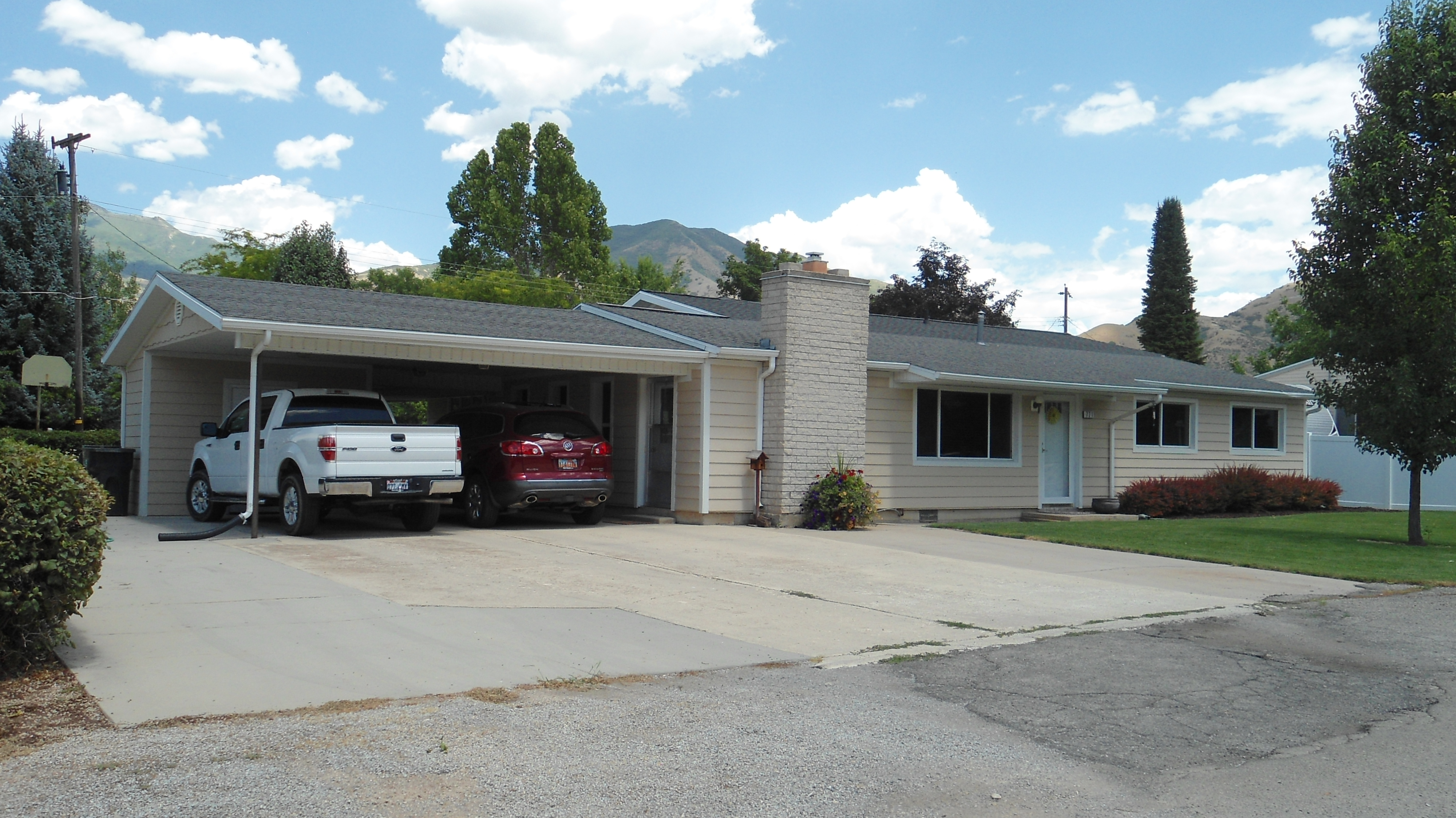
| Property Address: 771 E 300 NORTH - MAPLETON |
|
| Mailing Address: 771 E 300 N MAPLETON, UT 84664-3628 |
|
| Acreage: 0.29 |
|
| Last Document:
0-0
|
|
| Subdivision Map Filing |
|
| Taxing Description:
COM N 867.19 FT & E 2578.86 FT FR SW COR SEC 11, T8S, R3E, SLM; N 136.87 FT; S 89 DEG 56'50"E 100 FT; S 136.98 FT; N 89 DEG 53'W 100 FT TO BEG. AREA .31 ACRE.
*Taxing description NOT FOR LEGAL DOCUMENTS
|
|
- Owner Names
- Value History
- Tax History
- Location
- Photos
- Documents
- Aerial Image
| 2004... |
|
DIAMOND, LORIS EDWIN |
|
| 2004... |
|
DIAMOND, LU ANN |
|
| 2002-2003 |
|
DIAMOND, LORIS EDWIN |
|
| 2002-2003 |
|
DIAMOND, LU ANN |
|
| 1999-2001 |
|
DIAMOND, LORIS EDWIN |
|
| 1999-2001 |
|
DIAMOND, LU ANN |
|
| 1993-1998 |
|
DIAMOND, LORIS E |
|
| 1993-1998 |
|
DIAMOND, LU ANN L |
|
| 1987-1992 |
|
DIAMOND, LORIS E |
|
| 1987-1992 |
|
DIAMOND, LU ANN L |
|
| 1983-1986 |
|
DIAMOND, LORIS E |
|
| 1983-1986 |
|
DIAMOND, LU ANN L |
|
| 1980-1982 |
|
DIAMOND, LORIS E |
|
| 1980-1982 |
|
DIAMOND, LU ANN L |
|
| |
----- Real Estate Values ----- |
---Improvements--- |
---Greenbelt--- |
Total |
| Year |
Com |
Res |
Agr |
Tot |
Com |
Res |
Agr |
Tot |
Land |
Homesite |
Tot |
Market Value |
| 2024 |
$0 |
$236,300 |
$0 |
$236,300 |
$0 |
$214,200 |
$0 |
$214,200 |
$0 |
$0 |
$0 |
$450,500 |
| 2023 |
$0 |
$236,200 |
$0 |
$236,200 |
$0 |
$235,600 |
$0 |
$235,600 |
$0 |
$0 |
$0 |
$471,800 |
| 2022 |
$0 |
$251,800 |
$0 |
$251,800 |
$0 |
$222,400 |
$0 |
$222,400 |
$0 |
$0 |
$0 |
$474,200 |
| 2021 |
$0 |
$157,400 |
$0 |
$157,400 |
$0 |
$171,100 |
$0 |
$171,100 |
$0 |
$0 |
$0 |
$328,500 |
| 2020 |
$0 |
$139,300 |
$0 |
$139,300 |
$0 |
$171,100 |
$0 |
$171,100 |
$0 |
$0 |
$0 |
$310,400 |
| 2019 |
$0 |
$133,700 |
$0 |
$133,700 |
$0 |
$148,800 |
$0 |
$148,800 |
$0 |
$0 |
$0 |
$282,500 |
| 2018 |
$0 |
$112,600 |
$0 |
$112,600 |
$0 |
$124,000 |
$0 |
$124,000 |
$0 |
$0 |
$0 |
$236,600 |
| 2017 |
$0 |
$105,600 |
$0 |
$105,600 |
$0 |
$115,200 |
$0 |
$115,200 |
$0 |
$0 |
$0 |
$220,800 |
| 2016 |
$0 |
$98,500 |
$0 |
$98,500 |
$0 |
$100,200 |
$0 |
$100,200 |
$0 |
$0 |
$0 |
$198,700 |
| 2015 |
$0 |
$88,000 |
$0 |
$88,000 |
$0 |
$100,200 |
$0 |
$100,200 |
$0 |
$0 |
$0 |
$188,200 |
| 2014 |
$0 |
$84,400 |
$0 |
$84,400 |
$0 |
$95,700 |
$0 |
$95,700 |
$0 |
$0 |
$0 |
$180,100 |
| 2013 |
$0 |
$67,900 |
$0 |
$67,900 |
$0 |
$83,200 |
$0 |
$83,200 |
$0 |
$0 |
$0 |
$151,100 |
| 2012 |
$0 |
$73,100 |
$0 |
$73,100 |
$0 |
$74,300 |
$0 |
$74,300 |
$0 |
$0 |
$0 |
$147,400 |
| 2011 |
$0 |
$63,400 |
$0 |
$63,400 |
$0 |
$92,500 |
$0 |
$92,500 |
$0 |
$0 |
$0 |
$155,900 |
| 2010 |
$0 |
$65,500 |
$0 |
$65,500 |
$0 |
$100,196 |
$0 |
$100,196 |
$0 |
$0 |
$0 |
$165,696 |
| 2009 |
$0 |
$65,500 |
$0 |
$65,500 |
$0 |
$106,900 |
$0 |
$106,900 |
$0 |
$0 |
$0 |
$172,400 |
| 2008 |
$0 |
$81,900 |
$0 |
$81,900 |
$0 |
$90,500 |
$0 |
$90,500 |
$0 |
$0 |
$0 |
$172,400 |
| 2007 |
$0 |
$81,900 |
$0 |
$81,900 |
$0 |
$90,500 |
$0 |
$90,500 |
$0 |
$0 |
$0 |
$172,400 |
| 2006 |
$0 |
$78,000 |
$0 |
$78,000 |
$0 |
$90,500 |
$0 |
$90,500 |
$0 |
$0 |
$0 |
$168,500 |
| 2005 |
$0 |
$49,100 |
$0 |
$49,100 |
$0 |
$61,527 |
$0 |
$61,527 |
$0 |
$0 |
$0 |
$110,627 |
| 2004 |
$0 |
$49,100 |
$0 |
$49,100 |
$0 |
$61,527 |
$0 |
$61,527 |
$0 |
$0 |
$0 |
$110,627 |
| 2003 |
$0 |
$49,100 |
$0 |
$49,100 |
$0 |
$61,527 |
$0 |
$61,527 |
$0 |
$0 |
$0 |
$110,627 |
| 2002 |
$0 |
$49,100 |
$0 |
$49,100 |
$0 |
$61,527 |
$0 |
$61,527 |
$0 |
$0 |
$0 |
$110,627 |
| 2001 |
$0 |
$49,100 |
$0 |
$49,100 |
$0 |
$61,527 |
$0 |
$61,527 |
$0 |
$0 |
$0 |
$110,627 |
| 2000 |
$0 |
$45,888 |
$0 |
$45,888 |
$0 |
$57,529 |
$0 |
$57,529 |
$0 |
$0 |
$0 |
$103,417 |
| 1999 |
$0 |
$45,888 |
$0 |
$45,888 |
$0 |
$57,529 |
$0 |
$57,529 |
$0 |
$0 |
$0 |
$103,417 |
| 1998 |
$0 |
$45,888 |
$0 |
$45,888 |
$0 |
$57,529 |
$0 |
$57,529 |
$0 |
$0 |
$0 |
$103,417 |
| 1997 |
$0 |
$45,888 |
$0 |
$45,888 |
$0 |
$57,529 |
$0 |
$57,529 |
$0 |
$0 |
$0 |
$103,417 |
| 1996 |
$0 |
$39,830 |
$0 |
$39,830 |
$0 |
$49,934 |
$0 |
$49,934 |
$0 |
$0 |
$0 |
$89,764 |
| 1995 |
$0 |
$36,209 |
$0 |
$36,209 |
$0 |
$49,934 |
$0 |
$49,934 |
$0 |
$0 |
$0 |
$86,143 |
| 1994 |
$0 |
$21,175 |
$0 |
$21,175 |
$0 |
$40,269 |
$0 |
$40,269 |
$0 |
$0 |
$0 |
$61,444 |
| 1993 |
$0 |
$21,175 |
$0 |
$21,175 |
$0 |
$40,269 |
$0 |
$40,269 |
$0 |
$0 |
$0 |
$61,444 |
| 1992 |
$0 |
$19,427 |
$0 |
$19,427 |
$0 |
$36,944 |
$0 |
$36,944 |
$0 |
$0 |
$0 |
$56,371 |
| 1991 |
$0 |
$17,041 |
$0 |
$17,041 |
$0 |
$27,234 |
$0 |
$27,234 |
$0 |
$0 |
$0 |
$44,275 |
| 1990 |
$0 |
$17,041 |
$0 |
$17,041 |
$0 |
$27,234 |
$0 |
$27,234 |
$0 |
$0 |
$0 |
$44,275 |
| 1989 |
$0 |
$17,041 |
$0 |
$17,041 |
$0 |
$27,234 |
$0 |
$27,234 |
$0 |
$0 |
$0 |
$44,275 |
| 1988 |
$0 |
$17,042 |
$0 |
$17,042 |
$0 |
$26,518 |
$0 |
$26,518 |
$0 |
$0 |
$0 |
$43,560 |
| 1987 |
$0 |
$17,042 |
$0 |
$17,042 |
$0 |
$29,283 |
$0 |
$29,283 |
$0 |
$0 |
$0 |
$46,325 |
| 1986 |
$0 |
$17,042 |
$0 |
$17,042 |
$0 |
$29,284 |
$0 |
$29,284 |
$0 |
$0 |
$0 |
$46,326 |
| 1985 |
$0 |
$17,042 |
$0 |
$17,042 |
$0 |
$29,283 |
$0 |
$29,283 |
$0 |
$0 |
$0 |
$46,325 |
| 1984 |
$0 |
$17,217 |
$0 |
$17,217 |
$0 |
$29,575 |
$0 |
$29,575 |
$0 |
$0 |
$0 |
$46,792 |
| Year |
General Taxes |
Adjustments |
Net Taxes |
Fees |
Payments |
Tax Balance* |
Balance Due |
Tax District |
| 2025 |
$0.00 |
$0.00 |
$0.00 |
$0.00 |
|
$0.00
|
$0.00 |
140 - MAPLETON CITY |
| 2024 |
$2,529.29 |
$0.00 |
$2,529.29 |
$0.00 |
|
$0.00
|
$0.00 |
140 - MAPLETON CITY |
| 2023 |
$2,632.27 |
$0.00 |
$2,632.27 |
$0.00 |
|
$0.00
|
$0.00 |
140 - MAPLETON CITY |
| 2022 |
$2,675.65 |
$0.00 |
$2,675.65 |
$0.00 |
|
$0.00
|
$0.00 |
140 - MAPLETON CITY |
| 2021 |
$2,195.02 |
$0.00 |
$2,195.02 |
$0.00 |
|
$0.00
|
$0.00 |
140 - MAPLETON CITY |
| 2020 |
$2,144.24 |
$0.00 |
$2,144.24 |
$0.00 |
|
$0.00
|
$0.00 |
140 - MAPLETON CITY |
| 2019 |
$1,911.89 |
$0.00 |
$1,911.89 |
$0.00 |
|
$0.00
|
$0.00 |
140 - MAPLETON CITY |
| 2018 |
$1,682.06 |
$0.00 |
$1,682.06 |
$0.00 |
|
$0.00
|
$0.00 |
140 - MAPLETON CITY |
| 2017 |
$1,626.81 |
$0.00 |
$1,626.81 |
$0.00 |
|
$0.00
|
$0.00 |
140 - MAPLETON CITY |
| 2016 |
$1,472.72 |
$0.00 |
$1,472.72 |
$0.00 |
|
$0.00
|
$0.00 |
140 - MAPLETON CITY |
| 2015 |
$1,403.39 |
$0.00 |
$1,403.39 |
$0.00 |
|
$0.00
|
$0.00 |
140 - MAPLETON CITY |
| 2014 |
$1,367.55 |
$0.00 |
$1,367.55 |
$0.00 |
|
$0.00
|
$0.00 |
140 - MAPLETON CITY |
| 2013 |
$1,221.39 |
$0.00 |
$1,221.39 |
$0.00 |
|
$0.00
|
$0.00 |
140 - MAPLETON CITY |
| 2012 |
$1,218.73 |
$0.00 |
$1,218.73 |
$0.00 |
|
$0.00
|
$0.00 |
140 - MAPLETON CITY |
| 2011 |
$1,261.99 |
$0.00 |
$1,261.99 |
$0.00 |
|
$0.00
|
$0.00 |
140 - MAPLETON CITY |
| 2010 |
$1,303.57 |
$0.00 |
$1,303.57 |
$0.00 |
|
$0.00
|
$0.00 |
140 - MAPLETON CITY |
| 2009 |
$1,269.54 |
$0.00 |
$1,269.54 |
$0.00 |
|
$0.00
|
$0.00 |
140 - MAPLETON CITY |
| 2008 |
$1,156.42 |
$0.00 |
$1,156.42 |
$0.00 |
|
$0.00
|
$0.00 |
140 - MAPLETON CITY |
| 2007 |
$1,082.09 |
$0.00 |
$1,082.09 |
$0.00 |
|
$0.00
|
$0.00 |
140 - MAPLETON CITY |
| 2006 |
$1,144.17 |
$0.00 |
$1,144.17 |
$0.00 |
|
$0.00
|
$0.00 |
140 - MAPLETON CITY |
| 2005 |
$826.34 |
$0.00 |
$826.34 |
$0.00 |
|
$0.00
|
$0.00 |
140 - MAPLETON CITY |
| 2004 |
$827.43 |
$0.00 |
$827.43 |
$0.00 |
|
$0.00
|
$0.00 |
140 - MAPLETON CITY |
| 2003 |
$758.68 |
$0.00 |
$758.68 |
$0.00 |
|
$0.00
|
$0.00 |
140 - MAPLETON CITY |
| 2002 |
$737.32 |
$0.00 |
$737.32 |
$0.00 |
|
$0.00
|
$0.00 |
140 - MAPLETON CITY |
| 2001 |
$743.34 |
$0.00 |
$743.34 |
$0.00 |
|
$0.00
|
$0.00 |
140 - MAPLETON CITY |
| 2000 |
$687.50 |
$0.00 |
$687.50 |
$0.00 |
|
$0.00
|
$0.00 |
140 - MAPLETON CITY |
| 1999 |
$653.14 |
$0.00 |
$653.14 |
$0.00 |
|
$0.00
|
$0.00 |
140 - MAPLETON CITY |
| 1998 |
$641.54 |
$0.00 |
$641.54 |
$0.00 |
|
$0.00
|
$0.00 |
140 - MAPLETON CITY |
| 1997 |
$637.22 |
$0.00 |
$637.22 |
$0.00 |
|
$0.00
|
$0.00 |
140 - MAPLETON CITY |
| 1996 |
$539.38 |
$0.00 |
$539.38 |
$0.00 |
|
$0.00
|
$0.00 |
140 - MAPLETON CITY |
| 1995 |
$517.66 |
$0.00 |
$517.66 |
$0.00 |
|
$0.00
|
$0.00 |
140 - MAPLETON CITY |
| 1994 |
$572.00 |
$0.00 |
$572.00 |
$0.00 |
|
$0.00
|
$0.00 |
140 - MAPLETON CITY |
| 1993 |
$519.01 |
$0.00 |
$519.01 |
$0.00 |
|
$0.00
|
$0.00 |
140 - MAPLETON CITY |
| 1992 |
$466.65 |
$0.00 |
$466.65 |
$0.00 |
|
$0.00
|
$0.00 |
140 - MAPLETON CITY |
| 1991 |
$395.12 |
$0.00 |
$395.12 |
$0.00 |
|
$0.00
|
$0.00 |
140 - MAPLETON CITY |
| 1990 |
$390.24 |
$0.00 |
$390.24 |
$0.00 |
|
$0.00
|
$0.00 |
140 - MAPLETON CITY |
| 1989 |
$401.82 |
$0.00 |
$401.82 |
$0.00 |
|
$0.00
|
$0.00 |
140 - MAPLETON CITY |
| 1988 |
$398.78 |
$0.00 |
$398.78 |
$0.00 |
|
$0.00
|
$0.00 |
140 - MAPLETON CITY |
| 1987 |
$423.60 |
$0.00 |
$423.60 |
$0.00 |
|
$0.00
|
$0.00 |
140 - MAPLETON CITY |
| 1986 |
$401.14 |
$0.00 |
$401.14 |
$0.00 |
|
$0.00
|
$0.00 |
140 - MAPLETON CITY |
| 1985 |
$391.52 |
$0.00 |
$391.52 |
$0.00 |
|
$0.00
|
$0.00 |
140 - MAPLETON CITY |
| 1984 |
$376.04 |
$0.00 |
$376.04 |
$0.00 |
|
$0.00
|
$0.00 |
140 - MAPLETON CITY |
* Note: Original tax amount (Does not include applicable interest and/or fees).
| Entry # |
Date |
Recorded |
Type |
Party1 (Grantor) |
Party2 (Grantee) |
| 49667-2009 |
05/05/2009 |
05/05/2009 |
R LN |
STAKER & PARSON COMPANIES |
DIAMOND, LORIS & LU ANN TEE |
| 4839-2009 |
01/19/2009 |
01/20/2009 |
N LN |
DIAMOND, LORIS & LU ANN TEE |
STAKER & PARSON COMPANIES INC |
| 63441-2007 |
04/25/2007 |
04/30/2007 |
REC |
CENTRAL BANK TEE |
DIAMOND, LORIS EDWIN & LU ANN |
| 61358-2003 |
04/18/2003 |
04/22/2003 |
REC |
CENTRAL BANK TEE |
DIAMOND, LORIS EDWIN & LU ANN |
| 61357-2003 |
04/11/2003 |
04/22/2003 |
QCD |
DIAMOND, LORIS EDWIN & LU ANN |
DIAMOND, LORIS EDWIN & LU ANN TEE |
| 61356-2003 |
04/18/2003 |
04/22/2003 |
D TR |
DIAMOND, LORIS EDWIN & LU ANN |
CENTRAL BANK |
| 61355-2003 |
04/11/2003 |
04/22/2003 |
QCD |
DIAMOND, LORIS EDWIN & LU ANN TEE (ET AL) |
DIAMOND, LORIS EDWIN & LU ANN |
| 82428-2001 |
08/13/2001 |
08/16/2001 |
D TR |
DIAMOND, LORIS EDWIN & LU ANN TEE |
CENTRAL BANK |
| 82427-2001 |
08/14/2001 |
08/16/2001 |
WD |
DIAMOND, LORIS E & LU ANN L |
DIAMOND, LORIS EDWIN & LU ANN TEE |
| 80757-2001 |
08/07/2001 |
08/14/2001 |
REC |
WELLS FARGO FINANCIAL NATIONAL BANK SUBTEE |
DIAMOND, LORIS E & LUANN L |
| 80756-2001 |
08/07/2001 |
08/14/2001 |
SUB TEE |
WELLS FARGO BANK NORTHWEST SUC TO (ET AL) |
WELLS FARGO FINANCIAL NATIONAL BANK SUBTEE |
| 106532-1998 |
10/16/1998 |
10/20/1998 |
C WD |
DIAMOND, LORIS E & LU ANN |
DIAMOND, LORIS EDWIN & LU ANN TEE |
| 26490-1998 |
02/25/1998 |
03/19/1998 |
WD W |
DIAMOND, LORIS E & LU ANN |
DIAMOND, LORIS EDWIN & LU ANN TEE |
| 49454-1992 |
09/18/1992 |
09/21/1992 |
TR D |
DIAMOND, LORIS E & LU ANN L |
FIRST SECURITY BANK OF UTAH |
| 7184-1992 |
02/14/1992 |
02/18/1992 |
FLA |
BLISS, BLAINE N & PATRICIA D (ET AL) |
HARDER, BOYD P & VIRGINIA A (ET AL) |
| 22264-1986 |
09/12/1985 |
07/14/1986 |
REL |
FSLIC FOR (ET AL) |
DIAMOND, LORIS E & LU ANN L |
Main Menu Comments or Concerns on Value/Appraisal - Assessor's Office
Documents/Owner/Parcel information - Recorder's Office
Address Change for Tax Notice
This page was created on 3/7/2025 1:05:34 AM |


