Property Information
mobile view
| Serial Number: 46:801:0002 |
Serial Life: 2012... |
|
|
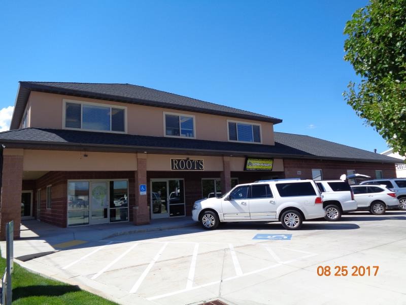
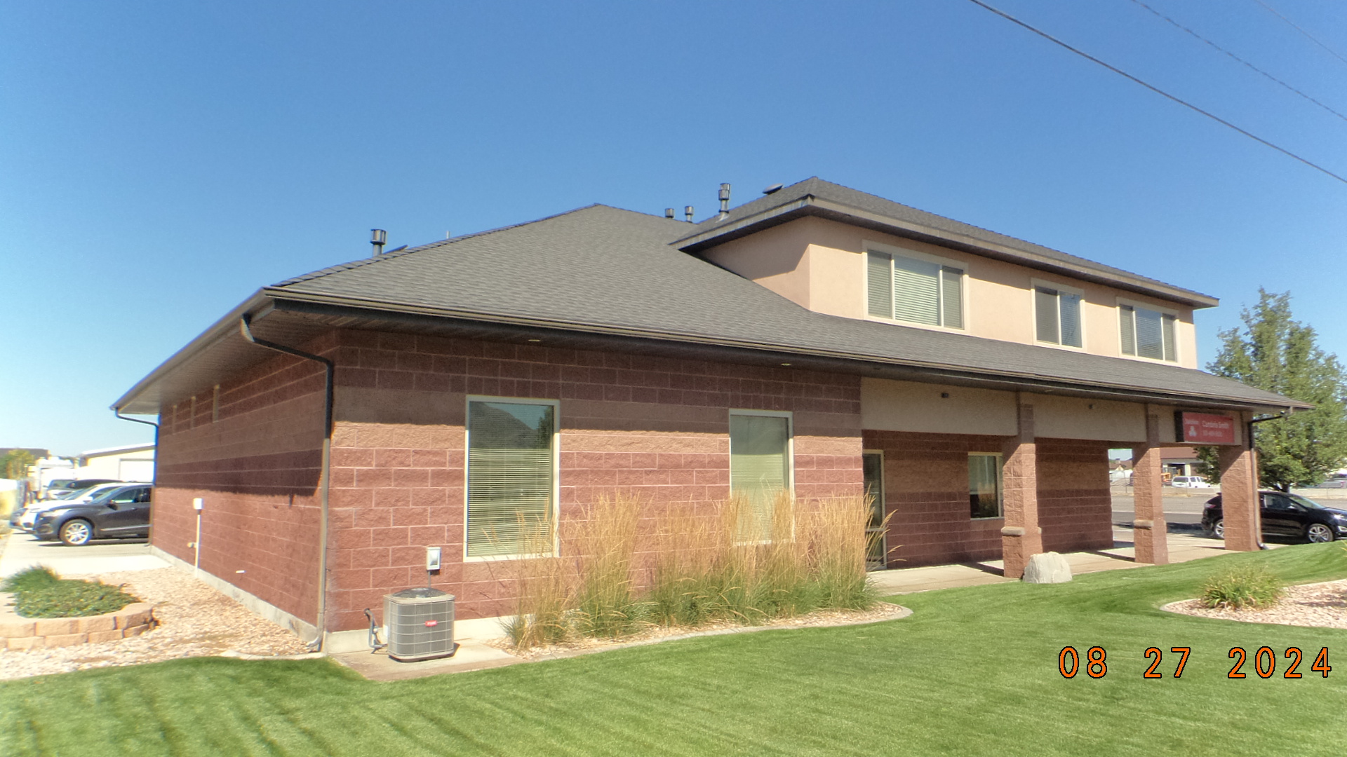 Total Photos: 8
|
| |
|
|
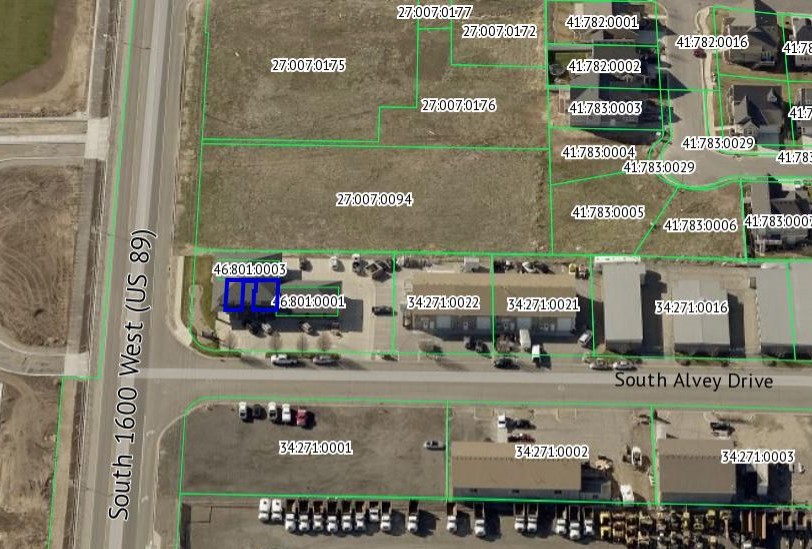
| Property Address: 1641 W ALVEY DR Unit# B - MAPLETON |
|
| Mailing Address: 5696 W CARSON DR HIGHLAND, UT 84003 |
|
| Acreage: 0.028688 |
|
| Last Document:
109763-2016
|
|
| Subdivision Map Filing |
|
| Taxing Description:
UNIT 2, PLAT A, MAPLE CREEK PROPERTIES CONDOS. AREA 0.029 AC.
*Taxing description NOT FOR LEGAL DOCUMENTS
|
|
- Owner Names
- Value History
- Tax History
- Location
- Photos
- Documents
- Aerial Image
| |
----- Real Estate Values ----- |
---Improvements--- |
---Greenbelt--- |
Total |
| Year |
Com |
Res |
Agr |
Tot |
Com |
Res |
Agr |
Tot |
Land |
Homesite |
Tot |
Market Value |
| 2024 |
$79,100 |
$0 |
$0 |
$79,100 |
$550,200 |
$0 |
$0 |
$550,200 |
$0 |
$0 |
$0 |
$629,300 |
| 2023 |
$77,500 |
$0 |
$0 |
$77,500 |
$539,500 |
$0 |
$0 |
$539,500 |
$0 |
$0 |
$0 |
$617,000 |
| 2022 |
$77,500 |
$0 |
$0 |
$77,500 |
$280,200 |
$0 |
$0 |
$280,200 |
$0 |
$0 |
$0 |
$357,700 |
| 2021 |
$77,500 |
$0 |
$0 |
$77,500 |
$280,200 |
$0 |
$0 |
$280,200 |
$0 |
$0 |
$0 |
$357,700 |
| 2020 |
$77,500 |
$0 |
$0 |
$77,500 |
$280,200 |
$0 |
$0 |
$280,200 |
$0 |
$0 |
$0 |
$357,700 |
| 2019 |
$66,500 |
$0 |
$0 |
$66,500 |
$291,200 |
$0 |
$0 |
$291,200 |
$0 |
$0 |
$0 |
$357,700 |
| 2018 |
$66,500 |
$0 |
$0 |
$66,500 |
$291,200 |
$0 |
$0 |
$291,200 |
$0 |
$0 |
$0 |
$357,700 |
| 2017 |
$55,400 |
$0 |
$0 |
$55,400 |
$241,700 |
$0 |
$0 |
$241,700 |
$0 |
$0 |
$0 |
$297,100 |
| 2016 |
$55,400 |
$0 |
$0 |
$55,400 |
$241,700 |
$0 |
$0 |
$241,700 |
$0 |
$0 |
$0 |
$297,100 |
| 2015 |
$55,400 |
$0 |
$0 |
$55,400 |
$241,700 |
$0 |
$0 |
$241,700 |
$0 |
$0 |
$0 |
$297,100 |
| 2014 |
$55,400 |
$0 |
$0 |
$55,400 |
$241,700 |
$0 |
$0 |
$241,700 |
$0 |
$0 |
$0 |
$297,100 |
| 2013 |
$55,400 |
$0 |
$0 |
$55,400 |
$241,700 |
$0 |
$0 |
$241,700 |
$0 |
$0 |
$0 |
$297,100 |
| 2012 |
$55,400 |
$0 |
$0 |
$55,400 |
$241,700 |
$0 |
$0 |
$241,700 |
$0 |
$0 |
$0 |
$297,100 |
| Year |
General Taxes |
Adjustments |
Net Taxes |
Fees |
Payments |
Tax Balance* |
Balance Due |
Tax District |
| 2025 |
$0.00 |
$0.00 |
$0.00 |
$0.00 |
|
$0.00
|
$0.00 |
140 - MAPLETON CITY |
| 2024 |
$6,423.89 |
$0.00 |
$6,423.89 |
$0.00 |
|
$0.00
|
$0.00 |
140 - MAPLETON CITY |
| 2023 |
$6,258.85 |
$0.00 |
$6,258.85 |
$0.00 |
|
$0.00
|
$0.00 |
140 - MAPLETON CITY |
| 2022 |
$3,669.64 |
$0.00 |
$3,669.64 |
$0.00 |
|
$0.00
|
$0.00 |
140 - MAPLETON CITY |
| 2021 |
$4,345.70 |
$0.00 |
$4,345.70 |
$0.00 |
|
$0.00
|
$0.00 |
140 - MAPLETON CITY |
| 2020 |
$4,492.71 |
$0.00 |
$4,492.71 |
$0.00 |
|
$0.00
|
$0.00 |
140 - MAPLETON CITY |
| 2019 |
$4,401.50 |
$0.00 |
$4,401.50 |
$0.00 |
|
$0.00
|
$0.00 |
140 - MAPLETON CITY |
| 2018 |
$4,623.63 |
$0.00 |
$4,623.63 |
$0.00 |
|
$0.00
|
$0.00 |
140 - MAPLETON CITY |
| 2017 |
$3,979.95 |
$0.00 |
$3,979.95 |
$0.00 |
|
$0.00
|
$0.00 |
140 - MAPLETON CITY |
| 2016 |
$4,003.72 |
$0.00 |
$4,003.72 |
$0.00 |
|
$0.00
|
$0.00 |
140 - MAPLETON CITY |
| 2015 |
$4,028.08 |
$0.00 |
$4,028.08 |
$0.00 |
|
$0.00
|
$0.00 |
140 - MAPLETON CITY |
| 2014 |
$4,101.76 |
$0.00 |
$4,101.76 |
$0.00 |
|
$0.00
|
$0.00 |
140 - MAPLETON CITY |
| 2013 |
$4,366.48 |
$0.00 |
$4,366.48 |
$0.00 |
|
$0.00
|
$0.00 |
140 - MAPLETON CITY |
| 2012 |
$4,466.30 |
$0.00 |
$4,466.30 |
$0.00 |
|
$0.00
|
$0.00 |
140 - MAPLETON CITY |
* Note: Original tax amount (Does not include applicable interest and/or fees).
| Entry # |
Date |
Recorded |
Type |
Party1 (Grantor) |
Party2 (Grantee) |
| 86020-2024 |
12/05/2024 |
12/06/2024 |
QCD |
BLEGGI FAMILY RENTALS LLC |
DME ENTERPRISES LLC |
| 109763-2016 |
07/06/2016 |
11/01/2016 |
WD |
MAPLE CREEK PROPERTIES INC |
BLEGGI FAMILY RENTALS LLC |
| 3187-2015 |
12/04/2014 |
01/14/2015 |
QCD |
UNITED STATES OF AMERICA |
SOUTH UTAH VALLEY ELECTRIC SERVICE DISTRICT |
| 30845-2011 |
04/21/2011 |
04/21/2011 |
WD |
BLEGGI FAMILY RENTALS LLC (ET AL) |
MAPLE CREEK PROPERTIES INC |
| 29318-2011 |
04/11/2011 |
04/15/2011 |
AFF SUR |
ANDREASON, BARRY SURV |
WHOM OF INTEREST |
| 6405-2011 |
01/07/2011 |
01/21/2011 |
DECLCON |
MAPLE CREEK PROPERTIES INC (ET AL) |
WHOM OF INTEREST |
| 6404-2011 |
01/05/2010 |
01/21/2011 |
C PLAT |
MAPLE CREEK PROPERTIES INC (ET AL) |
MAPLE CREEK PROPERTIES CONDOMINIUMS PLAT A |
Main Menu Comments or Concerns on Value/Appraisal - Assessor's Office
Documents/Owner/Parcel information - Recorder's Office
Address Change for Tax Notice
This page was created on 3/12/2025 11:58:11 AM |