Property Information
mobile view
| Serial Number: 49:318:0040 |
Serial Life: 1999... |
|
|
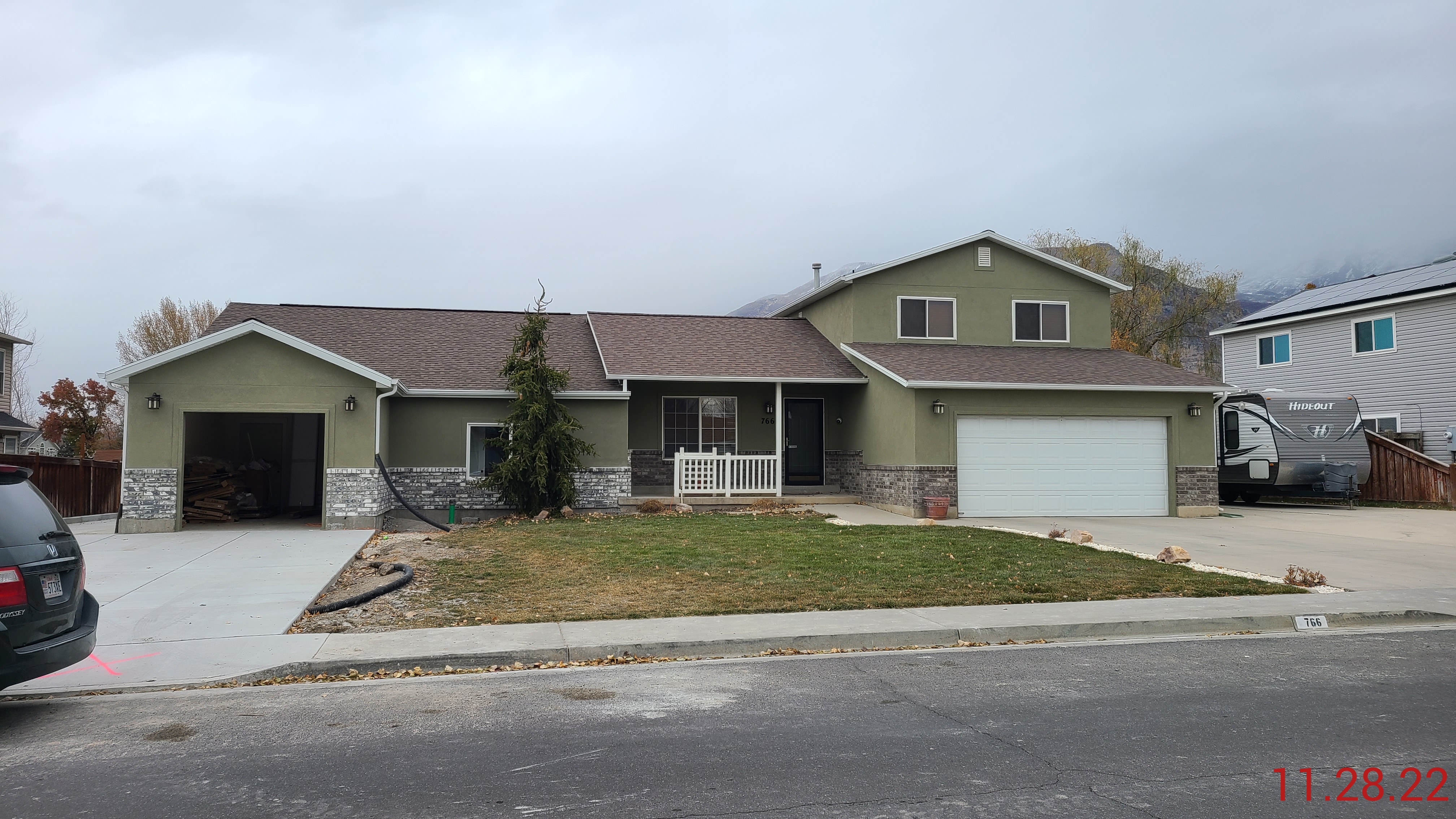 Total Photos: 4
|
| |
|
|
| Property Address: 766 W 425 NORTH - LINDON
more see "Addrs" tab below..
|
|
| Mailing Address: 766 W 425 N LINDON, UT 84042-1391 |
|
| Acreage: 0.472 |
|
| Last Document:
40166-1998
|
|
| Subdivision Map Filing |
|
| Taxing Description:
LOT 40, PLAT B, PHEASANT BROOK SUBDV. AREA 0.472 AC.
*Taxing description NOT FOR LEGAL DOCUMENTS
|
|
- Owner Names
- Value History
- Tax History
- Location
- Photos
- Documents
- Aerial Image
- Addrs
| |
----- Real Estate Values ----- |
---Improvements--- |
---Greenbelt--- |
Total |
| Year |
Com |
Res |
Agr |
Tot |
Com |
Res |
Agr |
Tot |
Land |
Homesite |
Tot |
Market Value |
| 2024 |
$0 |
$207,900 |
$0 |
$207,900 |
$0 |
$338,700 |
$0 |
$338,700 |
$0 |
$0 |
$0 |
$546,600 |
| 2023 |
$0 |
$189,000 |
$0 |
$189,000 |
$0 |
$340,600 |
$0 |
$340,600 |
$0 |
$0 |
$0 |
$529,600 |
| 2022 |
$0 |
$198,700 |
$0 |
$198,700 |
$0 |
$228,800 |
$0 |
$228,800 |
$0 |
$0 |
$0 |
$427,500 |
| 2021 |
$0 |
$141,900 |
$0 |
$141,900 |
$0 |
$181,600 |
$0 |
$181,600 |
$0 |
$0 |
$0 |
$323,500 |
| 2020 |
$0 |
$131,400 |
$0 |
$131,400 |
$0 |
$165,100 |
$0 |
$165,100 |
$0 |
$0 |
$0 |
$296,500 |
| 2019 |
$0 |
$131,400 |
$0 |
$131,400 |
$0 |
$143,600 |
$0 |
$143,600 |
$0 |
$0 |
$0 |
$275,000 |
| 2018 |
$0 |
$122,900 |
$0 |
$122,900 |
$0 |
$143,600 |
$0 |
$143,600 |
$0 |
$0 |
$0 |
$266,500 |
| 2017 |
$0 |
$110,200 |
$0 |
$110,200 |
$0 |
$143,600 |
$0 |
$143,600 |
$0 |
$0 |
$0 |
$253,800 |
| 2016 |
$0 |
$76,300 |
$0 |
$76,300 |
$0 |
$159,600 |
$0 |
$159,600 |
$0 |
$0 |
$0 |
$235,900 |
| 2015 |
$0 |
$76,300 |
$0 |
$76,300 |
$0 |
$139,400 |
$0 |
$139,400 |
$0 |
$0 |
$0 |
$215,700 |
| 2014 |
$0 |
$69,500 |
$0 |
$69,500 |
$0 |
$132,900 |
$0 |
$132,900 |
$0 |
$0 |
$0 |
$202,400 |
| 2013 |
$0 |
$63,900 |
$0 |
$63,900 |
$0 |
$115,600 |
$0 |
$115,600 |
$0 |
$0 |
$0 |
$179,500 |
| 2012 |
$0 |
$50,700 |
$0 |
$50,700 |
$0 |
$132,500 |
$0 |
$132,500 |
$0 |
$0 |
$0 |
$183,200 |
| 2011 |
$0 |
$50,700 |
$0 |
$50,700 |
$0 |
$134,600 |
$0 |
$134,600 |
$0 |
$0 |
$0 |
$185,300 |
| 2010 |
$0 |
$60,000 |
$0 |
$60,000 |
$0 |
$145,234 |
$0 |
$145,234 |
$0 |
$0 |
$0 |
$205,234 |
| 2009 |
$0 |
$104,400 |
$0 |
$104,400 |
$0 |
$114,200 |
$0 |
$114,200 |
$0 |
$0 |
$0 |
$218,600 |
| 2008 |
$0 |
$126,700 |
$0 |
$126,700 |
$0 |
$115,100 |
$0 |
$115,100 |
$0 |
$0 |
$0 |
$241,800 |
| 2007 |
$0 |
$83,800 |
$0 |
$83,800 |
$0 |
$158,000 |
$0 |
$158,000 |
$0 |
$0 |
$0 |
$241,800 |
| 2006 |
$0 |
$83,800 |
$0 |
$83,800 |
$0 |
$93,700 |
$0 |
$93,700 |
$0 |
$0 |
$0 |
$177,500 |
| 2005 |
$0 |
$54,410 |
$0 |
$54,410 |
$0 |
$91,880 |
$0 |
$91,880 |
$0 |
$0 |
$0 |
$146,290 |
| 2004 |
$0 |
$54,410 |
$0 |
$54,410 |
$0 |
$91,880 |
$0 |
$91,880 |
$0 |
$0 |
$0 |
$146,290 |
| 2003 |
$0 |
$54,410 |
$0 |
$54,410 |
$0 |
$91,880 |
$0 |
$91,880 |
$0 |
$0 |
$0 |
$146,290 |
| 2002 |
$0 |
$54,410 |
$0 |
$54,410 |
$0 |
$91,880 |
$0 |
$91,880 |
$0 |
$0 |
$0 |
$146,290 |
| 2001 |
$0 |
$54,410 |
$0 |
$54,410 |
$0 |
$91,880 |
$0 |
$91,880 |
$0 |
$0 |
$0 |
$146,290 |
| 2000 |
$0 |
$50,850 |
$0 |
$50,850 |
$0 |
$80,959 |
$0 |
$80,959 |
$0 |
$0 |
$0 |
$131,809 |
| 1999 |
$0 |
$50,850 |
$0 |
$50,850 |
$0 |
$80,959 |
$0 |
$80,959 |
$0 |
$0 |
$0 |
$131,809 |
| Year |
General Taxes |
Adjustments |
Net Taxes |
Fees |
Payments |
Tax Balance* |
Balance Due |
Tax District |
| 2025 |
$0.00 |
$0.00 |
$0.00 |
$0.00 |
|
$0.00
|
$0.00 |
080 - LINDON CITY |
| 2024 |
$2,438.71 |
$0.00 |
$2,438.71 |
$0.00 |
|
$0.00
|
$0.00 |
080 - LINDON CITY |
| 2023 |
$2,199.75 |
$0.00 |
$2,199.75 |
$0.00 |
|
$0.00
|
$0.00 |
080 - LINDON CITY |
| 2022 |
$1,838.21 |
$0.00 |
$1,838.21 |
$0.00 |
|
$0.00
|
$0.00 |
080 - LINDON CITY |
| 2021 |
$1,677.30 |
$0.00 |
$1,677.30 |
$0.00 |
|
$0.00
|
$0.00 |
080 - LINDON CITY |
| 2020 |
$1,561.61 |
$0.00 |
$1,561.61 |
$0.00 |
|
$0.00
|
$0.00 |
080 - LINDON CITY |
| 2019 |
$1,388.32 |
$0.00 |
$1,388.32 |
$0.00 |
|
$0.00
|
$0.00 |
080 - LINDON CITY |
| 2018 |
$1,427.05 |
$0.00 |
$1,427.05 |
$0.00 |
|
$0.00
|
$0.00 |
080 - LINDON CITY |
| 2017 |
$1,394.09 |
$0.00 |
$1,394.09 |
$0.00 |
|
$0.00
|
$0.00 |
080 - LINDON CITY |
| 2016 |
$1,400.86 |
$0.00 |
$1,400.86 |
$0.00 |
|
$0.00
|
$0.00 |
080 - LINDON CITY |
| 2015 |
$1,354.93 |
$0.00 |
$1,354.93 |
$0.00 |
|
$0.00
|
$0.00 |
080 - LINDON CITY |
| 2014 |
$1,283.41 |
$0.00 |
$1,283.41 |
$0.00 |
|
$0.00
|
$0.00 |
080 - LINDON CITY |
| 2013 |
$1,228.83 |
$0.00 |
$1,228.83 |
$0.00 |
|
$0.00
|
$0.00 |
080 - LINDON CITY |
| 2012 |
$1,281.06 |
$0.00 |
$1,281.06 |
$0.00 |
|
$0.00
|
$0.00 |
080 - LINDON CITY |
| 2011 |
$1,291.26 |
$0.00 |
$1,291.26 |
$0.00 |
|
$0.00
|
$0.00 |
080 - LINDON CITY |
| 2010 |
$1,332.88 |
$0.00 |
$1,332.88 |
$0.00 |
|
$0.00
|
$0.00 |
080 - LINDON CITY |
| 2009 |
$1,302.09 |
$0.00 |
$1,302.09 |
$0.00 |
|
$0.00
|
$0.00 |
080 - LINDON CITY |
| 2008 |
$1,295.85 |
$0.00 |
$1,295.85 |
$0.00 |
|
$0.00
|
$0.00 |
080 - LINDON CITY |
| 2007 |
$1,280.56 |
$0.00 |
$1,280.56 |
$0.00 |
|
$0.00
|
$0.00 |
080 - LINDON CITY |
| 2006 |
$996.17 |
$0.00 |
$996.17 |
$0.00 |
|
$0.00
|
$0.00 |
080 - LINDON CITY |
| 2005 |
$944.20 |
$0.00 |
$944.20 |
$0.00 |
|
$0.00
|
$0.00 |
080 - LINDON CITY |
| 2004 |
$944.12 |
$0.00 |
$944.12 |
$0.00 |
|
$0.00
|
$0.00 |
080 - LINDON CITY |
| 2003 |
$927.46 |
$0.00 |
$927.46 |
$0.00 |
|
$0.00
|
$0.00 |
080 - LINDON CITY |
| 2002 |
$850.70 |
$0.00 |
$850.70 |
$0.00 |
|
$0.00
|
$0.00 |
080 - LINDON CITY |
| 2001 |
$849.66 |
$0.00 |
$849.66 |
$0.00 |
|
$0.00
|
$0.00 |
080 - LINDON CITY |
| 2000 |
$790.99 |
$0.00 |
$790.99 |
$0.00 |
|
$0.00
|
$0.00 |
080 - LINDON CITY |
| 1999 |
$808.68 |
$0.00 |
$808.68 |
$0.00 |
|
$0.00
|
$0.00 |
080 - LINDON CITY |
* Note: Original tax amount (Does not include applicable interest and/or fees).
| Entry # |
Date |
Recorded |
Type |
Party1 (Grantor) |
Party2 (Grantee) |
| 79711-2022 |
|
07/12/2022 |
N |
LINDON CITY |
WHOM OF INTEREST |
| 56681-2022 |
05/04/2022 |
05/09/2022 |
RSUBTEE |
MORTGAGE ELECTRONIC REGISTRATION SYSTEMS INC (ET AL) |
CARTER, PEGGY E |
| 52781-2022 |
04/26/2022 |
04/28/2022 |
D TR |
CARTER, JEFFREY |
UTAH COMMUNITY FEDERAL CREDIT UNION |
| 52780-2022 |
04/26/2022 |
04/28/2022 |
WD |
CARTER, PEGGY EILEEN ENGLAND |
CARTER, JEFFREY |
| 50958-2022 |
04/25/2022 |
04/25/2022 |
SP WD |
CARTER, PEGGY EILEEN ENGLAND TEE (ET AL) |
CARTER, PEGGY EILEEN ENGLAND |
| 34108-2021 |
02/11/2021 |
02/23/2021 |
QCD |
CARTER, PEGGY E |
CARTER, PEGGY EILEEN ENGLAND TEE (ET AL) |
| 68100-2011 |
09/21/2011 |
09/27/2011 |
REC |
FIRST AMERICAN TITLE INSURANCE COMPANY TEE |
CARTER, PEGGY E |
| 68099-2011 |
09/19/2011 |
09/27/2011 |
SUB TEE |
MORTGAGE ELECTRONIC REGISTRATION SYSTEMS INC |
FIRST AMERICAN TITLE INSURANCE COMPANY SUCTEE |
| 62567-2011 |
08/30/2011 |
09/06/2011 |
D TR |
CARTER, PEGGY E |
UTAH COMMUNITY FEDERAL CREDIT UNION |
| 114631-2009 |
10/30/2009 |
11/03/2009 |
REC |
UTAH COMMERCIAL TITLE |
WHOM OF INTEREST |
| 51465-2009 |
04/24/2009 |
05/11/2009 |
REC |
FAR WEST BANK TEE |
JENSEN, JOEL A & SANDRA LEE |
| 34640-2009 |
03/26/2009 |
04/02/2009 |
D TR |
CARTER, PEGGY E |
CASTLE & COOKE MORTGAGE LLC DBA (ET AL) |
| 154162-2007 |
10/10/2007 |
10/29/2007 |
REC |
LUNDBERG, J SCOTT TEE |
JENSEN, JOEL A & SANDRA L |
| 154161-2007 |
09/27/2007 |
10/29/2007 |
SUB TEE |
MORTGAGE ELECTRONIC REGISTRATION SYSTEMS INC |
LUNDBERG, J SCOTT SUCTEE |
| 103956-2007 |
07/17/2007 |
07/18/2007 |
WD |
JENSEN, JOEL A & SANDRA LEE |
CARTER, PEGGY E |
| 7879-2007 |
01/04/2007 |
01/17/2007 |
REC |
BANK OF AMERICAN FORK TEE |
JENSEN, JOEL A & SANDRA L |
| 27091-2006 |
02/24/2006 |
03/07/2006 |
RC |
BANK OF AMERICAN FORK |
WHOM OF INTEREST |
| 25690-2006 |
02/24/2006 |
03/03/2006 |
D TR |
JENSEN, JOEL A & SANDRA L |
BANK OF AMERICAN FORK |
| 88576-2005 |
08/11/2005 |
08/12/2005 |
RC |
FAR WEST BANK |
WHOM OF INTEREST |
| 88575-2005 |
08/08/2005 |
08/12/2005 |
D TR |
JENSEN, SANDRA LEE & JOEL A |
FAR WEST BANK |
| 197129-2003 |
12/12/2003 |
12/16/2003 |
QCD |
SALISBURY DEVELOPMENT LC |
MAXFIELD, GWENLA ANDERSON |
| 136640-2003 |
07/25/2003 |
08/21/2003 |
REC |
WELLS FARGO FINANCIAL NATIONAL BANK TEE |
JENSEN, JOEL A & SANDRA L |
| 136639-2003 |
07/31/2003 |
08/21/2003 |
SUB TEE |
FIRST NATIONAL BANK OF CHICAGO TEE |
WELLS FARGO FINANCIAL NATIONAL BANK SUCTEE |
| 81305-2003 |
05/23/2003 |
05/30/2003 |
D TR |
JENSEN, JOEL A & SANDRA L |
FIRST COLONY MORTGAGE CORPORATION |
| 121167-1999 |
10/19/1998 |
11/17/1999 |
AS |
FIRST SECURITY BANK |
FIRST NATIONAL BANK OF CHICAGO THE TEE |
| 116312-1999 |
09/30/1998 |
11/02/1999 |
AS |
FIRST SECURITY BANK |
FIRST NATIONAL BANK OF CHICAGO THE TEE |
| 35005-1999 |
03/24/1999 |
03/25/1999 |
REC |
PROVO LAND TITLE COMPANY TEE |
SALISBURY DEVELOPMENT LC |
| 92615-1998 |
09/10/1998 |
09/11/1998 |
REC |
PROVO LAND TITLE COMPANY TEE |
JENSEN, JOEL A & SANDRA LEE |
| 55635-1998 |
06/02/1998 |
06/03/1998 |
REC |
PROVO LAND TITLE COMPANY TEE |
JENSEN, JOEL A & SANDRA LEE |
| 51139-1998 |
05/19/1998 |
05/21/1998 |
REC |
PROVO LAND TITLE COMPANY TEE |
SALISBURY DEVELOPMENT LC |
| 43440-1998 |
04/29/1998 |
05/01/1998 |
MOD AGR |
SALISBURY DEVELOPMENT LC |
FIRST SECURITY BANK |
| 41785-1998 |
04/24/1998 |
04/28/1998 |
D TR |
JENSEN, JOEL A & SANDRA L |
FIRST SECURITY BANK |
| 40167-1998 |
04/23/1998 |
04/24/1998 |
TR D |
JENSEN, JOEL A & SADRA LEE |
SALISBURY DEVELOPMENT LC |
| 40166-1998 |
04/23/1998 |
04/24/1998 |
WD |
SALISBURY DEVELOPMENT LC |
JENSEN, JOEL A & SANDRA LEE |
| 21516-1998 |
03/03/1998 |
03/06/1998 |
D TR |
SALISBURY DEVELOPMENT LC |
FIRST SECURITY BANK |
| 16502-1998 |
01/07/1998 |
02/23/1998 |
S PLAT |
SALISBURY DEVELOPMENT LC |
PHEASANT BROOK PLAT B |
766 W 425 NORTH - LINDON
768 W 425 NORTH - LINDON
Main Menu Comments or Concerns on Value/Appraisal - Assessor's Office
Documents/Owner/Parcel information - Recorder's Office
Address Change for Tax Notice
This page was created on 3/4/2025 9:09:00 AM |


