Property Information
mobile view
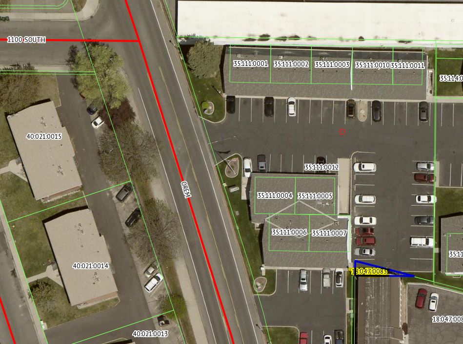
| Serial Number: 18:047:0083 |
Serial Life: 2009... |
|
|
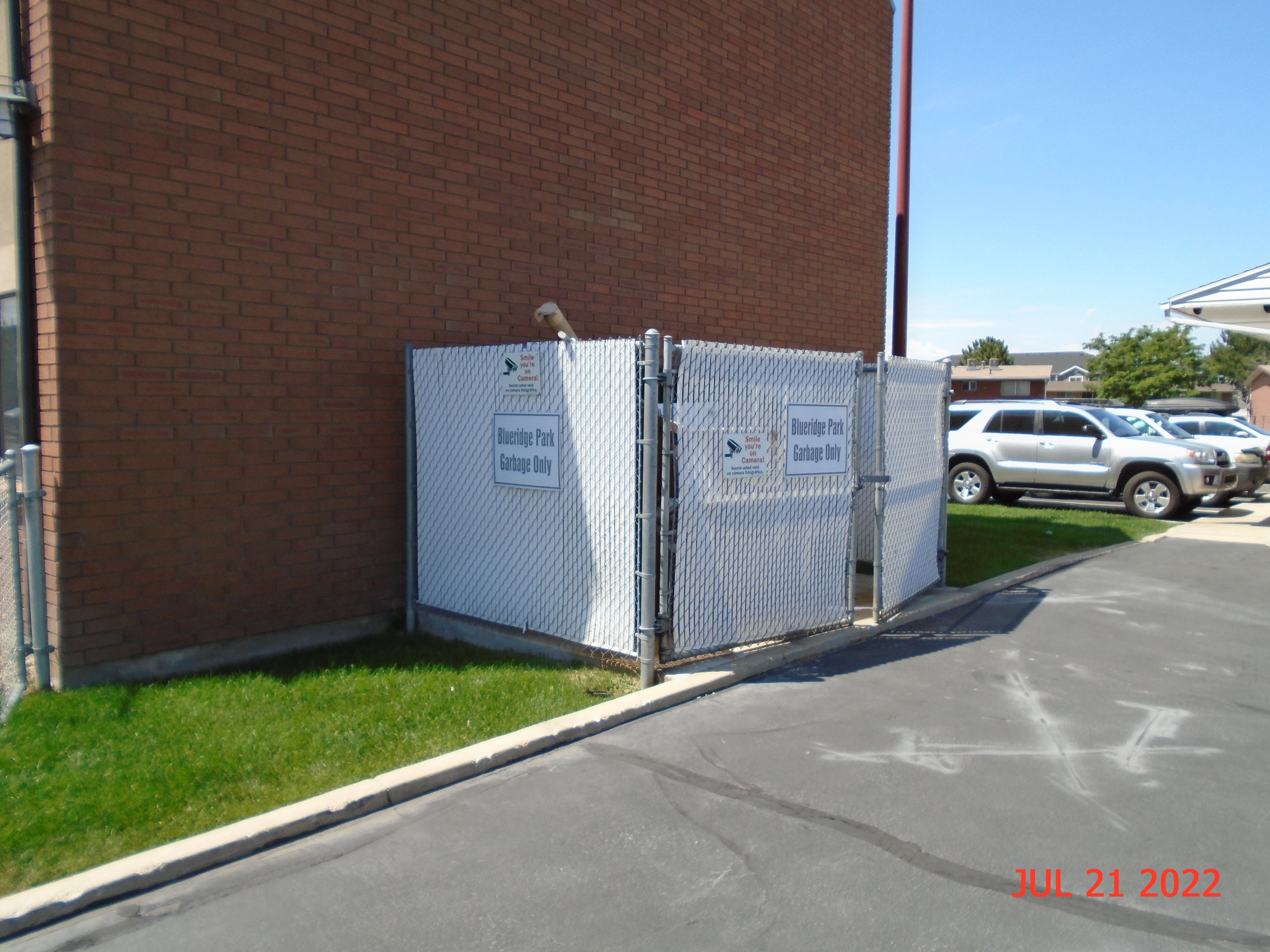 Total Photos: 4
|
| |
|
|
| Property Address: OREM |
|
| Mailing Address: 1142 S 400 E SALEM, UT 84653-5015 |
|
| Acreage: 0.005752 |
|
| Last Document:
37985-2008
|
|
| Subdivision Map Filing |
|
| Taxing Description:
COM N 89 DEG 24' 38" W 637.21 FT & N 486.05 FT FR S 1/4 COR. SEC. 23, T6S, R2E, SLB&M.; N 89 DEG 16' 43" W 45.19 FT; N 0 DEG 44' 7" E 11.09 FT; S 75 DEG 29' 16" E 46.53 FT TO BEG. AREA 0.006 AC.
*Taxing description NOT FOR LEGAL DOCUMENTS
|
|
- Owner Names
- Value History
- Tax History
- Location
- Photos
- Documents
- Aerial Image
| |
----- Real Estate Values ----- |
---Improvements--- |
---Greenbelt--- |
Total |
| Year |
Com |
Res |
Agr |
Tot |
Com |
Res |
Agr |
Tot |
Land |
Homesite |
Tot |
Market Value |
| 2024 |
$4,900 |
$0 |
$0 |
$4,900 |
$0 |
$0 |
$0 |
$0 |
$0 |
$0 |
$0 |
$4,900 |
| 2023 |
$4,400 |
$0 |
$0 |
$4,400 |
$0 |
$0 |
$0 |
$0 |
$0 |
$0 |
$0 |
$4,400 |
| 2022 |
$4,400 |
$0 |
$0 |
$4,400 |
$0 |
$0 |
$0 |
$0 |
$0 |
$0 |
$0 |
$4,400 |
| 2021 |
$1,900 |
$0 |
$0 |
$1,900 |
$0 |
$0 |
$0 |
$0 |
$0 |
$0 |
$0 |
$1,900 |
| 2020 |
$1,800 |
$0 |
$0 |
$1,800 |
$0 |
$0 |
$0 |
$0 |
$0 |
$0 |
$0 |
$1,800 |
| 2019 |
$1,800 |
$0 |
$0 |
$1,800 |
$0 |
$0 |
$0 |
$0 |
$0 |
$0 |
$0 |
$1,800 |
| 2018 |
$1,700 |
$0 |
$0 |
$1,700 |
$0 |
$0 |
$0 |
$0 |
$0 |
$0 |
$0 |
$1,700 |
| 2017 |
$1,600 |
$0 |
$0 |
$1,600 |
$0 |
$0 |
$0 |
$0 |
$0 |
$0 |
$0 |
$1,600 |
| 2016 |
$1,600 |
$0 |
$0 |
$1,600 |
$0 |
$0 |
$0 |
$0 |
$0 |
$0 |
$0 |
$1,600 |
| 2015 |
$1,500 |
$0 |
$0 |
$1,500 |
$0 |
$0 |
$0 |
$0 |
$0 |
$0 |
$0 |
$1,500 |
| 2014 |
$500 |
$0 |
$0 |
$500 |
$0 |
$0 |
$0 |
$0 |
$0 |
$0 |
$0 |
$500 |
| 2013 |
$500 |
$0 |
$0 |
$500 |
$0 |
$0 |
$0 |
$0 |
$0 |
$0 |
$0 |
$500 |
| 2012 |
$500 |
$0 |
$0 |
$500 |
$0 |
$0 |
$0 |
$0 |
$0 |
$0 |
$0 |
$500 |
| 2011 |
$500 |
$0 |
$0 |
$500 |
$0 |
$0 |
$0 |
$0 |
$0 |
$0 |
$0 |
$500 |
| 2010 |
$500 |
$0 |
$0 |
$500 |
$0 |
$0 |
$0 |
$0 |
$0 |
$0 |
$0 |
$500 |
| 2009 |
$500 |
$0 |
$0 |
$500 |
$0 |
$0 |
$0 |
$0 |
$0 |
$0 |
$0 |
$500 |
| Year |
General Taxes |
Adjustments |
Net Taxes |
Fees |
Payments |
Tax Balance* |
Balance Due |
Tax District |
| 2025 |
$0.00 |
$0.00 |
$0.00 |
$0.00 |
|
$0.00
|
$0.00 |
090 - OREM CITY |
| 2024 |
$40.07 |
$0.00 |
$40.07 |
$0.00 |
|
$0.00
|
$0.00 |
090 - OREM CITY |
| 2023 |
$33.48 |
$0.00 |
$33.48 |
$0.00 |
|
$0.00
|
$0.00 |
090 - OREM CITY |
| 2022 |
$34.56 |
$0.00 |
$34.56 |
$0.00 |
|
$0.00
|
$0.00 |
090 - OREM CITY |
| 2021 |
$17.91 |
$0.00 |
$17.91 |
$0.00 |
|
$0.00
|
$0.00 |
090 - OREM CITY |
| 2020 |
$17.27 |
$0.00 |
$17.27 |
$0.00 |
|
$0.00
|
$0.00 |
090 - OREM CITY |
| 2019 |
$16.61 |
$0.00 |
$16.61 |
$0.00 |
|
$0.00
|
$0.00 |
090 - OREM CITY |
| 2018 |
$16.41 |
$0.00 |
$16.41 |
$0.00 |
|
$0.00
|
$0.00 |
090 - OREM CITY |
| 2017 |
$15.86 |
$0.00 |
$15.86 |
$0.00 |
|
$0.00
|
$0.00 |
090 - OREM CITY |
| 2016 |
$17.20 |
$0.00 |
$17.20 |
$0.00 |
|
$0.00
|
$0.00 |
090 - OREM CITY |
| 2015 |
$17.05 |
$0.00 |
$17.05 |
$0.00 |
|
$0.00
|
$0.00 |
090 - OREM CITY |
| 2014 |
$5.71 |
$0.00 |
$5.71 |
$0.00 |
|
$0.00
|
$0.00 |
090 - OREM CITY |
| 2013 |
$6.16 |
$0.00 |
$6.16 |
$0.00 |
|
$0.00
|
$0.00 |
090 - OREM CITY |
| 2012 |
$6.28 |
$0.00 |
$6.28 |
$0.00 |
|
$0.00
|
$0.00 |
090 - OREM CITY |
| 2011 |
$6.25 |
$0.00 |
$6.25 |
$0.00 |
|
$0.00
|
$0.00 |
090 - OREM CITY |
| 2010 |
$5.86 |
$0.00 |
$5.86 |
$0.00 |
|
$0.00
|
$0.00 |
090 - OREM CITY |
| 2009 |
$5.43 |
$0.00 |
$5.43 |
$0.00 |
|
$0.00
|
$0.00 |
090 - OREM CITY |
* Note: Original tax amount (Does not include applicable interest and/or fees).
| Entry # |
Date |
Recorded |
Type |
Party1 (Grantor) |
Party2 (Grantee) |
| 50742-2023 |
08/02/2023 |
08/03/2023 |
TD |
UTAH COUNTY |
ROUNDY, BRADY R |
| 47574-2008 |
04/22/2008 |
04/22/2008 |
WD |
GAPPMAYER, MERRILL & MARIE TEE (ET AL) |
BLUE RIDGE PARK OFFICE CONDOMINUM OWNER'S ASSOCIATION |
| 37985-2008 |
03/18/2008 |
04/01/2008 |
BLA |
GAPPMAYER, MERRILL & MARIE TEE (ET AL) |
DODGE, S MARTIN |
Main Menu Comments or Concerns on Value/Appraisal - Assessor's Office
Documents/Owner/Parcel information - Recorder's Office
Address Change for Tax Notice
This page was created on 1/3/2025 4:26:12 AM |