Property Information
mobile view
| Serial Number: 18:056:0049 |
Serial Life: 1980-2001 |
|
|
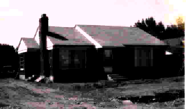 Total Photos: 1
|
| |
|
|
| Property Address: OREM |
|
| Mailing Address: UNIVERSITY MALL E 205 OREM, UT 84097 |
|
| Acreage: 0.21 |
|
| Last Document:
14697-1985
|
|
| Subdivision Map Filing |
|
| Taxing Description:
COM AT A PT ON S SIDE OF 800 S ST & ON W SIDE OF 700 E ST, N 89 18'W 683.42 FT & S 29'W 123 FT FR E1/4 COR SEC 23, T6S, R2E, SLM; S 29'W ALONG W LINE OF 700 E ST 78.96 FT; N 89 18' W & PARALLEL TO 800 S ST 118 FT; N 29'E & APRALLEL TO 700 E ST 82.02 FT; S 89 18'E 118 FT TO BEG. AREA .21 OF AN ACRE.
*Taxing description NOT FOR LEGAL DOCUMENTS
|
|
- Owner Names
- Value History
- Tax History
- Location
- Photos
- Documents
- Aerial Image
| |
----- Real Estate Values ----- |
---Improvements--- |
---Greenbelt--- |
Total |
| Year |
Com |
Res |
Agr |
Tot |
Com |
Res |
Agr |
Tot |
Land |
Homesite |
Tot |
Market Value |
| 2001 |
$60,000 |
$0 |
$0 |
$60,000 |
$0 |
$0 |
$0 |
$0 |
$0 |
$0 |
$0 |
$60,000 |
| 2000 |
$60,000 |
$0 |
$0 |
$60,000 |
$0 |
$0 |
$0 |
$0 |
$0 |
$0 |
$0 |
$60,000 |
| 1999 |
$0 |
$52,373 |
$0 |
$52,373 |
$0 |
$48,732 |
$0 |
$48,732 |
$0 |
$0 |
$0 |
$101,105 |
| 1998 |
$0 |
$52,373 |
$0 |
$52,373 |
$0 |
$48,732 |
$0 |
$48,732 |
$0 |
$0 |
$0 |
$101,105 |
| 1997 |
$0 |
$52,373 |
$0 |
$52,373 |
$0 |
$48,732 |
$0 |
$48,732 |
$0 |
$0 |
$0 |
$101,105 |
| 1996 |
$0 |
$43,123 |
$0 |
$43,123 |
$0 |
$40,125 |
$0 |
$40,125 |
$0 |
$0 |
$0 |
$83,248 |
| 1995 |
$0 |
$39,203 |
$0 |
$39,203 |
$0 |
$40,125 |
$0 |
$40,125 |
$0 |
$0 |
$0 |
$79,328 |
| 1994 |
$0 |
$22,926 |
$0 |
$22,926 |
$0 |
$32,359 |
$0 |
$32,359 |
$0 |
$0 |
$0 |
$55,285 |
| 1993 |
$0 |
$22,926 |
$0 |
$22,926 |
$0 |
$32,359 |
$0 |
$32,359 |
$0 |
$0 |
$0 |
$55,285 |
| 1992 |
$0 |
$21,033 |
$0 |
$21,033 |
$0 |
$29,687 |
$0 |
$29,687 |
$0 |
$0 |
$0 |
$50,720 |
| 1991 |
$0 |
$18,450 |
$0 |
$18,450 |
$0 |
$24,607 |
$0 |
$24,607 |
$0 |
$0 |
$0 |
$43,057 |
| 1990 |
$0 |
$18,450 |
$0 |
$18,450 |
$0 |
$24,607 |
$0 |
$24,607 |
$0 |
$0 |
$0 |
$43,057 |
| 1989 |
$0 |
$18,450 |
$0 |
$18,450 |
$0 |
$24,607 |
$0 |
$24,607 |
$0 |
$0 |
$0 |
$43,057 |
| 1988 |
$0 |
$18,450 |
$0 |
$18,450 |
$0 |
$28,258 |
$0 |
$28,258 |
$0 |
$0 |
$0 |
$46,708 |
| 1987 |
$0 |
$18,450 |
$0 |
$18,450 |
$0 |
$36,208 |
$0 |
$36,208 |
$0 |
$0 |
$0 |
$54,658 |
| 1986 |
$0 |
$18,450 |
$0 |
$18,450 |
$0 |
$36,209 |
$0 |
$36,209 |
$0 |
$0 |
$0 |
$54,659 |
| 1985 |
$0 |
$18,450 |
$0 |
$18,450 |
$0 |
$36,208 |
$0 |
$36,208 |
$0 |
$0 |
$0 |
$54,658 |
| 1984 |
$0 |
$18,633 |
$0 |
$18,633 |
$0 |
$36,575 |
$0 |
$36,575 |
$0 |
$0 |
$0 |
$55,208 |
| Year |
General Taxes |
Adjustments |
Net Taxes |
Fees |
Payments |
Tax Balance* |
Balance Due |
Tax District |
| 2001 |
$618.66 |
$0.00 |
$618.66 |
$0.00 |
|
$0.00
|
$0.00 |
090 - OREM CITY |
| 2000 |
$639.66 |
$0.00 |
$639.66 |
$0.00 |
|
$0.00
|
$0.00 |
090 - OREM CITY |
| 1999 |
$610.35 |
$0.00 |
$610.35 |
$0.00 |
|
$0.00
|
$0.00 |
090 - OREM CITY |
| 1998 |
$576.32 |
$0.00 |
$576.32 |
$0.00 |
|
$0.00
|
$0.00 |
090 - OREM CITY |
| 1997 |
$573.93 |
$0.00 |
$573.93 |
$0.00 |
|
$0.00
|
$0.00 |
090 - OREM CITY |
| 1996 |
$431.73 |
$0.00 |
$431.73 |
$0.00 |
|
$0.00
|
$0.00 |
090 - OREM CITY |
| 1995 |
$465.54 |
$0.00 |
$465.54 |
$0.00 |
|
$0.00
|
$0.00 |
090 - OREM CITY |
| 1994 |
$516.92 |
$0.00 |
$516.92 |
$0.00 |
|
$0.00
|
$0.00 |
090 - OREM CITY |
| 1993 |
$457.47 |
$0.00 |
$457.47 |
$0.00 |
|
$0.00
|
$0.00 |
090 - OREM CITY |
| 1992 |
$423.15 |
$0.00 |
$423.15 |
$0.00 |
|
$0.00
|
$0.00 |
090 - OREM CITY |
| 1991 |
$375.57 |
$0.00 |
$375.57 |
$0.00 |
|
$0.00
|
$0.00 |
090 - OREM CITY |
| 1990 |
$361.03 |
$0.00 |
$361.03 |
$0.00 |
|
$0.00
|
$0.00 |
090 - OREM CITY |
| 1989 |
$367.95 |
$0.00 |
$367.95 |
$0.00 |
|
$0.00
|
$0.00 |
090 - OREM CITY |
| 1988 |
$398.21 |
$0.00 |
$398.21 |
$0.00 |
|
$0.00
|
$0.00 |
090 - OREM CITY |
| 1987 |
$458.28 |
$0.00 |
$458.28 |
$0.00 |
|
$0.00
|
$0.00 |
090 - OREM CITY |
| 1986 |
$452.11 |
$0.00 |
$452.11 |
$0.00 |
|
$0.00
|
$0.00 |
090 - OREM CITY |
| 1985 |
$454.80 |
$0.00 |
$454.80 |
$0.00 |
|
$0.00
|
$0.00 |
090 - OREM CITY |
| 1984 |
$450.57 |
$0.00 |
$450.57 |
$0.00 |
|
$0.00
|
$0.00 |
090 - OREM CITY |
* Note: Original tax amount (Does not include applicable interest and/or fees).
| Entry # |
Date |
Recorded |
Type |
Party1 (Grantor) |
Party2 (Grantee) |
| 19427-2001 |
03/01/2001 |
03/01/2001 |
S PLAT |
UNIVERSITY MALL INC (ET AL) |
UNIVERSITY MALL PLAT A |
| 125429-1999 |
11/04/1999 |
12/01/1999 |
MEM LS |
COSTCO WHOLESALE CORPORATION |
UNIVERSITY MALL SHOPPING CENTER |
| 14697-1985 |
05/23/1985 |
05/24/1985 |
WD |
COWAN AFTON L REVOCABLE TRUST THE BY (ET AL) |
UNIVERSITY MALL SHOPPING CENTER |
Main Menu Comments or Concerns on Value/Appraisal - Assessor's Office
Documents/Owner/Parcel information - Recorder's Office
Address Change for Tax Notice
This page was created on 1/30/2025 11:57:43 AM |