Property Information
mobile view
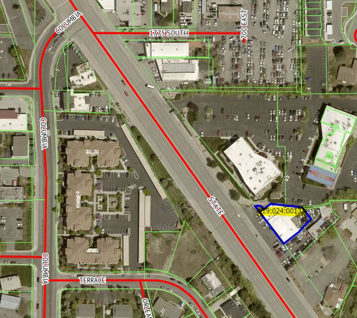
| Serial Number: 19:024:0013 |
Serial Life: 1981... |
|
|
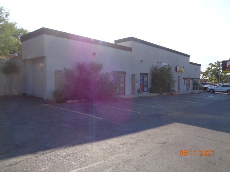
 Total Photos: 9
|
| |
|
|
| Property Address: 1985 S STATE - OREM |
|
| Mailing Address: 145 W 7200 S STE A MIDVALE, UT 84047 |
|
| Acreage: 0.25 |
|
| Last Document:
37618-2010
|
|
| Subdivision Map Filing |
|
| Taxing Description:
COM N 985.87 FT & W 683.78 FT FR SE COR SEC 26, T6S, R2E, SLM; N 89 DEG 03'13"E 17.10 FT; S 39 DEG 43'24"E 14.66 FT; N 50 DEG 25'09"E 26.43 FT; S 83 DEG 39'21"E 94.57 FT; S 38 DEG 16'47"E 44 FT; S 42 DEG 55'W 53.65 FT; S 53 DEG 05'41"W 58.10 FT; N 36 DEG 54'19"W 141.72 FT TO BEG. AREA .25 ACRE.
*Taxing description NOT FOR LEGAL DOCUMENTS
|
|
- Owner Names
- Value History
- Tax History
- Location
- Photos
- Documents
- Aerial Image
| |
----- Real Estate Values ----- |
---Improvements--- |
---Greenbelt--- |
Total |
| Year |
Com |
Res |
Agr |
Tot |
Com |
Res |
Agr |
Tot |
Land |
Homesite |
Tot |
Market Value |
| 2024 |
$172,600 |
$0 |
$0 |
$172,600 |
$526,300 |
$0 |
$0 |
$526,300 |
$0 |
$0 |
$0 |
$698,900 |
| 2023 |
$174,300 |
$0 |
$0 |
$174,300 |
$497,000 |
$0 |
$0 |
$497,000 |
$0 |
$0 |
$0 |
$671,300 |
| 2022 |
$173,000 |
$0 |
$0 |
$173,000 |
$485,500 |
$0 |
$0 |
$485,500 |
$0 |
$0 |
$0 |
$658,500 |
| 2021 |
$173,300 |
$0 |
$0 |
$173,300 |
$332,500 |
$0 |
$0 |
$332,500 |
$0 |
$0 |
$0 |
$505,800 |
| 2020 |
$173,300 |
$0 |
$0 |
$173,300 |
$388,600 |
$0 |
$0 |
$388,600 |
$0 |
$0 |
$0 |
$561,900 |
| 2019 |
$160,300 |
$0 |
$0 |
$160,300 |
$389,200 |
$0 |
$0 |
$389,200 |
$0 |
$0 |
$0 |
$549,500 |
| 2018 |
$152,700 |
$0 |
$0 |
$152,700 |
$368,600 |
$0 |
$0 |
$368,600 |
$0 |
$0 |
$0 |
$521,300 |
| 2017 |
$145,500 |
$0 |
$0 |
$145,500 |
$367,900 |
$0 |
$0 |
$367,900 |
$0 |
$0 |
$0 |
$513,400 |
| 2016 |
$138,600 |
$0 |
$0 |
$138,600 |
$367,900 |
$0 |
$0 |
$367,900 |
$0 |
$0 |
$0 |
$506,500 |
| 2015 |
$134,600 |
$0 |
$0 |
$134,600 |
$367,900 |
$0 |
$0 |
$367,900 |
$0 |
$0 |
$0 |
$502,500 |
| 2014 |
$128,300 |
$0 |
$0 |
$128,300 |
$367,900 |
$0 |
$0 |
$367,900 |
$0 |
$0 |
$0 |
$496,200 |
| 2013 |
$116,600 |
$0 |
$0 |
$116,600 |
$367,900 |
$0 |
$0 |
$367,900 |
$0 |
$0 |
$0 |
$484,500 |
| 2012 |
$116,600 |
$0 |
$0 |
$116,600 |
$367,900 |
$0 |
$0 |
$367,900 |
$0 |
$0 |
$0 |
$484,500 |
| 2011 |
$116,600 |
$0 |
$0 |
$116,600 |
$367,900 |
$0 |
$0 |
$367,900 |
$0 |
$0 |
$0 |
$484,500 |
| 2010 |
$126,759 |
$0 |
$0 |
$126,759 |
$387,245 |
$0 |
$0 |
$387,245 |
$0 |
$0 |
$0 |
$514,004 |
| 2009 |
$86,000 |
$0 |
$0 |
$86,000 |
$132,800 |
$0 |
$0 |
$132,800 |
$0 |
$0 |
$0 |
$218,800 |
| 2008 |
$86,000 |
$0 |
$0 |
$86,000 |
$132,800 |
$0 |
$0 |
$132,800 |
$0 |
$0 |
$0 |
$218,800 |
| 2007 |
$81,900 |
$0 |
$0 |
$81,900 |
$126,500 |
$0 |
$0 |
$126,500 |
$0 |
$0 |
$0 |
$208,400 |
| 2006 |
$68,247 |
$0 |
$0 |
$68,247 |
$114,980 |
$0 |
$0 |
$114,980 |
$0 |
$0 |
$0 |
$183,227 |
| 2005 |
$68,247 |
$0 |
$0 |
$68,247 |
$114,980 |
$0 |
$0 |
$114,980 |
$0 |
$0 |
$0 |
$183,227 |
| 2004 |
$68,247 |
$0 |
$0 |
$68,247 |
$114,980 |
$0 |
$0 |
$114,980 |
$0 |
$0 |
$0 |
$183,227 |
| 2003 |
$68,247 |
$0 |
$0 |
$68,247 |
$114,980 |
$0 |
$0 |
$114,980 |
$0 |
$0 |
$0 |
$183,227 |
| 2002 |
$68,247 |
$0 |
$0 |
$68,247 |
$114,980 |
$0 |
$0 |
$114,980 |
$0 |
$0 |
$0 |
$183,227 |
| 2001 |
$68,247 |
$0 |
$0 |
$68,247 |
$114,980 |
$0 |
$0 |
$114,980 |
$0 |
$0 |
$0 |
$183,227 |
| 2000 |
$63,782 |
$0 |
$0 |
$63,782 |
$79,649 |
$0 |
$0 |
$79,649 |
$0 |
$0 |
$0 |
$143,431 |
| 1999 |
$63,782 |
$0 |
$0 |
$63,782 |
$79,649 |
$0 |
$0 |
$79,649 |
$0 |
$0 |
$0 |
$143,431 |
| 1998 |
$61,329 |
$0 |
$0 |
$61,329 |
$76,586 |
$0 |
$0 |
$76,586 |
$0 |
$0 |
$0 |
$137,915 |
| 1997 |
$61,329 |
$0 |
$0 |
$61,329 |
$76,586 |
$0 |
$0 |
$76,586 |
$0 |
$0 |
$0 |
$137,915 |
| 1996 |
$61,329 |
$0 |
$0 |
$61,329 |
$76,586 |
$0 |
$0 |
$76,586 |
$0 |
$0 |
$0 |
$137,915 |
| 1995 |
$61,329 |
$0 |
$0 |
$61,329 |
$76,586 |
$0 |
$0 |
$76,586 |
$0 |
$0 |
$0 |
$137,915 |
| 1994 |
$35,865 |
$0 |
$0 |
$35,865 |
$76,586 |
$0 |
$0 |
$76,586 |
$0 |
$0 |
$0 |
$112,451 |
| 1993 |
$35,865 |
$0 |
$0 |
$35,865 |
$76,586 |
$0 |
$0 |
$76,586 |
$0 |
$0 |
$0 |
$112,451 |
| 1992 |
$32,904 |
$0 |
$0 |
$32,904 |
$70,262 |
$0 |
$0 |
$70,262 |
$0 |
$0 |
$0 |
$103,166 |
| 1991 |
$28,863 |
$0 |
$0 |
$28,863 |
$70,262 |
$0 |
$0 |
$70,262 |
$0 |
$0 |
$0 |
$99,125 |
| 1990 |
$28,863 |
$0 |
$0 |
$28,863 |
$70,262 |
$0 |
$0 |
$70,262 |
$0 |
$0 |
$0 |
$99,125 |
| 1989 |
$28,863 |
$0 |
$0 |
$28,863 |
$70,262 |
$0 |
$0 |
$70,262 |
$0 |
$0 |
$0 |
$99,125 |
| 1988 |
$28,864 |
$0 |
$0 |
$28,864 |
$70,263 |
$0 |
$0 |
$70,263 |
$0 |
$0 |
$0 |
$99,127 |
| 1987 |
$29,756 |
$0 |
$0 |
$29,756 |
$65,263 |
$0 |
$0 |
$65,263 |
$0 |
$0 |
$0 |
$95,019 |
| 1986 |
$29,756 |
$0 |
$0 |
$29,756 |
$65,263 |
$0 |
$0 |
$65,263 |
$0 |
$0 |
$0 |
$95,019 |
| 1985 |
$29,756 |
$0 |
$0 |
$29,756 |
$65,263 |
$0 |
$0 |
$65,263 |
$0 |
$0 |
$0 |
$95,019 |
| 1984 |
$30,056 |
$0 |
$0 |
$30,056 |
$65,263 |
$0 |
$0 |
$65,263 |
$0 |
$0 |
$0 |
$95,319 |
| Year |
General Taxes |
Adjustments |
Net Taxes |
Fees |
Payments |
Tax Balance* |
Balance Due |
Tax District |
| 2025 |
$0.00 |
$0.00 |
$0.00 |
$0.00 |
|
$0.00
|
$0.00 |
090 - OREM CITY |
| 2024 |
$5,715.60 |
$0.00 |
$5,715.60 |
$0.00 |
|
$0.00
|
$0.00 |
090 - OREM CITY |
| 2023 |
$5,107.92 |
$0.00 |
$5,107.92 |
$0.00 |
|
$0.00
|
$0.00 |
090 - OREM CITY |
| 2022 |
$5,171.86 |
$0.00 |
$5,171.86 |
$0.00 |
|
$0.00
|
$0.00 |
090 - OREM CITY |
| 2021 |
$4,768.68 |
$0.00 |
$4,768.68 |
$0.00 |
|
$0.00
|
$0.00 |
090 - OREM CITY |
| 2020 |
$5,390.31 |
$0.00 |
$5,390.31 |
$0.00 |
|
$0.00
|
$0.00 |
090 - OREM CITY |
| 2019 |
$5,069.14 |
$0.00 |
$5,069.14 |
$0.00 |
|
$0.00
|
$0.00 |
090 - OREM CITY |
| 2018 |
$5,033.15 |
$0.00 |
$5,033.15 |
$0.00 |
|
$0.00
|
$0.00 |
090 - OREM CITY |
| 2017 |
$5,089.33 |
$0.00 |
$5,089.33 |
$0.00 |
|
$0.00
|
$0.00 |
090 - OREM CITY |
| 2016 |
$5,444.88 |
$0.00 |
$5,444.88 |
$0.00 |
|
$0.00
|
$0.00 |
090 - OREM CITY |
| 2015 |
$5,711.92 |
$0.00 |
$5,711.92 |
$0.00 |
|
$0.00
|
$0.00 |
090 - OREM CITY |
| 2014 |
$5,666.11 |
$0.00 |
$5,666.11 |
$0.00 |
|
$0.00
|
$0.00 |
090 - OREM CITY |
| 2013 |
$5,966.13 |
$0.00 |
$5,966.13 |
$0.00 |
|
$0.00
|
$0.00 |
090 - OREM CITY |
| 2012 |
$6,089.20 |
$0.00 |
$6,089.20 |
$0.00 |
|
$0.00
|
$0.00 |
090 - OREM CITY |
| 2011 |
$6,060.13 |
$0.00 |
$6,060.13 |
$0.00 |
|
$0.00
|
$0.00 |
090 - OREM CITY |
| 2010 |
$6,018.99 |
$0.00 |
$6,018.99 |
$0.00 |
|
$0.00
|
$0.00 |
090 - OREM CITY |
| 2009 |
$2,375.07 |
$0.00 |
$2,375.07 |
$0.00 |
|
$0.00
|
$0.00 |
090 - OREM CITY |
| 2008 |
$2,200.91 |
$0.00 |
$2,200.91 |
$0.00 |
|
$0.00
|
$0.00 |
090 - OREM CITY |
| 2007 |
$2,072.33 |
$0.00 |
$2,072.33 |
$0.00 |
|
$0.00
|
$0.00 |
090 - OREM CITY |
| 2006 |
$1,940.19 |
$0.00 |
$1,940.19 |
$0.00 |
|
$0.00
|
$0.00 |
090 - OREM CITY |
| 2005 |
$2,189.93 |
$0.00 |
$2,189.93 |
$0.00 |
|
$0.00
|
$0.00 |
090 - OREM CITY |
| 2004 |
$2,151.08 |
$0.00 |
$2,151.08 |
$0.00 |
|
$0.00
|
$0.00 |
090 - OREM CITY |
| 2003 |
$2,087.32 |
$0.00 |
$2,087.32 |
$0.00 |
|
$0.00
|
$0.00 |
090 - OREM CITY |
| 2002 |
$1,907.58 |
$0.00 |
$1,907.58 |
$0.00 |
|
$0.00
|
$0.00 |
090 - OREM CITY |
| 2001 |
$1,889.25 |
$0.00 |
$1,889.25 |
$0.00 |
|
$0.00
|
$0.00 |
090 - OREM CITY |
| 2000 |
$1,529.12 |
$0.00 |
$1,529.12 |
$0.00 |
|
$0.00
|
$0.00 |
090 - OREM CITY |
| 1999 |
$1,574.30 |
$0.00 |
$1,574.30 |
$0.00 |
|
$0.00
|
$0.00 |
090 - OREM CITY |
| 1998 |
$1,429.35 |
$0.00 |
$1,429.35 |
$0.00 |
|
$0.00
|
$0.00 |
090 - OREM CITY |
| 1997 |
$1,423.42 |
$0.00 |
$1,423.42 |
$0.00 |
|
$0.00
|
$0.00 |
090 - OREM CITY |
| 1996 |
$1,300.40 |
$0.00 |
$1,300.40 |
$0.00 |
|
$0.00
|
$0.00 |
090 - OREM CITY |
| 1995 |
$1,471.55 |
$0.00 |
$1,471.55 |
$0.00 |
|
$0.00
|
$0.00 |
090 - OREM CITY |
| 1994 |
$1,546.20 |
$0.00 |
$1,546.20 |
$0.00 |
|
$0.00
|
$0.00 |
090 - OREM CITY |
| 1993 |
$1,319.87 |
$0.00 |
$1,319.87 |
$0.00 |
|
$0.00
|
$0.00 |
090 - OREM CITY |
| 1992 |
$1,225.20 |
$0.00 |
$1,225.20 |
$0.00 |
|
$0.00
|
$0.00 |
090 - OREM CITY |
| 1991 |
$1,230.79 |
$0.00 |
$1,230.79 |
$0.00 |
|
$0.00
|
$0.00 |
090 - OREM CITY |
| 1990 |
$1,108.22 |
$0.00 |
$1,108.22 |
$0.00 |
|
$0.00
|
$0.00 |
090 - OREM CITY |
| 1989 |
$1,129.47 |
$0.00 |
$1,129.47 |
$0.00 |
|
$0.00
|
$0.00 |
090 - OREM CITY |
| 1988 |
$1,126.79 |
$0.00 |
$1,126.79 |
$0.00 |
|
$0.00
|
$0.00 |
090 - OREM CITY |
| 1987 |
$1,062.23 |
$0.00 |
$1,062.23 |
$0.00 |
|
$0.00
|
$0.00 |
090 - OREM CITY |
| 1986 |
$1,047.94 |
$0.00 |
$1,047.94 |
$0.00 |
|
$0.00
|
$0.00 |
090 - OREM CITY |
| 1985 |
$1,054.18 |
$0.00 |
$1,054.18 |
$0.00 |
|
$0.00
|
$0.00 |
090 - OREM CITY |
| 1984 |
$1,037.22 |
$0.00 |
$1,037.22 |
$0.00 |
|
$0.00
|
$0.00 |
090 - OREM CITY |
* Note: Original tax amount (Does not include applicable interest and/or fees).
| Entry # |
Date |
Recorded |
Type |
Party1 (Grantor) |
Party2 (Grantee) |
| 176731-2020 |
10/08/2020 |
11/09/2020 |
A D TR |
OY LLC |
US BANK NATIONAL ASSOCIATION |
| 81414-2020 |
06/12/2020 |
06/12/2020 |
WD |
CHRISTEN, ROGER D & CONNIE B TEE (ET AL) |
ERASMO'S AUTO SALES CORP |
| 41958-2014 |
05/20/2014 |
06/19/2014 |
SP WD |
CENTRAL PARK OFFICE BUILDING LTD BY (ET AL) |
CP WEST LLC |
| 59160-2010 |
06/30/2010 |
07/16/2010 |
REC |
U S BANK TRUST COMPANY TEE |
WALKER, BRENT D |
| 37621-2010 |
05/05/2010 |
05/07/2010 |
D TR |
OY LLC |
U S BANK |
| 37620-2010 |
05/06/2010 |
05/07/2010 |
WD |
WALKER, BRENT D |
OY LLC |
| 37619-2010 |
05/06/2010 |
05/07/2010 |
C BLA |
WALKER, BRENT D |
CHRISTEN, ROGER D & CONNIE B TEE (ET AL) |
| 37618-2010 |
05/06/2010 |
05/07/2010 |
QCD |
WALKER, BRENT |
WALKER, BRENT D |
| 30883-2010 |
03/10/2010 |
04/16/2010 |
QCD |
WALKER, MALINDA |
WALKER, BRENT D |
| 126979-2009 |
12/10/2009 |
12/10/2009 |
BLA |
WALKER, BRENT D |
CHRISTEN, ROGER D & CONNIE B TEE (ET AL) |
| 126978-2009 |
12/10/2009 |
12/10/2009 |
R/W EAS |
CHRISTEN, ROGER D & CONNIE B TEE (ET AL) |
WALKER, BRENT D |
| 102062-2006 |
06/22/2006 |
08/08/2006 |
REC |
BANK OF AMERICAN FORK TEE |
WALKER, BRENT D |
| 95092-2006 |
06/07/2006 |
07/27/2006 |
D TR |
WALKER, BRENT D |
U S BANK |
| 95085-2006 |
06/07/2006 |
07/27/2006 |
D TR |
WALKER, BRENT D |
U S BANK |
| 148431-2002 |
11/19/2002 |
12/06/2002 |
REC |
BANK OF AMERICAN FORK TEE |
WALKER, BRENT |
| 134206-2002 |
11/01/2002 |
11/08/2002 |
R ASLS |
ZIONS FIRST NATIONAL BANK |
WHOM OF INTEREST |
| 130281-2002 |
10/31/2002 |
11/01/2002 |
D TR |
WALKER, BRENT D |
BANK OF AMERICAN FORK |
| 112816-2001 |
10/30/2001 |
11/02/2001 |
REC |
PROVO LAND TITLE COMPANY TEE |
WALKER, BRENT D |
| 39904-2001 |
04/06/2001 |
04/26/2001 |
REC |
UNITED STATES SMALL BUSINESS ADMINISTRATION BY (ET AL) |
WALKER, BRENT D & BRENT AKA (ET AL) |
| 98623-2000 |
|
12/13/2000 |
T FN ST |
HARRIS TRUST AND SAVINGS BANK TEE |
WALKER, BRENT & MALINDA |
| 98622-2000 |
11/27/2000 |
12/13/2000 |
R ASLS |
ZIONS FIRST NATIONAL BANK |
WALKER, BRENT & MALINDA |
| 98621-2000 |
11/27/2000 |
12/13/2000 |
REC |
ZIONS FIRST NATIONAL BANK TEE |
WALKER, BRENT & MALINDA |
| 87751-2000 |
10/25/2000 |
11/06/2000 |
REC |
BANK OF AMERICAN FORK TEE |
WALKER, BRENT D |
| 82665-2000 |
09/27/2000 |
10/19/2000 |
D TR |
WALKER, BRENT D |
BANK OF AMERICAN FORK |
| 76440-2000 |
09/28/2000 |
09/28/2000 |
D TR |
WALKER, BRENT D |
BANK OF AMERICAN FORK |
| 67980-1999 |
|
06/09/1999 |
AS FNST |
ZIONS FIRST NATIONAL BANK |
HARRIS TRUST AND SAVINGS BANK TEE |
| 67979-1999 |
05/24/1999 |
06/09/1999 |
AS |
ZIONS FIRST NATIONAL BANK |
HARRIS TRUST AND SAVINGS BANK TEE |
| 67978-1999 |
05/24/1999 |
06/09/1999 |
AS |
ZIONS FIRST NATIONAL BANK |
HARRIS TRUST AND SAVINGS BANK TEE |
| 59011-1997 |
08/04/1997 |
08/05/1997 |
QCD |
CHRISTEN, ROGER D |
CHRISTEN, ROGER D & CONNIE B |
| 8437-1995 |
02/26/1987 |
02/09/1995 |
C FN ST |
WALKER, BRENT & MALINDA |
ZIONS FIRST NATIONAL BANK |
| 15649-1993 |
01/29/1992 |
03/18/1993 |
QCD |
WALKER, MARY MALINDA BURT |
WALKER, BRENT D |
| 11884-1990 |
04/16/1990 |
04/17/1990 |
QCD |
PEAY GRACE C REVOCABLE TRUST (ET AL) |
CHRISTEN, ROGER D |
| 7909-1989 |
11/01/1988 |
03/29/1989 |
C QCD |
PEAY, GRACE C AKA (ET AL) |
PEAY, GRACE C TEE |
| 1710-1989 |
01/20/1989 |
01/20/1989 |
TR D |
WALKER, BRENT D |
WALKER, DAVID R & JANEE S |
| 27076-1988 |
09/09/1988 |
09/12/1988 |
QCD |
PEAY, GRACE C AKA (ET AL) |
PEAY, GRACE C TEE |
| 34533-1987 |
09/08/1987 |
09/10/1987 |
REC |
ZIONS FIRST NATIONAL BANK TEE |
WALKER, BRENT D & MALINDA |
| 10440-1987 |
03/19/1987 |
03/20/1987 |
MOD AGR |
WALKER, BRENT D & MALINDA |
ZIONS FIRST NATIONAL BANK |
| 8360-1987 |
02/26/1987 |
03/06/1987 |
RC |
CENTRAL UTAH CERTIFIED DEVELOPMENT COMPANY |
WHOM OF INTEREST |
| 8359-1987 |
02/26/1987 |
03/06/1987 |
AS |
CENTRAL UTAH CERTIFIED DEVELOPMENT COMPANY |
UNITED STATES SMALL BUSINESS ADMINISTRATION |
| 8358-1987 |
02/26/1987 |
03/06/1987 |
TR D |
WALKER, BRENT D & MALINDA |
UNITED STATES ADMINISTRATOR OF VETERAN AFFAIRS |
| 8357-1987 |
|
03/06/1987 |
FN ST |
WALKER, BRENT & MALINDA |
ZIONS FIRST NATIONAL BANK |
| 8356-1987 |
02/26/1987 |
03/06/1987 |
AS LS |
WALKER, BRENT & MALINDA |
ZIONS FIRST NATIONAL BANK |
| 8355-1987 |
02/26/1987 |
03/06/1987 |
D TR |
WALKER, BRENT & MALINDA |
ZIONS FIRST NATIONAL BANK |
| 25754-1986 |
08/06/1986 |
08/11/1986 |
REC |
PROVO LAND TITLE COMPANY TEE |
MARTIN PHOTO SERVICE (ET AL) |
| 25753-1986 |
07/23/1986 |
08/11/1986 |
SUB TEE |
UNITED STATES SMALL BUSINESS ADMINISTRATION |
PROVO LAND TITLE COMPANY SUCTEE |
| 23924-1986 |
|
07/25/1986 |
FN ST |
FAST FOTO |
ZIONS FIRST NATIONAL BANK |
| 23923-1986 |
06/25/1986 |
07/25/1986 |
AS LS |
WALKER, BRENT D & MALINDA |
ZIONS FIRST NATIONAL BANK |
| 23922-1986 |
07/25/1986 |
07/25/1986 |
TR D |
WALKER, BRENT D & MALINDA |
ZIONS FIRST NATIONAL BANK |
| 23921-1986 |
07/25/1986 |
07/25/1986 |
WD |
UNITED STATES SMALL BUSINESS ADMINISTRATION |
WALKER, BRENT & MALINDA |
| 8815-1986 |
01/08/1986 |
03/27/1986 |
TEE D |
WESTERN STATES TITLE COMPANY SUCTEE |
UNITED STATES SMALL BUSINESS ADMINISTRATION |
| 18987-1985 |
06/04/1985 |
07/03/1985 |
ND |
WESTERN STATES TITLE COMPANY SUCTEE |
MARTIN PHOTO SERVICE |
| 18986-1985 |
10/31/1984 |
07/03/1985 |
SUB TEE |
UNITED STATES SMALL BUSINESS ADMINISTRATION |
WESTERN STATES TITLE COMPANY SUCTEE |
| 4885-1985 |
02/19/1985 |
02/25/1985 |
ND |
WESTERN STATES TITLE COMPANY SUCTEE |
MARTIN PHOTO SERVICE |
| 4884-1985 |
10/31/1984 |
02/25/1985 |
SUB TEE |
UNITED STATES SMALL BUSINESS ADMINISTRATION |
WESTERN STATES TITLE COMPANY SUCTEE |
| 30801-1984 |
10/15/1984 |
10/18/1984 |
N |
MARTIN, ROBERT W |
CAMERA DEN INC |
| 11512-1984 |
04/17/1984 |
04/19/1984 |
AS |
WASATCH BANK |
UNITED STATES SMALL BUSINESS ADMINISTRATION |
| 11511-1984 |
04/17/1984 |
04/19/1984 |
AS |
WASATCH BANK |
UNITED STATES SMALL BUSINESS ADMINISTRATION |
| 29457-1983 |
09/22/1983 |
09/27/1983 |
OPT |
MARTIN, ROBERT W |
MAIN STREET CAMERA DEN INC |
| 25405-1983 |
07/15/1900 |
08/23/1983 |
QCD |
MARTIN, ROBERT W TEE |
MARTIN, ROBERT W |
| 20278-1981 |
07/07/1981 |
07/14/1981 |
QCD |
MARTIN, ROBERT W TEE |
MARTIN, ROBERT W |
| 6464-1981 |
03/05/1981 |
03/06/1981 |
TR D |
MARTIN PHOTO SERVICE (ET AL) |
WASATCH BANK |
| 27347-1980 |
08/05/1980 |
08/14/1980 |
P REC |
WASATCH BANK TEE |
MARTIN PHOTO SERVICE |
Main Menu Comments or Concerns on Value/Appraisal - Assessor's Office
Documents/Owner/Parcel information - Recorder's Office
Address Change for Tax Notice
This page was created on 3/28/2025 2:29:29 PM |