Property Information
mobile view
| Serial Number: 29:025:0125 |
Serial Life: 2016... |
|
|
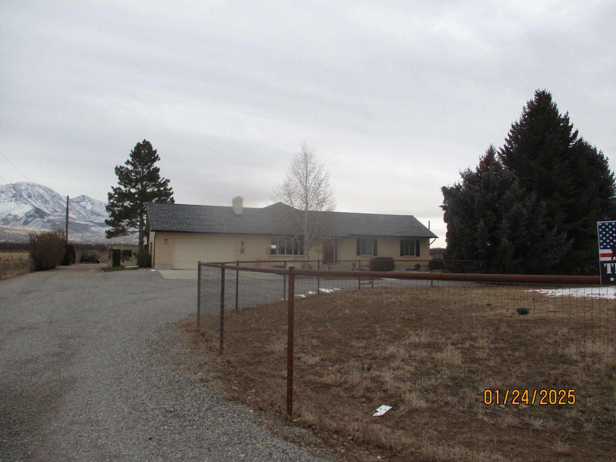 Total Photos: 1
|
| |
|
|
| Property Address: 5563 W 12000 SOUTH - PAYSON |
|
| Mailing Address: 5563 W 12000 S PAYSON, UT 84651-9619 |
|
| Acreage: 5.298752 |
|
| Last Document:
139868-2020
|
|
| Subdivision Map Filing |
|
| Taxing Description:
COM N 89 DEG 41' 10" E 678.83 FT ALONG SEC. LINE FR NW COR. SEC. 25, T9S, R1E, SLB&M.; N 89 DEG 41' 10" E 329.5 FT ALONG SEC. LINE; S 0 DEG 36' 53" E 700.53 FT ALONG A FENCE AND EXTENTION; S 89 DEG 33' 34" W 329.5 FT; N 0 DEG 36' 53" W 701.26 FT TO BEG. AREA 5.299 AC.
*Taxing description NOT FOR LEGAL DOCUMENTS
|
|
- Owner Names
- Value History
- Tax History
- Location
- Photos
- Documents
- Aerial Image
| |
----- Real Estate Values ----- |
---Improvements--- |
---Greenbelt--- |
Total |
| Year |
Com |
Res |
Agr |
Tot |
Com |
Res |
Agr |
Tot |
Land |
Homesite |
Tot |
Market Value |
| 2024 |
$0 |
$175,900 |
$192,000 |
$367,900 |
$0 |
$420,500 |
$6,900 |
$427,400 |
$1,621 |
$112,000 |
$113,621 |
$795,300 |
| 2023 |
$0 |
$175,900 |
$192,000 |
$367,900 |
$0 |
$407,600 |
$6,400 |
$414,000 |
$1,732 |
$112,000 |
$113,732 |
$781,900 |
| 2022 |
$0 |
$187,500 |
$204,700 |
$392,200 |
$0 |
$307,100 |
$33,700 |
$340,800 |
$2,202 |
$112,000 |
$114,202 |
$733,000 |
| 2021 |
$0 |
$150,000 |
$120,400 |
$270,400 |
$0 |
$230,900 |
$30,600 |
$261,500 |
$2,505 |
$80,000 |
$82,505 |
$531,900 |
| 2020 |
$0 |
$125,000 |
$107,500 |
$232,500 |
$0 |
$230,900 |
$30,600 |
$261,500 |
$2,737 |
$28,000 |
$30,737 |
$494,000 |
| 2019 |
$0 |
$110,000 |
$73,100 |
$183,100 |
$0 |
$209,900 |
$30,600 |
$240,500 |
$3,252 |
$28,000 |
$31,252 |
$423,600 |
| 2018 |
$0 |
$90,000 |
$73,100 |
$163,100 |
$0 |
$218,500 |
$0 |
$218,500 |
$3,439 |
$28,000 |
$31,439 |
$381,600 |
| 2017 |
$0 |
$75,000 |
$73,100 |
$148,100 |
$0 |
$211,700 |
$0 |
$211,700 |
$3,409 |
$28,000 |
$31,409 |
$359,800 |
| 2016 |
$0 |
$55,000 |
$73,100 |
$128,100 |
$0 |
$231,700 |
$0 |
$231,700 |
$3,338 |
$28,000 |
$31,338 |
$359,800 |
| Year |
General Taxes |
Adjustments |
Net Taxes |
Fees |
Payments |
Tax Balance* |
Balance Due |
Tax District |
| 2025 |
$0.00 |
$0.00 |
$0.00 |
$0.00 |
|
($750.00)
|
($750.00) |
120 - NEBO SCHOOL DIST S/A 6-7-8 |
| 2024 |
$3,015.17 |
$0.00 |
$3,015.17 |
$0.00 |
|
$0.00
|
$0.00 |
120 - NEBO SCHOOL DIST S/A 6-7-8 |
| 2023 |
$2,937.94 |
$0.00 |
$2,937.94 |
$0.00 |
|
$0.00
|
$0.00 |
120 - NEBO SCHOOL DIST S/A 6-7-8 |
| 2022 |
$2,711.76 |
$0.00 |
$2,711.76 |
$0.00 |
|
$0.00
|
$0.00 |
120 - NEBO SCHOOL DIST S/A 6-7-8 |
| 2021 |
$2,418.99 |
$0.00 |
$2,418.99 |
$0.00 |
|
$0.00
|
$0.00 |
120 - NEBO SCHOOL DIST S/A 6-7-8 |
| 2020 |
$2,145.16 |
$0.00 |
$2,145.16 |
$0.00 |
|
$0.00
|
$0.00 |
120 - NEBO SCHOOL DIST S/A 6-7-8 |
| 2019 |
$1,970.27 |
$0.00 |
$1,970.27 |
$0.00 |
|
$0.00
|
$0.00 |
120 - NEBO SCHOOL DIST S/A 6-7-8 |
| 2018 |
$1,738.23 |
$0.00 |
$1,738.23 |
$0.00 |
|
$0.00
|
$0.00 |
120 - NEBO SCHOOL DIST S/A 6-7-8 |
| 2017 |
$1,739.51 |
$0.00 |
$1,739.51 |
$0.00 |
|
$0.00
|
$0.00 |
120 - NEBO SCHOOL DIST S/A 6-7-8 |
| 2016 |
$1,939.13 |
$0.00 |
$1,939.13 |
$0.00 |
|
$0.00
|
$0.00 |
120 - NEBO SCHOOL DIST S/A 6-7-8 |
* Note: Original tax amount (Does not include applicable interest and/or fees).
| Entry # |
Date |
Recorded |
Type |
Party1 (Grantor) |
Party2 (Grantee) |
| 186381-2021 |
11/01/2021 |
11/02/2021 |
FARM |
HARMER, BRENT & RHODA LYNN TEE (ET AL) |
WHOM OF INTEREST |
| 139868-2020 |
09/09/2020 |
09/15/2020 |
QCD |
HARMER, BRENT C & RHODA LYNN M |
HARMER, BRENT & RHODA LYNN TEE (ET AL) |
| 31765-2018 |
03/13/2018 |
04/04/2018 |
N |
UTAH COUNTY |
WHOM OF INTEREST |
| 15150-2016 |
02/17/2016 |
02/24/2016 |
FARM |
HARMER, BRENT C & RHODA LYNN M |
WHOM OF INTEREST |
| 100257-2015 |
11/04/2015 |
11/04/2015 |
RSUBTEE |
MORTGAGE ELECTRONIC REGISTRATION SYSTEMS INC (ET AL) |
HARMER, BRENT C & RHODA LYNN M |
| 94753-2015 |
07/28/2015 |
10/19/2015 |
REC |
ZIONS FIRST NATIONAL BANK TEE |
LUNDELL, CAREY M TEE |
| 12418-2015 |
02/17/2015 |
02/18/2015 |
QCD |
HARMER, BRENT C & RHODA LYNN M |
HARMER, BRENT C & RHODA LYNN M |
Main Menu Comments or Concerns on Value/Appraisal - Assessor's Office
Documents/Owner/Parcel information - Recorder's Office
Address Change for Tax Notice
This page was created on 3/23/2025 11:05:34 PM |