Property Information
mobile view
| Serial Number: 34:586:0001 |
Serial Life: 2017... |
|
|

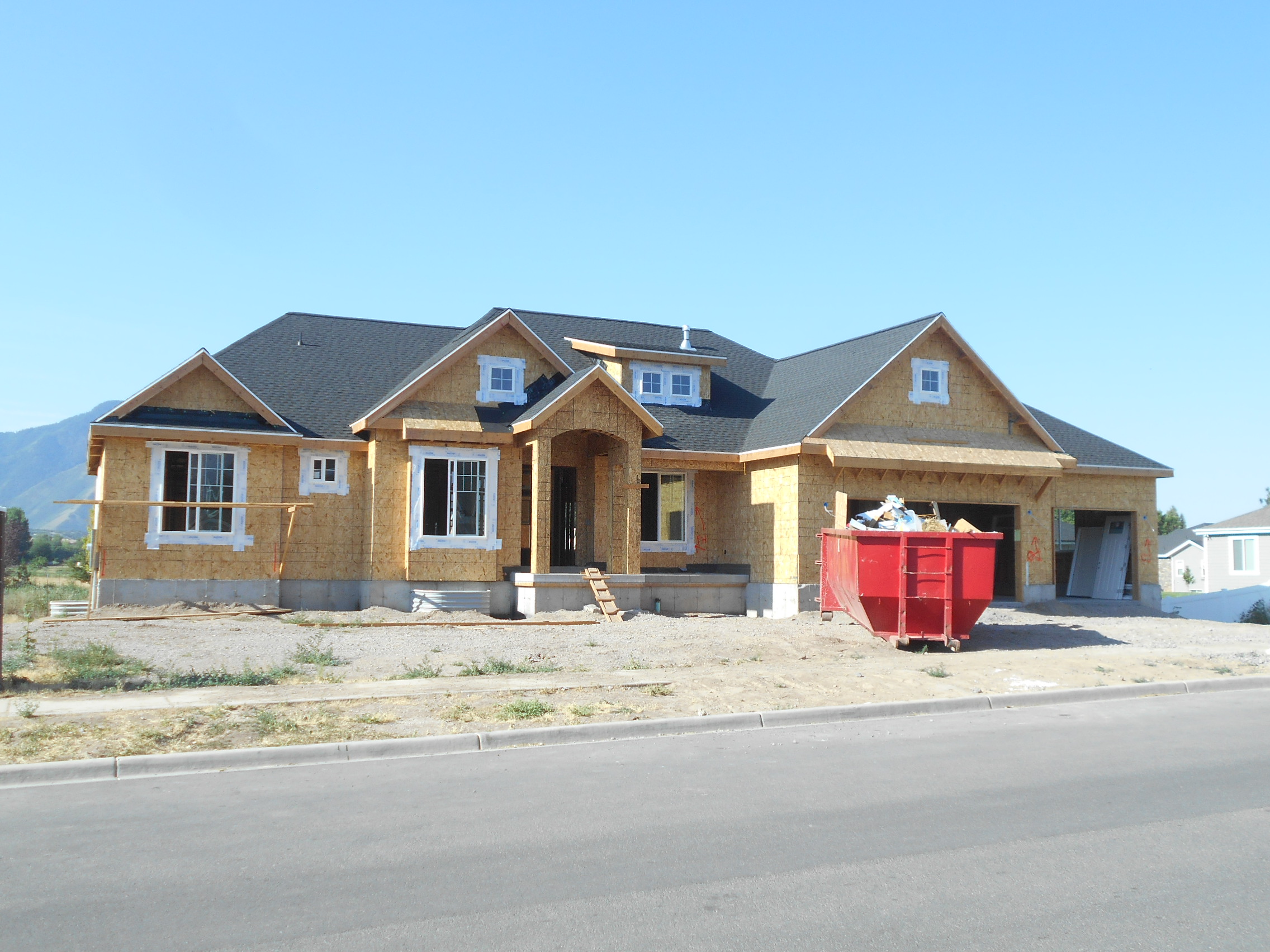
Total Photos: 2
|
| |
|
|
| Property Address: 245 W 600 SOUTH - MAPLETON |
|
| Mailing Address: 245 W 600 S MAPLETON, UT 84664-5688 |
|
| Acreage: 0.499748 |
|
| Last Document:
61506-2016
|
|
| Subdivision Map Filing |
|
| Taxing Description:
LOT 1, PLAT A, AUTUMN LANE SUB AREA 0.500 AC.
*Taxing description NOT FOR LEGAL DOCUMENTS
|
|
- Owner Names
- Value History
- Tax History
- Location
- Photos
- Documents
- Aerial Image
| |
----- Real Estate Values ----- |
---Improvements--- |
---Greenbelt--- |
Total |
| Year |
Com |
Res |
Agr |
Tot |
Com |
Res |
Agr |
Tot |
Land |
Homesite |
Tot |
Market Value |
| 2024 |
$0 |
$320,200 |
$0 |
$320,200 |
$0 |
$634,700 |
$0 |
$634,700 |
$0 |
$0 |
$0 |
$954,900 |
| 2023 |
$0 |
$320,100 |
$0 |
$320,100 |
$0 |
$704,000 |
$0 |
$704,000 |
$0 |
$0 |
$0 |
$1,024,100 |
| 2022 |
$0 |
$341,300 |
$0 |
$341,300 |
$0 |
$630,000 |
$0 |
$630,000 |
$0 |
$0 |
$0 |
$971,300 |
| 2021 |
$0 |
$220,200 |
$0 |
$220,200 |
$0 |
$484,600 |
$0 |
$484,600 |
$0 |
$0 |
$0 |
$704,800 |
| 2020 |
$0 |
$194,900 |
$0 |
$194,900 |
$0 |
$466,000 |
$0 |
$466,000 |
$0 |
$0 |
$0 |
$660,900 |
| 2019 |
$0 |
$194,900 |
$0 |
$194,900 |
$0 |
$445,200 |
$0 |
$445,200 |
$0 |
$0 |
$0 |
$640,100 |
| 2018 |
$0 |
$166,500 |
$0 |
$166,500 |
$0 |
$0 |
$0 |
$0 |
$0 |
$0 |
$0 |
$166,500 |
| 2017 |
$0 |
$154,300 |
$0 |
$154,300 |
$0 |
$0 |
$0 |
$0 |
$0 |
$0 |
$0 |
$154,300 |
| Year |
General Taxes |
Adjustments |
Net Taxes |
Fees |
Payments |
Tax Balance* |
Balance Due |
Tax District |
| 2025 |
$0.00 |
$0.00 |
$0.00 |
$0.00 |
|
$0.00
|
$0.00 |
140 - MAPLETON CITY |
| 2024 |
$0.00 |
$0.00 |
$0.00 |
$0.00 |
|
$0.00
|
$0.00 |
140 - MAPLETON CITY |
| 2023 |
$5,713.66 |
$0.00 |
$5,713.66 |
$0.00 |
|
$0.00
|
$0.00 |
140 - MAPLETON CITY |
| 2022 |
$5,480.51 |
$0.00 |
$5,480.51 |
$0.00 |
|
$0.00
|
$0.00 |
140 - MAPLETON CITY |
| 2021 |
$4,709.44 |
$0.00 |
$4,709.44 |
$0.00 |
|
$0.00
|
$0.00 |
140 - MAPLETON CITY |
| 2020 |
$4,565.50 |
$0.00 |
$4,565.50 |
$0.00 |
|
$0.00
|
$0.00 |
140 - MAPLETON CITY |
| 2019 |
$4,332.04 |
$0.00 |
$4,332.04 |
$0.00 |
|
$0.00
|
$0.00 |
140 - MAPLETON CITY |
| 2018 |
$2,152.18 |
$0.00 |
$2,152.18 |
$0.00 |
|
$0.00
|
$0.00 |
140 - MAPLETON CITY |
| 2017 |
$2,067.00 |
$0.00 |
$2,067.00 |
$0.00 |
|
$0.00
|
$0.00 |
140 - MAPLETON CITY |
* Note: Original tax amount (Does not include applicable interest and/or fees).
| Entry # |
Date |
Recorded |
Type |
Party1 (Grantor) |
Party2 (Grantee) |
| 55746-2020 |
04/24/2020 |
04/28/2020 |
REC |
FIRST AMERICAN TITLE INSURANCE COMPANY TEE |
CHRISTENSEN, SHARON |
| 55745-2020 |
04/23/2020 |
04/28/2020 |
SUB TEE |
MORTGAGE ELECTRONIC REGISTRATION SYSTEMS INC |
FIRST AMERICAN TITLE INSURANCE COMPANY SUBTEE |
| 46459-2020 |
04/06/2020 |
04/10/2020 |
D TR |
CHRISTENSEN, SHARON |
CANOPY MORTGAGE LLC |
| 31870-2019 |
04/05/2019 |
04/17/2019 |
REC |
CENTRAL BANK TEE |
CHRISTENSEN, SHARON |
| 26988-2019 |
04/02/2019 |
04/02/2019 |
R LN |
OLD WORLD STONE IMPORTS |
CHRISTENSEN, SHARON |
| 20005-2019 |
03/08/2019 |
03/12/2019 |
D TR |
CHRISTENSEN, SHARON |
CANOPY MORTGAGE LLC |
| 17858-2019 |
03/04/2019 |
03/05/2019 |
N LN |
CHRISTENSEN, SHARON |
OLD WORLD STONE IMPORTS LLC BY (ET AL) |
| 32266-2018 |
04/06/2018 |
04/06/2018 |
D TR |
CHRISTENSEN, SHARON |
CENTRAL BANK |
| 120612-2017 |
10/19/2017 |
12/06/2017 |
GEO HAZ |
CHRISTENSEN, SHARON |
WHOM OF INTEREST |
| 76367-2017 |
07/31/2017 |
08/07/2017 |
REC |
UTAH COMMUNITY FEDERAL CREDIT UNION TEE |
AUTUMN LANE SUBDIVISION LLC |
| 88157-2016 |
08/31/2016 |
09/09/2016 |
P REC |
UTAH COMMUNITY FEDERAL CREDIT UNION TEE |
AUTUMN LANE SUBDIVISION LLC |
| 83799-2016 |
08/26/2016 |
08/30/2016 |
WD |
AUTUMN LANE SUBDIVISION LLC |
CHRISTENSEN, SHARON |
| 64684-2016 |
07/14/2016 |
07/14/2016 |
RES COV |
AUTUMN LANE SUBDIVISION LLC |
WHOM OF INTEREST |
| 61506-2016 |
10/07/2015 |
07/05/2016 |
S PLAT |
AUTUMN LANE SUBDIVISION LLC |
AUTUMN LANE PLAT A |
Main Menu Comments or Concerns on Value/Appraisal - Assessor's Office
Documents/Owner/Parcel information - Recorder's Office
Address Change for Tax Notice
This page was created on 8/13/2024 6:06:06 AM |