Property Information
mobile view
| Serial Number: 35:310:0002 |
Serial Life: 1999... |
|
|
 Total Photos: 9
|
| |
|
|
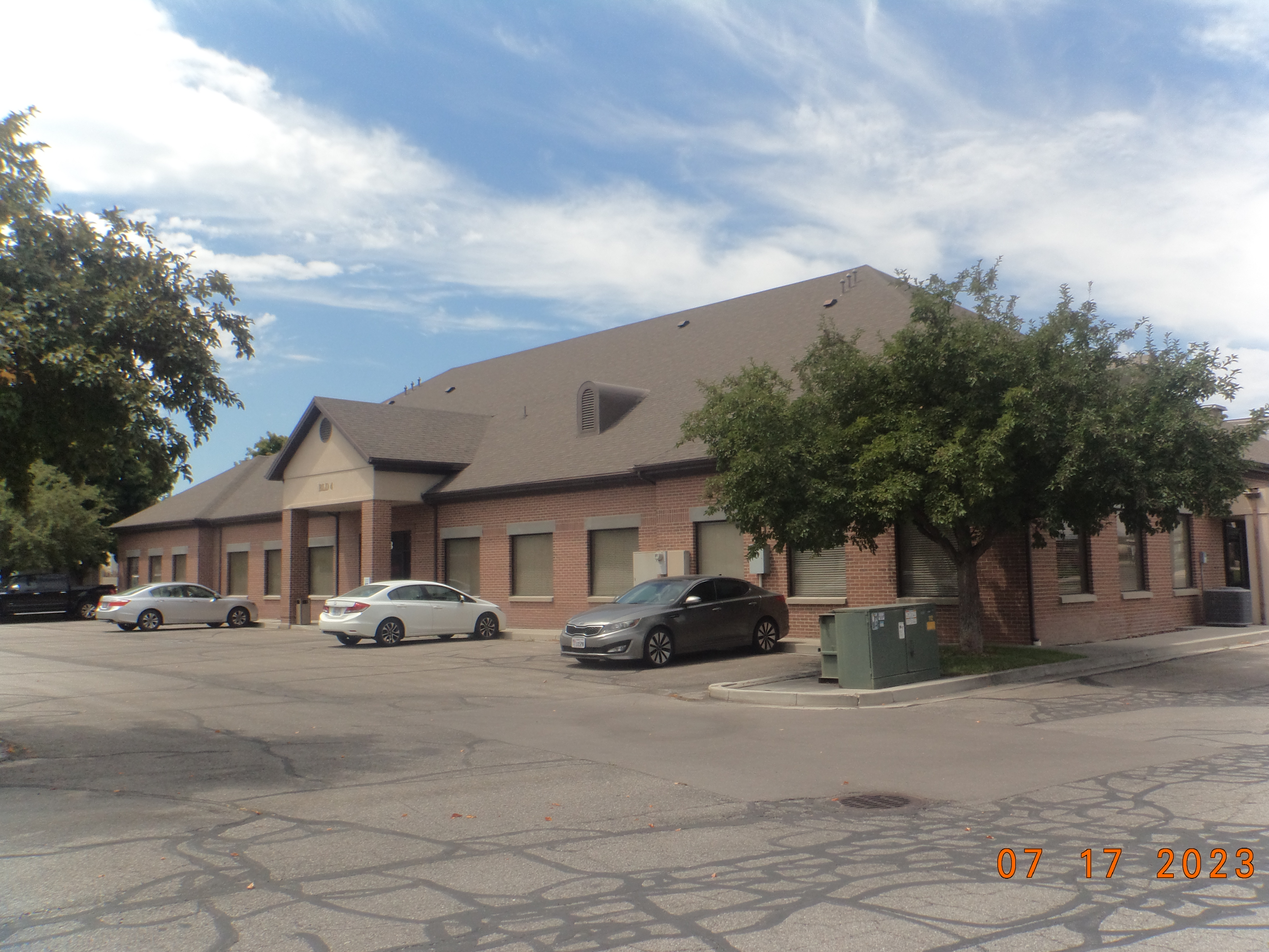
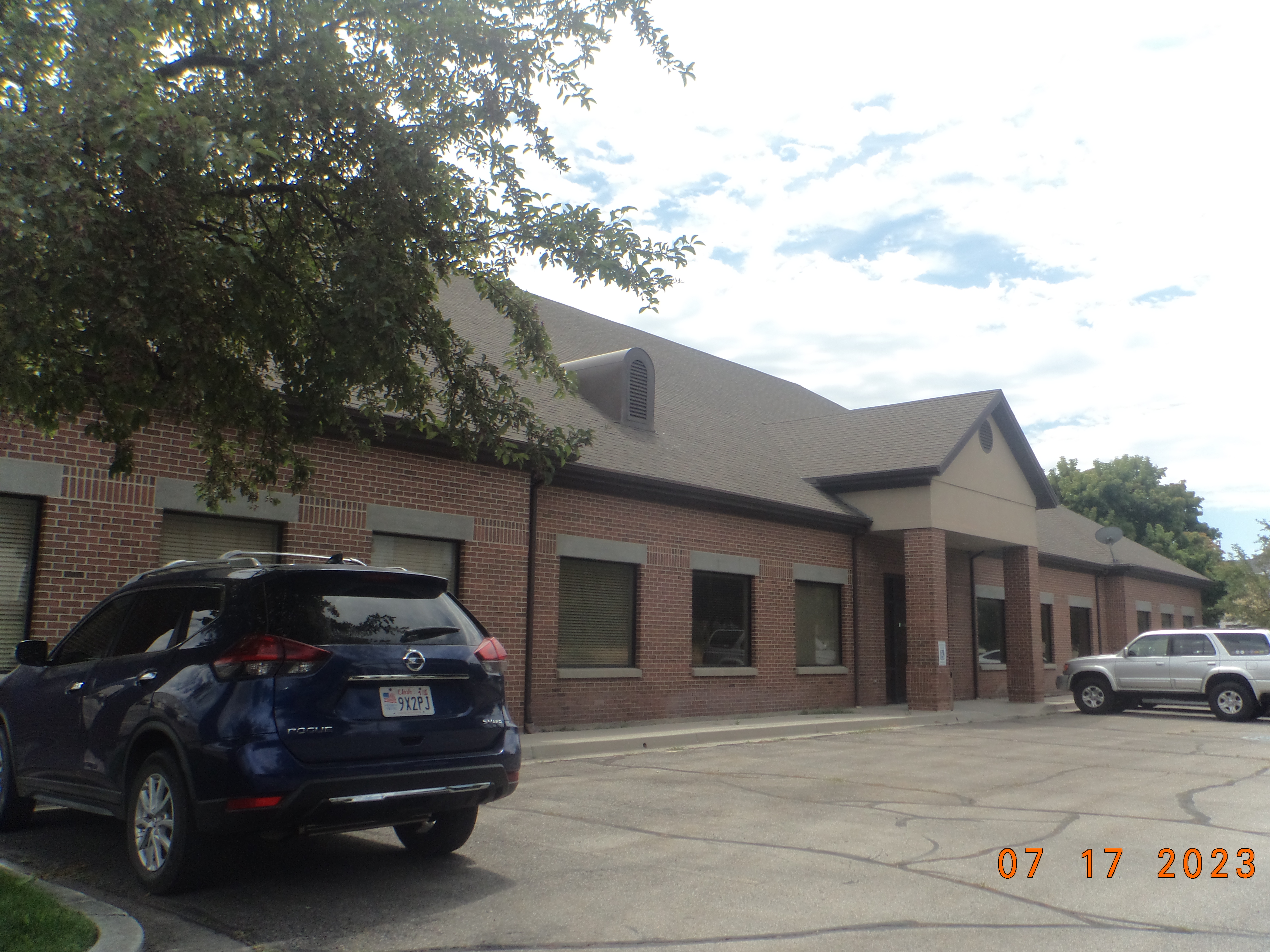
| Property Address: 313 S 740 EAST - AMERICAN FORK |
|
| Mailing Address: 1112 S 500 E OREM, UT 84097-7129 |
|
| Acreage: 1.123 |
|
| Last Document:
116739-1998
|
|
| Subdivision Map Filing |
|
| Taxing Description:
LOT 2, BROADSTONE SQUARE #3 PUD SUBDV. AREA 1.123 AC.
*Taxing description NOT FOR LEGAL DOCUMENTS
|
|
- Owner Names
- Value History
- Tax History
- Location
- Photos
- Documents
- Aerial Image
| |
----- Real Estate Values ----- |
---Improvements--- |
---Greenbelt--- |
Total |
| Year |
Com |
Res |
Agr |
Tot |
Com |
Res |
Agr |
Tot |
Land |
Homesite |
Tot |
Market Value |
| 2024 |
$588,400 |
$0 |
$0 |
$588,400 |
$1,071,600 |
$0 |
$0 |
$1,071,600 |
$0 |
$0 |
$0 |
$1,660,000 |
| 2023 |
$576,900 |
$0 |
$0 |
$576,900 |
$1,093,700 |
$0 |
$0 |
$1,093,700 |
$0 |
$0 |
$0 |
$1,670,600 |
| 2022 |
$557,700 |
$0 |
$0 |
$557,700 |
$1,013,400 |
$0 |
$0 |
$1,013,400 |
$0 |
$0 |
$0 |
$1,571,100 |
| 2021 |
$575,800 |
$0 |
$0 |
$575,800 |
$746,100 |
$0 |
$0 |
$746,100 |
$0 |
$0 |
$0 |
$1,321,900 |
| 2020 |
$575,800 |
$0 |
$0 |
$575,800 |
$786,900 |
$0 |
$0 |
$786,900 |
$0 |
$0 |
$0 |
$1,362,700 |
| 2019 |
$476,000 |
$0 |
$0 |
$476,000 |
$786,900 |
$0 |
$0 |
$786,900 |
$0 |
$0 |
$0 |
$1,262,900 |
| 2018 |
$453,500 |
$0 |
$0 |
$453,500 |
$715,400 |
$0 |
$0 |
$715,400 |
$0 |
$0 |
$0 |
$1,168,900 |
| 2017 |
$431,900 |
$0 |
$0 |
$431,900 |
$734,100 |
$0 |
$0 |
$734,100 |
$0 |
$0 |
$0 |
$1,166,000 |
| 2016 |
$411,400 |
$0 |
$0 |
$411,400 |
$729,600 |
$0 |
$0 |
$729,600 |
$0 |
$0 |
$0 |
$1,141,000 |
| 2015 |
$391,800 |
$0 |
$0 |
$391,800 |
$729,600 |
$0 |
$0 |
$729,600 |
$0 |
$0 |
$0 |
$1,121,400 |
| 2014 |
$373,300 |
$0 |
$0 |
$373,300 |
$729,600 |
$0 |
$0 |
$729,600 |
$0 |
$0 |
$0 |
$1,102,900 |
| 2013 |
$339,400 |
$0 |
$0 |
$339,400 |
$565,666 |
$0 |
$0 |
$565,666 |
$0 |
$0 |
$0 |
$905,066 |
| 2012 |
$339,400 |
$0 |
$0 |
$339,400 |
$663,300 |
$0 |
$0 |
$663,300 |
$0 |
$0 |
$0 |
$1,002,700 |
| 2011 |
$339,400 |
$0 |
$0 |
$339,400 |
$663,300 |
$0 |
$0 |
$663,300 |
$0 |
$0 |
$0 |
$1,002,700 |
| 2010 |
$368,872 |
$0 |
$0 |
$368,872 |
$676,788 |
$0 |
$0 |
$676,788 |
$0 |
$0 |
$0 |
$1,045,660 |
| 2009 |
$376,400 |
$0 |
$0 |
$376,400 |
$907,000 |
$0 |
$0 |
$907,000 |
$0 |
$0 |
$0 |
$1,283,400 |
| 2008 |
$279,200 |
$0 |
$0 |
$279,200 |
$913,100 |
$0 |
$0 |
$913,100 |
$0 |
$0 |
$0 |
$1,192,300 |
| 2007 |
$265,900 |
$0 |
$0 |
$265,900 |
$869,600 |
$0 |
$0 |
$869,600 |
$0 |
$0 |
$0 |
$1,135,500 |
| 2006 |
$221,559 |
$0 |
$0 |
$221,559 |
$790,560 |
$0 |
$0 |
$790,560 |
$0 |
$0 |
$0 |
$1,012,119 |
| 2005 |
$221,559 |
$0 |
$0 |
$221,559 |
$790,560 |
$0 |
$0 |
$790,560 |
$0 |
$0 |
$0 |
$1,012,119 |
| 2004 |
$221,559 |
$0 |
$0 |
$221,559 |
$790,560 |
$0 |
$0 |
$790,560 |
$0 |
$0 |
$0 |
$1,012,119 |
| 2003 |
$221,559 |
$0 |
$0 |
$221,559 |
$790,560 |
$0 |
$0 |
$790,560 |
$0 |
$0 |
$0 |
$1,012,119 |
| 2002 |
$221,559 |
$0 |
$0 |
$221,559 |
$790,560 |
$0 |
$0 |
$790,560 |
$0 |
$0 |
$0 |
$1,012,119 |
| 2001 |
$190,016 |
$0 |
$0 |
$190,016 |
$678,010 |
$0 |
$0 |
$678,010 |
$0 |
$0 |
$0 |
$868,026 |
| 2000 |
$177,585 |
$0 |
$0 |
$177,585 |
$678,010 |
$0 |
$0 |
$678,010 |
$0 |
$0 |
$0 |
$855,595 |
| 1999 |
$177,585 |
$0 |
$0 |
$177,585 |
$674,578 |
$0 |
$0 |
$674,578 |
$0 |
$0 |
$0 |
$852,163 |
| Year |
General Taxes |
Adjustments |
Net Taxes |
Fees |
Payments |
Tax Balance* |
Balance Due |
Tax District |
| 2025 |
$0.00 |
$0.00 |
$0.00 |
$0.00 |
|
$0.00
|
$0.00 |
060 - AMERICAN FORK CITY |
| 2024 |
$14,940.00 |
$0.00 |
$14,940.00 |
$0.00 |
|
$0.00
|
$0.00 |
060 - AMERICAN FORK CITY |
| 2023 |
$14,181.72 |
$0.00 |
$14,181.72 |
$0.00 |
|
$0.00
|
$0.00 |
060 - AMERICAN FORK CITY |
| 2022 |
$13,514.60 |
$0.00 |
$13,514.60 |
$0.00 |
|
$0.00
|
$0.00 |
060 - AMERICAN FORK CITY |
| 2021 |
$13,236.18 |
$0.00 |
$13,236.18 |
$0.00 |
|
$0.00
|
$0.00 |
060 - AMERICAN FORK CITY |
| 2020 |
$14,068.51 |
$0.00 |
$14,068.51 |
$0.00 |
|
$0.00
|
$0.00 |
060 - AMERICAN FORK CITY |
| 2019 |
$12,606.27 |
$0.00 |
$12,606.27 |
$0.00 |
|
$0.00
|
$0.00 |
060 - AMERICAN FORK CITY |
| 2018 |
$12,203.32 |
$0.00 |
$12,203.32 |
$0.00 |
|
$0.00
|
$0.00 |
060 - AMERICAN FORK CITY |
| 2017 |
$12,405.07 |
$0.00 |
$12,405.07 |
$0.00 |
|
$0.00
|
$0.00 |
060 - AMERICAN FORK CITY |
| 2016 |
$13,065.59 |
$0.00 |
$13,065.59 |
$0.00 |
|
$0.00
|
$0.00 |
060 - AMERICAN FORK CITY |
| 2015 |
$13,530.81 |
$0.00 |
$13,530.81 |
$0.00 |
|
$0.00
|
$0.00 |
060 - AMERICAN FORK CITY |
| 2014 |
$13,490.67 |
$0.00 |
$13,490.67 |
$0.00 |
|
$0.00
|
$0.00 |
060 - AMERICAN FORK CITY |
| 2013 |
$14,091.56 |
($2,160.98) |
$11,930.58 |
$0.00 |
|
$0.00
|
$0.00 |
060 - AMERICAN FORK CITY |
| 2012 |
$13,484.31 |
$0.00 |
$13,484.31 |
$0.00 |
|
$0.00
|
$0.00 |
060 - AMERICAN FORK CITY |
| 2011 |
$13,448.21 |
$0.00 |
$13,448.21 |
$0.00 |
|
$0.00
|
$0.00 |
060 - AMERICAN FORK CITY |
| 2010 |
$15,265.10 |
($2,099.19) |
$13,165.91 |
$0.00 |
|
$0.00
|
$0.00 |
060 - AMERICAN FORK CITY |
| 2009 |
$14,875.89 |
$0.00 |
$14,875.89 |
$0.00 |
|
$0.00
|
$0.00 |
060 - AMERICAN FORK CITY |
| 2008 |
$12,991.30 |
$0.00 |
$12,991.30 |
$0.00 |
|
$0.00
|
$0.00 |
060 - AMERICAN FORK CITY |
| 2007 |
$11,893.23 |
$0.00 |
$11,893.23 |
$0.00 |
|
$0.00
|
$0.00 |
060 - AMERICAN FORK CITY |
| 2006 |
$11,397.47 |
$0.00 |
$11,397.47 |
$0.00 |
|
$0.00
|
$0.00 |
060 - AMERICAN FORK CITY |
| 2005 |
$12,329.63 |
$0.00 |
$12,329.63 |
$0.00 |
|
$0.00
|
$0.00 |
060 - AMERICAN FORK CITY |
| 2004 |
$12,378.22 |
$0.00 |
$12,378.22 |
$0.00 |
|
$0.00
|
$0.00 |
060 - AMERICAN FORK CITY |
| 2003 |
$12,179.84 |
$0.00 |
$12,179.84 |
$0.00 |
|
$0.00
|
$0.00 |
060 - AMERICAN FORK CITY |
| 2002 |
$11,240.59 |
$0.00 |
$11,240.59 |
$0.00 |
|
$0.00
|
$0.00 |
060 - AMERICAN FORK CITY |
| 2001 |
$9,282.67 |
$0.00 |
$9,282.67 |
$0.00 |
|
$0.00
|
$0.00 |
060 - AMERICAN FORK CITY |
| 2000 |
$9,509.94 |
$0.00 |
$9,509.94 |
$0.00 |
|
$0.00
|
$0.00 |
060 - AMERICAN FORK CITY |
| 1999 |
$9,582.57 |
$0.00 |
$9,582.57 |
$0.00 |
|
$0.00
|
$0.00 |
060 - AMERICAN FORK CITY |
* Note: Original tax amount (Does not include applicable interest and/or fees).
| Entry # |
Date |
Recorded |
Type |
Party1 (Grantor) |
Party2 (Grantee) |
| 58844-2023 |
09/08/9129 |
09/07/2023 |
AF DC |
CORDNER, COLLEEN F TEE (ET AL) |
CORDNER, COLLEEN F TEE (ET AL) |
| 28678-2010 |
03/31/2010 |
04/08/2010 |
WD |
L H PERRY INVESTMENTS LLC (ET AL) |
L H PERRY INVESTMENTS LLC |
| 114949-2008 |
10/20/2008 |
10/22/2008 |
CT |
STATE OF UTAH |
WHOM OF INTEREST |
| 107508-2008 |
09/30/2008 |
09/30/2008 |
RESOL |
BOARD OF COUNTY COMMISSIONERS UTAH COUNTY |
WHOM OF INTEREST |
| 4116-2001 |
|
01/17/2001 |
T FN ST |
PALMER COKING COAL CO |
MORRIS, TIMOTHY H |
| 1794-2001 |
01/08/2001 |
01/08/2001 |
SP WD |
CORDNER FAMILY LIMITED PARTNERSHIP (ET AL) |
CORDNER, RAYMOND G & COLLEEN F TEE |
| 98043-2000 |
11/28/2000 |
12/11/2000 |
REC |
TITLE WEST TITLE CO TEE |
MORRIS, TIMOTHY |
| 98042-2000 |
08/30/2000 |
12/11/2000 |
SUB TEE |
PALMER COKING COAL COMPANY |
TITLE WEST TITLE CO SUBTEE |
| 68703-2000 |
08/25/2000 |
08/31/2000 |
WD |
MORRIS, TIMOTHY H |
CORDNER FAMILY LIMITED PARTNERHSIP |
| 14857-2000 |
|
02/24/2000 |
FN ST |
MORRIS, TIMOTHY H |
PALMER COKING COAL COMPANY |
| 14856-2000 |
02/21/2000 |
02/24/2000 |
D TR |
MORRIS, TIMOTHY H |
PALMER COKING COAL COMPANY |
| 1195-1999 |
12/04/1998 |
01/06/1999 |
REC |
BANK OF AMERICAN FORK TEE |
BROADSTONE INVESTMENT LC |
| 131003-1998 |
12/16/1998 |
12/16/1998 |
SCRIVAF |
FIRST AMERICAN TITLE INSURANCE COMPANY (ET AL) |
WHOM OF INTEREST |
| 116740-1998 |
11/09/1998 |
11/12/1998 |
TR D |
MORRIS, TIMOTHY H |
MOUNTAIN AMERICA CREDIT UNION |
| 116739-1998 |
11/10/1998 |
11/12/1998 |
WD |
BROADSTONE INVESTMENT LC |
MORRIS, TIMOTHY H |
| 58737-1998 |
06/11/1998 |
06/11/1998 |
NOT COM |
ELLSWORTH PECK CONSTRUCTION |
BROADSTONE III |
| 58736-1998 |
06/11/1998 |
06/11/1998 |
NOT COM |
ELLSWORTH PECK CONSTRUCTION |
BROADSTONE IV |
| 33575-1998 |
04/06/1998 |
04/07/1998 |
QCD |
LH PERRY INVESTMENTS LTD |
BROADSTONE INVESTMENTS LC |
| 33231-1998 |
04/02/1998 |
04/06/1998 |
D TR |
BROADSTONE INVESTMENT LC |
BANK OF AMERICAN FORK |
| 19917-1998 |
02/24/1998 |
03/03/1998 |
DECLCOV |
BROADSTONE DEVELOPMENT LC BY (ET AL) |
WHOM OF INTEREST |
| 19916-1998 |
10/14/1997 |
03/03/1998 |
P PLAT |
BROADSTONE INVESTMENTS LC |
BROADSTONE SQUARE #03 PUD |
Main Menu Comments or Concerns on Value/Appraisal - Assessor's Office
Documents/Owner/Parcel information - Recorder's Office
Address Change for Tax Notice
This page was created on 3/9/2025 12:35:15 PM |