Property Information
mobile view
| Serial Number: 37:007:0015 |
Serial Life: 2015... |
|
|
 Total Photos: 3
|
| |
|
|
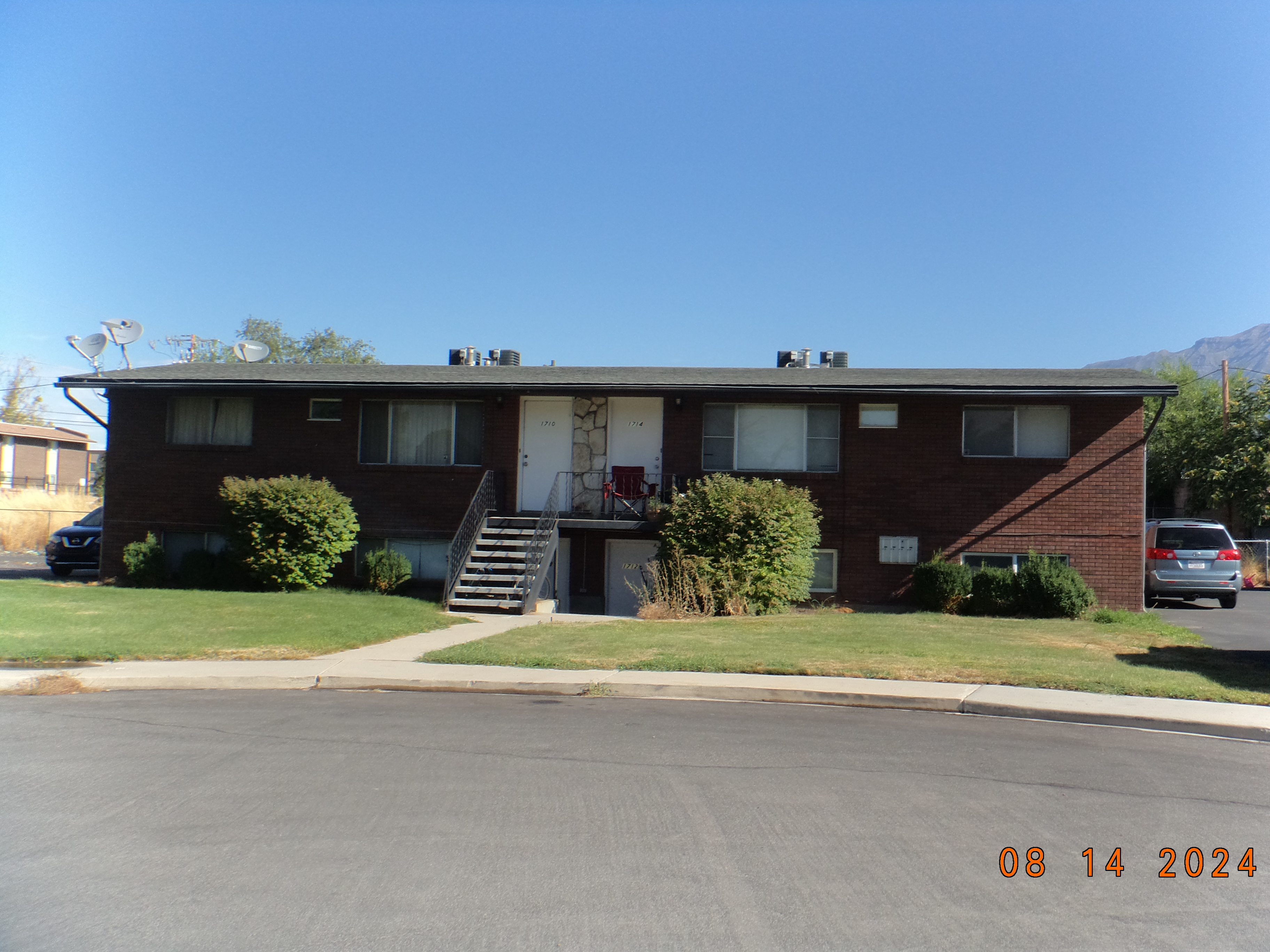
| Property Address: 1708 S 500 EAST - OREM
more see "Addrs" tab below..
|
|
| Mailing Address: %REMS INC PO BOX 1741 PROVO, UT 84603-1741 |
|
| Acreage: 0.309831 |
|
| Last Document:
29564-2014
|
|
| Subdivision Map Filing |
|
| Taxing Description:
PART LOT 5, PLAT A, DAWN MEADOWS SUBDV DESCRIBED AS FOLLOWS:; COM N 1940.7 FT & E 727.17 FT FR S 1/4 COR. SEC. 26, T6S, R2E, SLB&M.; N 89 DEG 50' 41" W 173.76 FT; S 0 DEG 8' 12" E 9.25 FT; S 44 DEG 33' 31" E 138.73 FT; ALONG A CURVE TO R (CHORD BEARS: S 67 DEG 4' 55" E 83.14 FT, RADIUS = 45 FT); N 0 DEG 4' 12" W 140 FT TO BEG. AREA 0.310 AC.
*Taxing description NOT FOR LEGAL DOCUMENTS
|
|
- Owner Names
- Value History
- Tax History
- Location
- Photos
- Documents
- Aerial Image
- Addrs
| |
----- Real Estate Values ----- |
---Improvements--- |
---Greenbelt--- |
Total |
| Year |
Com |
Res |
Agr |
Tot |
Com |
Res |
Agr |
Tot |
Land |
Homesite |
Tot |
Market Value |
| 2024 |
$0 |
$238,500 |
$0 |
$238,500 |
$0 |
$556,400 |
$0 |
$556,400 |
$0 |
$0 |
$0 |
$794,900 |
| 2023 |
$0 |
$236,100 |
$0 |
$236,100 |
$0 |
$550,900 |
$0 |
$550,900 |
$0 |
$0 |
$0 |
$787,000 |
| 2022 |
$0 |
$183,300 |
$0 |
$183,300 |
$0 |
$542,100 |
$0 |
$542,100 |
$0 |
$0 |
$0 |
$725,400 |
| 2021 |
$0 |
$141,000 |
$0 |
$141,000 |
$0 |
$417,000 |
$0 |
$417,000 |
$0 |
$0 |
$0 |
$558,000 |
| 2020 |
$0 |
$131,300 |
$0 |
$131,300 |
$0 |
$394,000 |
$0 |
$394,000 |
$0 |
$0 |
$0 |
$525,300 |
| 2019 |
$0 |
$141,600 |
$0 |
$141,600 |
$0 |
$348,700 |
$0 |
$348,700 |
$0 |
$0 |
$0 |
$490,300 |
| 2018 |
$0 |
$246,600 |
$0 |
$246,600 |
$0 |
$179,800 |
$0 |
$179,800 |
$0 |
$0 |
$0 |
$426,400 |
| 2017 |
$0 |
$93,500 |
$0 |
$93,500 |
$0 |
$280,500 |
$0 |
$280,500 |
$0 |
$0 |
$0 |
$374,000 |
| 2016 |
$0 |
$97,600 |
$0 |
$97,600 |
$0 |
$292,600 |
$0 |
$292,600 |
$0 |
$0 |
$0 |
$390,200 |
| 2015 |
$0 |
$90,100 |
$0 |
$90,100 |
$0 |
$270,400 |
$0 |
$270,400 |
$0 |
$0 |
$0 |
$360,500 |
| Year |
General Taxes |
Adjustments |
Net Taxes |
Fees |
Payments |
Tax Balance* |
Balance Due |
Tax District |
| 2025 |
$0.00 |
$0.00 |
$0.00 |
$0.00 |
|
$0.00
|
$0.00 |
090 - OREM CITY |
| 2024 |
$3,575.38 |
$0.00 |
$3,575.38 |
$0.00 |
|
$0.00
|
$0.00 |
090 - OREM CITY |
| 2023 |
$3,293.56 |
$0.00 |
$3,293.56 |
$0.00 |
|
$0.00
|
$0.00 |
090 - OREM CITY |
| 2022 |
$3,133.51 |
$0.00 |
$3,133.51 |
$0.00 |
|
$0.00
|
$0.00 |
090 - OREM CITY |
| 2021 |
$2,893.45 |
$0.00 |
$2,893.45 |
$0.00 |
|
$0.00
|
$0.00 |
090 - OREM CITY |
| 2020 |
$2,771.56 |
$0.00 |
$2,771.56 |
$0.00 |
|
$0.00
|
$0.00 |
090 - OREM CITY |
| 2019 |
$2,487.66 |
$0.00 |
$2,487.66 |
$0.00 |
|
$0.00
|
$0.00 |
090 - OREM CITY |
| 2018 |
$2,264.29 |
$0.00 |
$2,264.29 |
$0.00 |
|
$0.00
|
$0.00 |
090 - OREM CITY |
| 2017 |
$2,039.10 |
$0.00 |
$2,039.10 |
$0.00 |
|
$0.00
|
$0.00 |
090 - OREM CITY |
| 2016 |
$2,307.06 |
$0.00 |
$2,307.06 |
$0.00 |
|
$0.00
|
$0.00 |
090 - OREM CITY |
| 2015 |
$2,253.79 |
$0.00 |
$2,253.79 |
$0.00 |
|
$0.00
|
$0.00 |
090 - OREM CITY |
* Note: Original tax amount (Does not include applicable interest and/or fees).
| Entry # |
Date |
Recorded |
Type |
Party1 (Grantor) |
Party2 (Grantee) |
| 167987-2021 |
09/29/2021 |
09/29/2021 |
REC |
TERRY, RICHARD C TEE |
RLS PROPERTIES-1708 SOUTH LLC |
| 167986-2021 |
09/26/2021 |
09/29/2021 |
SUB TEE |
STONE, MABLE JANE TEE (ET AL) |
TERRY, RICHARD C SUCTEE |
| 29564-2014 |
03/27/2014 |
05/02/2014 |
BLA |
STAY SUMMIT RIDGE I LLC BY (ET AL) |
RLS PROPERTIES-1708 SOUTH LLC |
1708 S 500 EAST - OREM
1710 S 500 EAST - OREM
1712 S 500 EAST - OREM
1714 S 500 EAST - OREM
Main Menu Comments or Concerns on Value/Appraisal - Assessor's Office
Documents/Owner/Parcel information - Recorder's Office
Address Change for Tax Notice
This page was created on 1/10/2025 6:53:14 AM |

