Property Information
mobile view
| Serial Number: 54:160:0016 |
Serial Life: 2002... |
|
|
 Total Photos: 3
|
| |
|
|
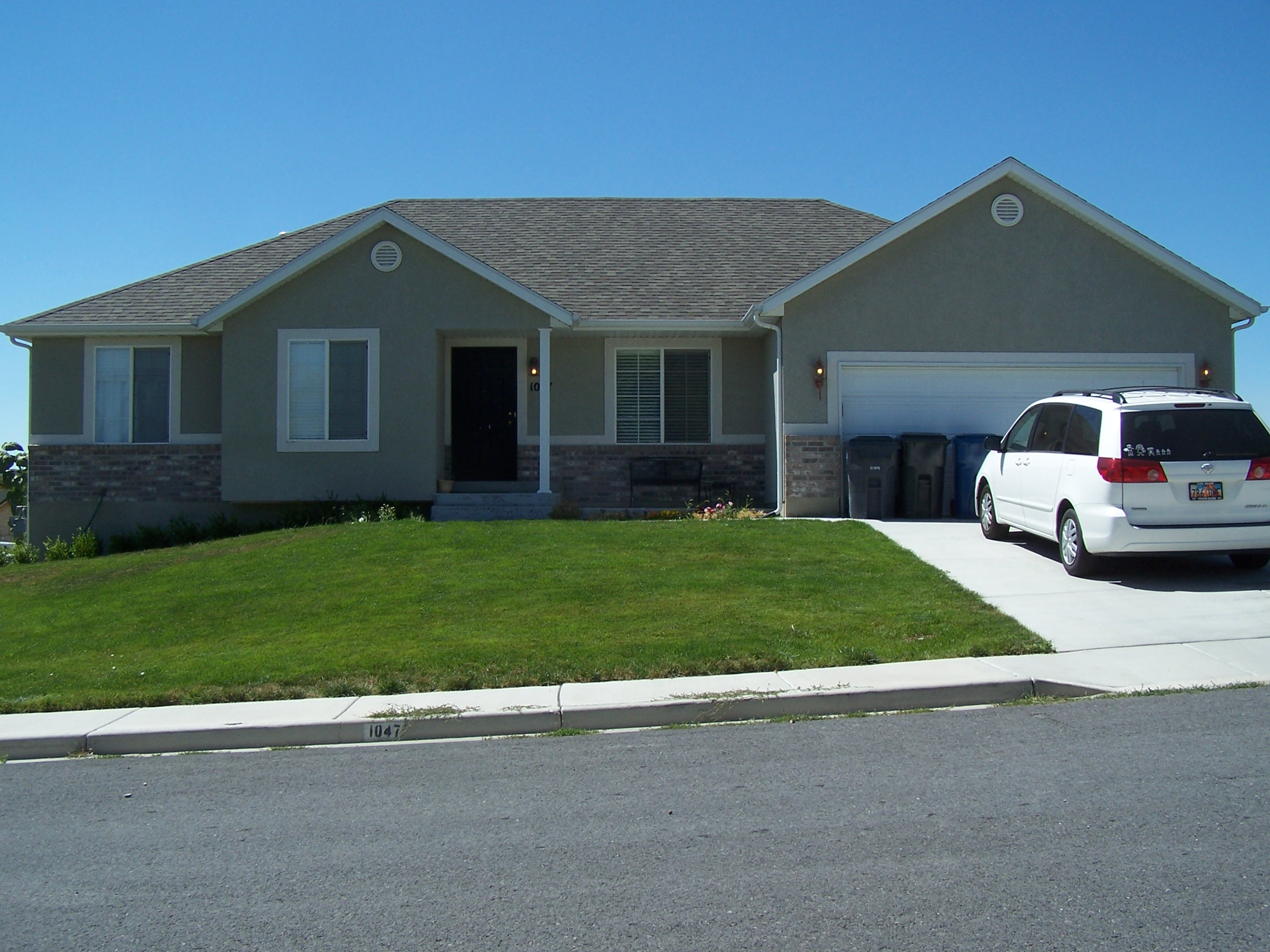
| Property Address: 1047 N 420 WEST - AMERICAN FORK |
|
| Mailing Address: 9090 S SANDY PKWY SANDY, UT 84070 |
|
| Acreage: 0.209 |
|
| Last Document:
21922-2016
|
|
| Subdivision Map Filing |
|
| Taxing Description:
LOT 16, PLAT A, VIRGINIA RIDGE SUBDV. AREA 0.209 AC.
*Taxing description NOT FOR LEGAL DOCUMENTS
|
|
- Owner Names
- Value History
- Tax History
- Location
- Photos
- Documents
- Aerial Image
| |
----- Real Estate Values ----- |
---Improvements--- |
---Greenbelt--- |
Total |
| Year |
Com |
Res |
Agr |
Tot |
Com |
Res |
Agr |
Tot |
Land |
Homesite |
Tot |
Market Value |
| 2024 |
$0 |
$210,700 |
$0 |
$210,700 |
$0 |
$324,600 |
$0 |
$324,600 |
$0 |
$0 |
$0 |
$535,300 |
| 2023 |
$0 |
$210,600 |
$0 |
$210,600 |
$0 |
$328,500 |
$0 |
$328,500 |
$0 |
$0 |
$0 |
$539,100 |
| 2022 |
$0 |
$222,200 |
$0 |
$222,200 |
$0 |
$307,800 |
$0 |
$307,800 |
$0 |
$0 |
$0 |
$530,000 |
| 2021 |
$0 |
$158,700 |
$0 |
$158,700 |
$0 |
$231,400 |
$0 |
$231,400 |
$0 |
$0 |
$0 |
$390,100 |
| 2020 |
$0 |
$141,700 |
$0 |
$141,700 |
$0 |
$212,300 |
$0 |
$212,300 |
$0 |
$0 |
$0 |
$354,000 |
| 2019 |
$0 |
$131,100 |
$0 |
$131,100 |
$0 |
$212,300 |
$0 |
$212,300 |
$0 |
$0 |
$0 |
$343,400 |
| 2018 |
$0 |
$124,000 |
$0 |
$124,000 |
$0 |
$184,600 |
$0 |
$184,600 |
$0 |
$0 |
$0 |
$308,600 |
| 2017 |
$0 |
$106,300 |
$0 |
$106,300 |
$0 |
$178,000 |
$0 |
$178,000 |
$0 |
$0 |
$0 |
$284,300 |
| 2016 |
$0 |
$73,000 |
$0 |
$73,000 |
$0 |
$197,800 |
$0 |
$197,800 |
$0 |
$0 |
$0 |
$270,800 |
| 2015 |
$0 |
$73,000 |
$0 |
$73,000 |
$0 |
$172,600 |
$0 |
$172,600 |
$0 |
$0 |
$0 |
$245,600 |
| 2014 |
$0 |
$67,300 |
$0 |
$67,300 |
$0 |
$167,200 |
$0 |
$167,200 |
$0 |
$0 |
$0 |
$234,500 |
| 2013 |
$0 |
$55,000 |
$0 |
$55,000 |
$0 |
$167,100 |
$0 |
$167,100 |
$0 |
$0 |
$0 |
$222,100 |
| 2012 |
$0 |
$47,700 |
$0 |
$47,700 |
$0 |
$158,200 |
$0 |
$158,200 |
$0 |
$0 |
$0 |
$205,900 |
| 2011 |
$0 |
$47,700 |
$0 |
$47,700 |
$0 |
$162,800 |
$0 |
$162,800 |
$0 |
$0 |
$0 |
$210,500 |
| 2010 |
$0 |
$50,000 |
$0 |
$50,000 |
$0 |
$164,832 |
$0 |
$164,832 |
$0 |
$0 |
$0 |
$214,832 |
| 2009 |
$0 |
$95,500 |
$0 |
$95,500 |
$0 |
$128,300 |
$0 |
$128,300 |
$0 |
$0 |
$0 |
$223,800 |
| 2008 |
$0 |
$102,700 |
$0 |
$102,700 |
$0 |
$149,500 |
$0 |
$149,500 |
$0 |
$0 |
$0 |
$252,200 |
| 2007 |
$0 |
$108,100 |
$0 |
$108,100 |
$0 |
$157,400 |
$0 |
$157,400 |
$0 |
$0 |
$0 |
$265,500 |
| 2006 |
$0 |
$51,300 |
$0 |
$51,300 |
$0 |
$164,700 |
$0 |
$164,700 |
$0 |
$0 |
$0 |
$216,000 |
| 2005 |
$0 |
$51,250 |
$0 |
$51,250 |
$0 |
$107,369 |
$0 |
$107,369 |
$0 |
$0 |
$0 |
$158,619 |
| 2004 |
$0 |
$51,250 |
$0 |
$51,250 |
$0 |
$107,369 |
$0 |
$107,369 |
$0 |
$0 |
$0 |
$158,619 |
| 2003 |
$0 |
$51,250 |
$0 |
$51,250 |
$0 |
$102,019 |
$0 |
$102,019 |
$0 |
$0 |
$0 |
$153,269 |
| 2002 |
$0 |
$51,250 |
$0 |
$51,250 |
$0 |
$0 |
$0 |
$0 |
$0 |
$0 |
$0 |
$51,250 |
| Year |
General Taxes |
Adjustments |
Net Taxes |
Fees |
Payments |
Tax Balance* |
Balance Due |
Tax District |
| 2025 |
$0.00 |
$0.00 |
$0.00 |
$0.00 |
|
$0.00
|
$0.00 |
060 - AMERICAN FORK CITY |
| 2024 |
$2,649.74 |
$0.00 |
$2,649.74 |
$0.00 |
|
$0.00
|
$0.00 |
060 - AMERICAN FORK CITY |
| 2023 |
$2,517.03 |
$0.00 |
$2,517.03 |
$0.00 |
|
$0.00
|
$0.00 |
060 - AMERICAN FORK CITY |
| 2022 |
$2,507.48 |
$0.00 |
$2,507.48 |
$0.00 |
|
$0.00
|
$0.00 |
060 - AMERICAN FORK CITY |
| 2021 |
$2,148.34 |
$0.00 |
$2,148.34 |
$0.00 |
|
$0.00
|
$0.00 |
060 - AMERICAN FORK CITY |
| 2020 |
$2,010.08 |
$0.00 |
$2,010.08 |
$0.00 |
|
$0.00
|
$0.00 |
060 - AMERICAN FORK CITY |
| 2019 |
$1,885.30 |
$0.00 |
$1,885.30 |
$0.00 |
|
$0.00
|
$0.00 |
060 - AMERICAN FORK CITY |
| 2018 |
$1,771.98 |
$0.00 |
$1,771.98 |
$0.00 |
|
$0.00
|
$0.00 |
060 - AMERICAN FORK CITY |
| 2017 |
$1,663.57 |
$0.00 |
$1,663.57 |
$0.00 |
|
$0.00
|
$0.00 |
060 - AMERICAN FORK CITY |
| 2016 |
$1,705.51 |
$0.00 |
$1,705.51 |
$0.00 |
|
$0.00
|
$0.00 |
060 - AMERICAN FORK CITY |
| 2015 |
$1,629.88 |
$0.00 |
$1,629.88 |
$0.00 |
|
$0.00
|
$0.00 |
060 - AMERICAN FORK CITY |
| 2014 |
$1,577.62 |
$0.00 |
$1,577.62 |
$0.00 |
|
$0.00
|
$0.00 |
060 - AMERICAN FORK CITY |
| 2013 |
$1,610.25 |
$0.00 |
$1,610.25 |
$0.00 |
|
$0.00
|
$0.00 |
060 - AMERICAN FORK CITY |
| 2012 |
$1,522.92 |
$0.00 |
$1,522.92 |
$0.00 |
|
$0.00
|
$0.00 |
060 - AMERICAN FORK CITY |
| 2011 |
$1,552.77 |
$0.00 |
$1,552.77 |
$0.00 |
|
$0.00
|
$0.00 |
060 - AMERICAN FORK CITY |
| 2010 |
$1,487.73 |
$0.00 |
$1,487.73 |
$0.00 |
|
$0.00
|
$0.00 |
060 - AMERICAN FORK CITY |
| 2009 |
$1,426.74 |
$0.00 |
$1,426.74 |
$0.00 |
|
$0.00
|
$0.00 |
060 - AMERICAN FORK CITY |
| 2008 |
$1,511.38 |
$0.00 |
$1,511.38 |
$0.00 |
|
$0.00
|
$0.00 |
060 - AMERICAN FORK CITY |
| 2007 |
$1,529.47 |
$0.00 |
$1,529.47 |
$0.00 |
|
$0.00
|
$0.00 |
060 - AMERICAN FORK CITY |
| 2006 |
$1,337.81 |
$0.00 |
$1,337.81 |
$0.00 |
|
$0.00
|
$0.00 |
060 - AMERICAN FORK CITY |
| 2005 |
$1,062.77 |
$0.00 |
$1,062.77 |
$0.00 |
|
$0.00
|
$0.00 |
060 - AMERICAN FORK CITY |
| 2004 |
$1,066.96 |
$0.00 |
$1,066.96 |
$0.00 |
|
$0.00
|
$0.00 |
060 - AMERICAN FORK CITY |
| 2003 |
$1,014.44 |
$0.00 |
$1,014.44 |
$0.00 |
|
$0.00
|
$0.00 |
060 - AMERICAN FORK CITY |
| 2002 |
$569.18 |
$0.00 |
$569.18 |
$0.00 |
|
$0.00
|
$0.00 |
060 - AMERICAN FORK CITY |
* Note: Original tax amount (Does not include applicable interest and/or fees).
| Entry # |
Date |
Recorded |
Type |
Party1 (Grantor) |
Party2 (Grantee) |
| 99769-2022 |
09/08/2022 |
09/13/2022 |
REC |
MORAN, KEVIN P TEE |
JEFFREY, ELIZABETH ELLIS |
| 99768-2022 |
08/27/2022 |
09/13/2022 |
SUB TEE |
MORTGAGE ELECTRONIC REGISTRATION SYSTEMS INC |
MORAN, KEVIN P SUBTEE |
| 93781-2022 |
08/23/2022 |
08/24/2022 |
WD |
JEFFREY, ELIZABETH ELLIS |
PARKWAY PARTNERS LLC |
| 62750-2022 |
05/18/2022 |
05/23/2022 |
REC |
FIRST AMERICAN TITLE INSURANCE COMPANY TEE |
JEFFREY, JOEL & ELIZABETH |
| 62749-2022 |
05/16/2022 |
05/23/2022 |
SUB TEE |
MORTGAGE ELECTRONIC REGISTRATION SYSTEMS INC |
FIRST AMERICAN TITLE INSURANCE COMPANY SUCTEE |
| 55345-2022 |
04/29/2022 |
05/04/2022 |
D TR |
JEFFREY, ELIZABETH ELLIS |
UTAH COMMUNITY FEDERAL CREDIT UNION |
| 55344-2022 |
05/02/2022 |
05/04/2022 |
WD |
JEFFREY, JOEL & ELIZABETH |
JEFFREY, ELIZABETH ELLIS |
| 9731-2020 |
01/24/2020 |
01/27/2020 |
RSUBTEE |
MORTGAGE ELECTRONIC REGISTRATION SYSTEMS INC (ET AL) |
JEFFREY, JOEL & ELIZABETH |
| 2526-2020 |
01/03/2020 |
01/08/2020 |
D TR |
JEFFREY, JOEL & ELIZABETH |
CITYWIDE HOME LOANS LLC |
| 32357-2016 |
04/08/2016 |
04/14/2016 |
REC |
RIVERS, ROD TEE |
HILDEBRANDT, ANTHONY D & DIANA S |
| 32356-2016 |
04/05/2016 |
04/14/2016 |
SUB TEE |
MORTGAGE ELECTRONIC REGISTRATION SYSTEMS INC |
RIVERS, ROD SUCTEE |
| 21923-2016 |
03/14/2016 |
03/15/2016 |
D TR |
JEFFREY, JOEL & ELIZABETH |
ACADEMY MORTGAGE CORPORATION |
| 21922-2016 |
03/11/2016 |
03/15/2016 |
WD |
HILDEBRANDT, ANTHONY D & DIANA S |
JEFFREY, JOEL & ELIZABETH |
| 114949-2008 |
10/20/2008 |
10/22/2008 |
CT |
STATE OF UTAH |
WHOM OF INTEREST |
| 107508-2008 |
09/30/2008 |
09/30/2008 |
RESOL |
BOARD OF COUNTY COMMISSIONERS UTAH COUNTY |
WHOM OF INTEREST |
| 146461-2006 |
10/26/2006 |
11/01/2006 |
REC |
FIRST AMERICAN TITLE INSURANCE AGENCY TEE |
CUFF, R SCOTT & LORI |
| 146460-2006 |
10/25/2006 |
11/01/2006 |
SUB TEE |
MORTGAGE ELECTRONIC REGISTRATION SYSTEMS INC |
FIRST AMERICAN TITLE INSURANCE CO SUCTEE |
| 143078-2006 |
10/23/2006 |
10/26/2006 |
REC |
AMERICA FIRST FEDERAL CREDIT UNION TEE |
CUFF, R SCOTT & LORI |
| 131089-2006 |
10/02/2006 |
10/03/2006 |
REC |
FAR WEST BANK TEE |
CUFF, R SCOTT & LORI |
| 127512-2006 |
09/21/2006 |
09/26/2006 |
D TR |
HILDEBRANDT, ANTHONY D & DIANA S |
MERIDIAS CAPITAL INC |
| 127189-2006 |
09/21/2006 |
09/26/2006 |
WD |
CUFF, R SCOTT & LORI |
HILDEBRANDT, ANTHONY D & DIANA S |
| 93561-2006 |
07/18/2006 |
07/25/2006 |
D TR |
CUFF, R SCOTT & LORI |
FAR WEST BANK |
| 88839-2006 |
05/18/2006 |
07/14/2006 |
REC |
PROVO LAND TITLE COMPANY TEE |
SALISBURY DEVELOPMENT LC |
| 87614-2004 |
07/28/2004 |
07/30/2004 |
RC |
AMERICA FIRST FEDERAL CREDIT UNION |
WHOM OF INTEREST |
| 87613-2004 |
07/28/2004 |
07/30/2004 |
TR D |
CUFF, R SCOTT & LORI |
AMERICA FIRST FEDERAL CREDIT UNION |
| 13779-2004 |
01/15/2004 |
02/06/2004 |
REC |
PROVO LAND TITLE COMPANY TEE |
SALISBURY DEVELOPMENT LC |
| 4764-2004 |
01/14/2004 |
01/14/2004 |
REC |
PROVO LAND TITLE COMPANY TEE |
SALISBURY DEVELOPMENT LC |
| 27912-2003 |
02/21/2003 |
02/26/2003 |
P REC |
PROVO LAND TITLE COMPANY TEE |
SALIBURY DEVELOPMENT LC |
| 22890-2003 |
02/05/2003 |
02/14/2003 |
P REC |
PROVO LAND TITLE COMPANY TEE |
SALISBURY DEVELOPMENT LC |
| 16815-2003 |
01/21/2003 |
02/04/2003 |
REC |
PROVO LAND TITLE COMPANY TEE |
SALISBURY DEVELOPMENT LC |
| 141399-2002 |
11/20/2002 |
11/22/2002 |
D TR |
CUFF, R SCOTT & LORI |
NEW LINE MORTGAGE DIV OF (ET AL) |
| 141398-2002 |
11/19/2002 |
11/22/2002 |
WD |
SALISBURY DEVELOPMENT LC |
CUFF, R SCOTT & LORI |
| 119327-2002 |
10/07/2002 |
10/09/2002 |
D TR |
SALISBURY DEVELOPMENT LC |
ANDERSON LUMBER COMPANY |
| 87554-2002 |
05/13/2002 |
08/01/2002 |
R EAS |
QWEST CORPORATION |
WHOM OF INTEREST |
| 134763-2001 |
12/20/2001 |
12/21/2001 |
TR D |
SALISBURY DEVELOPMENT |
VIRGINIA RIDGE LC |
| 134762-2001 |
12/20/2001 |
12/21/2001 |
WD |
VIRGINIA RIDGE LC |
SALISBURY DEVELOPMENT LC |
| 43297-2001 |
02/27/2001 |
05/03/2001 |
S PLAT |
VIRGINIA RIDGE LLC (ET AL) |
VIRGINIA RIDGE PLAT A |
Main Menu Comments or Concerns on Value/Appraisal - Assessor's Office
Documents/Owner/Parcel information - Recorder's Office
Address Change for Tax Notice
This page was created on 4/1/2025 2:17:21 PM |

