Property Information
mobile view
| Serial Number: 65:312:0002 |
Serial Life: 2009... |
|
|
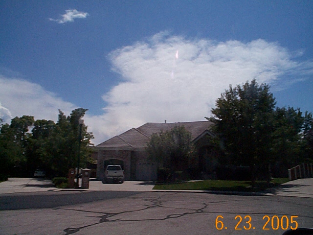
Total Photos: 1
|
| |
|
|
| Property Address: 1038 S COVENTRY CIR - OREM |
|
| Mailing Address: 1038 S COVENTRY CIR OREM, UT 84097 |
|
| Acreage: 0.335 |
|
| Last Document:
86991-2017
|
|
| Subdivision Map Filing |
|
| Taxing Description:
LOT 2, PLAT C, COVENTRY ESTATES SUBDV. AREA 0.335 AC.
*Taxing description NOT FOR LEGAL DOCUMENTS
|
|
- Owner Names
- Value History
- Tax History
- Location
- Photos
- Documents
- Aerial Image
| |
----- Real Estate Values ----- |
---Improvements--- |
---Greenbelt--- |
Total |
| Year |
Com |
Res |
Agr |
Tot |
Com |
Res |
Agr |
Tot |
Land |
Homesite |
Tot |
Market Value |
| 2024 |
$0 |
$272,800 |
$0 |
$272,800 |
$0 |
$536,000 |
$0 |
$536,000 |
$0 |
$0 |
$0 |
$808,800 |
| 2023 |
$0 |
$272,800 |
$0 |
$272,800 |
$0 |
$506,900 |
$0 |
$506,900 |
$0 |
$0 |
$0 |
$779,700 |
| 2022 |
$0 |
$290,900 |
$0 |
$290,900 |
$0 |
$562,700 |
$0 |
$562,700 |
$0 |
$0 |
$0 |
$853,600 |
| 2021 |
$0 |
$181,800 |
$0 |
$181,800 |
$0 |
$446,600 |
$0 |
$446,600 |
$0 |
$0 |
$0 |
$628,400 |
| 2020 |
$0 |
$145,400 |
$0 |
$145,400 |
$0 |
$433,600 |
$0 |
$433,600 |
$0 |
$0 |
$0 |
$579,000 |
| 2019 |
$0 |
$145,400 |
$0 |
$145,400 |
$0 |
$377,000 |
$0 |
$377,000 |
$0 |
$0 |
$0 |
$522,400 |
| 2018 |
$0 |
$145,400 |
$0 |
$145,400 |
$0 |
$357,500 |
$0 |
$357,500 |
$0 |
$0 |
$0 |
$502,900 |
| 2017 |
$0 |
$137,600 |
$0 |
$137,600 |
$0 |
$357,500 |
$0 |
$357,500 |
$0 |
$0 |
$0 |
$495,100 |
| 2016 |
$0 |
$90,400 |
$0 |
$90,400 |
$0 |
$357,500 |
$0 |
$357,500 |
$0 |
$0 |
$0 |
$447,900 |
| 2015 |
$0 |
$90,400 |
$0 |
$90,400 |
$0 |
$310,881 |
$0 |
$310,881 |
$0 |
$0 |
$0 |
$401,281 |
| 2014 |
$0 |
$84,900 |
$0 |
$84,900 |
$0 |
$292,200 |
$0 |
$292,200 |
$0 |
$0 |
$0 |
$377,100 |
| 2013 |
$0 |
$79,200 |
$0 |
$79,200 |
$0 |
$254,100 |
$0 |
$254,100 |
$0 |
$0 |
$0 |
$333,300 |
| 2012 |
$0 |
$86,400 |
$0 |
$86,400 |
$0 |
$292,100 |
$0 |
$292,100 |
$0 |
$0 |
$0 |
$378,500 |
| 2011 |
$0 |
$93,000 |
$0 |
$93,000 |
$0 |
$289,300 |
$0 |
$289,300 |
$0 |
$0 |
$0 |
$382,300 |
| 2010 |
$0 |
$80,000 |
$0 |
$80,000 |
$0 |
$326,570 |
$0 |
$326,570 |
$0 |
$0 |
$0 |
$406,570 |
| 2009 |
$0 |
$80,000 |
$0 |
$80,000 |
$0 |
$328,460 |
$0 |
$328,460 |
$0 |
$0 |
$0 |
$408,460 |
| Year |
General Taxes |
Adjustments |
Net Taxes |
Fees |
Payments |
Tax Balance* |
Balance Due |
Tax District |
| 2025 |
$0.00 |
$0.00 |
$0.00 |
$0.00 |
|
$0.00
|
$0.00 |
090 - OREM CITY |
| 2024 |
$0.00 |
$0.00 |
$0.00 |
$0.00 |
|
$0.00
|
$0.00 |
090 - OREM CITY |
| 2023 |
$3,263.01 |
$0.00 |
$3,263.01 |
$0.00 |
|
$0.00
|
$0.00 |
090 - OREM CITY |
| 2022 |
$3,687.30 |
$0.00 |
$3,687.30 |
$0.00 |
|
$0.00
|
$0.00 |
090 - OREM CITY |
| 2021 |
$3,258.51 |
$0.00 |
$3,258.51 |
$0.00 |
|
$0.00
|
$0.00 |
090 - OREM CITY |
| 2020 |
$3,054.89 |
$0.00 |
$3,054.89 |
$0.00 |
|
$0.00
|
$0.00 |
090 - OREM CITY |
| 2019 |
$2,650.53 |
$0.00 |
$2,650.53 |
$0.00 |
|
$0.00
|
$0.00 |
090 - OREM CITY |
| 2018 |
$2,670.52 |
$0.00 |
$2,670.52 |
$0.00 |
|
$0.00
|
$0.00 |
090 - OREM CITY |
| 2017 |
$2,699.36 |
$0.00 |
$2,699.36 |
$0.00 |
|
$0.00
|
$0.00 |
090 - OREM CITY |
| 2016 |
$2,648.21 |
$0.00 |
$2,648.21 |
$0.00 |
|
$0.00
|
$0.00 |
090 - OREM CITY |
| 2015 |
$2,508.75 |
$0.00 |
$2,508.75 |
$0.00 |
|
$0.00
|
$0.00 |
090 - OREM CITY |
| 2014 |
$2,368.36 |
$0.00 |
$2,368.36 |
$0.00 |
|
$0.00
|
$0.00 |
090 - OREM CITY |
| 2013 |
$2,257.34 |
$0.00 |
$2,257.34 |
$0.00 |
|
$0.00
|
$0.00 |
090 - OREM CITY |
| 2012 |
$2,616.34 |
$0.00 |
$2,616.34 |
$0.00 |
|
$0.00
|
$0.00 |
090 - OREM CITY |
| 2011 |
$2,629.99 |
$0.00 |
$2,629.99 |
$0.00 |
|
$0.00
|
$0.00 |
090 - OREM CITY |
| 2010 |
$2,618.52 |
$0.00 |
$2,618.52 |
$0.00 |
|
$0.00
|
$0.00 |
090 - OREM CITY |
| 2009 |
$2,512.28 |
($73.67) |
$2,438.61 |
$0.00 |
|
$0.00
|
$0.00 |
090 - OREM CITY |
* Note: Original tax amount (Does not include applicable interest and/or fees).
| Entry # |
Date |
Recorded |
Type |
Party1 (Grantor) |
Party2 (Grantee) |
| 86991-2017 |
09/05/2017 |
09/06/2017 |
WD |
BRAMMER, RICHARD D & JEAN H |
BRAMMER, RICHARD D & JEAN H TEE (ET AL) |
| 86990-2017 |
09/05/2017 |
09/06/2017 |
D TR |
BRAMMER, RICHARD D & JEAN H |
FREEDOM CREDIT UNION |
| 86989-2017 |
09/05/2017 |
09/06/2017 |
WD |
BRAMMER, RICHARD D & JEAN H TEE (ET AL) |
BRAMMER, RICHARD D & JEAN H |
| 112464-2008 |
09/03/2008 |
10/15/2008 |
S PLAT |
CARLSON, JOSEPH W & MELBA J TEE (ET AL) |
COVENTRY ESTATES PLAT C |
Main Menu Comments or Concerns on Value/Appraisal - Assessor's Office
Documents/Owner/Parcel information - Recorder's Office
Address Change for Tax Notice
This page was created on 8/12/2024 12:04:16 AM |